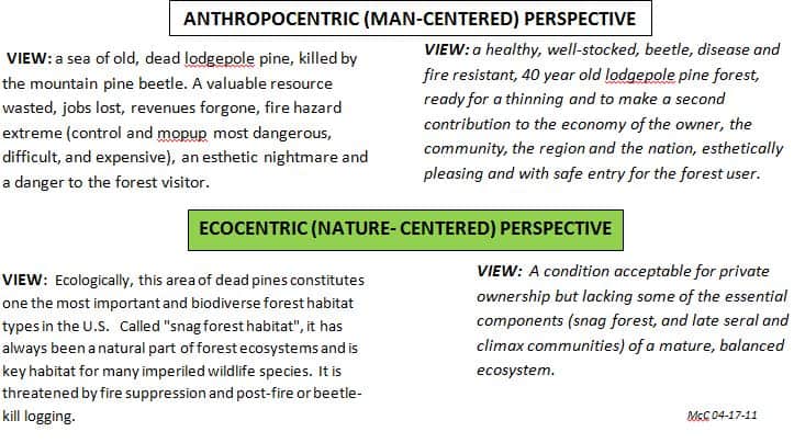
Posts and comments in this and other forums reveal widespread misunderstanding of, and sometimes disrespect for, the viewpoint of others. The graphic may help to make clear the difference between two world views, recognizing that both are strongly held and that both have merit.
Application of these opposing philosophies to land management results in totally different outcomes. While short-term effects may be readily apparent, long-term impacts are often unpredictable. To make matters more complicated, the “goodness” of each outcome is dependent on the viewpoint of the observer, as the graphic’s text demonstrates.
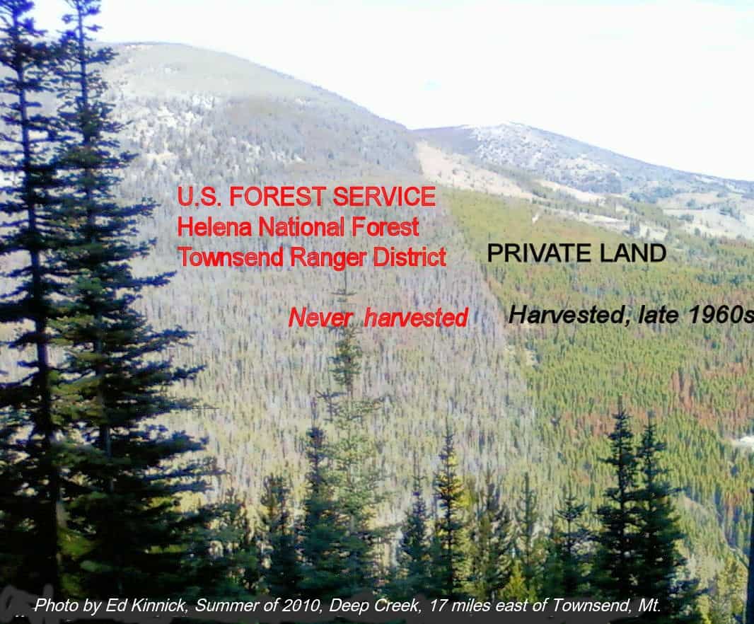
The land on left side, of the photo, while controlled (but virtually unmanaged) by the U.S. Forest Service, belongs to you. Study the photo and ask yourself “On how much of my land do I want Nature to take its course?”. Al of it? Some of it? None of it? If “some”, what percentage?
Your land managers (Congress and the Forest Service), and your fellow readers, await your decision.
Factoid: National Forests contain 36 million acres of formally designated wilderness areas or ~19% of the land area.
Can we get some clarity and current information on this location?
What is the direction in which this photo was taken and what orientation does it have to Highway 12?
What is the current status? Has the scene changed since 2010?
The original photo would also help. This one is so fuzzy it is impossible to analyze.
As we have discovered in previous posts using photo points, Google Earth can reveal a significantly different perspective.
To be honest, this blanket assumption of blame against the USFS in favor of private industry is a false dichotomy that is not helpful in creating a constructive discussion.
Richard, I’ve asked the provider of this photo to send me the location of the photo point and the azimuth of the shot. Stay tuned.
A word of caution about Google Earth. Standing dead trees that have lost their foliage show up as tiny grey dots and are identifiable only by their shadows. When they occur in a stand with understory vegetation, as is the case with the Deep Creek photo, they are virtually undetectable. A good example of this can be seen at 46,19,24.98N 111,10,27.88W where down dead trees are clearly visible while the presence of snags is revealed by their shadows. This is true even on “oblique” or panoramic views which are vertical shots that have been stitched together.
Re your last paragraph. I did my best not to assign “blame” on anyone. The post shows a photo and then states the fact the public land shown is “virtually unmanaged” . It then presents contrasting views as to the “meaning” or significance of the photo, and finally requested your view of the management styles depicted as models for public lands.
There are a multitude of “blames” (or credits?) that can be assigned for the condition of the public land in the photo: under funding, serial litigation, over-regulation, over-analysis, lack of agency leadership, Canadian lumber competition, housing market decline, dysfunctional congress – we’ve heard them all on this blog. Everyone is responsible and no-one is responsible.
The real purpose of my post was to encourage us to venture outside of the walls we have built around our minds. To that end, may I repeat the question that so far no-one has answered: “On how much of my land do I want Nature to take its course?”. All of it? Some of it? None of it? If “some”, what percentage? .
I’d refer you the conversation taking place between Greg and myself in the “Federal Lands support diverse economies” post, Mac. We are definitely discussing “on how much land nature should take it’s course.”
I provided a generic answer to the “how much” question earlier, which puts some sideboards on specific answers. A specific answer depends on which piece of “my land” we’re talking about (the “where” question is usually pretty important), and (of course) on the mandated planning process for that land.
Mac, I get what your post is attempting to show. I appreciate your challenge in terms of how much management we want, need. The questions you posed are excellent ones, as are the summaries of the two opposing philosophies. The problem I’m having with the photo and what it implies is that similar ones have been used by the anti-public lands crowd who want all parks, national forests, etc. to be handed over to the private sector. The message is, “See, all our forests are so green and healthy, the government’s are ugly.”
All the photo shows is a pleasingly green forest on the right and one full of dead trees on the left. What is not demonstrated in the photo, one the causal observation will never get, is what the two environments mean ecologically. Which one supports greater biodiversity? Granted, you spelled out the biodiversity value issue well in the opposing philosophies, but I think the discussion would have been better served if the photo had been left out. Why? Because the photo can only portray one position to the general public, which is contrary to the intent of your well written post.
Anyway, maybe you can add two opposing quotes instead of a photo. Here’s my suggestion for the nature-centered view:
“Simply because humankind have the power now to meddle or ‘manage’ or ‘exercise stewardship’ in every nook and cranny of the world does not mean that we have a right to do so. Even less, the obligation.”
― Edward Abbey
I agree the photo is problematic because it frames the debate in a biased way. Perhaps if a second photo was added showing fragmented, degraded private land (mine tailings and smoke stacks perhaps?) next to healthy national forest land.
I think most of us would agree a benevolent private owner can potentially manage most forest lands better than nature or government, but that doesn’t mean they do. Private forest owners manage their land to provide the maximum revenue stream at minimal cost. That is not how I want my public lands managed, but I don’t want them ‘managed’ for minimal revenue at maximum cost, either. Our forests should yield timber, harvested from productive sites where such harvest does not compromise other values. They should also yield clean water, wildlife habitat, recreation opportunities, etc. There should even be areas we completely leave alone, making a management decision to let nature do its will good, bad, or ugly. How much should we allocate to each use? As Jon alluded above, that all depends on ‘where’ the forest is.
Richard, Here’s a belated response to the questions raised in you June 30 post. I contacted the provider of the photo and the District Ranger to get further info. I don’t have the location or azimuth of the photo point but the location of the stand in the photo is 46°24’49.82”N, 111°09’33.71”W. this stand is located within the gross sale area of the Cabin Gulch Vegetation Treatment Project, in which 2890 acres are receiving a variety of treatments including improvement cuts, prescribed fire, whitebark pine restoration, thinning, and salvage. 330 acres was beetle kill salvage. The project , now 85% completed, was unsuccessfully challenged by the Alliance for Wild Rockies and Native Ecosystem Council.
The subject stand was not included in the treatment area (logging would harm the dense pine pole understory?) and is unchanged from the 2010 photo, still providing snag forest habitat.
Thanks Mac.
Whether or not this particular photo comparison is accurate, I think the two perspectives presented do a good job of capturing the opposing views. Fortunately we don’t have to debate them for national forests because we have decided that the anthropocentric “greatest good for the greatest number” can best be provided by managing for diversity and ecological integrity. A landscape lacking essential ecosystem components (or processes, like fire) would not meet this requirement.
For whatever it’s worth…
The following google image is from an area approximately 17 miles west of Townsend, Montana and appears to include the only area west of Townsend which has a clear boundary line. I believe the photo Mac provided (which he has trotted out numerous times over the past few years on this blog) is somewhere in the middle of this google image.
As far as I can tell, and from my perspective, this entire area (private and public lands) is pretty hammered from logging and roadbuilding.
I appreciate the effort to represent different perspectives about how these forests can be viewed, but I personally do not think that 40 year old plantations are aesthetically pleasing, nor do I think snag-rich forests are aesthetic “nightmares.”
I would much rather see my public forests passively managed with mortality and other ecological processes operating freely, rather than converted to sterile plantations, with ecological processes suppressed and virtually 100% of mortality exported.
Strawman Alert! “You’re with us or you’re against us!”
The trees on private land in the photo iare not a “sterile plantation” but, rather, is lodgepole pine regeneration, the result of nature taking its course.
Well, it’s more accurate to say “nature took it’s course” regenerating lodgepole pine AFTER humans had their way. At least they didn’t have to go to the expense of planting (I assume).