Stewardship contracts – a better tool for the job than a roadless rule?

I wouldn’t have thought that one is a substitute for the other, and maybe this suggests that Utah defined its problem wrong initially.  But they’re happy enough with the way their Shared Stewardship agreement is working that they have put their roadless rule proposal on a back burner.  At least some greens seem happy, too, and least those concerned about roadless areas.  Priority-setting, within the framework of a forest plan, is one thing that I think lends itself to collaboration.

Amid debate about state-specific exemptions to the Roadless Rule, Congress created the capacity to negotiate “stewardship contracts” ranging up to 20 years with states in the 2018 Consolidated Appropriations Act.  It allows the Forest Service to rely on “state’s guidance for designing, implementing, and prioritizing projects geared toward reducing the risks of damaging wildfires and promoting forest health.”


Wilderness Society Senior Resource Analyst for National Forest Policy Mike Anderson said conservationists are encouraged by what Shared Stewardship agreements could foster in addressing critical needs.  “Working side-by-side to identify the major risks and implement projects that are actually going to make a difference on the land is something conservationists, I think, can generally can support,” he said. “We think it is good.”


(Utah Public Lands Policy Coordinating Office lead counsel) Garfield said under the agreement, projects “can happen, and are occurring, within and without the roadless area, when necessary.”    ‘The existing rule provides a lot of exceptions that the Forest Service can use for forest restoration,” he said. “The Forest Service wasn’t using those” exceptions in many cases.  Garfield said PLPCO will be watching closely over the next four years to see if the Shared Stewardship agreement works out before withdrawing its petition. “I won’t say everything we hoped to accomplish under a state-specific Roadless Rule will be achieved under the Shared Stewardship agreement,” he said, “but a lot of progress is being made.”

(One error in this article – the Idaho and Colorado state roadless rules have been approved.)
Forest planning for wildlife corridors

The 2012 Planning Rule requires that forest plan revisions address wildlife habitat connectivity. In fact it is one of the “dominant ecological characteristics” that must occur with the “natural range of variation” in order to meet the substantive regulatory requirement for “ecological integrity” and the NFMA statutory requirement for “plant and animal diversity.” The Rio Grande National Forest doesn’t seem to want to take this seriously in its revised forest plan, as recounted here:

“At the federal level, New Mexico Sen. Tom Udall and others have proposed a Wildlife Corridors Conservation Act to create more tools for protecting migration routes. Our neighbors in New Mexico passed a state wildlife corridors act earlier this year. Colorado Parks and Wildlife has emphasized the need to ratchet up awareness and protection of corridors. And even former Interior Secretary Ryan Zinke issued an order to conserve big-game migration corridors and winter range.

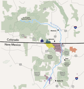
“Hence, with all of this activity agitating for increased concern and elevated action to protect wildlife corridors, the new management plan just announced by the Rio Grande National Forest is astonishingly tone deaf. Our national forest neighbors to the east finalized their long-awaited 20-year vision and ignored widespread calls for action to elevate wildlife corridors.

“It’s a disappointing example of compartmentalization taken to the extreme. Immediately adjacent across the state line in New Mexico, the Carson National Forest unveiled its draft plan and highlighted extraordinary wildlife values there around San Antonio Mountain with a dedicated Wildlife Management Area.  But it’s as though an administrative wall exists at the state line.”

“Having the Interior Department and state wildlife agencies and elected officials and some national forests all calling for action to protect wildlife corridors isn’t enough if one critical player, like the Rio Grande National Forest, is missing in action.”

It only takes one bad actor to ruin a wildlife corridor. That is a reason why connectivity was given such a high profile in national forest planning for diversity (I was there). The Rio Grand is currently taking objections to its final revised plan, which will be reviewed by someone at the regional level to determine if the Forest is meeting its connectivity/diversity obligations.  However, this is a cross-regional problem (Region 2 and Region 3), which is why the national office of the Forest Service needs to look at why forests in two regions can’t get their acts together on what conditions are needed for connectivity.

Maybe they should also take a look at a recent example in Region 4. This is a case where a state-recognized wildlife corridor led to changes in a trail project on the Bridger-Teton National Forest.

“The now-scrapped trail could have interfered specifically with the Red Desert-to-Hoback mule deer migration corridor, which was the first route designated by the state of Wyoming. An estimated 4,000 to 5,000 deer pass through the narrow bottleneck at the Fremont Lake outflow, according to a 2016 assessment of the migration path.”

‘The “desired future conditions” — a U.S. Forest Service equivalent for zoning — for where the trail would have gone are “developed and administrative sites” and “special use/recreation.” Those classifications would have allowed for new trails, and the Bridger-Teton’s forest plan easily predates the discovery of the migration route, which wasn’t until 2013. Outside of those processes, the forest sought input before proceeding with the plans.”

It’s great that the project decision is considering this new information and the new state designation.  I hope the Forest also recognizes the implications for any future projects in this area where it looks like they have decided that the desired condition is now something else.  The discovery of the migration route should have led to another look at the forest plan desired condition, and a plan amendment if they are deciding that it is no longer appropriate based on this new information.


Mark Twain to eliminate hunting at request of state

Source

Of feral hogs that is.  In kind of a turnabout from typical conflicts between states and feds, this is a disagreement between the state and counties (and the hog hunting segment of the public).  (There was some discussion of federal regulation of hunting on the Kisatchie National Forest here.)

The State of Missouri is undertaking a trapping program, which they say that hunting interferes with.  The Forest Service is proposing to use its federal land management authority to issue a closure order to prohibit hunting of feral hogs on the Mark Twain National Forest.  From the Forest Service website linked to this article:

Mark Twain National Forest is proposing a Forest Closure Order to support interagency efforts to eliminate feral swine (also known as feral hogs) in Missouri. The Forest Closure Order would prevent the taking, pursuing or releasing of all feral swine on the forest. The only exception would apply to feral swine elimination efforts conducted by the interagency task force.

The proposal is in response to a Missouri Department of Conservation (MDC) request to make policies consistent across all public lands in Missouri to halt the spread of feral swine and the resulting damage they cause. The State of Missouri feral swine elimination program bans all taking, pursuing or releasing of feral swine on state lands. The State asked the Forest Service and National Park Service for support as part of the Missouri Feral Hog Partnership. The proposed closure order would align lands managed by the Forest Service with the efforts of Missouri and other federal agencies, including USDA Animal and Plant Health Inspection Service.

On the Kisatchie, the Forest Service used a forest plan amendment to provide long-term direction.  Here, the forest plan is not mentioned, so presumably the closure is viewed as short-term – until the hogs are gone, but from what I hear, good luck with that.

Forest Service not sued on timber project

I couldn’t find the project files for the Gatton’s Park fuels treatment project in the Upper Mimbres Valley on the Gila National Forest, but it seemed like it has a lot of features that make it a good example of how to not get sued –

The Nature Conservancy received an initial Collaborative Forest Restoration Program grant for planning the project from 2012 through 2014; when the National Environmental Policy Act process was finished, the Grant Soil and Water Conservation District was awarded an additional grant and took over implementation of the plan beginning in January 2018.

In addition to local residents and logging businesses, the county government, the Forest Service, firefighters, conservationists and wildlife habitat advocates are also seeing the benefit of working together.

So far, thinning has reduced fuels from 50 tons per acre down to 15 tons in treated parts of the 1,500-acre project area and reduced fuels by half in other treated parts of the project area — something that will give residents on the edge of the Gila Forest in the Gatton’s Park development, in particular, a better chance of surviving a wildfire without catastrophic damage. The border of forest land and developed land is known as a “wildland urban interface.”

Partido emphasized the difference between a regular timber contract and the current project. Both attain forest management goals, especially in the area of fire prevention, but the Collaborative Forest Restoration Program is more efficient. “There hasn’t been a timber sale in these parts since the 1950s,” Partido said.

Part of the silvicultural prescription provided by the Forest Service — the tree plan — also takes into account habitats for the threatened Mexican spotted owls in the Gila. Trees over certain diameters are left in place — as are trees with holes where owls might nest.

What happens to the trees that are cut? The two contractors are either bringing the logs to sawmills and making poles and other products out of them or turning them into wood chips — piles of which are regularly offered to anyone who wants to come pick them up, for free. “Some of the ponderosa logs will be brought to the Celebration campground and other campgrounds for people to use,” Carver said.

Bark Beetle Epidemic in Calaveras County


The bark beetles started their invasion when I used to live there, in Mark Twain’s famous Calaveras County. Now it looks like it has reached epidemic levels, requiring emergency action, from multiple agencies.

http://www.calaverasenterprise.com/news/article_fbc896b8-7d6f-11e9-94ea-7b4b381822a0.html

Even with recent wet winters, tree mortality will remain a pressing issue as long as bark beetle infestations and drought conditions continue, said Brady McElroy, a hazard tree specialist in the Calaveras Ranger District of the Stanislaus National Forest.

“By no means is the issue going away,” McElroy said. “What the Forest Service has to focus on are the high priority areas, the immediate hazards to homes, roads and highways.”

In the long-term, McElroy said the Forest Service hopes to increase the pace and scale of thinning projects to restore overstocked forests that have been allowed for by a century of fire suppression.

“Our forests are overstocked, which increases competition (and) stressors on the trees, (and consequently) their ability to defend against bark beetle,” McElroy said. “The ongoing goal is to thin forests to a healthy kind of pre-European settlement stand to where they’re a little more resilient. We’re focusing on high-priority areas in the wildland-urban interface … We know what happens when these overstocked forests catch fire – we lose them.”

Diana Fredlund, a public affairs officer with the Stanislaus National Forest, said that although federal budget decreases have impacted the scale of the work for the Forest Service, the agency has been able to collaborate with private, county, state and other federal agencies and contractors for tree removal projects.

“We do what we can with what we have,” Fredlund said.

The Forest Service offers its own tree mortality program for homeowners with properties adjacent to Forest Service land. Property owners can fill out a Hazard Tree Evaluation Request Form to be considered for hazard tree abatement.

Utah vs. Nevada

In a discussion of “privatization,” Brian Hawthorne suggested here that, “It might be worthwhile discussing our perceived distinctions between what Utah’s HB 148 contemplates vs the “small tract sales” made pursuant to the SNPLMA.” That would require some knowledge of what both of these things are.

This summary of Utah’s H.B. 148 is from a review by an attorney from the conservative Federalist Society.

Recent legislation passed in the State of Utah has demanded that the federal government extinguish title to certain public lands that the federal government currently holds. The State of Utah claims that the federal government made promises to it (at statehood when the federal government obtained the lands) that the federal ownership would be of limited duration and that the bulk of those lands would be timely disposed of by the federal government into private ownership or otherwise returned to the State.

On March 23, 2012, Governor Gary Herbert of the State of Utah signed into Utah law the “Transfer of Public Lands Act and Related Study,” (“TPLA”) also commonly referred to House Bill 148 (“H.B. 148”). This legislation demands that the federal government “extinguish” its title to an estimated more than 20 million (or by some reports even more than 30 million ) acres of federal public lands in the State of Utah by December 31, 2014. It also calls for the transfer of such acreage to the State and establishes procedures for the development of a management regime for this increased state portfolio of land holdings resulting from the transfer.

This is from the Southern Utah Wilderness Association, described by another poster here as “unwilling … to compromise with any other interest group.”

HB 148 requires, among other things, the federal government to transfer title of federal public lands in Utah to the state before January 1, 2015.  These public lands include lands managed by the Bureau of Land Management, Forest Service, U.S. Fish and Wildlife Service, and National Park Service.

  • They include, among others, sensitive sites such as Grand Staircase-Escalante National Monument, Glen Canyon National Recreation Area, and all national wildlife refuges in the state.
  • This would also include the overwhelming majority of remarkable red rock lands surrounding Moab, the San Rafael Swell, and Grand Gulch.
  • The Legislature has indicated that some of these lands would be sold outright to the highest bidder while others would be kept in state ownership but opened to oil and gas drilling, off-road vehicle use and extractive industries.
  • The bill does not require the transfer of national parks, wilderness areas, or certain national monuments and national historic sites.

Here is a summary of the Southern Nevada Public Land Management Act (from this OIG Report).

Las Vegas, one of the fastest growing cities in the United States, is landlocked by federal lands. Over the past decade, the population has increased by more than 60,000 people per year. To accommodate this rapid growth and expedite the disposal of federal land, Congress enacted SNPLMA in 1998 (Public Law 105-263, 31 USC 6901). SNPLMA allows BLM to sell federal land (about 27,000 acres) primarily through public auctions, establish a special U.S. Treasury interest-bearing account, and use the resulting receipts for educational and environmental purposes and capital improvements. In addition, SNPLMA directed BLM to transfer ownership of about 5,200 acres of land in the McCarran Airport Cooperative Management Area (CMA) to Clark County to help the County enforce regulations concerning airport noise within the CMA. BLM is entitled to 85 percent of any receipts from the sale, lease, or other conveyance of CMA lands.

I’m afraid I don’t see much similarity. The justifications are at opposite ends of the scale from a localized problem to a disagreement about overall management policies. The difference in the affected area is huge.  There are benefits returning to the American public from the Las Vegas land sale proceeds.  Perhaps it’s a slippery slope (next Los Angeles, Salt Lake City, Missoula …?), but H.B. 148 represents the bottom of that slope.

Recovery from Waldo Canyon: WGA Working Lands Roundtable Presentation by Sallie Clarke


The Western Governors’ Association has been having a Working Lands Roundtable with sessions on different topics.  I previously posted on a session here.  Here is a link to the presentations- they are all on video. Nothing “newsworthy” happened there. For me, as a retiree who doesn’t work daily with the folks slogging through this kind of work, I realized how much the media I read influences the way I think about what’s going on in the world.  In our forest policy arena, that means that controversies are visible (Bernhardt! Bears Ears!) and the day-to-day work (and non-partisanized successes) mostly invisible.  Speakers mostly discussed  what they wanted to do together, what is helpful and what is problematic, as kind of a large-scale team effort;  to be sure, influenced, but not circumscribed by,  the shifting winds of DC politics and the randomness of court cases.

I’ve mentioned before that sometimes there is a contrast between “people who deal with ideas about things” and “people who deal with things.”  Ideas about things are usually part of academia, other kinds of researchers,  and think tanks. Ideas about things can also be part of partisan narratives, or narratives promoted by unknown funding sources for their unknown reasons.  “People who deal with things” include firefighters, county commissioners, homeowners, agency employees, farmers and ranchers, and so on. These WGA workshops are relatively unique in that the speakers tend to be people who deal with things.

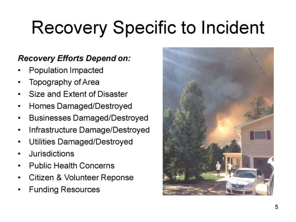
For example, I think this Youtube clip of a talk by former El Paso County Commissioner Sallie Clarke shows what it’s like to be on the ground working with communities during and post fire. Clarke’s presentation caused me to reflect on her and El Paso County’s experience compared to some of the ideas that are floating around out there.

(1) One is “wildfires wouldn’t be a problem if people wouldn’t build houses in fire prone country.”  New building may increase the acreage with house, infrastructure and evacuation problems, but fires are still problems with the towns, cities and communities that are already built.  Plus the communities downstream from where the big fires are. So being careful about adding buildings is important, but will not make wildfire/human problems go away.

The second idea is often associated with Jack Cohen’s work on structures and says that (2) if you want to protect homes or other buildings, you need to focus on fire-resilient building materials and a zone close to the house.  Again, that is an academic answer framed as being about structures, not people in communities.  The approach again, is important but not sufficient.  No one wants fire burning through their communities, even if it doesn’t burn down their houses and neighborhood infrastructure. Talk to someone who has lived through an evacuation.  Talk to someone who has large animals to move during an evacuation, which is not uncommon in El Paso County.  Talk to someone who was trying to evacuate and the roads were blocked, and had to decide whether to leave the car and run for it. Just.. not a good idea.

(3) The third idea is “you don’t need fuel treatments if the treatments are not adjacent to houses.” Yet wildfires can cause flooding that is often not good for the environment and destructive to communities and people- anywhere downstream. We often hear about “the vegetation needs high intensity fires to return to HRV or NRV”  but it’s not all about the veg.  Do hydrologists or fish bios get to weigh in on their own “desired range of variation?”  Wildfires not directly adjacent to communities can still impact them via flooding, silting up reservoirs and other impacts.

For some reason, post-fire flooding doesn’t seem to get the media or academic coverage that wildfires do themselves. Perhaps there’s no controversy or drama.  But if you want to get a feel for the things people need to do to slow water and reduce flooding post-fire, and the collaborations involved, check out Sallie Clark’s presentation or slides.

Greater sage-grouse amendment amendment

Three years ago the Forest Service had this to say about the greater sage-grouse:

Two US Forest Service Records of Decision and associated land management plan amendments are the culmination of an unprecedented planning effort in cooperation with the Bureau of Land Management to conserve greater sage-grouse and its habitat on National Forest System lands and Bureau of Land Management-administered lands.

Last week it was this (and they initiated a public comment period):

Since approving the plan amendments in 2015, the Forest Service has gathered information and determined that the conservation benefits of Forest Service plans in Nevada and other states can be improved. That is, through repeated scoping, close collaboration with state and other federal agencies, and internal review, the Forest Service has identified proposed changes in the text of the greater sage-grouse plan amendments which would improve their clarity and efficiency and better align them with the Bureau of Land Management and state plans.

Specifically, the Preferred Alternative makes modifications to land management plans within the issue areas of: Habitat management area designation, including designating sagebrush focal areas as Priority Habitat Management Areas compensatory mitigation and net conservation gain; minerals plan components and waivers; exceptions and modifications; desired conditions; livestock grazing guidelines; adaptive management; treatment of invasive species; and changes to clarify text and eliminate errors and redundancies.

Oddly, it sounds like all of the new information must say that sage-grouse are doing better than we thought three years ago and/or they are less vulnerable to oil and gas drilling than we thought three years ago. The most important change in forest plans is probably this one (from an AP article):

The Obama administration created three protection levels for sage grouse. Most protective were Sagebrush Focal Areas, followed by Primary Habitat Management Areas and then General Habitat Management Areas. The Forest Service plan reclassifies the 1,400 square miles (3,600 kilometers) of Sagebrush Focal Areas as primary habitat.

The focal areas allowed no exceptions for surface development, while primary habitat allowed for limited exceptions with the agreed consent of various federal and state agencies. Under the new plan, the cooperation of states and some federal agencies to exceptions in primary habitat will no longer be needed for some activities but can be made unilaterally by an “authorized officer,” likely an Interior Department worker. That appears to be an avenue for opening focal areas to natural gas and oil drilling.

This amendment decision will be subject to the 2012 Planning Rule requirements for species viability and species of conservation concern (SCC) (from the DEIS):

… the FS is considering the effect on the greater sage-grouse as a potential SCC for each LMP that would be amended by this decision. The analysis in this DEIS shows that the amendments maintain ecological conditions necessary for a viable population of greater sage-grouse in the plan area for each LMP to which the amendments would apply.

Recall that the current conservation strategy was “generally viewed as keeping the bird from being listed for federal protections under the Endangered Species Act.”  What will the Zinke that is charge of the Fish and Wildlife Service have to say to the Zinke that is in charge of the BLM (and apparently the Forest Service)? Why does this remind me of political appointee Julie McDonald’s interference with decisions about lynx? Is it more about a new boss than about new science?  “A federal lawsuit is likely.”

Some more background is provided here.

Forest Service promotes wildlife overpass

Despite a national effort (see pp. 29-30) to encourage it, and requirements in the 2012 Planning Rule to provide wildlife habitat connectivity, the Forest Service doesn’t seem to like to assert itself much in cross-boundary planning for such connectivity.  Here is a big exception, which should be an example of what can be done – and what should be done where the Forest Service is responsible for improving conditions for at-risk species.

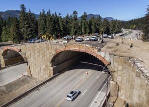
By revamping the highway with wildlife’s needs in mind, officials were able to broker an easement with the U.S. Forest Service to add the additional lanes.

“It’s a win-win. We could improve transportation. We did lose some national forest,” said Garvey-Darda referring to construction of additional highway lanes. “But we can connect the North Cascades and the South Cascades.”

More importantly, I was told that the forest plan provided the basis for the Forest Service position in the negotiations that the North Cascades and South Cascades should be connected.  I can’t find language in the current plan that would clearly address this, but I know the plan revision process was moving towards useful language for connectivity.  Other revised plans are including language that at least provides some intent to participate in highway planning.  This is from the recently revised Kootenai National Forest Plan:

FW-DC-WL-17. Forest management contributes to wildlife movement within and between national
forest parcels. Movement between those parcels separated by other ownerships is facilitated by
management of the NFS portions of linkage areas identified through interagency coordination.
Federal ownership is consolidated at these approach areas to highway and road crossings to facilitate wildlife movement.

This would at least tell a Forest it needs to be a player and give them some leverage.  However, for at-risk species its role is to be a leader, and with nothing more than a desired condition and without identifying any linkage areas in the plan this would not meet any substantive requirements of ESA or NFMA (recovery or viability).  (Similar language in the uniform plan amendment for lynx does apply to mapped linkage areas.)


Zoning in the WUI

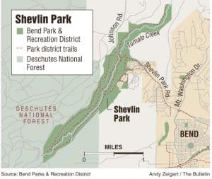
Another example of someone doing something right.  But it’s not the Forest Service; the Deschutes National Forest was listed as an agency that “either had no comment or did not respond to the notice.”  (The forest plan management area for much of the adjacent national forest is something called “other ownership,” but I couldn’t find what that means.)

Developers said they’ll cap the number of homes in the new zone at no more than 187 units — 100 on the north property and 87 on the south. Lots would all be designed to prevent risks of wildfire spreading and protect wildlife habitat, said Myles Conway, an attorney for Rio Lobo investments. Plans also call for a 42-acre wildlife conservation area adjacent to Shevlin Park.

The environmental watchdog group Central Oregon LandWatch, which fought to keep Bend’s urban growth boundary from encompassing the affected areas, “strongly supports” the so-called transect zone, LandWatch staff attorney Carol Macbeth said.

“It’s critical to take a new approach to development in the wildland-urban interface, and the Westside Transect is that approach,” Macbeth said. “It will provide a 4.5-mile first line of defense against approaching fires for developments like Awbrey Glen as fires approach from the west and northwest.”