Forest planning for “sustainable” recreation

A former Forest Service backcountry specialist talks about ecological integrity and increasing human recreation activities, and tries to answer the question of “what is sustainable recreation?”  The 2012 Planning Rule requires plan components “to provide for: (i) Sustainable recreation; including recreation settings, opportunities, and access; and scenic character.”

What is “Sustainable Recreation”? The Forest Service defines it as “the set of recreation settings and opportunities in the National Forest System that is ecologically, economically, and socially sustainable for present and future generations.”

Here’s how it’s done:

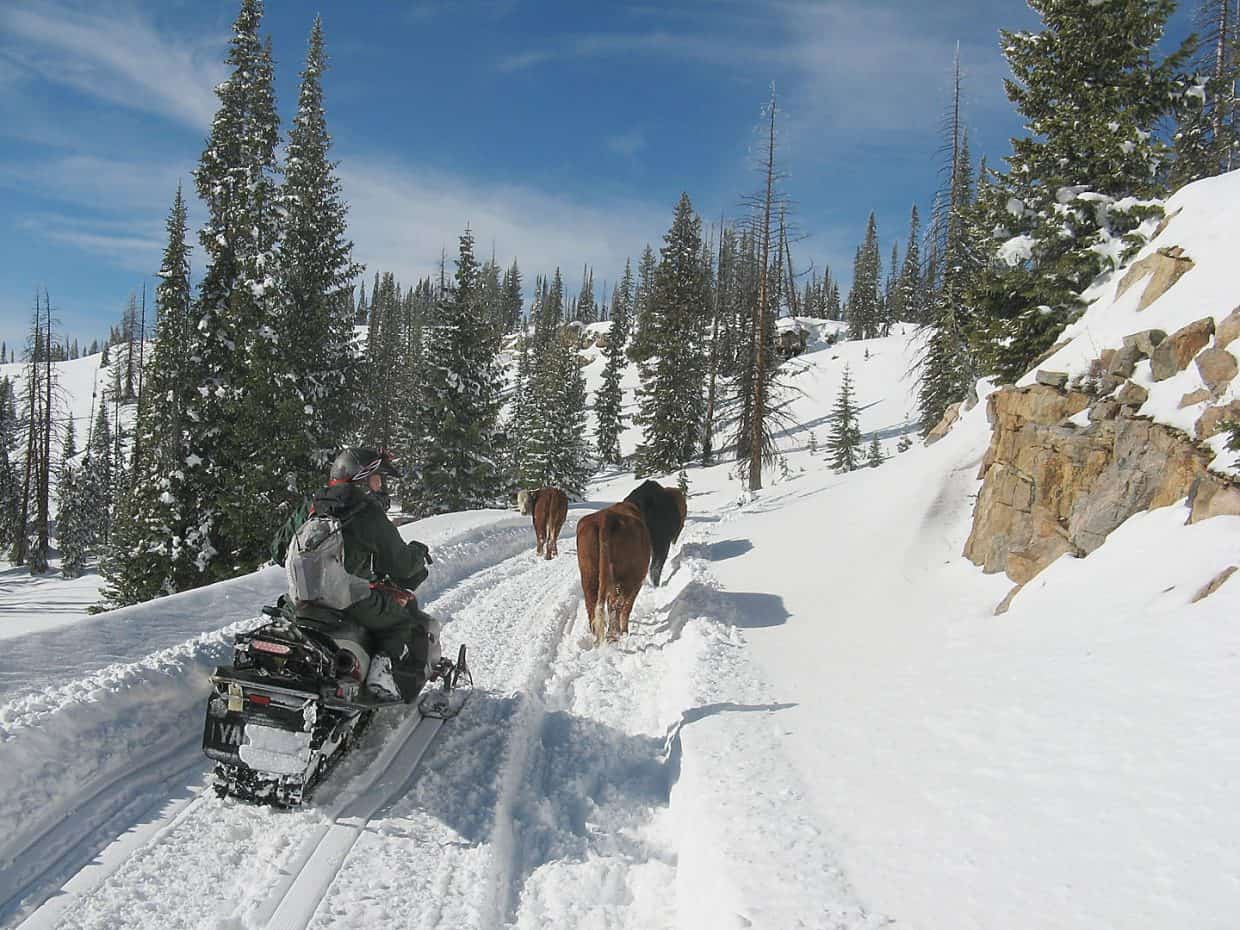
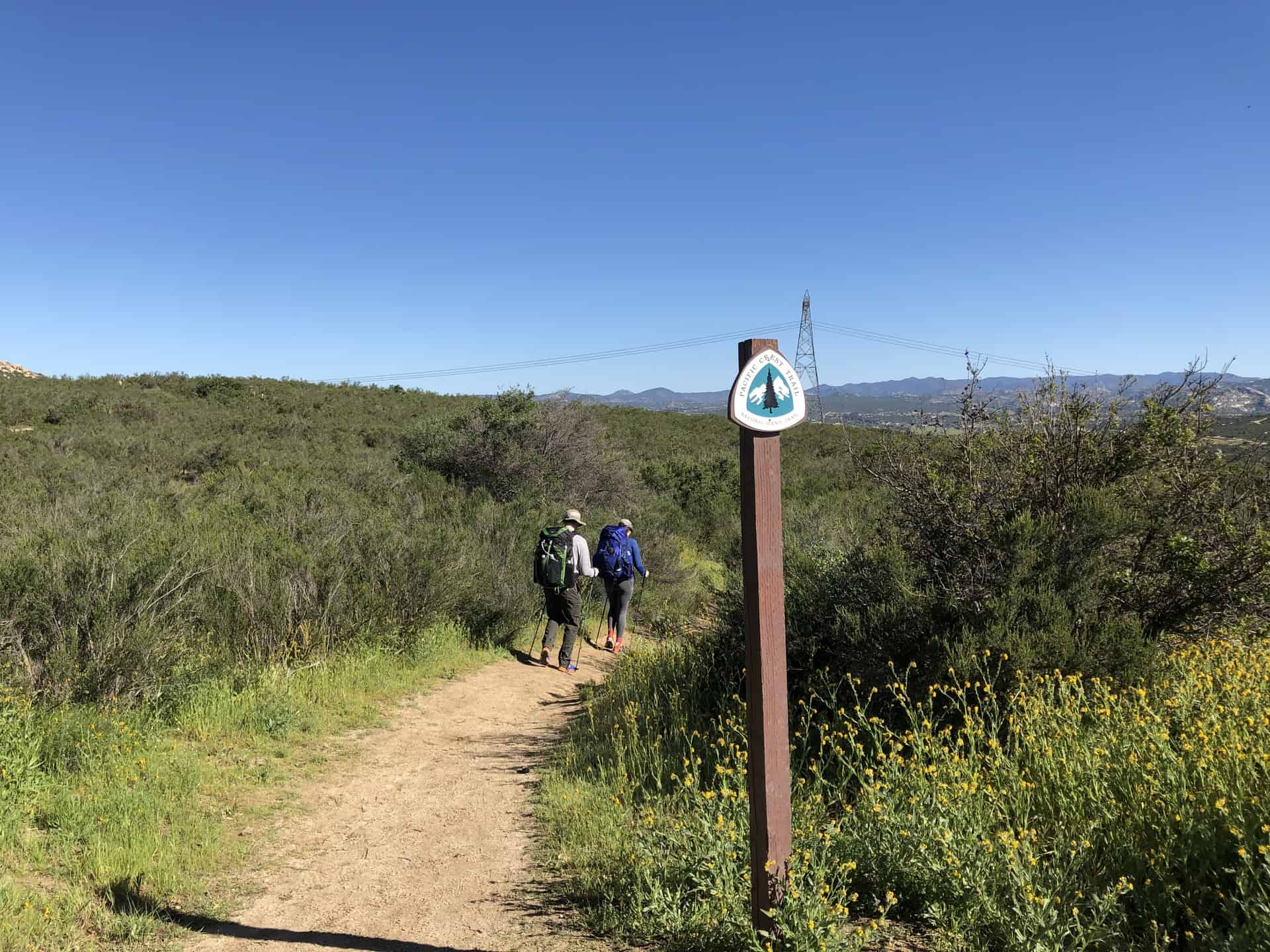
The Recreation Opportunity Spectrum can be used in forest planning to define a desired condition for management within each zone. Indicators and standards are meant to define the tipping point beyond which management action must be taken.
 If the standard for a backcountry area (called “semi-primitive non-motorized” in ROS jargon) is that no more than six other parties are encountered on a typical day, when the encounter rate exceeds that number some action is supposed to take place to return to the desired condition.
It’s a neat framework, but doesn’t always play out as intended on the ground. ROS doesn’t differentiate between a semi-primitive area in the back yard of a town like Jackson or Bozeman and one that’s two hours away.
That seems like a major shortcoming, especially if all areas with a SPNM designation must have the same desired level of semi-primitive non-motorized use.  However, the Planning Handbook encourages “new approaches,” including creating “desired recreation opportunity spectrum subclasses” §(23.23a).
The usual sequence of remedial actions begins with non-intrusive measures like visitor education. If the problem isn’t solved, additional actions are considered.
The Bridger-Teton forest plan is typical in its prescribed sequence of actions, this excerpt taken from its direction on wilderness. The following recreational strategies should be used, listed in descending order of preference:
First Action – Efforts are directed towards information and education programs and correction of visible resource damage.
Second Action – If the first action is unsuccessful, restrict activities by regulation (for example, set a minimum distance between a lakeshore and where people can camp).
Third Action – If the first and second actions fail, restrict numbers of visitors.
Fourth Action – If first, second, and third actions are not successful, a zone can be closed to all recreation use until the area is rehabilitated and restored to natural conditions.
In my experience, outside of designated wilderness and other special areas where specific laws apply, the Forest Service keeps circling around the first action, which isn’t a bad strategy given the continuing need for it in communities where resident turnover is high.  It’s an ongoing need regardless of the often unmet requirement to step up restrictions. But restrictions trigger blowback, as when the Shasta-Trinity National Forest tried to set encounter limits for the wilderness that includes Mt. Shasta.
People basically said they don’t care if it’s crowded—they just want to reach the summit, and a judge agreed with them. On the other hand, those who float the Selway River are happy to wait until they get a launch day shared by no one else. Since everyone is going the same direction at about the same speed, everyone can experience a bit of peace and quiet. So the application of sustainable recreation standards depends on who is using the forest and what they will accept.
And those are the questions that forest planning should be designed to answer.  (Note:  the Bridger-Teton plan has not been revised, so may not be the current state-of-the-art.  Also, I couldn’t find the court case referred to.)  And this must be done against the backdrop of a requirement for ecological integrity.
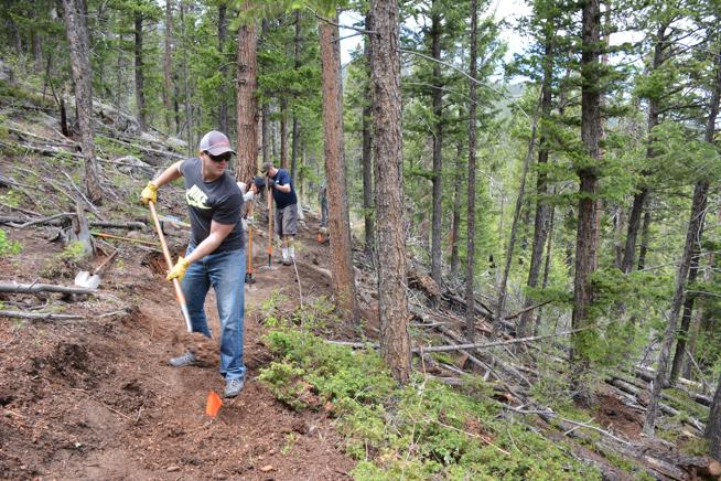
User-built trails and roads are often the opposite of sustainable. They develop incrementally and aren’t designed with soil type, grades and curve radii in mind, or the needs of resident wildlife. The trail system after adoption by the Forest Service usually gets reworked so it doesn’t turn into deep ruts or wash into the creek, but where is the analysis that determines that the trail location is right in the first place?  The trail itself becomes more sustainable, but where do the grouse and elk and owls go?
The adoption of forest plan of components for desired recreational use has effects that must be evaluated during the NEPA process, but rarely does the Forest Service devote much attention to this.
The author describes a common fallacious argument that the Forest Service likes to make about sustainability to avoid controversy:
While the planning rule makes clear that ecological integrity underlies compatible uses in a national forest, the ecological, economical, and social sustainability have since been referred to as a three-legged stool, with all three legs of equal importance.
But if you parse the actual language of the Planning Rule, it is apparent that the ecological leg needs to support more weight (driven by the substantive diversity requirement of NFMA) (my emphasis).
“Plans will guide management of NFS lands so that they ARE ecologically sustainable and CONTRIBUTE TO social and economic sustainability; CONSIST OF ecosystems and watersheds with ecological integrity and diverse plant and animal communities; and HAVE THE CAPACITY TO PROVIDE people and communities with ecosystem services and multiple uses that provide a range of social, economic, and ecological benefits for the present and into the future.

Pike-San Isabel Travel Management History and Comment Period Open: Guest Post from Patrick McKay

The author’s Jeep on a road off Mosquito Pass threatened with closure.
Note from Sharon: as always, different perspectives are welcome in the comments.

Coloradans are blessed with an abundance of public lands in our state, and we enjoy engaging in numerous forms of recreation in our National Forests. From hiking and camping to hunting, fishing, rock climbing, and off-roading, one thing common to all forms of recreation is that they typically involve traveling on Forest Service roads to get there.

While most people give little thought to the roads they travel and consider them an immutable fact of the landscape, few would guess that their very existence is one of the most controversial
arenas of environmental politics. Now we are in the midst of a public process that could have profound implications for every user of public lands in south central Colorado.

On September 19, 2019 the Draft Environmental Impact Statement (DEIS) for the Pike San Isabel (PSI) National Forest Travel Management Analysis was released, commencing a 45 day comment period that runs until November 4. This document represents the culmination of a long and contentious process that will decide whether or not to close hundreds of miles of roads to the public or leave them open for future generations to enjoy.

In 2005, the US Forest Service adopted a new Travel Management Rule which overturned decades of management practice for Forest Service roads. Under the new rule, only routes specifically designated on official Motor Vehicle Use Maps (MVUMs) would be open to motorized travel by cars, four-wheel-drives, ATVs, dirt bikes, etc. Previously routes had been presumed open unless designated and signed as closed. The new rule was devastating to motorized recreation in National Forests, with some forests closing upwards of 90% of existing routes in the process of implementing it. Between 2007 and 2010, the Pike San Isabel National Forest completed its initial round of route designation and published MVUMs for its six ranger districts.

In 2011, five environmental groups including the Wilderness Society, Quiet Use Coalition, Wild Earth Guardians, Rocky Mountain Wild, and Great Old Broads for Wilderness filed a lawsuit against the Forest Service alleging that the PSI improperly added 500 miles of motorized routes to the MVUMs without conducting a proper environmental analysis under the National Environmental Policy Act (NEPA). Many of these routes pre-dated the 1984 Forest Plan or were lawfully created during the time when the Forest was managed as open to cross country travel, and were grandfathered in without specific analysis. If the Plaintiffs’ challenge was upheld, it could have called into question every other travel plan that similarly grandfathered routes.

Motorized advocacy groups including the Colorado OHV Coalition, Trails Preservation Alliance, and Blue Ribbon Coalition intervened in the lawsuit in order to defend off-road vehicle trails that had long been enjoyed by their members. In 2015 the lawsuit ended in a settlement agreement where the Forest Service agreed to conduct a new travel management process and environmental analysis for every motorized route in the PSI. After a scoping period in 2016 and three years of internal analysis, the Forest Service published the DEIS in September. It includes five alternatives labeled A – E, which would close between 3% and 50% of all existing motorized routes in the PSI. The final plan adopted by the Forest Service will be a combination of these alternatives in a modified Alternative C (the Preferred Alternative), with changes made in response to public comments.

While motorized off-highway recreation will be hit hardest by any route closures, every user group will potentially be impacted by them. For example Alternative E would close over 50% of
all motorized routes in the PSI, including numerous major thoroughfares, campgrounds, and hiking trailheads. It would close the only roads accessing all three main trailheads of the Lost
Creek Wilderness as well as those to several popular 14er trailheads. While that is unlikely to happen, the future of where people will be allowed to drive to camp, hike, or engage in off-
highway recreation all depends on the outcome of this process. While Alternative C is fairly reasonable from a motorized perspective, there are still a number of popular 4×4 trails which would be closed and whose loss will be a painful blow to the off-roading community. These include Twin Cones Road above Kenosha Pass and a number of scenic mining roads around Alma and Fairplay, as well as numerous spur roads used for dispersed camping.

The biggest flashpoint will be the roads in Wildcat Canyon (aka “the Gulches”) along the South Platte River north of Lake George. Most of these roads were temporarily closed after the
Hayman Fire in 2002 and underwent a bitterly contested travel management process in 2004. That process ended in the Forest Service agreeing to reopen them in principle but attempting to
turn over management responsibility to the affected counties. Teller County obtained easements and reopened its portion of the roads to the public by 2009. After two of its easement applications were lost by the Forest Service, Park County abandoned the effort to reopen its half of the Gulches trail system and those roads remain closed and in limbo. It will be up to the Forest Service to decide their final status in this process, with motorized users calling for them to be reopened and environmental groups demanding they be permanently closed in order to avoid environmental impacts to the Platte River.

Ultimately, this travel management process will be a bitter clash between those with diametrically opposed views of acceptable uses of public lands. Motorized users trying to defend the limited access they have now against further closures will face off against those who refuse to tolerate any level of motorized access to National Forests and who want almost all Federal lands managed as Wilderness. Forest Service officials are left with the unenviable task of striking some kind of balance between these two positions. The final outcome will almost inevitably be challenged in court, continuing the cycle of endless litigation that has characterized travel planning under the Travel Management Rule since its adoption.

If there is an area of the Pike San Isabel National Forest you care about, you may submit a comment before November 4 on the project website here. There will also be public meetings held in Denver, Colorado Springs, Pueblo, and Salida the week of October 8 – 11. Participation in the comment period is vital to ensure your voice is heard and the areas you love remain open in the future.

Patrick McKay is a Colorado native from the South Denver area who enjoys Jeeping, hiking, camping, and skiing in the Rocky Mountains. He is a former attorney currently working as a software developer and is passionate about preserving access to public lands for all forms of recreation.

Mountain bikes – off the beaten path

Nobody bit on my late comment on the Tenmile South litigation (Helena-Lewis and Clark National Forest):

One piece of this decision is new to me: “My decision also includes restricting bicycle travel to system roads and trails.” Prohibiting bikes off-trail seems obvious, but it was criticized, and I wondered if this is commonly being addressed in travel planning.

I know there’s some readers with opinions on this, so I’ll try again.  Here’s the same decision on the Arapahoe-Roosevelt National Forest, captured in this headline “New rule in Arapaho National Forest limits bikes to designated trails:”

On Monday, the Forest Service announced that bicycles will no longer be allowed off designated trails and roads in the Sulphur Ranger District, which covers the Arapaho National Forest. The restriction applies to all kinds of bikes in both the summer and winter.

“A key aspect of this project is to balance all these trail improvements with the conservation of wildlife habitat, watersheds and other natural resources we value,” Ranger Jon Morrissey said. “Part of finding that balance is curbing the proliferation of user-created routes and keeping the impacts to the trails system so that wildlife and other resources can thrive.”

Off-trail use is how user-created trails are created, right?   (And I’ll argue it takes a lot fewer bike users – like maybe one – to create a trail than foot users.)  And the impacts of user-created trails seem like they would be not wanted on public lands just about everywhere.  Yet there is no specific requirement for the Forest Service to address this problem like there are regulations for motorized use that require travel planning and designation of routes.  So while there are designated system trails, there is apparently no requirement for bikes to stay on them.  Should there be a national prohibition?  Should forest plans identify areas where off-trail use is a desired condition?

When the government wants to take something away

These two stories about national forest management demonstrate how hard it is to change or eliminate existing uses, but the Forest Service is trying.  In both cases, there is outside pressure to do so.  In one, a lawsuit was required to force the Sierra Nevada national forests to complete travel management planning for over-snow vehicles that was required in 1972.  In the other, the Malheur National Forest is trying to implement changes in grazing required by the listing of salmon and bull trout under ESA, subsequent forest plan direction, and current oversight by the regulatory agencies.  The ranchers and snowmobile users are of course not happy.  (But some non-motorized winter users are.)

Black Hills ghost trails come alive

Two existing but unauthorized recreational trails will be considered for inclusion in the Black Hills National Forest’s official non-motorized trail system. But the trails were apparently blazed by users rather than Forest Service officials, and neither trail is considered part of the forest’s official trail system.

Just two years ago, the then-ranger of the Forest’s Mystic District, Ruth Esperance, threatened to criminally prosecute builders of unauthorized trails. The threat provoked a backlash among trail users, especially in the mountain-biking community, who accused forest officials of longstanding inaction on proposals for new trails.

In other words, they got tired of waiting and just decided to do it themselves, and the Forest Service is about to sanction that.  Meanwhile, four other proposed trails were set aside for now by Forest Service officials, who considered a total of six proposed trails as part of a new trail-proposal process that was created in August.  They were not approved because of unacceptable impacts.

Van Every identified numerous problems with the Storm Mountain and Victoria Lake trails. “Issues include routes through documented cultural sites, crossing private property, permitting bicycles on the historic Flume Trail where they are currently not authorized, crossing a major highway, fence crossings in the Foster Gulch area, lack of parking, and potential conflict with big game winter range,” Van Every wrote…  Furthermore, Van Every wrote, the Paha Sapa trail goes through the Norbeck Wildlife Preserve, where trail miles are limited by the Black Hills National Forest’s management plan.

For the two trails that were advanced for further review, several more steps in the process remain, including environmental reviews in accordance with the National Environmental Policy Act.

Well, this kind of points out the problem with this approach – these trails are already there and impacts have already occurred.  The reason the Forest Service doesn’t “just do it” is because there are resources they are charged with protecting that they are required by law to consider BEFORE they decide to do it.  But here is a great way to shortcut the process, and ignore legal requirements; just look the other way. The users could have funded the environmental analysis needed to proceed, but instead extra-legal “self-help” is apparently being rewarded.

Maybe this new process of “build it, then ask for it” will become the model for other places where the Forest Service doesn’t act fast enough on trails or other developments (or maybe even where they’ve already said “no”).  Maybe national forest neighbors (or their governments) will start using this approach to cut down trees on public lands that they consider a fire risk, or maybe they’ll burn them.  (This actually reminds me of the “shovel brigade” that rebuilt a Forest Service road in Nevada after a flood, which damaged bull trout habitat, but there the Forest Service at least resisted it.)


Travel planning vs RS-2477

In 1866, the Mining Act included this provision (now known as RS-2477):  “the right of way for the construction of highways over public lands, not reserved for public uses, is hereby granted.”  What this means and how it is applied has become an issue with local governments in recent years where federal land managers have wanted to reduce roads or limit access.  It generally means that if a road predates the establishment of a National Forest, the Forest Service can not interfere with valid uses.  The process requires a quiet title action in federal claims court.

Here is a recent battle brewing in Colorado, where one county is actively seeking jurisdiction over 17 roads and trails in three counties, one of the trails being targeted for closure to motorized uses through the San Juan National Forest Travel Plan.  Another county wants nothing to do with it.  Montezuma County believes it has maps that prove its case, but the Forest Service disagrees. Here is their response:

If the information relying on maps is the only county proof that the roads and trails qualify for RS2477 status, then “the basis for the resolution is insufficient,” Padilla wrote.

He said the Forest Service is not against evaluating RS2477 assertions, but that the county bears the burden of proof.

“I know the county believes the converse is true, but that is not supported by current law, policy or regulation,” Padilla stated.

The national forest sees the county’s RS2477 resolution as nonbinding.

Routes currently designated as nonmotorized or are closed for public use will continue to be managed that way until the county validates their assertions through a legally recognized process, Padilla said.

“This means that violators would continue to receive citations,” he said.

Padilla added that there are current cases to support this position, including one in San Juan County, Utah, that involved county commissioner Phil Lyman, who received a ticket for driving an ATV on a nonmotorized route during a protest ride.

Where Dolores County disagrees is whether the Forest Service will “fight it,” which affects the cost side of the ledger for the counties.  I’m not aware that DOJ has ever conceded a RS-2477 case where the land management agency disputed the existence of the right-of-way.  But under this Administration, maybe Dolores County is wrong in thinking they should not “deceive ourselves that routes will just be given to us.”

Ugly Americans get involved in travel planning

“The debate over snowmobile access in the Tahoe National Forest has taken an ugly turn with a spate of emails, social media posts and online comments filled with foul and abusive language.

Several people pushing for more restrictions on snowmobiles in the 800,000-acre forest that straddles the Sierra Crest have been the targets of online abuse.

The problem has gotten bad enough that Forest Service officials disabled a portion of the online comment system when they suspected people used it to target other commenters with nasty emails.”

This is a symptom of a much bigger problem in this country right now, but the problem it causes federal agencies is that they will have to start questioning the results of the public comment process where there is any indication that people have been intimidated from participating.

Forest Service prosecutes mudders

The federal government does go to court sometimes to protect our natural resources, here in North Dakota:

Three men accused of damaging U.S. Forest Service land four years ago while going mudding in the Little Missouri National Grasslands now face criminal charges in federal court.

Five full-sized pickups got stuck in the mud in the area known as Estes Springs. The individuals involved then got two road graders to try to recover the pickups, but then got the road graders stuck in the wet and muddy conditions.

The area has signs indicating it is National Forest Service land and directing the public to stay on established roads and trails.

Jan Swenson, executive director of the Badlands Conservation Alliance, saw photos of the incident four years ago and said it looked like the pickups had driven donuts in the mud following a rainstorm.

“It is great to see the Forest Service following through,” Swenson said. “It would be encouraging to see other government entities follow through on enforcement issues as well.”

The next extinction on the national forests

Based on this year’s winter survey, the federally endangered South Selkirk mountain caribou herd may be down to three individuals – all females.  That would not be good for continued viability of the species on national forest lands.  We can try to blame Canada for what’s happened to this cross-boundary herd, but, “The mountain caribou have struggled as old growth forests have been thinned by logging and other industrial activities, George said. With thinner forests the caribou have become more susceptible to predation.”  There has been a lot of that on the Idaho Panhandle and Colville national forests over the years, though maybe not recently.  However, as recently as 2007, the Forest Service lost a lawsuit brought because of their failure to protect caribou from snowmobiles.

It would be hard to say that national forest management has had nothing to do with their current status.  Mark Hebblewhite, a Canadian wildlife biologist at the University of Montana and a science adviser to the Canadian government put it this way:

“It’s game over …  The functional loss of this herd is the legacy of decades of government mismanagement across caribou range.  It is completely unsurprising. Bad things happen to small populations.”

Meanwhile, north of the border, the boreal woodland caribou may become Canada’s spotted owl, as conflicts with logging are driving it towards extinction.   A letter from the Alberta government to Ottawa said “now is not the time to impede” an economic recovery currently underway in Alberta.  Maybe when there are three females left.

Wyoming Public Lands Initiative and the Bridger-Teton National Forest

“In early 2016 the Wyoming County Commissioners Association (WCCA) organized the Wyoming Public Lands Initiative (WPLI).  The WPLI is a collaborative, county-led process intended to designate WSAs as wilderness, multiple use, or other management.  The result will be one state-wide legislative lands package that is broadly supported by public lands stakeholders in Wyoming.”

It always makes me a little nervous when a local “collaborative” (or local government) feels empowered to dictate federal land policies (especially where, as in this case, there is a county plan that purports to “guide … the management of public lands” – implicitly federal lands).  On the other hand, it’s always helpful to land managers if those with opposing views can work out and recommend something they all agree on.   With wilderness designation decisions there is the added layer of Congress having to take a national look before approving a decision.  In this case there are also national conservation groups represented in the collaborative, as well as local ones.  But there is also a lawsuit by other conservation groups, and apparently someone on the other side ran to the local Congresswoman who is meddling, so the county commissioners are asking for a “time-out.”  Here’s the latest.