Sleeping With the Enemy?

high-intensity-burn-web

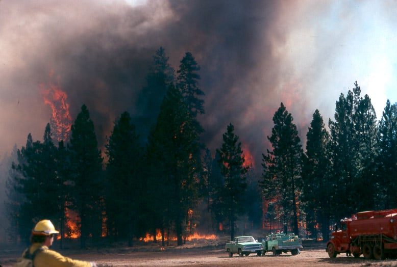
Timber industry people who don’t trust forest collaboration believe that those of us who participate in collaboratives are sleeping with the enemy. Environmentalists who would rather sue than participate in collaboratives think that environmentalists who collaborate with us are sleeping with the enemy. So it’s unanimous. We’re sleeping with our enemies. I don’t care what our critics think. Collaborative groups, ours included, are solving political problems that should never have become political problems, and those problems are the reason why our forests are dying and burning before our very eyes. So if you really want to know what collaboration is all about, it’s about protecting forests from the ravages of nature, not just for our benefit, but also for the benefit of future generations.

Duane Vaagen, Chief Executive Officer
Vaagen Brothers Lumber Company, Colville, Washington

http://www.evergreenmagazine.com/forest-collaboration-in-northeast-washington-part-1-duane-vaagen/

Larry’s note: Sent to me from a reader, this points out the, maybe, necessary mistrust at this part of the collaborative journey. We need all sides to embrace full transparency, so that the public at-large can more accurately form a better-educated opinion of the compromises that might work, for those site-specific conditions. I do think that the tables are turning, in favor of more active management and stewardship. I do think this summer’s fire season might convince a few more people, too.

Rim Fire Images

The media does like to sensationalize events like the Rim Fire, often implying that the lands have been “destroyed”. The Rim Fire is so huge and burned across so many differing kinds of vegetation that you cannot summarize too much. Even my own “sampling” from the access roads doesn’t cover very much of the impacts and effects of a 250,000 acre wildfire.

Much of the wildfire burned in plantations generated from previous wildfires. Here is an example of one of those plantations that wasn’t thinned. I can see why it wasn’t but, maybe a “pre-commercial thinning” kind of task could have been included into one of the other commercial plantation thinning projects that I worked on, back in 2000.

P9206850-web

In the same area were blocks of land that were left for “Mother Nature”, after the early 70’s Granite Fire. Here is what a 40 year old brushfield looks like. Those blocks are choked with deer brush, whitethorn and manzanita, with very few conifers, and fewer oaks than the “natural stands” (as they called the unburned portions).

P9206847-web

As you can see, sometimes there is a fine line between a total plantation loss and one that has survived a wildfire. This is one of the thinned plantations, near Cherry Lake.

P9206842-web

Here is another example of an “old growth” brushfield. While this one didn’t burn much, there are many examples of them burning at moderate to high intensities. Looking at Google Maps, I can find examples where the flames from the brushfields were pushed into the thinned plantations. The Forest Service should be treating those old brushfields with prescribed fire, instead of “whatever happens”.

P9206833-web

This unburned stand, within the fire perimeter, is a good example of the work we did back in 2000. I don’t really know of any other reason why this large patch, near Cherry Lake, didn’t burn

P9206819-web

The Clavey River, long-cherished by the local eco-community, acted like a conduit for the Rim Fire, as it burned so many acres in just one day. However, you can see that the intensity and damage is rather minimal. There is a fork in the river, down there, and the main fork of the fire went up that way, finding more conifers to burn. (It also found the big block of Sierra Pacific Industries lands.) I found it very interesting that the isolated pockets of Douglas-firs had very high mortality, but only a low-to-moderate intensity.P9206804-web

Here is one of those pockets, alongside the Clavey River. In the past, this kind of pocket would be thrown into a large helicopter salvage project.

P9206800-web

Service Contract Re-visited

In my last adventure, I decided to pass through an area of the Tahoe National Forest, where I worked in 1996 and 1997. During that time, I worked on fire salvage, blowdown salvage, insect salvage and roadside hazard tree projects. There was also this Service Contract, which reduced fuels without cutting trees over 9.9″ dbh. The logger had three varied types of cutting machines, each of them with their strengths and limitations. He was a crusty old guy, who didn’t like the Federal “oversight” of his work.

P9306380-web

I usually liked to change these loggers’ perception of what inspectors do. He wasn’t used to getting “written up” for doing good work but, he was still quite wary of me. I once caught him damaging the bark of a leave tree with his machine, then getting off it, and applying some dirt to the wound (to hide it). As he was getting back to his seat, he saw me. I gave him the “naughty, naughty” hand signal, and walked over there. I waited to see how he would react to getting caught. Surprisingly, he kind of hung his head, and was quiet, for once. So, I told him that there is an acceptable level of “damage” in this kind of work and he wasn’t anywhere near close to it, yet. I think our relationship changed, a little, after that agreement.

P9306391-web

One of the keys to success was the ability to do a cool prescribed burn. All too often, fuels are still too thick and the burn is a bit hotter than the residual trees can stand. In this case, the firefighters did well in achieving a nice, cool and effective burn. On the west-facing slopes, the brush has grown back, somewhat. That is to be expected, and will continue, until it is shaded out.

P9306396-web

As far as resilience to fire and drought, it is pretty clear that the spacing is very good. The brush looks like it can be burned safely, on a regular basis. The pines also seem to be quite healthy and vigorous. Keep in mind, this area along Highway 89, in the eastside pine zone, is in a rainshadow east of the Sierra Nevada Crest. There are some western junipers up on the ridgetop, and the Nevada desert is 15 miles away.

P9306381-web

The Tahoe Basin

Lake Tahoe would probably be a National Park, by now, if the Comstock Lode had never been found. There was clearcutting right down to the lakshore, for mining timbers, in the silver mines. Incline Village was named for the switchback road that transported logs to a flume that went all the way down to the Washoe Lake area, thousands of feet below.

Today, there is very little “logging” next to all that blue Tahoe lake water. Newspapers especially like to describe the basin as “pristine”, apparently not knowing the actual meaning of the word.

P9123090-web

Much of the Lake Tahoe Basin is “de facto” Wilderness, with very little management happening, even when wildfires occur. Residents seem to be in denial about wildfire issues, not remembering the last drought that decimated their forests. However, it is easy enough to see the results of the last bark beetle infestation, in the form of accumulated fuels far beyond what is “natural”. Many areas of forest mortality were left “to recover”, on their own. Well, sometimes “recovery” takes decades or even centuries, as long as humans don’t intervene. That might also include multiple wildfires, opening the ground to accelerated erosion and having clarity-declining sediments flowing into Lake Tahoe.

P9123100-web

Ironically, the lake’s level isn’t all that far down, thanks to the lobbying of lakeshore land owners, putting pressure on water regulators. That can only go so far, as Reno area interests need more water to keep growing and thriving. We’ll just have to see how the battle goes, as the Truckee River drops further and further.

Dry Sierra Winter

I recently drove over California’s Carson Pass and spent a day in the Lake Tahoe Basin. The weather was good, so I decided to save some money and camp out (!) for two nights (and spending $42 for a night in Reno).

My day at Tahoe began encased in ice, as moist and cold air flowed down the canyon I was camping in. I quickly gathered my frozen gear and stuffed it into the car, making my way to Truckee, and precious morning coffee. From there, I drove down Highway 89, which was very familiar to me, as I used to bicycle, hitch hike and drive it, many times a week, when I lived there, in the 80’s. I continued along the west shore of Lake Tahoe, to reach my first planned stop at Eagle Rock. I had last climbed it in the mid 80’s, and I didn’t know there were now two trails to the top. It was still a bit icy on top but the amazing views sure hadn’t changed. Eagle Rock is a post-glacial volcanic plug, where Blackwood Canyon meets Lake Tahoe.

It appears that the bark beetles haven’t yet arrived in Tahoe yet but, they sure are knocking on the door. I did see bug patches in the southern part of the Eldorado. I heard about one landowner who had 42 bug trees on their property.

P9123021-web

I later visited the famous Emerald Bay, and you will see pictures of that in another post.

Along Highway 88, on the Eldorado National Forest, they have this interesting project being worked on, during the winter. I’m guessing that units have to find other ways to spend their timber bucks since litigation has returned diameter limits to the old unreasonable sizes imposed in 2000. It looks like this project is a highway strip, intended to be a quasi-fuelbreak. It does appear that some trees up to 9″ dbh were taken out, for spacing. There are going to be a ton of tiny piles to burn, and the California Air Resources Board has not been kind to the Forest Service in granting waivers on No-Burn days. And, yes, the piles are covered with burnable material that will keep the pile dry, so ignition will be easy.

P9102965-web

Can we start calling these things “Big Thin Lies”? It is what people see, and they think all forests look like these cleanly thinned and piled forests.

Fall in the Forests

I had the pleasure of doing forest inventory work on the Sumter National Forest, 12 years ago. I had to dredge up all that “brain sludge” from Dendrology class, to identify eastern hardwood species. Some of those stands were rather uniform pine stands, as replanted cotton fields. In the “drains”, as they are called, you see great variety in hardwoods. I found 40 different hardwood species, with 20 of them being oaks. Another difference from western National Forests is that they still use metes and bounds to designate boundaries. I did enjoy the fabled “Southern Hospitality” but, I never did develop a taste for grits and red-eye gravy, and BBQ in South Carolina is a very different kind of animal.

The fungi was abundant and diverse, due to the warm and wet conditions.

fungi1-web

Urgent Action Needed to Save Sierra Forests

This viewpoint shows more of the reasons why the desire to have larger and more intense wildfires, in the Sierra Nevada, is the wrong way to go.

In this picture below, fire crews were run out of this stand, and back into the “safety zone”, on this fire I worked on, back in 1988.

campbell_fire1-web


http://www.sacbee.com/2014/09/28/6737076/viewpoints-urgent-action-needed.html

Air quality the past two weeks has been several times worse than some of the most polluted cities in the world due to smoke from the King fire. Last year’s Rim fire emitted greenhouse gases equivalent to 2.3 million vehicles for a year.

Also, the lost habitat and recreational opportunities from major fires like these are significant. It is not an exaggeration to say that virtually all Californians are affected when these “megafires” occur.

The report points out that wildfires are getting larger and burning at higher intensity than ever before. The Rim fire burned at nearly 40 percent high intensity – meaning virtually no living vegetation is left – covering almost 100,000 acres. More acres have burned in the first 4½ years of this decade than in seven decades of the last century.

What can we do about it?

The main bottleneck in treating more acres is in implementation. The Forest Service is unwilling to increase the size of its Region 5 timber management staffs. They use some of the usual excuses, some of which are beyond their control but, not all of those issues are really significant, looking at the big picture. Yes, it is pretty difficult to implement extremely-complex plans when you are constantly training new temporary employees, hired right off the street.

UC Berkeley Gets it Right, and Gets it Wrong

A Cal-Berkeley fire scientist shows his unawareness of current Forest Service policy but, his other ideas favor active management of our Sierra Nevada National Forests.

Canopy2-web

The situation is compounded by the gridlock between environmentalists and commercial foresters. The former favor thinning, but they want all logging plans to leave the larger trees, particularly those with trunks over 30 inches in diameter. But the timber companies maintain it is necessary to take a significant number of bigger trees to fund thinning and restoration programs.

Stephens generally favors the enviro position. Landscape-scale wildfire damage is driven by vast acreages of small-diameter, closely-packed trees, he says. By leaving the larger trees, the essential character of a natural forest can be maintained, even accelerated. And he thinks markets can be found for products produced from thinned, scrawny trees.

http://alumni.berkeley.edu/california-magazine/just-in/2014-09-26/brush-flame-king-fire-narrowly-misses-proving-fire-prevention

Of course, there has been a ban on the cutting of trees larger than 30″ dbh, since 1993. Ditto for clearcutting! These are two big hot-button issues for most “conservationists” but, there are still people out there who want timber sales banned, altogether. There are others who would love to go back to the Clinton rules of the Sierra Nevada Framework, which would shutdown much of Region 5’s timber management programs. A 22″ dbh tree, underneath a 36″ dbh tree cannot be considered “scrawny”.  Generally, most of the thinned trees are in the 10-18″ dbh size, averaging about 15″ dbh.

Throwback Thursday Hits NCFP!

After the “Siege of 1987”, and 43 wildfires on the Hat Creek Ranger District, in three days, the Lost Fire burned up this forest up on the Hat Creek Rim. Even without terrain effects, this fire raged through the forest incinerating everything in its path. There is an eerie beauty in this picture, reminiscent of an Ansel Adams monochrome image.

high-intensity-burn-web

Today, those forests are growing back, after a big reforestation program, and it appears, a subsequent thinning. Here is a Google Maps view of that area today.

https://www.google.com/maps/@40.8027893,-121.4002792,862m/data=!3m1!1e3?hl=en

Already this summer, there has been 3 large wildfires on this Ranger District. It is mostly a dry “eastside pine” forest, requiring trees to be thinned and crowns separated. It appears that the Forest Service is finally seeing that early thinning is key to restoring forests. In the past, it always appeared that they were “gambling” on waiting for the trees to get bigger (and more profitable), before managing their plantations.

More Rim Fire Pictures

All too often, once a firestorm goes cold, a fickle public thinks the disaster is over with, as the skies clear of smoke. In the situation of the Rim Fire, the public hasn’t had much chance to see the real damages within the fire’s perimeter. All back roads have been closed since the fire was ignited. Besides Highway 120, only Evergreen Road has been opened to the public, within the Stanislaus National Forest.

From my April trip to Yosemite, and Evergreen Road, this unthinned stand burned pretty hot. This would have been a good one where merchantable logs could be traded for small tree removal and biomass. Notice the lack of organic matter in the soil.

P9202313-web

Sometimes people say there is no proof that thinning mitigates fire behavior. It’s pretty clear to me that this stand was too dense and primed for a devastating crown fire. I’m guessing that its proximity to Yosemite National Park and Camp Mather, as well as the views from Evergreen Road have made this area into a “Park buffer”. Now, it becomes a “scenic burn zone”, for at least the next few decades.

P9202306-web

There is some private land along Evergreen Road, which seem to have done OK, at least in this view. Those mountains are within Yosemite National Park. Sadly, the media likes to talk about “reduced burn intensities, due to different management techniques”, within Yosemite National Park. Only a very tiny percentage of the National Park lands within the Rim Fire have had ANY kind of management. Much of the southeastern boundary of the fire butts up against the Big Meadow Fire, generally along the Tioga Pass Road (Highway 120). Additionally, much of the burned Yosemite lands are higher in elevation, as well as having larger trees with thicker bark. You can also see that there will be no lack of snags for the blackbacked woodpecker. Can anyone say, with scientific sincerity, that over-providing six years of BBW habitat will result in a significant bump in birds populations? The question is really a moot point, since the Yosemite acreage, alone, does just that.

P9202301-web

People have, and will continue to compare the Yosemite portion of the Rim Fire to the Stanislaus National Forest portion, pointing at management techniques and burn intensities. IMHO, very little of those comparisons are really valid. Apples versus oranges. Most of the Forest Service portion of the fire is re-burn, and there is no valid Yosemite comparison (other than the 2007 Big Meadow Fire). It has been a few months since I have been up there, and I expect that there are plenty of bark beetles flying, and the trees around here have no defense against them, with this persistent drought. Everything is in motion and “whatever happens” is happening.