The Great Falls Tribune and Helena Independent Record recently teamed up (whether they knew it or not) to present a fairly cool multi-media education about the Forest Service’s “let it burn” policy as it applies to the Bob Marshall Wilderness complex and this summer’s Red Shale wildfire.
Not surprisingly, the Forest Service is finding that following nearly 30 years of following such a policy in the Bob Marshall Wilderness complex, fuels have been reduced, wildlife habitat has been created and US taxpayers have enjoyed significant wildfire suppression cost savings (again, whether they know it or not).
First, I highly recommend watching this short video from the Great Falls Tribune. Mike Munoz, Rocky Mountain District Forest Ranger on the Lewis and Clark National Forest is interviewed and gives some of the recent wildfire history in the Bob Marshall, as well as some of the rationale and justifications for the Forest Service’s “let it burn” policy. The video includes some pretty cool GoPro footage from high about the Bob Marshall, so enjoy some of those images.
Next, Eve Byron of the Helena Independent Record has a more extensive story, parts of which are highlighted below.
Twenty-five years ago this month, the Canyon Creek fire roared out of the Scapegoat Wilderness after slowly burning unfettered for more than three months, deep within the mountains, under part of the so-called “let it burn” U.S. Forest Service policy.
Eventually, the Canyon Creek fire burned across more than one-quarter of a million acres, forced the deployment of shelters by more than 100 firefighters and threatened the town of Augusta.
The local firestorm of criticism over the Forest Service’s handling of the Canyon Creek fire lasted even longer than the conflagration. But valuable lessons were learned, and this summer, as the Red Shale fire was allowed to burn relatively unchecked through the wilderness, it did so with little fanfare.
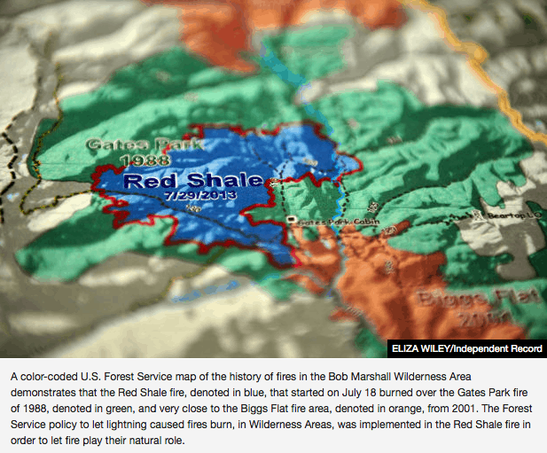
Brad McBratney, the fire staff officer for the Helena and Lewis and Clark national forests, and Rocky Mountain District Ranger Mike Munoz smile at questions about various firefighting tactics used by the Forest Service, well aware that the public typically has a limited understanding of how decisions are made as to whether to try to extinguish wildfires in wilderness areas or let them burn. They pull out two yellowed documents from the early 1980s, which foresters have used in the ensuing decades to put policies into practice on the ground, and half a dozen maps showing how fires have shaped the 1.5 million-acre Bob Marshall Wilderness Complex landscape since then.
“In 32 years, we have seen some significant fire activity on the landscape,” Munoz said….
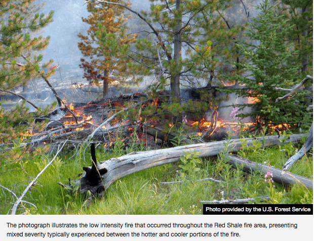
McBratney and Munoz point toward this summer’s Red Shale fire as a textbook example of fire management, even though it is still burning after being started by lightning on July 18, about 35 miles west of Choteau. The fire has spread over 12,380 acres in a typical mosaic pattern, burning trees in one area but leaving others standing. Most of the burned area is within the footprint of the Gates Park fire, which ended up totaling about 52,000 acres.
They do more up-front planning, which includes examining various long-term scenarios. They get daily briefings on weather. More resources are in place — both people and equipment — if it’s needed. They map using satellites and infra-red radars. The develop models on where the fire is expected to burn and revisit those models regularly to tweak them.
Public information officers posted daily updates on a fire’s size, location and the number of resources assigned to it in Choteau and Augusta. There’s even an “app” that allows cell phones to scan it and go directly to the online “InciWeb,” a national incident management website that posts fire information, to learn more about the Red Shale fire.
Even if they’re not actively trying to extinguish the flames, they still use helicopters to drop water to cool the blaze and try to direct it away from some areas. They’ve wrapped historic cabins with fire-resistant materials and installed sprinklers as protective measures.
At the height of the Red Shale fire, about 25 people were assigned to it, including about 10 people on the ground. Today, four people are watching the fire, which is mainly smoldering after recent rains and cooler fall temperatures.
Today, after 100-plus fires in the Bob Marshall Complex have burned hundreds of thousands of acres since 1980, there’s less fuel to add to the fires. Munoz points to the Red Shale fire map, which shows how it burned to the edge of the 2001 Biggs Flat fire, then stopped without human intervention.
In addition to the natural fires within the wilderness area, forest officials have used prescribed burns to remove fuels outside the boundaries, with the hope that will make it easier to catch a fire that makes a run toward private property.
They’ve also worked on building relationships with local and state firefighters. McBratney is a member of the Augusta volunteer fire department, and Stiger said that during the recent fire season local volunteers meet weekly with state and federal representatives to talk about potential issues.
Good post. I recall that in the 1940’s on the Texas National Forests, the fire staff/asst supervisor suggested that wildfires on areas scheduled to be prescribed burned should be allowed to burn. He was chastised by the Regional fire staff for such heresy. Times do change.
However, the West Fork Complex fires are a template for how not to manage Wilderness fires. There are better ways and times of the year to burn a bunch of protected snags. I’d like to know how much personnel and equipment was dedicated to the Red Shale fire. I really doubt that “Let-Burn” is “sustainable” in drier years. *smirk*
RE: “I’d like to know how much personnel and equipment was dedicated to the Red Shale fire.”
Perhaps, Larry, your *smirking* caused you to miss this from above
“At the height of the Red Shale fire, about 25 people were assigned to it, including about 10 people on the ground. Today, four people are watching the fire, which is mainly smoldering after recent rains and cooler fall temperatures.”
Also, was it not a “drier year” in Montana and throughout much of the West? Certainly nobody could claim 2013 was a wet year, at least not around here. Local news reported that Missoula had the highest number of 90+ temperature days in recorded history.
Also, please provide some context and evidence to back up your claim that “the West Fork Complex fires are a template for how not to manage Wilderness fires.” Here’s in the official InciWeb link to the fire: http://inciweb.org/incident/news/3436/
After nine days, one of the fires was at a safe and highly manageable 150 acres. According to Inciweb, the adjectives of fire growth and terrain were both “extreme”, and officials wanted to burn more than just 150 acres, of dead Wilderness. If the fire occurred in October, then it would have been more appropriate to let fires burn. I guess it is kind of “inconvenient” that lightning fires occur in the middle of fire season, eh? Decision-makers, in these cases, should be held accountable for their mistakes. Fire-use doesn’t follow NEPA, and the risks to people are much higher than thinning projects and salvage sales. It sure seems ripe for an attorney to force “Let-Burn” to follow NEPA, then spend the following decade litigating against attempts to do so. Sign me up!!
Thanks for this, Matthew.
Fire use reminds me of the Shoshone so I went hunting on the internet to remind myself of why this might be the case, and found this Lessons Learned piece about the Shoshone and High Reliability Organizations which some might find interesting here. You can also find a wide variety of other information available to the public.
My point is that if the FS gets better at fire use, one of the reasons is the Lessons Learned Center. Here’s a shout-out to them!
Maybe Andy should send them some beer ;)?
These kind of stories always remind me of the famous Vietnam quote, “We had to destroy the village to save it.” Yes…the best way to prevent fires in wilderness areas is to let it burn first. That’s the reason my “Type II incident commander” relative said he always looks for regen clearcuts AND old burns to tie his fire lines into. The reason the regen clearcuts and old burns don’t like to burn are very similar. Surface fuels treatments and young growth. Young trees have a much higher moisture content than old forests with the available precip. Less cubic volume/acre means higher individual tree moisture content. My gosh…the grass in the photo was positively green and lush.
Since there is NO more timber management on USFS lands, it doesn’t surprise me that the USFS is “promoting” these Let it burn fires in Lieu of timber management …and I don’t have any problem with them in wilderness and even “to steep to thin” non-wilderness , but I doubt if the public knew how many acres had burned in the wilderness, that they would endorse it for the “non-wilderness” where 98% of their Recreational Visitor Days are spent. Eve Byron of the Helena IR is a good reporter, but I wish she would ask the USFS how many acres in the Bob Marshall has burned in the last 25 years. What percent of the “forested acreage” has burned. In a past comment, I mentioned that 35% of the “total acreage” of the “Bob Marshall/Glacier Park wilderness complex has burned(also 55% of the Frank Church in Idaho). I wish the USFS would come out with a press release about that. Another “hidden truth.” It would be a “short hop” for the public to realize that, “Gee, that would mean ALL of our forest would look like that if not for the roads.”
The Missoulian had a good story a month or so ago where someone was quoted saying, “The reason there even was a Bob Marshall wilderness (est. in the 30’s???) was because the timber resource was so lousy because it was so burned off then.” Once you got away from the low elevation frequent indian fire P-Pine and larch “warm/dry ecosystem and up into the “cool/moist Lodgepole spruce/fir forests…stand replacing fire was very evident 100 years ago. That’s why as part of a court ordered “Old Growth inventory,” the Flathead NF found that in 1899 32% was in the sapling stage and only 17% was in the sapling stage in 1991. Only 6% was old growth and 23% mature in 1899 Vs. 20% and 33% respectively in 1991.
A lot of the “old growth logging” done in these “cool/moist” Montana ecosystems in the 60’s…were done in “refugia.” In other words, fragments of forests that had survived and were surrounded by stand replacing fires. North slopes were common. It’s not uncommon to find these old 60’s clearcuts today surrounded by 100 year old forests.
Like I’ve said before, I don’t have a problem with let it burn in distant wilderness…but it’s a just a little too much kumbya cop out for me. As in, “Gee, this let-it-burn sounds like such a wonderfull eco-utopia in the wilderness…why not apply it to my back yard.” Slippery slope.
SAy…off on a tangent. On the “old blog” site…didn’t the “recent comments” in the right hand column ALSO show what story they were commenting on? Kinda tough to “wade through” all the comments just to find what story they were commenting on.
Derek: 1) Capital W Wilderness wasn’t invented until 1964, but Bob Marshall died in the 1930s. 2) I just made the same complaint in a private email to Sharon, and am hopeful we can get it fixed soon. I have the same problem wading through the Comments section, particularly when I’ve missed a few days of computer time. Hard (“almost impossible”) to follow a specific post or discussion via this method. Maybe Eli or Larry could step in to help?
You made me look it up Bob. (internet info at your fingertips LOL). It was designated a “primitive area” in 1940…and then something about USFS “U-regulations” that were enacted in 1940 that created “Wilderness and Wild designations” for USFS management areas. The 1964 Wilderness act gave these areas “federal protection.” I’ve seen these “Primitive area” designations on old USFS maps…pre-1964…and wondered what they were all about…and now I know. Now I can WOW people at cocktail parties with this one. LOL.
Never-the-less….a lot of wilderness areas were “wild” because there were no worthwhile mineral or timber resources. Believe me…if there was gold and silver in “The Bob”….there would now be a trendy ski town like Aspen in the midst. Think of it….there would be NO Aspen…or any private property to build zillion dollar homes on…if not for the mineral claims that were “patented” 100 years ago.
Sharon
Like Bob, I think that I’d like to go back to the chronological sequence for comments with the @Sharon or @ Joe Blow link to the comment being replied to. That way you can open the @JoeBlow comment in another window and easily refer back if necessary.
I think the @ soandso had to do with when we had switched hosting, and had switched themes but before Jetpack Comments worked. I think I can get rid of Jetpack comments and go back to the old way, but we would lose indenting.
1) Let me try disabling Jetpack coments, and see what you think.
2) Anyone else who wants to try to fix this you are welcome to try, let me know..
3) At some point in the future I can explore the problem myself but troubleshooting is very time- consuming
4) Here’s my impression: Anyone who learned Fortran, lo those many years ago, and more recent forms of computer stuff, can figure it out as easily (or not) as I can. I would appreciate any volunteers..