Response to the Journal of Forestry Article: “US Forest Service NEPA Fast, Variable, Rarely Litigated, and Declining”

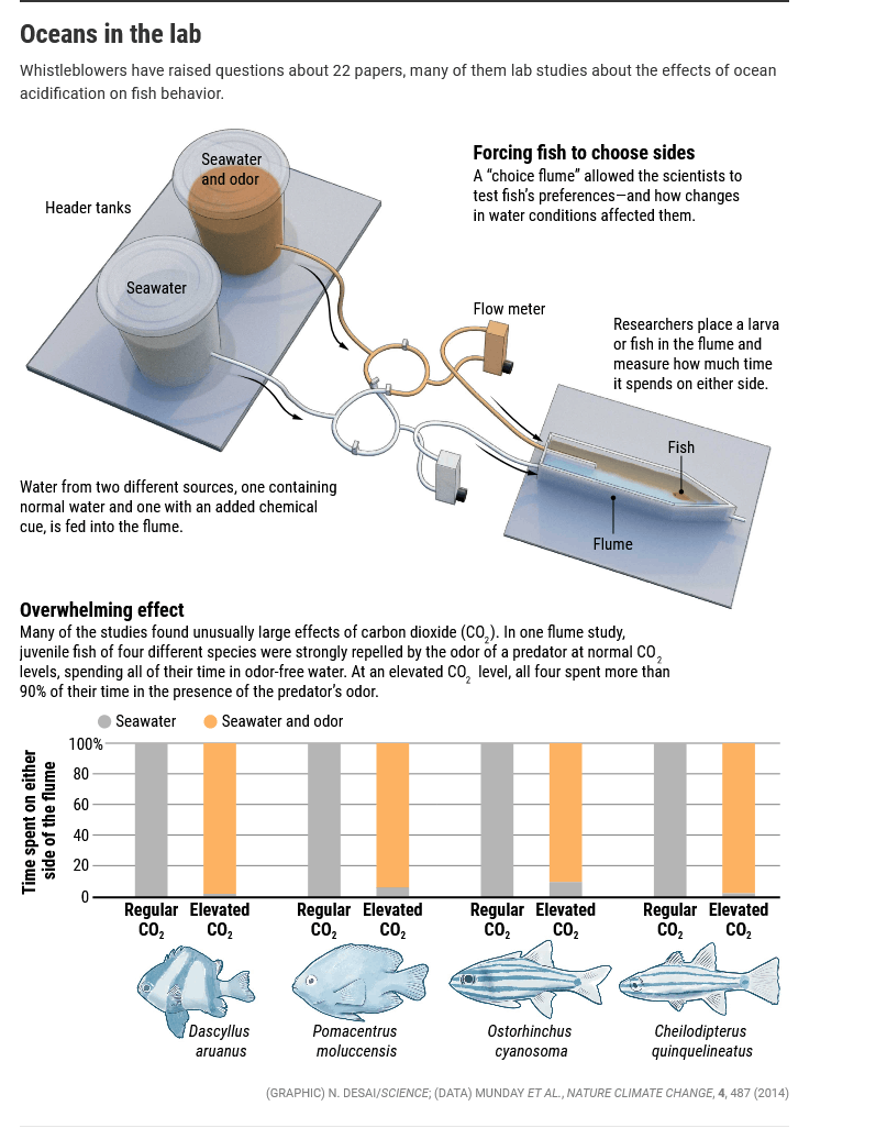
There’s a new paper by Morgan et al. out in Journal of Forestry in response to the Fleischman et al. paper we discussed here and here. Since I was one of the peer reviewers for this response paper, I’d like to give some of my meta-thoughts about how all this worked out- related to the biz of scientific paper publishing in general. I respect all the scientists here- we are all victims of the current system. There are some of the same solutions as in the fish disagreement I posted last Friday, even though there is no misconduct in this case.

  • First, this would never have been published had some researchers not felt strongly enough about, had the time, and had access to the original data (thank you to the original authors!) to write another paper. How often does this happen? We have no clue. I’m thinking quite seldom.
  • Second, much of this second paper IMHO was unnecessary and could have been resolved by the first set of reviewers simply saying “stick to the analyses you did, and don’t assert anything that isn’t a direct result of what you found.” Say, in this case, with statements about the FS budget.
  • Third, an open pre-review process (even at the proposal stage) would have helped improve the first paper, and answered the questions raised in this response paper, making the original paper better, and saving us all lots of time. For example, data cleaning procedures might have been discussed, and based on that conversation, clearly documented. In any scientific field, there are only a few people who “get” the specifics of the data, how it was obtained, the lab or modelling protocols, statistics and so on. Certainly editors try to get those people for reviews, but they would be the first to say that’s not easy to do; and many heads are better than three.
  • Fourth, either the Forest Service should do some sort of quality control on the PALS database, or people shouldn’t use it in research without a great many caveats. (It’s true I was involved in the development of PALS, so I do have a bias toward having it up-to-date and available to the public for our own queries.)

What most interested me about Morgan et al.  were their observations about data in PALS and areas for improvement of PALS, as well as the need to make it easier to locate information on objections and litigation. Here’s just a brief example.

Our examination of the PALS-MYTR revealed very different elapsed days to completion for the three NEPA analysis types. Therefore, the type of NEPA analysis the agency uses for a proposed land management action should be a major determinant of the time it takes to complete that NEPA analysis. The agency was seeking, with the proposed rule changes, to increase the number of CEs it can use and to broaden some of the CE authorities. When a proposed action is suitable for a CE, its NEPA analysis is far more likely to take less time and far less likely to be litigated based on the litigation rates discussed below.

The PALS-MYTR contains 1,269 ongoing analyses, which Fleischman did not analyze. Of the ongoing analyses, 320 are identified as “complete”, 655 “in progress”, and 294 “on hold”. Many (505) of the ongoing and in progress analyses were initiated in FY 2016–2019, but there are over 400 ongoing analyses from FY 2005–2015. Presumably the on hold analyses are paused, but there were over 100 documents on hold as of April 2019 that were initiated between FY 2005 and 2013. This is a long time for a NEPA analysis to be “on hold.” This is another indication of a dataset that needs more complete documentation and checking and cleaning before it is used for policy analysis. Further, the number of elapsed days from initiation until April 1, 2019, for all ongoing analyses ranges from 101 to 5,203 days, with an average of 1,180 elapsed days (more than three years). There are more than 880 NEPA analyses ongoing and not marked complete that will have elapsed days greater than the five-month average the original authors portrayed as proof that NEPA is “fast.” By analysis type, 824 (65 %) of the ongoing analyses are CEs, followed by 331 EAs, and 114 EISs. The presence of 249 ongoing and in progress CEs and 187 ongoing and in progress EAs initiated from FY 2014–2018 does not indicate that NEPA is “fast.” These data may suggest that cleaning of the PALS-MYTR dataset should be completed before drawing conclusions about the timeliness or efficiency of NEPA.

I think it is useful to (1) have a relatively accurate database (2) have it available to the public (3) look at the database for information about managing and understanding how the FS does NEPA. Having said that, even the old GAO reports said that R-1 had more than its share of litigation. So in simple language, as I said in previous comments, you can’t just take perceived regional problems nationally and average them into not being important. I mean you can, but that’s a value, not necessarily “what the science says.”

If you want to read the whole paper (it’s a must-read for NEPA aficionados), you can ask for a e-reprint from the main author.

BLM: Back to the (DC) Future?

Excerpt from a Greenwire article today:

The Bureau of Land Management is asking its employees for input into how to potentially revamp its headquarters to improve the bureau’s “function” after a massive Trump-era reorganization that included moving the leadership office to Colorado.

BLM, in an internal survey sent yesterday to all employees, asks staffers to gauge, on a scale of 1 to 10, the “Impact of BLM HQ Relocations” to Grand Junction, Colo., and other state offices in the West, on “employee morale” and “the function of the BLM overall.”

It also asks staffers point-blank: “In light of the recent relocation and current distribution of HQ positions in Grand Junction, Washington D.C. and other locations in the West, how should the BLM move forward?” Among the four answers employees can choose from: “Restore all positions to a D.C. location” and “Leave all positions as they are now.”

The survey also seeks employee input on how best to move the headquarters back to Washington, if the Biden administration ultimately decides to do so.

Toward a Fuel Treatment Zone of Agreement: Looking for Your Ideas

I’m working on a project for a conference in July.  My goal is to understand the views of environmental groups who are successful at influencing policy, either via political clout or via litigation, and to see whether there is a zone of agreement that could be imagined.  The goal being to increase the pace and scale of “restoration” (including fuel treatments) which is supported by all recent Administration, and to have such groups support the efforts at the least, or to help, at best.

I’m interested in getting feedback on my proposal and will touch base with The Smokey Wire as the project goes forward. Questions at this stage are below.

Here’s part of the writeup I did for a proposal.

“Some groups seem to support prescribed fire, but not mechanical treatment of fuels. While developing markets for woody material seems key to funding this work through time at the scale required, some organizations do not support these efforts. In some cases, they may think that those markets would ultimately lead to environmental degradation (pers. comm.). Many national groups are also active in efforts such as Wilderness legislation, and these designations would have impacts on suppression actions, as well as fuel treatments and, in some cases, the use of prescribed fire.

Where timber industry is active, we seem to have an endless conflict that is reminiscent of the old Timber Wars. Litigation holds up projects. Republicans want to streamline. Democrats argues that the methods used are bad, and that the R’s are in the pockets of the timber industry and want to destroy federal lands and so on.   Some scientists chime in with “logging won’t stop fires” and we’re off to the “talking past each other” races.

Meanwhile, other states without a history of Timber Wars simply want to develop some uses for material removed in mitigation efforts so that they can offset some costs, and not release carbon and particulates from burning piles. They may feel their views and needs are not seen at the national level because at that scale, the partisan framing of the issue has sucked all the oxygen (so to speak) out of the policy room. And the fact that Coloradans, New Mexicans, and Californians would like these markets for the material can’t ignite, or fan the flames of partisan factionalism.

To move into the future as we manage fire in a changing climate, we need to identify where we agree, and find national policies that suit both the Timber Wars and the market-free parts of the West.

For the purposes of this paper, I will focus two different kinds of groups. First are the litigators, and second, the national influencers who help set Administration policy and lobby Congress, which tend to be large national environmental groups. I will select five groups in each category.

For example, in the group of litigators would be Wild Earth Guardians, the Center for Biological Diversity, NRDC and others.

In the group of influencers would be the Sierra Club, the Wilderness Society, Defenders of Wildlife and others.

First, I will conduct a literature review on previous studies of these groups, and see if there has been any work done on their views on fire management. A preliminary review for this proposal has so far yielded nothing relevant.

Second, I will review the organizations’ websites for information on their views. For litigators, I will also use their comments on proposed projects to help understand their views.

Third, based on the website (and project comment) information, I will develop a series of questions and conduct interviews with key people in each organization. These interviews will include questions like “what are your concerns about current and future fire management?“ “do your concerns differ for private and federal lands?” “what does your organization currently contribute to discussions and implementation  of fire management policies?” and “what would it take for your organization to support interventions including mechanical fuel treatments, prescribed fire, and developing markets for small-diameter material?”. Other interview questions will be based on information found in the website review.

Fourth, based on these interviews, I’ll suggest some innovative policy ideas to be outlined in the paper.

So what groups do you think I should select and why? Have you run across any documentation of groups’ opinions? Have you seen any studies that examined views of environmental groups on this topic? Any other thoughts?

Practice of Science Friday: The Structure of Scientific Disagreement- Fish Behavior and Ocean Acidification

There’s a fascinating article in Science that delves into a scientific controversy around fish behavior and ocean acidification.  Martin Enserink is a journalist with Science who  wrote the article and sent me a link, so hopefully you can access it. It raises some questions about the science biz, how it works, and how it might work better.

The fight, between two groups united by their passion for fish, isn’t just about data and the future of the oceans. It highlights issues in the sociology, psychology, and politics of science, including pressure on researchers to publish in top-tier journals, the journals’ thirst for eye-catching and alarming findings, and the risks involved in whistleblowing.


Should extraordinary claims get closer scrutiny?

The paper has proved so polarizing in the field, “It’s like Republicans and Democrats,” says co-author Dominique Roche of Carleton University in Ottawa, Canada. Some scientists hailed it as a stellar example of research replication that cast doubt on extraordinary claims that should have received closer scrutiny from the start.

and

Not long after that paper was published, Science received a “technical comment” from JCU reef ecologist Andrew Baird, who noted several problems, including the fact that the water flow quoted for Dixson’s flume was much faster than any coral larvae have been reported to swim, meaning larvae would be washed out of the back of the flume. Science’s review process deemed the comment “as low priority for publication,” says Deputy Editor for Research Sacha Vignieri. (Science’s news and editorial departments operate independently of each other.) Baird published it as a preprint instead, but it drew little attention.

Maybe there should be a screen for “extraordinary claims” and/or “high degree political and policy implications,” that would invoke an open peer review process? Would this story have been different if that had been the case? I think much of the interpersonal drama might have been avoided, and of course, better research accomplished.

When Scholarly Discussion is Not Enough: Give Up or Blow Whistle or ???

The group learned some painful lessons. After a preliminary inquiry, a UU panel dismissed the request for an investigation in a terse report and berated the team for failing to discuss its concerns with Lönnstedt and Eklöv in a “normal scholarly discussion.” Lönnstedt said the group was simply jealous. The accusers spent many months gathering additional documentation, at the expense of their own research. In April 2017, Sweden’s Central Ethical Review Board concluded there had indeed been “scientific dishonesty” in the research, and Science retracted the paper; 8 months later, a full UU investigation concluded the data had been fabricated. (Eklöv blamed Lönnstedt; Lönnstedt maintained her innocence.)

The brazenness of the apparent deception shocked Jutfelt. “It really triggered my skepticism about science massively,” he says. “Before that paper, I could not understand how anyone could fabricate data. It was inconceivable to me.” Now, he began to wonder how many other papers might be a total fantasy. The experience also taught the group that, if they were ever to blow the whistle again, they would have to bring a stronger case right from the start, Clark says.

On the other side of the globe, the group’s accusations had Munday’s attention. “It seems that Clark and Jutfelt are trying to make a career out of criticizing other people’s work. I can only assume they don’t have enough good ideas of their own to fill in their time,” he wrote to Lönnstedt in a June 2016 email that she used in her defense to the ethics board. “Recently, I found out they have been ‘secretly’ doing work on the behavioural effects of high CO2 on coral reef fishes, presumably because they want to be critical of some aspects of our work.”

Others defended Munday and Dixson more diplomatically. Four “grandfathers in the field,” as Bruno calls them, criticized the replication in a paper in Biogeosciences. One author, Hans-Otto Pörtner of the Alfred Wegener Institute in Bremerhaven, Germany, says his own work had been on the receiving end of criticism from the “youngish group” in the past. “Building a career on judging what other people did is not right,” says Pörtner, who co-chairs one of IPCC’s three working groups. “If such a controversy gets outside of the community, it’s harmful because the whole community loses credibility.”

So.. according to Pörtner, criticism should stay within the community because otherwise the community would lose credibility. So people shouldn’t criticize each others’ work in public? Only via blind peer review, or publishing papers that disagree (given that the journal would publish them, because “not finding something” isn’t all that exciting). Leaving the rest of us to ponder “why did they come to different conclusions?”. I would actually trust the community more if their disagreements were in the open. I wonder whether that might be a role for the relevant scientific society.

Forest Service halts huge clearcutting and roadbuilding plan next to Yellowstone National Park

Grizzly bear sow and young cubs, Yellowstone National Park. Photo by Sam Parks.

Press release from WildEarth Guardians and allies is pasted below, and right here

WEST YELLOWSTONE, MONTANA— Following a challenge by multiple conservation groups, the U.S. Forest Service announced Thursday that it was halting a plan to clearcut more than 4,600 acres of native forests, log across an additional 9,000 acres and bulldoze up to 56 miles of road on lands just outside Yellowstone National Park in the Custer Gallatin National Forest.

In April, the Center for Biological Diversity, WildEarth Guardians, Alliance for the Wild Rockies and Native Ecosystems Council challenged the South Plateau project, saying it would destroy habitat for grizzly bears, lynx, pine martens and wolverines. The logging project would have destroyed the scenery and solitude for hikers using the Continental Divide National Scenic Trail, which crosses the proposed timber-sale area.

“This was another one of the Forest Service’s ‘leap first, look later’ projects where the agency asks for a blank check to figure out later where they’ll do all the clearcutting and bulldozing,” said Adam Rissien, a rewilding advocate at WildEarth Guardians. “Logging forests under the guise of reducing wildfires is not protecting homes or improving wildlife habitat, it’s just a timber sale. If the Forest Service tries to revive this scheme to clearcut native forests and bulldoze new roads in critical wildlife habitat just outside of Yellowstone, we’ll continue standing against it.”

In response to the group’s challenge, the Forest Service said it was withdrawing the South Plateau project until after it issues a new management plan for the Custer-Gallatin National Forest this summer. Then it plans to prepare a new environmental analysis of the project with “additional public involvement” to ensure the project complies with the new forest plan.

“This is a good day for the greater Yellowstone ecosystem and for the grizzlies, lynx and other wildlife that call it home,” said Ted Zukoski, a senior attorney at the Center for Biological Diversity. “The Forest Service may revive this destructive project in a few months, but for now this beautiful landscape is safe from chainsaws and bulldozers.”

The project violated the National Environmental Policy Act by failing to disclose precisely where and when it would bulldoze roads and clearcut the forest, which made it impossible for the public to understand the project’s impacts, the groups said in their April objection. The project allowed removal of trees more than a century old, which provide wildlife habitat and store significant amounts of carbon dioxide, an essential component of addressing the climate emergency.

“The South Plateau project was in violation of the forest plan protections for old growth,” said Sara Johnson, director of Native Ecosystems Council and a former wildlife biologist for the Custer Gallatin National Forest. “The new forest plan has much weaker old-growth protections standards. That is likely why they pulled the decision — so they can resign it after the new forest plan goes into effect.”

“The Forest Service needs to drop the South Plateau project and quit clearcutting old-growth forests,” said Mike Garrity, executive director of the Alliance for the Wild Rockies. “Especially clearcutting and bulldozing new logging roads in grizzly habitat on the border of Yellowstone National Park.”

Changing the Game: Using Potential Wildfire Operational Delineation (PODs) for a Better Future with Fire


FACNET (Fire Adapted Communities Information Network) is one of my favorite information sources.  This article was originally posted on the Fire Adapted Communities Learning Network Blog and is reproduced here with their permission.

The whole thing is worth a read and I’ve included some excerpts that give you a taste for it. It probably won’t surprise you that I like the combination of local knowledge and spatial analytics. Check out the video about the Arapaho Roosevelt NF and the Cameron Peak fire.  The maps of that fire reminded me that we can talk past each other when people write “fuel treatment in the “backcountry” can’t help protect communities” and in some parts of the country with current megafires, we actually don’t have a “backcountry.”
************************************************************************************************************************************************************

Editor’s Note: Tyler A. Beeton and Katarina Warnick are Research Associates with the Colorado Forest Restoration Institute at Colorado State University. They recently took part in a well-attended February, 2021 virtual workshop hosted by the Rocky Mountain Research Station’s (RMRS) Wildfire Risk Management Science team (WRMS). The workshop focused on Potential Operational Delineations also called PODs. The POD framework is an emerging collaborative spatial fire planning and decision support tool. Here Tyler and Katarina share their perspective on three key themes that emerged from the February workshop. They focus on how PODs can change the game for fire operations, strategic multi-year restoration investment and planning, and co-managing wildfire risk.

It was clear from the get-go that we weren’t the only ones excited for the inaugural Potential Operational Delineations (PODs) Collaborative Fire Planning Workshop, hosted by the Rocky Mountain Research Station’s (RMRS) Wildfire Risk Management Science team (WRMS) held virtually in February 2021. Well over 500 people registered in just 3 weeks after registration went live, which maxed out the Zoom room capacity and forced the planning committee to close registration. This event and topic was something folks were ready to engage on. And there is reason why – the PODs process is an exciting and emerging framework that leverages local expertise with sophisticated modeling tools to identify features on the landscape – the streams, roads, ridges and fire scars – that have a high likelihood of containing a fire (see example below). Since taking off, the PODs framework has been developed and deployed in different contexts across the United States (over 40 national forests and counting). And while PODs were initially envisioned to support incident management, managers and communities have expanded the application of this tool in a number of ways. Several key themes related to the potential benefits of PODs emerged from the workshop, here are three.

PODs network on the Pike San Isabel National Forests. Fire managers deliberate and hand-draw effective control lines based on their local knowledge and spatial analytical tools. The control lines are then digitized to develop the PODs network seen here.

…..

Shifting strategy from random acts of restoration to a targeted approach

Several individuals emphasized that the current model of ‘stands and compartments’ vegetation management where ‘random acts of restoration’ occur opportunistically on the landscape have been largely unsuccessful at managing wildfire at scale. Big, bad fires are still happening and worsening, and the social and ecological impacts are significant. Panelists and participants noted that PODs provide a framework to shift our strategy to long-term, landscape-scale treatment prioritization. The scale of actions needed to restore fire-adapted ecosystems is immense, and it is impractical to treat the entire landscape. Using the adage ‘the only way to eat an elephant is one bite at time,’ one panelist suggested the need to strategically restore landscapes one POD at a time. Doing so could contribute to meaningful outcomes at meaningful scales, in this case changing wildfire behavior across the “fireshed”. A fireshed is conceptually similar to a watershed, though is defined as areas that encompass similar wildfire risk and where the identification and prioritization of treatments can modify wildfire behavior (Bahro et al. 2007).

The Arapaho Roosevelt National Forests leadership tested this new model of thinking. Forest managers worked with partners to construct a line of PODs running north to south slated for thinning treatments and prescribed fire, the goals of which were to inhibit fire spread and protect communities and other assets to the east. This line of defense was tested during the 2020 Cameron Peak Fire, the largest wildfire in Colorado state history. Although the fire occurred before the strategy was fully implemented, fire behavior was significantly modified in most cases where it interacted with treated PODs and previous fire scars. Check out the video below depicting the fire spread, dark red polygons depict previous fire scars. Blue polygons denote PODs that were treated (thinning, burned) prior to the fire.

This shows that if the management objective is to change wildfire behavior and risk across large landscapes, there is a need for a multi-year restoration strategy. PODs provide a useful way to carve up the landscape making it more manageable for restoration and more relevant for fire operations. In addition, PODs can provide more meaningful outcomes and a more useful and visual tool in communicating the “what” and “why” of management actions across specialists, organizations and communities. Lastly, the strategy of collaborative planning allows for a shift in focus from standard performance-measures that emphasize outputs, such as timber volume, to outcomes that promote resilient landscapes and communities.

The Rest of the Story: the LAVA Project, the Mullen Fire, and Ongoing Implementation

From the LAVA Story Map, you can click on this image to get better resolution

We’ve talked about condition-based NEPA before in several posts. At the time I worked on a CBN project (2010-ish, Obama Administration), it was considered a way to deal with the need for management at the landscape scale. You’ll remember that “increasing the pace and scale” “landscape scale” and some version of “all lands, all hands” has been the view of several Administrations, and I don’t think is all that controversial. The idea goes something like this.. with climate change and past fire suppression (Ds) or past fire suppression and lack of timber management (Rs), there is a need to reintroduce prescribed fire and to protect watersheds, communities and species from uncontrolled wildfires (exacerbated by climate change.)

If I recall correctly, condition-based NEPA is in the current Forest Service NEPA regulations. But naturally, there are disagreements about specific NEPA approaches and specific projects.

We discussed the LAVA project on the Medicine Bow National Forest as an example of condition-based NEPA. Their argument, as with the Black Hills bug project, was that the changes in conditions due to bugs required flexibility. I wrote two posts on the WaPo story on the project (usually the WaPo is not too interested in Wyoming) here and here. It attracted much attention by some environmental groups.

I also delved through the documents to find their approach to site-specific public involvement, since some had expressed concerns about how/whether that would happen.

Last summer, there were major fires in that country, so what happened with the project? Fortunately, they have a handy webpage that summarizes the current status.


February 1, 2021 – During the fall of 2020 the Mullen Fire impacted the Medicine Bow National Forest, burning portions of six of the 14 accounting units that make up the LaVA project area. LaVA implementation is on hold in the six affected accounting units while Forest staff develop a supplemental information report assessing post-fire conditions in these areas. Additional information about the supplemental information report will be shared as it becomes available. LaVA implementation may proceed in accounting units that were not affected by the Mullen Fire in the Sierra Madre Mountain Range and the Northern Snowy Mountain Range (click here for details). Additional LaVA checklists for treatments in the unaffected accounting units will be released over the next few months. The LaVA StoryMap is being updated to reflect changes in the implementation schedule due to the Mullen Fire. Launch of the updated StoryMap is planned for early spring of 2021.

  • The LaVA StoryMap is an interactive GIS map where users can:

    • Learn more about the LaVA decision.

    • Utilize interactive maps of the Sierra Madre and Snowy Ranges in combination with LaVA project analysis data.

    • View past/current/future treatment locations and information.

    • Provide feedback on future treatments and focus areas.

    • Learn about cooperating agencies.

      I thought the story map was pretty cool and I posted an image from it above. I particularly like how they’ve made it easy for people without GIS skills to look at the overlays.

      So far, there has been no litigation and implementation of the project is ongoing. I wonder why, or what changed such that organizations which were against the project have apparently chosen not to litigate.

Wildfire and Roadside Hazard Trees in Oregon- Info From Region 6

Previously Steve posted this story from OPB that mostly focused on concerns about ODOT’s management of hazard tree removal. There was a link to a letter from a variety of groups which talked about the Forest Service.

There are a number of stories at OPB about ODOT’s efforts and management of hazard tree removal, including hearings with the state legislature.

There was one place in the article in which people agreed:

Law, Till, Ford and Allen all agreed it can take years for burned trees to become hazardous, but the state doesn’t plan to wait that long to see which trees need to be removed.

Andersen said arborists are monitoring trees for a few months to see if they become less hazardous over time but the state is sensitive to the risks involved in leaving potentially hazardous trees standing.

“We wouldn’t monitor for years with safety being the top concern if that tree dies,” he said. “I don’t think anybody wants the unfortunate job of going and telling the family that someone died on the roadway because we were monitoring that tree that inevitably fell during an ice storm.”

But leaving ODOT and going back to “what is the Forest Service doing?”, here’s the Region 6 reply to our questions about roadside salvage.

Last summer’s wildfires burned more than 1.2 million acres across Oregon on federal, state, local, and private lands. In September we stood up a regional Operation Care and Recovery team to coordinate efforts to help our employees, the public and communities impacted, and the lands we manage recover. We have been focused on emergency safety and stabilization actions, including working with ODOT and FEMA to remove dead or fire-weakened hazard trees along roadways and near recreation areas to address safety risks to the public and our employees.

We have been completing this work under emergency response provisions and categorical exclusions.

 Below are the links for the danger tree and hazard tree guides. We’re using these along with environmental protection plans and the ODOT protection agreement to guide overall criteria.


You can find any Forest Service salvage (or other) projects by going to the forest’s webpage, going to land management on the sidebar and then projects.

Climate lawsuit challenges fracking threatening national forest in Colorado

The North Fork Valley, Colorado. Photo by Ecoflight.

Here’s the coalition press release:

WASHINGTON—Conservation groups filed a lawsuit today challenging the Bureau of Land Management and U.S. Forest Service’s 2020 approval of a plan that allows fracking across 35,000 acres of Colorado’s Western Slope. The North Fork Mancos Master Development Plan allows 35 new fracking wells in the North Fork Valley and Thompson Divide areas of the Grand Mesa, Uncompahgre and Gunnison National Forest.

Today’s lawsuit says federal agencies violated the National Environmental Policy Act and other laws by failing to fully assess the potential for water pollution and harm to the climate, and by refusing to analyze alternatives that would minimize or eliminate harm to the environment. The plan would result in about 52 million tons of greenhouse gas pollution, equivalent to the annual pollution from a dozen coal-fired power plants.

“This case is about confronting the Trump administration’s complete disregard of law, science, and public lands,” said Jeremy Nichols, Climate and Energy program director for WildEarth Guardians. “We can’t frack our way to a safe climate and we certainly can’t afford to keep letting the oil and gas industry run roughshod over Colorado’s irreplaceable and vital public lands.”

“The Trump administration charted a course to destroy public lands and our shared climate,” said Peter Hart, staff attorney at Wilderness Workshop. “This master development plan is a 30-year commitment to the disastrous ‘energy dominance’ agenda which ignored significant impacts on the communities and spectacular values of the North Fork. We are determined to hold our federal government accountable to a more sustainable future for Colorado’s public lands, wildlife, people, and climate.”

“Fossil fuel development and sustainable public lands don’t mix, especially in the roadless headwaters of the Upper North Fork Valley,” said Brett Henderson, executive director of Gunnison County-based High Country Conservation Advocates. “This project is incompatible with necessary climate change action, healthy wildlife habitat, and watershed health, and is at odds with the future of our communities.”

“We are in a megadrought in the North Fork Valley and the Western Slope. The water used to frack in the watershed risks precious water resources and only exacerbates the climate and the water crisis,” said Natasha Léger, executive director of Citizens for a Healthy Community. “This 35-well project is the beginning of much larger plans to extract a resource that should be left in the ground and for which the market is drying up.”

“This dangerous plan promises more runaway climate pollution in one of the fastest-warming regions in the United States,” said Taylor McKinnon of the Center for Biological Diversity. “We’re suing to force federal agencies to stop ignoring the climate emergency. Like the planet, the Colorado River Basin can’t survive a future of ever-expanding fossil fuel development.”

“It is past time for the federal government to meaningfully consider climate change in its oil and gas permitting decisions,” said Melissa Hornbein, attorney at the Western Environmental Law Center. “Gunnison and Delta Counties have already exceeded 1.5°C of warming; the project failed to meaningfully analyze impacts to climate, roadless areas, and the agriculture and eco-tourism centered economies of the North Fork Valley. More drilling is projected to harm Delta County’s tax revenue, not help it. These communities need land management that serves the public interest.”

Colorado’s Western Slope is already suffering from severe warming. The Washington Post recently featured the area as the largest “climate hot spot” in the lower 48 states, where temperatures have already risen more than 2 degrees Celsius, reducing snowpack and drying Colorado River flows that support endangered fish, agriculture and 40 million downstream water users.

In January 574 conservation, Native American, religious and business groups sent the then president-elect a proposed executive order to ban new fossil fuel leasing and permitting on federal public lands and waters. In February the Biden administration issued an executive order pausing oil and gas leasing onshore and offshore pending a climate review of federal fossil fuel programs. In June the Interior Department will issue an interim report describing findings from a March online forum and public comments.

Background: Fossil fuel production on public lands causes about a quarter of U.S. greenhouse gas pollution. Peer-reviewed science estimates that a nationwide fossil fuel leasing ban on federal lands and oceans would reduce carbon emissions by 280 million tons per year, ranking it among the most ambitious federal climate-policy proposals.

Oil, gas and coal extraction uses mines, well pads, gas lines, roads and other infrastructure that destroy habitat for wildlife, including threatened and endangered species. Oil spills and other harms from offshore drilling have inflicted immense damage to ocean wildlife and coastal communities. Fracking and mining also pollute watersheds and waterways that provide drinking water to millions of people.

Federal fossil fuels that have not been leased to industry contain up to 450 billion tons of potential climate pollution; those already leased to industry contain up to 43 billion tons. Pollution from the world’s already producing oil and gas fields, if fully developed, would push global warming well past 1.5 degrees Celsius.

The Slovenly Wilderness: Anatomy of a Zoom Town by Stacy Young

Gmap of St. George, Utah.

There has been a great deal of migration to the Interior West as part of the response to Covid. An example from Wyoming is here. People are moving out of the Bay Area in California, either to other parts of California, or away from California entirely. There’s an interesting interview here on WBUR Boston on this. People want to move away due to commuting and expense, but also I think possibly they don’t want to live in densely built cities next to public transit.. and don’t have to, if jobs are remote.

I think of them as maybe generational or some other kind of dimension of the challenge, because we know how to build houses. We have the technology elevators for more dense urban areas. We know how to do lots of things, including transit. But for some reason, the political structure isn’t allowing us to do any of those things that basic planners, basic economists have figured out.

Maybe it’s time to ask people if they want to live in those kinds of places, and press “reset” on the current planning paradigm. Maybe rents and home prices would naturally decline if only the people who had to physically be at work were in cities.

The relevance of all this to the Forest Service is clearly mega-increases in recreation, and the need for management of recreation impacts. It also affects the ability of employees to purchase homes in some amenity communities (of course, this has long been the case for employees in places like Jackson, Wyoming).

Having said all that, one of the most thoughtful pieces I’ve seen on this is by Stacy Young in the Canyon Country Zephyr in an article focusing on St. George, Utah. The article starts with a reference to pre-Covid and then looks at Covid-induced enhancement of those trends. Check the whole piece out, it’s a topic that isn’t written from the “moved to” places’ perspective all that often.

A year ago, I wrote about the development of the Little Valley area of St. George in southwest Utah. What I tried to do in that piece was use words, pictures and numbers to provide a specific example of what happens when good intentions and visionary land use plans are overwhelmed, as they usually are, by the dual pressures of industrial tourism and amenity in-migration, on the one side, and recalcitrant NIMBYism, on the other.

That piece was meant to be a case study pushing out on my running argument that the relatively recent phenomenon of permanent tourism is turning the ordinary, historical understanding of cities-as-labor-markets on its head. And to show, in effect, that it is almost certainly technocratic wishcasting to think that Good Planning will save a place from the cataclysmic money that is rushing into parts of Utah’s canyon country.

That essay was written in the Before Times and so it may be worth checking in to see what, if anything, has changed in the St. George area in the intervening year. What follows may also count as a partial reply to a comment left by reader Chris Patterson to that earlier piece:

What do people do for work in St George? I’m curious what all the new migrants do to pay for those 400k+ homes.

And what is the water source for this clearly water-intensive form of development?

And at what  point will “amenity migration” stop because the amenities are ruined?

Thanks for an informative, and depressing, article. I wonder when this ideal of the over-large home on the plot of irrigated grass will finally just die out…

Many of us who have worked in Forest Service jobs have experienced this phenomenon directly and not just recently (remember Oregon’s efforts to encourage people not to move there? check out this Bill Moyers video from 1973 (yes, almost 50 years ago now).  I like Young’s point #3. In our own states we all have examples of, say, Florence CO is not Aspen, it’s not even Meeker.

The existence of an “amenity” in a place is a necessary but insufficient condition for amenity migration. The capacity for move-ins to decouple their economic well-being from the local labor market is also imperative.

  1. What constitutes an “amenity” is far more subjective than ordinarily presumed. The opportunity for capitalistic manufacture of amenities is nearly endless. But do not expect amenitization’s synthetic flexibility to be evenly or constructively employed. Count on this feature not to ameliorate social problems but to exacerbate them.

  1. “Amenity migration” is a nice, clean term that implies a more uniform phenomenon than exists in practice. There are certainly commonly observed features, but the differences matter and they are pronounced. One community may grow in more or less normalish ways. Another may not grow its permanent community at all and instead simply become an ever more exclusive enclave of dilettantes and consumers. Most places will fall outside either of these two extreme descriptions.
  1. It is the epitome of technocratic arrogance to suppose that amenity migratory patterns will readily yield to planning or analysis. Human civilization is more like an organism than a machine; it is complex rather than merely complicated.

Coda. Californians*, having ruined their own primary housing markets, are no longer content to export just a bit of their dysfunction onto one rarified second-home destination or another, but instead appear set to entirely wreck any number of housing markets across Texas and the interior West. Let’s dissect the process, using figures from San Mateo County in the Bay Area to help illustrate.

Step one: Create a massive housing gap. “Between 2010 and 2019, 102,500 new jobs were created in San Mateo County, while only 9,494 new housing units were built, a 11:1 ratio.”

Step two: Wait patiently as the extreme imbalance between housing demand and its supply causes home values to become an exercise in absurdity. Between the mid-90s and now, the median home price in San Mateo County skyrocketed from the mid-$300,000s to about $1,700,000, a roughly 5-fold increase.

Step three: Engage in a little harmless arbitrage. Use the internet tools invented in and around San Mateo to remain attached to the Silicon Valley labor market while detaching from its dysfunctional housing market.

Step four: After selecting your Zoom Town of choice, cash out your home equity and reinvest all or most of it in your lucky new hometown. It’s almost like an early-stage investment in an exciting new startup!

Bonus step five: Charm new acquaintances by expressing shocked delight at what a nice house $1 million gets you.

Bonus step six: Continue your old home voter ways in your new hometown by furiously and without a trace of irony lobbying your local elected officials to clamp down on housing production lest the place “turn into California.”

[* Here, the terms “California” and “Californians” stand for something broader than the named state and its residents. This is an attempt to describe a macro process and I’m simply using these specific labels because they represent the most visible and most clearly distilled example of the phenomena.]