I may have missed it, but was there already a post on the Custer-Gallatin plan? This news story from Explore Big Sky talks about it, and about how collaboration on the plan worked. And it only took six years, which is good for a complex plan.
“In the first stages of this, we had a bunch of people involved in these meetings, who really honestly never had any intent of collaborating on anything,” said Big Sky resident Steve Johnson. “There were significant factions on both extreme ends of, you know, it’s my way or no way.”
Johnson has been involved in the process since early conversations about a decade ago. At a certain point, he said, it became clear that a collaborative agreement wasn’t going to happen.
In the interest of providing cohesive feedback to CGNF, Johnson and other individuals from the surrounding area formed the Gallatin Forest Partnership in 2016 and submitted the final Gallatin Forest Partnership Agreement to the forest service in 2018. Johnson said that agreement became the basis for the plan the forest service ultimately produced.
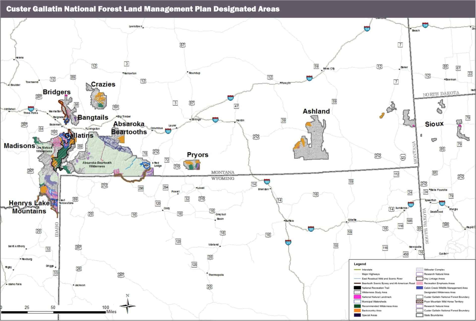
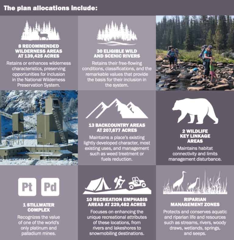
The agreement details a future for the Gallatin and Madison Ranges that protects wildlife, clean water, wilderness and recreation opportunities through recommended protections and wildlife management areas. Specifically, the document incorporates new land protections that will help guard clean water and ensure safe passage for wildlife while maintaining existing recreational opportunities and seeking to limit new development.
“[The partners] came to the table with a spirit of ‘let’s work something out’ and we did,” Johnson said in a Feb. 7 interview. “I’m tremendously proud to have been a part of that. And given what’s going on in the country these days, anything that actually comes to an agreement amongst disparate parties is sort of a miracle.”
Leuschen-Lonergan explained that the recommended wilderness and type of land allocations drew some of the most diverse perspectives and sparked the most disagreements. The balance of sustainability and preserving public access struck by the plan was informed by focusing on the common ground in the extensive public comment received by the forest.
“It was a pretty lengthy process, and we’re very thankful and fortunate to have people … across the Custer Gallatin, all seven districts, that really care about and are passionate about these public lands and want to be involved in the process,” she told EBS. “Because of that, we were able to build a more … inclusive and robust plan that as we move forward for the next 10 to 15 years, incorporates a lot of people’s thoughts and perspectives and is a better plan because of the involvement that we had.”
Despite being sacred to the Apsáalooke the federal government has twice proposed the Awaxaawapìa Pìa or Crazy Woman Mountains sometimes called the Crazies as a location for a national park but half the land and every alternate section was owned by the Northern Pacific Railroad or was otherwise privately held.
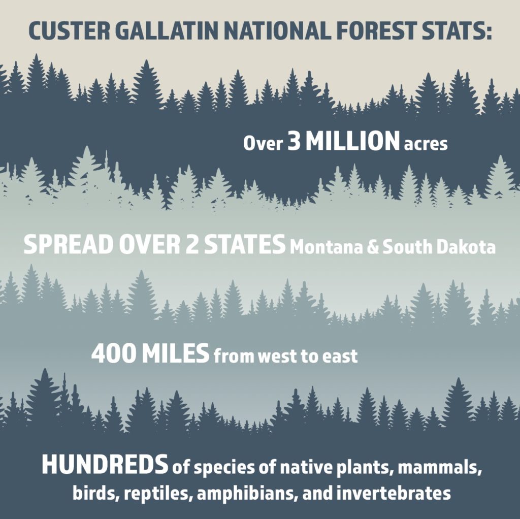
In 2014 two national forests based in Montana, one named for the Swiss guy who helped convince President Thomas Jefferson to use an executive order to buy land from a country that didn’t even own it and one named for a war criminal were merged into a single administrative unit.
Today, most of the public land is shared by the Custer Gallatin and Lewis and Clark National Forests but even tribal access has been blocked by the descendants of European settlers.
Now, Mary Erickson is the Forest Supervisor for the Custer Gallatin National Forest based in Bozeman and she just signed the record of decision (ROD) for the Custer Gallatin National Forest Land Management Plan. The Sioux Ranger District in northwestern South Dakota is part of her purview; it’s where radioactive waste in the Cave Hills area went for decades without remediation because the Board of Minerals and Environment is an arm of the South Dakota Republican Party.
Not only is it some of the most spectacular landscape in sight and geology it’s also home to one of the largest populations of merlin falcons in North America in a district that’s heavily grazed and logged, most of it by none other than Neiman Enterprises.
It’s time to move the US Forest Service into the Department of the Interior, dissolve the Black Hills National Forest and make it a national monument co-managed by the Park Service and the tribal nations signatory to the 1868 Fort Laramie Treaty. Mato Paha (Bear Butte), the associated national grasslands and the Sioux Ranger District of the Custer Gallatin National Forest should be included in the move.