Improving public access to public lands

We have discussed “corner crossings” and other barriers to public land access resulting from land ownership patterns.  Overlaying this is another barrier – availability of information about the extent of public access that does exist.  It turns out there is a lot more existing public access than meets the eye, and some technology and legislation is making more information about it available to public land users.

… the Theodore Roosevelt Conservation Partnership teamed up with onX to quantify the scope of the landlocked public lands problem and offer solutions that would open access to these acres. Since 2018, the team has found a staggering 16.43 million acres of inaccessible public land across 22 states. …  With $27 million from the Land and Water Conservation Fund dedicated to increasing public land access each year, there is an incredible opportunity to address the landlocked public lands problem through strategic land acquisitions and access easements.

We soon learned that the Bureau of Land Management and U.S. Forest Service held roughly 90,000 such access easements—where permanent access to public land has already been secured—but 50,000 were only recorded on paper, stored away in the dusty filing cabinets of local agency offices.  Neither the agencies, nor the public, have ever had a complete digital picture of where there is legal access to our public land. Seeing a clear need for a solution, TRCP experts began talking with lawmakers, which led to introduction of federal legislation called the Modernizing Access to Our Public Land Act.

The MAPLand Act requires federal land management agencies to digitize their paper easements, information about roads and trails and vehicle type on federal land, and the boundaries of areas with federal rules concerning weapon type and shooting. The ultimate goal is to make all of this information readily available to the public.  In April 2022, the MAPLand Act was signed into law.  This means that complete and consistent mapping data about road, trail, and shooting access will be digitally available to hunters and anglers wanting to use their public lands.

Of course funding this in a deficit-reducing environment may not happen as fast as we’d like.

The Forest Service role in fire adapting communities

https://planningforhazards.com/wildland-urban-interface-code-wui-code

It’s rare when I run across reporting about the Forest Service taking an official position on development of private land.  Yet the importance of doing so is increasing in a world where more frequent and dangerous wildfires on national forests are affecting human developments.  Here is one of those rare examples.

Grand Targhee Resort in Idaho has proposed adding cabins to its base area of private land, 120 acres surrounded by the Caribou-Targhee National Forest.  This has been controversial, in particular because of concerns about limited access and how the Resort would plan for and respond to wildfire.  The Forest Service has expressed concerns to the county commissioners about the ability to fight wildfires there.

Asked where Targhee fell in his list of wildfire priorities, Jay Pence, Teton Basin District Ranger for the Caribou-Targhee National Forest, said the resort was “towards the upper end.”  “It’s always been that way,” Pence told the Jackson Hole Daily. But, he added, “the new development just adds additional people and additional values at risk.”

To mitigate wildfire risk, Pence asked commissioners to require a few things of Targhee. It would be “helpful,” Pence said, to have “a clear and agreed-to emergency plan for the entire resort” as well as a “loop road” within the resort, and more information about “how the entire development is envisioned to be constructed.”  He also asked for fuels reduction work to be done while the cabins are built.  And Pence asked commissioners to “insist” on a 300-foot setback from the U.S. Forest Service’s property line, hoping to prevent the forest from having to clear vegetation on public land to protect the cabins from fire.

But Pence said any fuels reduction done on the forest will require separate permitting under the National Environmental Policy Act. It would likely require a separate analysis from the ongoing analysis of Targhee’s request to expand its boundaries.

This commercial development of an inholding is kind of an extreme case, but the kinds of things the Forest Service is asking for should be considered in any WUI development.  The National Cohesive Wildland Fire Management Strategy identifies “fire adapted communities as one of three goals, and “Protecting homes, communities, and other values at risk” as one of the four “broad challenges.  The Forest Service has a “Fire Adapted Communities Program,” which includes “tools of fire adaptation” like, “Wildland urban interface codes and ordinances can define best practices for construction and location of new development in a WUI community …”

I would like to know if there is also any agency guidance for Forest Service land managers for how to promote achieving these desired outcomes.  They need to be able to effectively participate in local planning for private land developments that will become “values at risk” for national forest fire management.  This ranger is doing the right thing, but is there any agency leadership that would encourage more of it?


Resort Towns: Affordable Housing for Workers, Living in Cars and Camping on Nearby Federal Land


This interesting article by Bruce Finley of the Denver Post may be pay walled so I will try to hit the highlights; it focused on Colorado mountain towns, but the problem is certainly wider.

Across mountainous western Colorado, cars as cocoons for sleep and sanity serve as last-resort shelters helping hundreds who provide services stay around. Yet “parking is at a premium,” said Margaret Bowes, director of the Colorado Association of Ski Towns, welcoming the creation of new designated overnight lots.

“It’s just a safe place to park where people aren’t going to be bothered by police,” Bowes said. “These are the people keeping our communities running. We need them here.”

Not that vehicle living is easy for workers who, after completing shifts cleaning, cooking and shop-keeping, can face disapproving glances and have to slip strategically into toilets and showers.

Local business manager Scott Link, 45, recalled: “the things that come with this — the depression, the paranoia” — after a three-year stint “trying to keep a really low profile” while living out of a white camper truck with his two pit bulls.

“I was losing my mind. I was close to killing myself,” said Link, who moved back to his native southern California for a change of venue after his grandmother died and then found housing with his girlfriend in Buena Vista, 24 miles north of Salida (pop. 5,752).

The Colorado Sports Recycler shop he manages has become a popular hub where he and colleagues inject humor into hard times by creating bumper stickers.

“One less Sprinter” stickers, poking fun at the high-end Mercedes camper vans roving around the West, quickly sold out.  “Now, it’s like even living out of your car is gentrified,” explained Brendan Gibbs, 37, sitting with Link in the shop one recent evening before heading back to his latest public land parking spot. He earns nearly $30 an hour building towering houses he reckoned he could never afford.

Next bumper sticker in the works: “Salida: where the locals live in motels and tourists stay in houses.”

The squeeze has intensified as the internet enables expanding commercial use of housing for short-term rentals and a COVID-19-era influx of well-to-do people fleeing dense-packed cities drives up prices.

**************

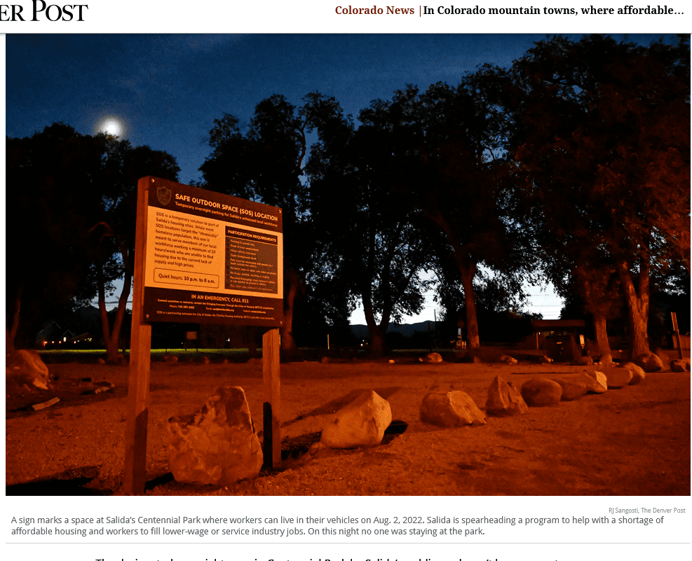
The designated overnight zone in Centennial Park by Salida’s public pool won’t be a magnet because only workers sponsored by employers can receive window-sticker permits, Nelson said. “This is designed for the workforce, not just whomever is rolling into town.” Similarly, the campers are available only for workers.

Mayor Dan Shore supported these innovations, navigating neighborhood criticism by emphasizing economic imbalances with houses costing more than ten times the annual median income of around $60,000. “These are workers who serve you and your families.”

But longtime resident and logger Kirby Perschbacher, 70, demands better, urging town leaders to focus on broader economic problems rather than settling for a temporary fix. Perschbacher sees newcomers flocking from cities and transforming Salida as the problem.

“They don’t want to work. They want somebody to serve them. They are creating a servant class,” Perschbacher said. “Our workers should be paid enough so that they don’t have to live out of their cars. It might be better not to put a band-aid on it. This is a pretend fix.”

*************

On Wednesday afternoon, a man who grew up in Salida sat in his brother’s parked pickup truck with the door open, a blue cruiser bicycle parked beside it, along banks of the Arkansas River. He was savoring shade given by a towering cottonwood tree near where a sign said “no overnight camping.”

Their parents bought a house in Salida for $25,000 in 1975. The family sold it, and the man said he and his brother would be hard-pressed to re-purchase it for under $700,000. He’s worked as a sheriff’s deputy and for a state government agency in the past and now, at age 52, had worked most recently installing carpet.

“It is still my town,” he said, asking that his name not be published for fear this would bring trouble from other residents. He knew about the new SOS parking lot option. “I can’t afford a permit,” he said.

Salida code enforcers pulled up just then in a white van marked “community services.” Two officers got out and Sean Lombard, Taser stun gun on his belt, approached.

“You can’t stay here overnight. Stay out of the city if you are camping,” Lombard said.

*******************

Kort also owns a campground. The fees for camping range from $22 a night to $56 a night at a KOA facility west of Salida. On BLM and U.S. Forest Service land, rangers increasingly enforce 14-day limits on parking and camping in one place, struggling to manage human impact on delicate natural terrain.

******************

There appear to be  many dispersed camping spots around Salida that are not necessarily “delicate” terrain.  Also, people could drive to different ones every night or every 13 days.  It would be interesting to hear from federal land managers with their concerns and solutions.

Where should fire suppression be a “fact of life?”

Sharon referred to “where fire suppression is a fact of life.”  I referred to the planning question of identifying where those areas are.  It seems to me that would be either where fires won’t ever occur (hard to imagine), or where they can’t be allowed to burn.  The reason in the latter case would depend on some kind of values at risk.  I continue to be amazed at how unwilling the Forest Service is to attack this problem from that direction – minimizing the values at risk in areas that are likely to burn.  In particular, their engagement (or lack thereof) with local community planning for developments and infrastructure.  And there are other reasons besides fire risk, in particular fragmentation of wildlife habitat that reduces connectivity.

Any way, here is an example from the Croatan National Forest.

The 2002 Croatan National Forest Land and Resource Management Plan stated that around 70 percent of the Croatan is home to short interval fire-adapted ecosystems—like pine trees and pocosins.

Low-intensity, prescribed fires allows nutrient cycling to occur. Without them, the entire structure and composition of species are subject to change.

“These are fire-maintained habitats, without prescribed burnings, it is like trying to save a salt marsh without the tide,” said Fussell.

Longleaf pine restoration is especially dependent on prescribed fires as the exposed soil helps the seeds to germinate and they control the population of competing pine variations.

Prescribed burning is harder to do the more fragmented an ecosystem is and the closer it gets to development. Because it is harder to burn in smaller areas, prescribed burnings have decreased in recent years, said Fussell.

The Forest Service has a legal imperative to NOT allow the structure and composition of species to change.  Where adjacent development has already occurred, fire suppression is probably going to be a “fact of life,” but that fact should be motivating the Forest Service to participate in local planning to encourage future development consistent with the fire regime on the adjacent national forest.  It’s difficult to understand why no one from the Forest Service was interviewed for this article, since they should be on the forefront of these kinds of discussions.  (They evidently did get involved in some highway planning in order to continue prescribed burning, which at least suggests they recognize the problem.)

This article cites some research that reiterates the findings of the Forest Service “Forest on the Edge” program (which I contributed to along the way).

By 2030, a study from 2009 by researchers at the University of Wisconsin and other industry professionals, projects that 16 million new housing units will be built around national forests across the United States. A projected 662,000 will be built in national forests.

“New houses will remove and fragment habitats, diminish water quality, foster the spread of invasive species and decrease biodiversity,” stated the study.

This is happening everywhere, and the Forest Service needs to be more assertive in trying to minimize the areas “where fire suppression is a fact of life.”

Private land conservation easements benefit national forest wildlife

In 2009, the owner of a golf course in Georgia donated a conservation easement to a non-profit land trust.  The easement included roughly 57 acres of primarily bottomland forests and wetlands along the Savannah River that would not be developed.  That land is directly across the river from the Sumter National Forest, 700 feet away.

To obtain a tax deduction for the conservation easement, it has to be “exclusively for conservation purposes” based on one or more of the criteria in the Internal Revenue Code.  They include:

(ii) the protection of a relatively natural habitat of fish, wildlife, or plants, or similar ecosystem,

(iii) the preservation of open space (including farmland and forest land) where such preservation is–

(I) for the scenic enjoyment of the general public, or

(II) pursuant to a clearly delineated Federal, State, or local governmental conservation policy,

and will yield a significant public benefit,

These issues were recently litigated by the IRS for this easement in the 11th Circuit Court of Appeals, which found the donation to be eligible as both habitat (ii) and scenic open space (iii)(I).  IRS Treasury Regulations elaborate on these requirements with regard to habitat by including “natural areas which are included in, or which contribute to, the ecological viability of a local, state, or national park, nature preserve, wildlife refuge, wilderness area, or other similar conservation area.”  However, the court accepted expert testimony from the IRS that the easement did not support the forest’s ecological viability.

There is no mention of testimony from the Forest Service. The 2012 Planning Rule stresses that, planning for ecological integrity must take into account “conditions in the broader landscape that may influence the sustainability of resources and ecosystems within the plan area” (36 CFR §219.8(a)(1)(iii)).  In addition, where a national forest plan area can not maintain a viable population of a species of conservation concern, “the responsible official shall coordinate to the extent practicable with other Federal, State, Tribal, and private land managers having management authority over lands relevant to that population” (36 CFR §219.9(b)(2)(ii))).

The also court determined, regarding open space (iii)(II), that, “There is no qualifying federal, state, or local government conservation policy that applies to this land…” In fact, the Forest Service Open Space Conservation Strategy includes this vision: “Private and public open spaces will complement each other across the landscape to provide ecosystem services, wildlife habitat, recreation opportunities, and sustainable products.”

In this case, private land adjacent to a national forest was conserved, but there is no evidence that the Forest Service was even paying attention.  The Forest Service needs to be more alert to these opportunities that would benefit national forest resources as well as contribute to greater national conservation needs.  Maybe if the Forest Service promoted its conservation policies better, they would facilitate more donated easements and protect more habitat for wildlife species that also use national forests.

Along somewhat the same lines, conservationists in Florida are striving to conserve the Ocala to Osceola Wildlife Conservation Corridor, which would connect the two national forests of those names across 50 miles of multiple other ownerships (including a military base).  Here is a presentation by the U. S. Natural Resources Conservation Service, which uses funding from the federal Farm Bill Resource Conservation Partnership Program to purchase conservation easements and create wildlife habitat on private lands within the corridor.  (This is the kind of “governmental conservation policy” that should also support federal tax deductions for donated conservation easements.)

The federally endangered red-cockaded woodpecker is an excellent example of a species that the Forest Service needs to coordinate management with others for, and here’s a bit of the success story about that in the O2O Corridor.

A red-cockaded woodpecker (RCW) captured at Camp Blanding in Clay County is evidence that a project led by North Florida Land Trust to preserve land within the Ocala to Osceola (O2O) wildlife corridor is working.  The bird captured at Camp Blanding was the first time this endangered species had moved between one of the national forests and the military installation since they began banding and recording the birds over 25 years ago.

“USDA Forest Service” is listed as a “partner” by NRCS, and the “National Forest Service” by the North Florida Land Trust.  The latter gives me a sense of how deeply the Forest Service has not been involved, and I sure can’t find anything about this effort on either national forest website or using a national search.  It’s too bad the Forest Service isn’t providing more leadership (and getting more of the credit) for conserving its important wildlife resources.

Grand Canyon development proposal resurfaces on the Kaibab

We’ve discussed the use of land exchanges that would facilitate the growth of urban areas by giving them more private land in logical growth areas using the example of Las Vegas.  At a different scale, the town of Tusayan appears to be an inholding in the Kaibab National Forest, which limits its growth opportunities.  They have been looking at a proposal to develop a nearby separate inholding (which the town owns a part of).   It would require a special use permit to for roads and utilities to cross national forest lands.  It has been controversial (attracting unwanted attention according to the town; the 2nd Twitter link works), and the town has just approved a revised proposal, which will be submitted to the Forest Service.  The Kaibab National Forest rejected the last proposal in 2016 as inconsistent with the requirements for a special use permit.  Here is a part of the rationale that relates to the forest plan:

CFR 251.54(e)(l)(ii) requires that the proposed use must be consistent, or can be made consistent, with the Kaibab Forest Plan. The Forest Plan envisions management at a landscape­ scale by taking an “all-lands approach,” and specifies strategies to achieve the desired conditions and objectives in the Plan, including working closely with partners and across administrative boundaries to meet common objectives. The development that would be enabled by authorization of the proposed use of NFS lands could substantially and adversely affect Tribal lands and the Grand Canyon National Park.

36 CFR 251.54(e)(l)(v) provides that the proposed use must not unreasonably interfere with the use of adjacent non-National Forest System lands. The FS received written comments from the National Park Service (NPS) through the Principal Deputy Assistant Secretary of the Interior for Fish Wildlife and Parks which pointed out that potential impacts to the Outstanding Universal Value of the Grand Canyon National Park (GCNP), either from the roads that would be authorized by easement or the reasonably foreseeable development on the two private properties that would be enabled by the roads and other facilities, are of concern. The GCNP also raised concerns in a meeting regarding impacts on infrastructure that they share with the Town of Tusayan. The NPS was concerned that any activity that would result in significant increases in visitation or occupation near the Park would affect the Park’s capacity to absorb the additional use.

The first rationale is an interesting “all-lands” interpretation of its forest plan to encompass the objectives of the National Park Service and tribal lands.  The second rationale stands on its own, but it also explains what those interests are.  It’s not obvious that the recent modifications in the proposal are going to address these concerns, so I expect we’ll be seeing more about this.  (Here is the CBD take on the original proposal.)

150,000 acre “project” on the Bitterroot

Well, not exactly, maybe.  This could be a good example of how to get the public involved early enough in the process for timber harvest decisions that the locations have not been determined yet.  But consider that the decision-maker is the same one who applied “condition-based” NEPA analysis to the Prince of Wales area of the Tongass, which has ended up in court.

Bitterroot National Forest Supervisor Matt Anderson has added a new “pre-pre-scoping” stage to the process, not part of the traditional process in which a set of options is presented to the public for review and analysis.

The new approach is meant to get the public involved prior to coming up with any specific actions being planned for any specific location.

That much I like the sound of.

“There is confusion,” said Anderson. “It’s hard for the public to get involved. We are asking ‘What do you want to see? What’s your vision?’” He said the agency was “starting at the foundational level, not any particular location.” He said it was important to get to those particulars but the way there was to first describe the “desired future condition that we want and then look at the various ways we can achieve it.”

Asked about the fact that the current Forest Plan describes a desired future condition for the Bitterroot Front that involves returning it to primarily a Ponderosa pine habitat with little understory, Anderson said that is in the current plan, but that the plan is about 30 years old. He said a lot has changed in that time on the ground. There have been lots of fires and areas where no fires have occurred, and the fuel load has gotten extremely high. He said current conditions need to be assessed and they were currently compiling all the maps and other information they need to get an accurate picture of what is on the ground today in the project area.

This should raise a concern about how this process relates to forest planning, since forest plans are where decisions about desired conditions are made.  However, old forest plans typically didn’t provide desired conditions that are specific enough for projects, so that step has occurred at the project level.  Under the 2012 planning rule, specific desired conditions are a requirement for forest plans, but the Bitterroot National Forest is not yet revising its plan. Whatever desired conditions they come up with should be intended as part of the forest plan, and the public should be made aware of this.  If the new decision is not consistent with “Ponderosa pine habitat with little understory,” they’ll need an amendment to be consistent with the current plan.  (I’d add that changes in the on-the-ground conditions over the last 30 years shouldn’t necessarily influence the long-term desired condition.)

“The Tongass is so different than the Bitterroot,” said Anderson. “There is not much similarity. I’m not trying to replicate that process here. It was a conditioned-based process up there. It’s like comparing apples to oranges.” In reference to conditioned-based projects, he said, “One difference with this project is that some of that will be pre-decision and some of that will be in implementation. We are trying to shift some of the workload to the implementation stage.”

He said they have a slew of options, from traditional NEPA, to programmatic NEPA to condition-based NEPA “and we are trying to figure it out.”

He insists that the NEPA process will be followed with the same chance for public comment and involvement on every specific project that is proposed in the area.

There’s some ambiguous and possibly inconsistent statements there.  Condition-based NEPA seeks to avoid a NEPA process “on every specific project.”  I could also interpret shifting workload to “pre-decision” and  “the implementation stage” is a way to take things out of the NEPA realm.

And then there’s this:

In response to the notion that the huge project is being driven by timber targets and not health prescriptions, Anderson said that the Regional Office had set some timber targets for different areas of the region, but that those targets were not driving the analysis.This project has nothing to do with meeting any target,” said Anderson.

This feels a little like “There was no quid pro quo.”  Would timber harvested from this project not count towards the targets?  (I’d like to see  targets for achieving desired conditions.) All in all this project would be worth keeping an eye on.

(By the way, here’s the latest on Prince of Wales.)

Mark Twain to eliminate hunting at request of state

Source

Of feral hogs that is.  In kind of a turnabout from typical conflicts between states and feds, this is a disagreement between the state and counties (and the hog hunting segment of the public).  (There was some discussion of federal regulation of hunting on the Kisatchie National Forest here.)

The State of Missouri is undertaking a trapping program, which they say that hunting interferes with.  The Forest Service is proposing to use its federal land management authority to issue a closure order to prohibit hunting of feral hogs on the Mark Twain National Forest.  From the Forest Service website linked to this article:

Mark Twain National Forest is proposing a Forest Closure Order to support interagency efforts to eliminate feral swine (also known as feral hogs) in Missouri. The Forest Closure Order would prevent the taking, pursuing or releasing of all feral swine on the forest. The only exception would apply to feral swine elimination efforts conducted by the interagency task force.

The proposal is in response to a Missouri Department of Conservation (MDC) request to make policies consistent across all public lands in Missouri to halt the spread of feral swine and the resulting damage they cause. The State of Missouri feral swine elimination program bans all taking, pursuing or releasing of feral swine on state lands. The State asked the Forest Service and National Park Service for support as part of the Missouri Feral Hog Partnership. The proposed closure order would align lands managed by the Forest Service with the efforts of Missouri and other federal agencies, including USDA Animal and Plant Health Inspection Service.

On the Kisatchie, the Forest Service used a forest plan amendment to provide long-term direction.  Here, the forest plan is not mentioned, so presumably the closure is viewed as short-term – until the hogs are gone, but from what I hear, good luck with that.

As Towns Grow in Northern Nevada, More Unauthorized Uses of BLM Land

This article, from the Nevada Independent, is about increasing trespass issues as communities in Northern Nevada build out toward BLM land.

Those cases are different. Those trespasses were willful. The trespasses reported to the BLM’s Carson City District, which includes the growing region around Reno, are often accidental.

Boris Poff, an acting assistant field manager in the BLM’s Las Vegas Field Office, said that more people are reporting trespass because more people are using public land. But Poff, who works in the lands division, said he is not sure that’s correlated to an overall increase in trespass.

“[For] most people we deal with,” he said, “it’s an honest mistake.”

Poff said the agency tries to settle many of the land issues amicably. Still, the BLM’s Southern Nevada division opened up 13 trespass cases over the last year and has 21 ongoing cases.

On May 7, the Carson City District Office sent out a news release reminding residents to check land ownership rules before they build a road, fuel break, fence or other structure. But the news release also cautioned that trespassing could come with consequences, including fines. In some cases, such as when part of a house is built on federal land, the agency can require a property owner to pay the fair market value for the land. When a trespass is willful, the penalty can be twice or three times the market value for the land or the charges for using a public road.

One or two land trespasses might seem benign, but they can add up. Birdsong said there are several issues at stake for the BLM, especially if the trespass occurs in sensitive habitat, like riparian areas. He said the agency also has a responsibility to manage the land for the public. And if the agency does not enforce its rules, it could signal to bad actors that it’s open season.

Wilkins said that she suspects that many trespasses result from a lack of understanding around public land, access and right-of-ways. But it’s becoming such a problem that title companies are aware of the issue, she said. And the office is now considering educating real estate agents.

“[One] thing that we’ve been talking about is doing some educational workshops with real estate agents so that they can help their clients identify potential pitfalls,” Wilkins said. “A lot of people want to live next to public lands, but they don’t always think about the things that can happen on the adjacent public lands — dirt biking, hiking, the horse use, vegetation removal projects, fire.”