It’s rare when I run across reporting about the Forest Service taking an official position on development of private land. Yet the importance of doing so is increasing in a world where more frequent and dangerous wildfires on national forests are affecting human developments. Here is one of those rare examples.
Grand Targhee Resort in Idaho has proposed adding cabins to its base area of private land, 120 acres surrounded by the Caribou-Targhee National Forest. This has been controversial, in particular because of concerns about limited access and how the Resort would plan for and respond to wildfire. The Forest Service has expressed concerns to the county commissioners about the ability to fight wildfires there.
Asked where Targhee fell in his list of wildfire priorities, Jay Pence, Teton Basin District Ranger for the Caribou-Targhee National Forest, said the resort was “towards the upper end.” “It’s always been that way,” Pence told the Jackson Hole Daily. But, he added, “the new development just adds additional people and additional values at risk.”
To mitigate wildfire risk, Pence asked commissioners to require a few things of Targhee. It would be “helpful,” Pence said, to have “a clear and agreed-to emergency plan for the entire resort” as well as a “loop road” within the resort, and more information about “how the entire development is envisioned to be constructed.” He also asked for fuels reduction work to be done while the cabins are built. And Pence asked commissioners to “insist” on a 300-foot setback from the U.S. Forest Service’s property line, hoping to prevent the forest from having to clear vegetation on public land to protect the cabins from fire.
But Pence said any fuels reduction done on the forest will require separate permitting under the National Environmental Policy Act. It would likely require a separate analysis from the ongoing analysis of Targhee’s request to expand its boundaries.
This commercial development of an inholding is kind of an extreme case, but the kinds of things the Forest Service is asking for should be considered in any WUI development. The National Cohesive Wildland Fire Management Strategy identifies “fire adapted communities as one of three goals, and “Protecting homes, communities, and other values at risk” as one of the four “broad challenges. The Forest Service has a “Fire Adapted Communities Program,” which includes “tools of fire adaptation” like, “Wildland urban interface codes and ordinances can define best practices for construction and location of new development in a WUI community …”
I would like to know if there is also any agency guidance for Forest Service land managers for how to promote achieving these desired outcomes. They need to be able to effectively participate in local planning for private land developments that will become “values at risk” for national forest fire management. This ranger is doing the right thing, but is there any agency leadership that would encourage more of it?
I thought that this post on “the WUI is dead” was relevant, both to many discussions here (one example here) and also to the later Marshall Fire in Boulder. Shout-out to FAC Net who always posts good stuff.
The WUI, at its core, was a term meant to describe a perceived problem; now it is used to demarcate a perceived place. A short look at a few examples illustrate the issues with this shift:
The Sleepy Hollow Fire burned into Wenatchee, Washington in June of 2015, in what might have first appeared as a classic WUI fire, with a wildfire burning up to the edge of the city and igniting nearly 30 homes. As firefighters were busy fighting the fire in the Broadview neighborhood, embers from the burning homes travelled to the downtown core igniting and damaging multiple businesses. Subsequent mapping by the Washington DNR shows that this downtown area is not part of the WUI.
The Tubbs Fire burned 5,636 structures in and around Santa Rosa, California, and just over 25% of those structures were in an area too densely developed to be considered WUI, and another 4% too sparsely developed to be considered WUI. That’s over 1600 structures lost to a single wildfire that weren’t part of the WUI!
Closer to home, Deschutes County, Oregon defined a “wildfire hazard zone” that encompasses the entire County in 2003. It was just too difficult to think that an area of the county wasn’t at some level of wildfire risk. Would this zone be so all encompassing today if we tried to define WUI instead of the wildfire hazard zone? We’ll see soon as the State is due to complete the task of mapping said WUI by June of 2022.
What is in a name, indeed? At its outset, WUI was used to describe an emerging issue. Now some are more focused on deciding who is in or out of it. And what is implied by being in or out of a WUI? If you are not located within the WUI the implication I get is you don’t have to worry much about wildfire, but that may send a dangerous message, and is leading us away from using an inclusive approach that is needed for communities to begin to live with fire.
When I really start to think about it, using the term WUI oversimplifies the landscape it tries to represent, with all its complex social, political, economic and environmental issues overlaid on an ever changing geography. It implies there are areas in our communities without any risk, it allows us (from residents to decision-makers) to point the finger of blame and transmission at “others” or those who live somewhere else, and our obsession over mapping it perfectly keeps us from dealing with the real issues of adaptation and resilience our communities face.
The WUI may work, albeit imperfectly, as a concept, but it’s not meant to be a geographical place. The WUI isn’t a place at all, it is a set of conditions, and the more we try to define it and map it, the more we’ll have to disagree about.
I submit that it is time to sweep the term WUI to the curb, admit that the issues we’re trying to solve are more complex than something that can be captured in three words, and get back to work restoring our forests and rangelands, improving our wildfire response and continually adapting our communities to the fire adapted ecosystems we are all living in. The WUI is dead. Long live the WUI.
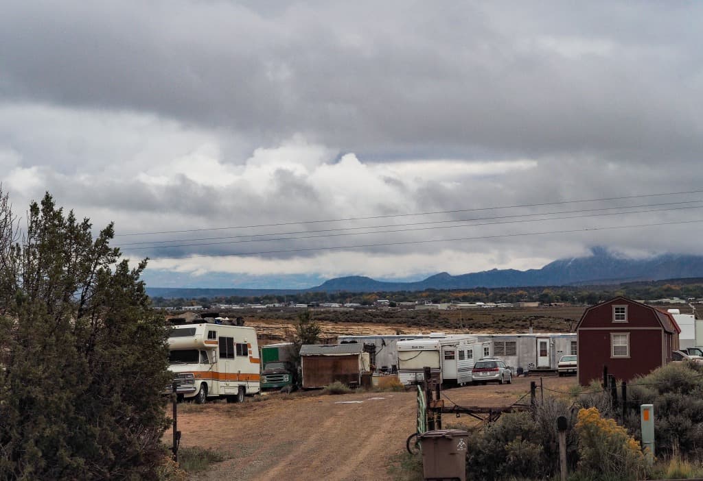
A small community of campers outside on Cortez, Colorado in October, 2021. (Dean Krakel, Special to The Colorado Sun)
Populations in many western states are increasing dramatically, putting pressure on communities to develop housing. What kind and where? And will it be in the WUI? What I like about this issue is that there are no predetermined good guys and bad guys and not much in the way of partisan vitriol (if any). Shout out to the Colorado Sun for their coverage.
Here’s one from Silverton, CO in the Colorado Sun:
Local officials are developing an attainable housing project, but for now workers have been pushed toward RVs, cars and other more desperate living situations, as a housing crunch that began years ago snowballed when urban dwellers moved to more remote locations during the pandemic.
DeAnne Gallegos, executive director of the Silverton Chamber of Commerce, is candid about how some residents are living.
“It’s glorified homelessness, let’s be honest,” she said.
Clark Anderson, executive director of Community Builders, a nonprofit helping Silverton develop a master plan, said the town and other parts of Colorado have a workforce housing market competing directly with that for high-end luxury homes. Prices overall have shot up in part due to short-term rentals, like through VRBO. Developers tend to cater to the affluent because they have investors or are trying to make a profit, he said.
“You don’t find that many developers that are going to say, ‘You know, I know that houses are selling for $1 million here but I want to really focus on building $400,000 homes,’” Anderson said.
The trend has been building for years, as communities across the West have failed to keep pace with housing demand, after overbuilding in the past.
Harper, whose family owns the Grand Imperial Hotel and the Durango & Silverton Narrow Gauge Railroad, understands why there’s so much demand for housing.
“We live and work in a postcard and we’re blessed — those select few of us that get to live here,” he said.
This Colorado Sun piece focuses on some policy solutions to the short-term rental market in mountain towns in Colorado.
Another 50 miles to the west, Reece Blincoe holed up in an RV with his 60-pound bernedoodle, Bernie, for three weeks because he couldn’t find housing before he started work as superintendent of schools in Dolores. He shuttled back and forth to a storage trailer where he kept clothes that wouldn’t fit in the RV.
“When your superintendent comes to town and has to live in an RV for three weeks, that kind of shows you what we’re dealing with here,” said Blincoe, who eventually found housing with the help of a school board member.
Lack of housing has reached a crisis point in parts of southwest Colorado, where a shortage of places to buy or rent affordably is keeping critical businesses and organizations from hiring and retaining workers. Some residents have resorted to living in cars or on campgrounds, and local officials fear middle-income earners will be priced out of the housing market.
Now the idea that people move from somewhere else, and boost prices so that residents can no longer afford to rent, and are priced out of buying, is nothing new to many places in the West. In fact, here’s a 2018 story about Californians moving to the NW and arousing local ire. Remember, in 1971, Governor Tom McCall invited tourists to visit Oregon, but then added “but for heaven’s sake don’t stay. ” And here we are, fifty years later.
Now, however, there seems to be a tension between “people shouldn’t be moving there because it’s a fire-prone landscape” and the fact that people are moving to the west because.. it’s a nice place to live, and amenity migrants particularly like being near federal lands (who wouldn’t?). The solution proposed by some is to densify western cities.
Building more dense housing units in the core of Billings, for example, could provide numerous opportunities for the community, she said, bringing more people into the heart of downtown, revitalizing the area and driving economic growth while appealing to younger workers seeking a more livable and walkable community. One focus for BSED is looking into the expansion of mixed-use properties with small businesses or retail at street level and apartments above.
“I wouldn’t say there’s any area that wouldn’t be ideal for developments,” Lehm said. “I would think we’re going to see more housing choices for downtown.”
Lehm also pointed to more innovative ways of addressing housing shortages than single-family home expansion in the suburbs. Land trusts, housing co-ops and redevelopment of downtown could all be parts of the solution. Several of those methods are being explored through small-scale programs in other Montana cities. Both Kalispell and Red Lodge have begun land trust programs to develop affordable housing.
It seems to me that there are several things about single-family homes that have made them attractive to people, ownership (not dealing with landlord-related issues; not worrying about rent going up and having to move, and so on) and space (for children, dogs, gardens, etc.). Home ownership, as Jennifer Hernandez pointed out in her piece Green Jim Crow about California, has also been the major source of wealth accumulation for people at the lower end of the economic ladder.
“about 54 percent of all renters in California, housing costs exceed 30 percent of household income, the traditional definition of housing affordability.[9]Nearly 70 percent of all state households with unaffordable housing costs consist of people of color.
Racial inequality is exponentially magnified by housing. Housing equity makes up nearly 60 percent of the total net worth of minority homeowners compared with 43 percent of White homeowner wealth.[10]Black, Latino, and other historically disadvantaged groups rely on mortgage payments to build wealth through homeownership while also paying for necessary housing; there is little to no excess cash available to buy stocks, bonds, and other assets.
So I think that having affordable single family homes is important in terms of social justice, even if the development of such housing occurs on formerly wild or agricultural land. I don’t think people think about “WUI development” necessarily in terms of affordable home ownership, but in many places it is.
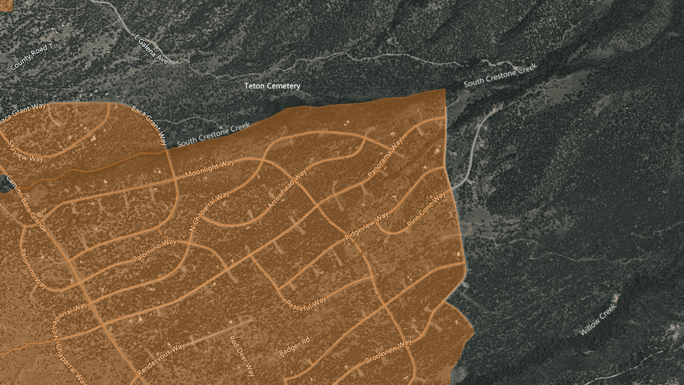
This is the 2010 map (published in 2015) of the area around Crestone, CO from the website posted yesterday.
Speaking with folks in DC last week, it sounds as if we don’t know a) if forest provisions will end up in the bill or b) which ones those are. But given that context, I’d still like to understand what they intend (ed?). But I don’t know that for sure.. perhaps someone out there has more updated information?
“$10,000,000,000 for hazardous fuels reduction projects within the wildland-urban interface;”
and this definition of WUI
(10) WILDLAND-URBAN INTERFACE.—The term ‘‘wildland-urban interface’’— 22 (A) in the case of the lower 48 States,
23 means the areas mapped as the wildland-urban 24 interface in the document entitled ‘‘The Wildland-Urban Interface of the Conterminous
United States’’, and published by the Department of Agriculture in 2015; and
3 (B) in the case of the States of Alaska and
4 Hawaii, has the meaning given the term in section 101 of the Healthy Forests Restoration 6 Act of 2003 (16 U.S.C. 6511).
So given the maps and the definitions from the 2010 mapping (published in 2015 with 2010 data) that we looked at yesterday that shows, and defines WUI, as already having houses… I wonder whether there is any NFS land in the 2010 mapped WUI to be treated?
If you’re in Alaska or Hawaii, though, apparently you get to use the HFRA definition, with which many of us are familiar (and may be the first thing that comes to mind when someone says WUI, especially related to fire).
A community gets to designate it via a CWPP (community wildfire protection plan) or otherwise it’s this default:
HFRA has a default definition of WUI (Section 101(16)(B (ii)). It is an area:
Extending 1/2 mile from the boundary of an at-risk community.
OR
Extending 1 1/2 miles from the boundary when other criteria are met—for example, a sustained steep slope, a geographic feature that could help when creating an effective firebreak, or Condition Class 3 land.
OR
Adjacent to an evacuation route. There is no distance limitation for evacuation routes.
Fortunately it appears that the at-risk community definition is the same.
“AT-RISK COMMUNITY.—The term ‘‘at-risk 6 community’’ has the meaning given the term in section 101 of the Healthy Forests Restoration Act of
8 2003 (16 U.S.C. 6511).”
So for the lower 48, clearly it was intentional to use the 2010 maps instead, but the maps may not (are likely not to?) have any FS land on them. Was this intentional, or am I misunderstanding it?
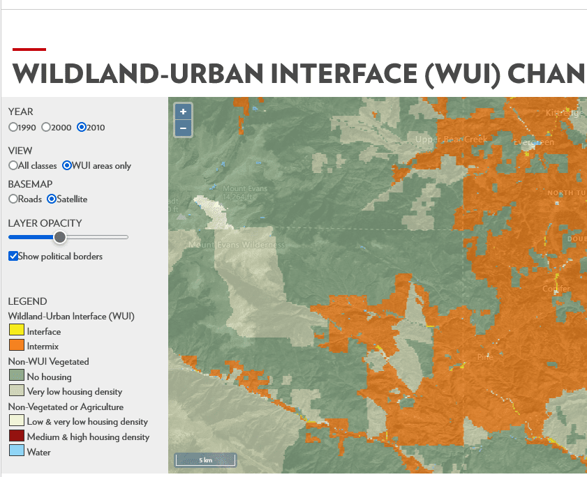
WUI map from Silvis Lab at U W Madison.. you can check out your own area. This is west of Denver.When we explore new ideas and abstractions, it’s best to start with a definition. The first and currently ongoing (updating with 2020 data as we speak) is this group at the Northern Research Station and cooperators. It should be noted that residential and other development has a host of other impacts, but this mapping is specifically designed to inform fire policy. As we noted last week, at one time the Reconciliation Bill had this map as the delineation for FS funding (that is, the 2010 mapping published in 2015) 10 billion-wise and the Sec would have to say they’d completed all those projects before the FS could use the $4 bill outside those boundaries.
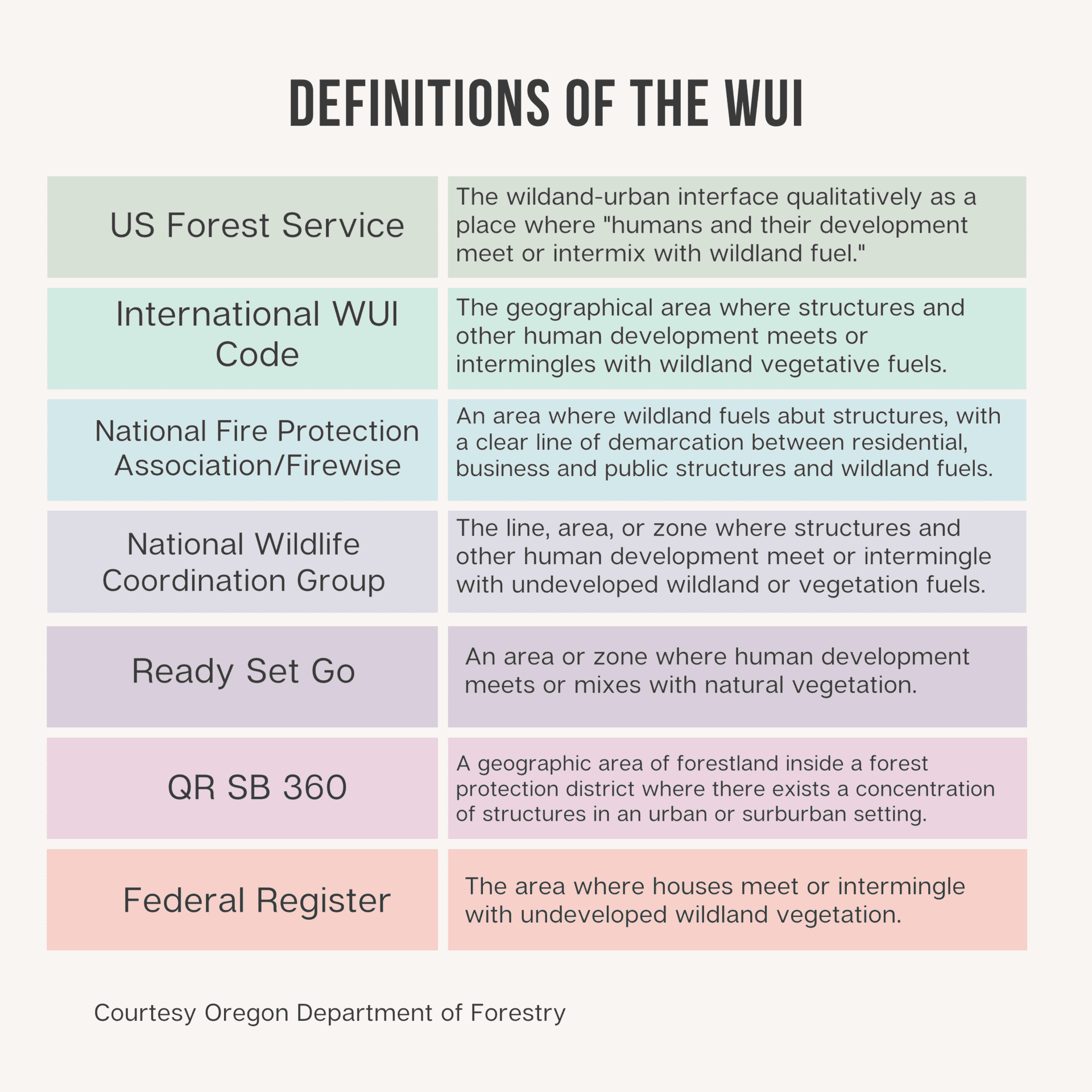
The Wildland-Urban Interface Defined
Although the idea of a wildland-urban interface is easily understood and the term widely used, a specific definition is needed to determine where it occurs and map its location. The definition we use here, as in earlier map projects, is designed to inform fire policy and management. It is based on a report prepared for the Council of Western State Foresters on WUI fire risk (Teie and Weatherford 2000) and was later published in the Federal Register. The WUI is composed of both interface and intermix communities. The distinction between these is based on the characteristics and distribution of houses and wildland vegetation across the landscape. Intermix WUI refers to areas where housing and wildland vegetation intermingle, while interface WUI refers to areas where housing is in the vicinity of a large area of dense wildland vegetation.
For more detail, see Box 1.
Box 1.—Definition of WUI and non-WUI land-use classes.
WUI Definition
Intermix Areas with ≥6.18 houses per km2 and ≥50 percent cover of wildland vegetation
Interface Areas with ≥6.18 houses per km2 and <50 percent cover of vegetation
located <2.4 km of an area ≥5 km2 in size that is ≥75 percent vegetated
Non-WUI, Vegetated
No housing Areas with ≥50 percent cover of wildland vegetation and no houses (e.g., protected
areas, steep slopes, mountain tops)
Very low housing density Areas with ≥50 percent cover of wildland vegetation and <6.18 houses per km2
(e.g., dispersed rural housing outside neighborhoods)
Non-Vegetated or Agriculture
Low and very low housing Areas with <50 percent cover of wildland vegetation and density <49.42 houses per km2 (e.g., agricultural lands and pasturelands)
Medium and high housing Areas with <50 percent cover of wildland vegetation and ≥49.42 houses density per km2 (e.g., urban and suburban areas, which may have vegetation,
but not dense vegetation)
What you might notice is that WUI on these maps can be adjacent to grazing lands or agricultural lands. Which doesn’t seem to fit the definition above, so this is more complicated than it might appear. Certainly acres of WUI next to corn fields or a grassy pasture have different fire characteristics than, say, a ponderosa forest.
This 2007 paper by Stewart et al. has a literature review and some history on the WUI concept.
Throughout its evolution, the WUI definition always includes three components: human presence, wildland vegetation, and a distance that represents the potential for effects (e.g., wildland fire and human activity) to extend beyond boundaries and impact neighboring lands. Beyond these three components, most WUI discussions are imprecise regarding what is or is not included. For example, human presence has been defined by housing density, population density, number of houses, or configuration of housing developments and neighborhood characteristics. Wildland vegetation is always mentioned, but the density, extent, and type of vegetation that makes some vegetation “wildland vegetation” is not well defined. The distance that the WUI extends into wildlands or into a housing development has been described in many different ways, including the distance a golf ball will fly off the porch or the distance from which flames or firebrands can reach a structure (Summerfelt 2003), but specific distances are rarely given.
Animated gif of the Waldo Canyon Fire Perimeter Growing
I find the abstraction of WUI enormously unhelpful to many of our discussions. Especially as sometimes conveyed not that long ago.. “the wildfire problem is due to people building in the WUI.” Then you see fires potentially coming very close to cities; Denver for the Hayman, Colorado Springs for Waldo Canyon, and then South Lake Tahoe, and actually in to Santa Rosa. Clearly people already live in the WUI. While new requirements for development would be helpful, we have to work with what we already have.
When someone write “WUI” some people are thinking (say, Colorado) McMansions in Aspen, and others mountain development with commuters to Denver, others a summer cabin near Gunnison, and others a trailer park near Florence. In no way are all those the same kind of thing, and yet, we talk about the WUI often as if it is.
These distinctions were brought to a head in my thinking by two pieces, one in High Country News and one in Harper’s.
This High Country News story’s tagline is “wildfires often hit low-income, minority communities the hardest. ” This makes sense in the narrative “climate change hurts minorities and underserved communities the worst; wildfires are due to climate change: ergo wildfires must hurt minorities and underserved the most.”
However, there is a competing narrative “WUI people deserve what they get.” This was a view before the climate change narrative took hold. I think the underlying assumption here is that WUI landowners are not poor or minorities, and that they could choose to live somewhere else, and if they did wildfires wouldn’t be as much of a problem. Of course, in many WUI communities we can look around and see that many don’t look all that well-off. Many are in subdivisions that are cheaper due to being farther out. WUI is not equal to well-off, in many cases rather the opposite. This Brookings study talks about poverty in red and blue districts, which doesn’t tease out the WUI, but it fairly interesting.
This Harpers piece is pretty hyperbolic, and perhaps an extreme example of this view.
In other words, we as a nation pay ever-mounting bills to save a comparative handful of houses owned by people who against all sane advice choose to build in the path of catastrophe. Between 1990 and 2010, a period when we should have already known better, 2 million new homes were built in the interface. These homes don’t always appear to be on the edge of the wilderness. The entirety of Seeley Lake, a town with more than 1,700 permanent residents, is located in the WUI: the main drag with its tourist trade, the sawmill at the edge of town with its 130 workers, the cabins, trailers, frame houses, the high school, Cory’s Market, the American Legion hall, and Pop’s café.
In Manning’s view, entire towns can actually be “in” the WUI. See how confusing this is?
Such policies, however, are toxic in the current political climate of the West. One can identify a conservative here simply by mentioning wildfire and waiting for the inevitable argument: “The Forest Service needs to put these fires out.” And the Forest Service does just that, as it has done for decades. (The agency, along with other federal entities and state and local crews, extinguishes about 90 percent of the many thousands of fires that occur each year on what is called initial attack, an all-out lights-and-sirens response the moment a fire is reported.) The conservatives who populate the canyons, gulches, and dead-end roads at the fringes of Western valleys are quick to put aside their customary laments about government overreach when it comes to spending billions to protect their own redoubts.
This seems kind of silly (living in the WUI=conservative) in “the West”. It’s… Montana. If that.
This might seem harsh in light of the example of California. Last year, nine thousand structures burned in the fires around Santa Rosa, and more than a thousand around Los Angeles. These were unprecedented numbers, and most of the victims committed no sin to merit this level of punishment. Nevertheless, a video clip from Santa Rosa makes a case for severe action. A reporter for NBC is doing a stand-up in front of a charred foundation that was once a home. The scene looks as you might expect, as long as you don’t look at the backdrop: a fringe of still-green trees. This image is common enough if you know what you’re looking for. Fire scientists have collections of such images, the aftermaths of fires that level entire subdivisions but leave the trees standing and green—the flames are hot enough to ignite building materials but not the surrounding flora. These aren’t forest fires; they’re subdivision fires, running house to house, fueled by bad choices in shingles.
About 30 percent of the houses that burned in one of the Santa Rosa fires, the Tubbs fire, were outside the WUI. Not in the woods. In cities. Urban. They were set alight by the burning of houses that were in the interface. Fire scientists speak of “ladder fuels,” which carry fire from one level to the next. In this case, thousands of irresponsibly built homes were the ladder fuel that destroyed houses situated in otherwise safe areas. There’s a rude and satisfying justice in burning down the house of someone who builds in the forest, but allowing his willful ignorance to destroy those of hundreds of more responsible neighbors is a travesty.
Steady on, there Mr. Manning! Sin and punishment.. isn’t that the realm of “conservatives” and their religious allies?
Perhaps we could expand it out of the West to “there’s a rude and satisfying justice in flooding the house of someone who builds along the coast.” But I don’t think that the editors of Harper’s might be as enthusiastic about that observation. Manning’s “justice” concept raised a few eyebrows when his wife, Tracy Stone-Manning, retweeted it last year and said it was a “clarion call.” To what, I am not all that clear.
But what struck me as oddest and most unusual was not that idea. We hear less hype-y (not sin and punishment) versions of that often. It was the concept that WUI people are responsible for fires moving into town. Seems like in some cases that I have noticed, a fire is coming from the forest towards town and is fought in the WUI, decreasing the chance it will get into the city. Thinking Waldo Canyon here (see photo). Maybe others have other experiences?
If we put these two articles together, we get that some people whose houses burn in the WUI are victims of climate change. Others deserve their fate. We’re using the same word to talk about vastly different people in terms of social class, race and ethnicity, cultures, history, and their physical and biological environment. Our first step in Rethinking the WUI will be to parse out some of these differences.