Does Monumentizing Really “Protect”? And Various Admin and Other Groups’ Thoughts on 30 x 30


This is the CEQ USDA DOI and Commerce joint write-up on how to achieve 30 x 30


I am going to go out on a limb here..I think the way some groups in tight with the Admin, or possibly the Admin itself (can’t easily tell), have chosen to classify federal lands for “counting” in 30 x 30 is messed up and potentially meaningless. To get started,  I think it’s important to define terms.   I’m going to capitalize Protection when I mean “protected areas as defined by various entities, that is, GAP 1 and 2, for the 30×30 effort.” In the next post, we’ll look at what’s in and what’s out based on the recent Baaj Nwaavjo I’tah Kukveni — Ancestral Footprints of the Grand Canyon National Monument (BNIK NM) declaration.  It seems to me mostly like BAU for the BLM and FS, but requiring another planning process :(.  I’m not sure that most of the reporters read the declaration itself and not just the press release.

The Center for American Progress (CAP) is a very powerful political entity and here are their policy recommendations.. it sounds like a laundry list of what the Biden Admin has been doing recently.

In a November 2022 report from its series on executive action to address the nature crisis, CAP took a deeper look at some of the most powerful conservation tools available to President Biden. In particular, the report identifies the top eight most impactful opportunities for near-term executive action. These include opportunities to designate new protected areas; expand national wildlife refuges; exclude sensitive and sacred places from drilling and mining; and establish national rules to guide conservation of U.S. Bureau of Management lands and the country’s oldest federally owned forests. In another publication from the same series, CAP highlights specific community and Tribally-led proposals for national monuments and marine sanctuaries already primed for executive action, from the proposed Avi Kwa Ame National Monument in Nevada to the Chumash Heritage National Marine Sanctuary in California. Enacting these recommendations will deliver real conservation benefits and should be prioritized.

They also indicated that to them, talking about “what counts” is beside the point.

However, heated arguments about “what counts” can miss the much bigger point behind this national “30×30” conservation goal. The ambitious 30×30 target can, and really must, be an inclusive call to action—a promise to jointly address the climate and biodiversity crises by accelerating the pace at which the country is protecting nature.

As a scientist,  I see two problems with CAP’s formulation. First, if you are indeed thinking about climate and biodiversity, then to make progress you would absolutely need to define what you want specifically, and various risks, and identify tradeoffs.  Second is that, of course, just Protecting something does not actually address both climate and biodiversity.  Not a burned tree nor a cheatgrass seed cares much about lines on maps (back to the BLM sage grouse habitat paper).

A simple example is this Oregon Public Broadcasting story about the Bootleg Fire and carbon credits (which is a good article to read anyway).  If you take out the cap’n’trade carbon credits part of the story, you have “adios, carbon we thought we had” from the area.  You can say that somehow this wouldn’t have happened if it had been in a Protected area, or somehow wouldn’t have had negative effects on biodiversity and carbon simply by drawing a line! How cool is that? But not actually real in terms of biology.

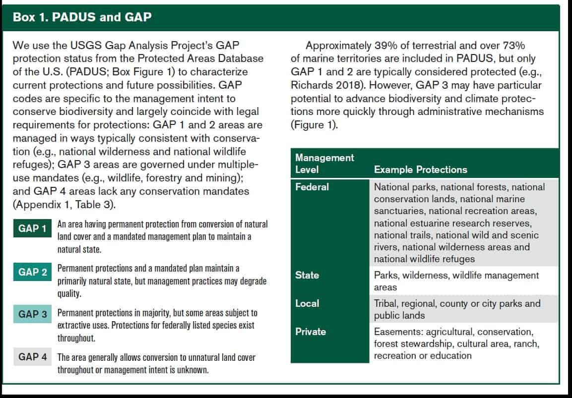
So the question that CAP raised is actually pretty important.. what’s in and out for 30 x 30? Defenders of Wildlife, for example, and the State of California, think it should only include Gap 1 and 2 acres.

*************

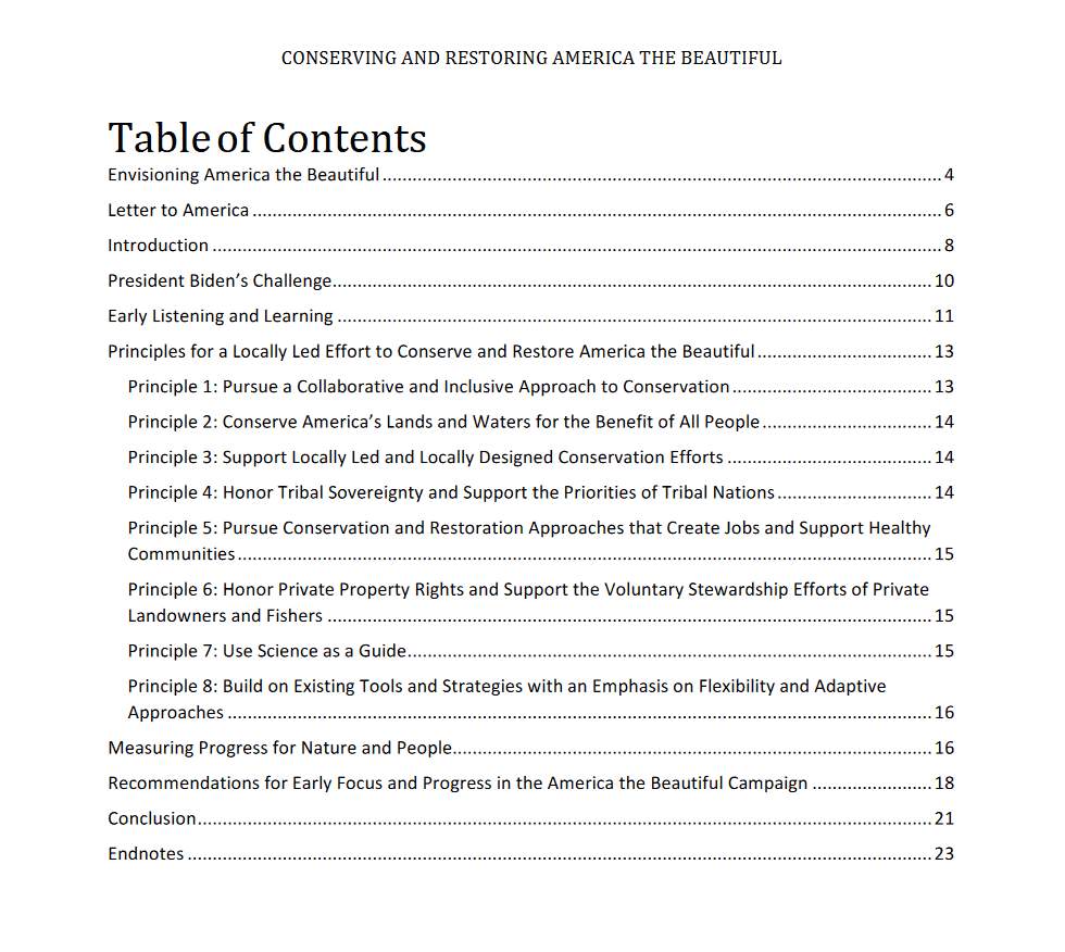
I couldn’t find a place where the Biden Admin says what counts to them  toward 30 x 30.  I did find that CEQ, Interior, USDA and Commerce wrote an interesting paper on how to achieve 30 x30 that leads with “Pursue a collaborative and inclusive approach to conservation” (see table of contents above).  There were also statements by the Admin about how working lands should count.

The interesting thing about using Gap 1 and 2, as per Defenders and others, is that, say Forest Service Roadless Areas are not included, as they are not “permanent,”  but places like the San Gabriel National Monument are included as Protected.  Having worked for years on Roadless, they seem pretty permanent to me.  I’m sure if you tried to measure “intactness” they would beat the SG National Monument or even parts of Yellowstone (Gap 1) by a mile.   It seems like a serious general flaw that these definitions consider recreation-even industrial scale- as no barrier to Protection. And in GAP1 all you need is a “management plan” to maintain a natural state.. not actually a.. “natural state” whatever that is.

Which as far as I’m concerned from any biological point of view, is pretty meaningless.  So let’s move on to the new National Monument.

Here’s a link to the Monument Proclamation- now remember that all these acres were managed by BLM and the Forest Service under their multiple- use mandate.  But GAP- wise, just the President’s signature on a piece of paper transforms them into Protected.

There’s lots of verbiage about how declaring the area a Monument will “address the legacy of dispossession and exclusion” but the actual actions in the Monument sound like BLM and FS current policy.

Conserving lands that stretch beyond Grand Canyon National Park through an abiding partnership between the United States and the region’s Tribal Nations will ensure that current and future generations can learn from and experience the compelling and abundant historic and scientific objects found there, and will also serve as an important next step in understanding and addressing past injustices.

Then they make the case for historic and scientific significance that they need to make for the Antiquities Act and to argue that 1.1 mill acres is the least amount of acres necessary  I do see this as heading to the Supreme Court if some people with lawyers care enough.

If you read through the paragraphs, it sounds like the BLM and the FS have been doing a swell job. You could also get the impression that almost any area could equally qualify with historic habitation by Native people, early Euro-American history, biodiversity and scientific interest. Here’s an example:

Protecting the areas to the northeast, northwest, and south of the Grand Canyon will preserve an important spiritual, cultural, prehistoric, and historic legacy; maintain a diverse array of natural and scientific resources; and help ensure that the prehistoric, historic, and scientific value of the areas endures for the benefit of all Americans.  As described above, the areas contain numerous objects of historic and scientific interest, and they provide exceptional outdoor recreational opportunities, including hiking, hunting, fishing, biking, horseback riding, backpacking, scenic driving, and wildlife-viewing, all of which are important to the travel- and tourism-based economy of the region.

Yup, sounds like the point is to keep protecting what the BLM and FS already protected..

Next post:  let’s see what is going to continue, and what will change, at BNIK NM.


Opponents of conservation invoke NEPA

Image: Scout Environmental

I have made several comments recently about situations that should not trigger NEPA procedures because they do not have adverse effects on the physical environment.  I became interested in this topic in 1986 when I noticed that development interests were arguing that forest plans adversely affected “community stability” (a euphemism for social and economic impacts), and this was being addressed as an “environmental” impact in NEPA documents.  Given that the goal of NEPA was better environmental protection, I could see how inferring that social and economic impacts of protecting the environment must be addressed through a NEPA process could lead to less environmental protection.

As an example of that actually happening, let’s talk about the proposal to conserve 30% of the nation’s lands (America the Beautiful/30 x 30).

Property rights advocate Margaret Byfield’s strategy for defeating the Biden administration’s aggressive conservation pledge comes with a twist: She wants landowners to embrace the nation’s bedrock environmental law.

Byfield, the executive director of American Stewards of Liberty — and daughter of the late E. Wayne Hage, an icon of the Sagebrush Rebellion II movement — sees the National Environmental Policy Act as a cudgel in her campaign to upend the “America the Beautiful” program.

But Byfield emphasized Friday that the strategy must also embrace NEPA, arguing the Biden administration has skirted its responsibility to execute “a programmatic” environmental review of its “America the Beautiful” plan.

“This is the environmentalists’ great law that they use as a weapon against productive agriculture and actually any kind of project,” Byfield said. “They use it to slow down and stop projects, they use it as a weapon.”

Byfield asserted that the Biden administration has skirted NEPA by moving forward without an environmental review.

“They also know if they do NEPA right, it’s going to take them three, maybe six, maybe nine, maybe 10 years to complete the study the way they make us do it. So why aren’t they living under the same laws they force us to follow?” she asked.

The obvious reason is that NEPA was not passed by Congress to protect “agriculture and actually any kind of project.”  The ASL seeks to turn NEPA on its head.  The interesting thing is that the Center for Biological Diversity did not mention this, instead stating that the President and executive orders are exempt from NEPA, and actually inferred that the future site-specific conservation actions could require NEPA procedures.

The law regarding application of NEPA to non-environmental consequences of environmental protection measures is less clear than it should be.  The Supreme Court framed this question in Metropolitan Edison Co. v. People Against Nuclear Energy in 1983

But we think the context of the statute shows that Congress was talking about the physical environment — the world around us, so to speak. NEPA was designed to promote human welfare by alerting governmental actors to the effect of their proposed actions on the physical environment.

But, here’s a confusing discussion by the Ninth Circuit in the 2000 case of Kootenai Tribe of Idaho v. Veneman, which challenged the procedures used to adopt the Forest Service’s Roadless Area Conservation Act (the “Roadless Rule”).  (Other plaintiffs in this case were Boise Cascade Corporation, motorized recreation groups, livestock companies, and two Idaho counties.)  The Forest Service did not appeal the district court’s injunction of the Roadless Rule, but an appeal was filed by environmental intervenors, who argued that the Rule did not alter the natural physical environment and require an EIS under NEPA.

Under NEPA, a federal agency is required to prepare an EIS for all “major Federal actions significantly affecting the quality of the human environment.” 42 U.S.C. § 4332(2)(C) (emphasis added). “Human environment,” in turn, is defined in NEPA’s implementing regulations as “the natural and physical environment and the relationship of people with that environment.” 40 C.F.R. § 1508.14. See also Wetlands, 222 F.3d at 1105. The dispositive issue here is whether the Roadless Rule sufficiently affected the quality of the human environment to trigger the procedural requirements of NEPA.

We have explained that NEPA procedures do not apply to federal actions that maintain the environmental status quo. See Burbank Anti-Noise Group v. Goldschmidt, 623 F.2d 115, 116-17 (9th Cir.1981) (NEPA does not apply when an agency financed the purchase of an airport already built); Nat’l Wildlife Fed’n v. Espy, 45 F.3d 1337, 1343-1344 (9th Cir. 1995) (NEPA does not apply when agency transferred title to wetlands already used for grazing); Bicycle Trails Council of Marin v. Babbitt, 82 F.3d 1445, 1446 (9th Cir.1996) (closure of bicycle trails does not trigger EIS). In other words, “an EIS is not required in order to leave nature alone.” Douglas County, 48 F.3d at 1505 (citation and internal quotation marks omitted). The touchstone of the EIS requirement is whether the change in the status quo is “effected by humans.” Id. at 1506.

Because human intervention, in the form of forest management, has been part of the fabric of our national forests for so long, we conclude that, in the context of this unusual case, the reduction in human intervention that would result from the Roadless Rule actually does alter the environmental status quo.

This perverse rationale (for this “unusual” case) has no citations, and I think it is only justified by a desire to decide the case on the merits of the EIS (which it upheld) rather than on a procedural question.  Moreover, it ignores the additional requirement that the environmental status quo must be adversely affected (the term “adverse” is used many times in the CEQ NEPA regulations).  Here is a 2012 paper on “beneficial effects” under NEPA.  Its conclusion echoes my concern from 35 years ago (which has become a reality).

Third, the policies underlying NEPA are in tension with a Beneficial Impact EIS requirement. Such a requirement would produce unnecessary cost and delay for environmentally beneficial projects and create perverse incentives for federal agencies without any compensating informational benefits.

Agencies that are using NEPA to justify delaying environmental protection are probably not violating the words of NEPA, but clearly violate its spirit.  Moreover, anti-environmental plaintiffs should not be able use the courts to facilitate this violation.

Conservation groups should be able to lease land to protect it

(I figured this from High Country News originally came from the Property and Environment Research Center, “the home of free market environmentalism,” and I wanted to make that clear.)

In much of the rural West, environmental groups have a reputation for suing to stop natural resource development. But some, like the Wyoming group, are attempting a new strategy: purchasing what they want to protect. The approach, sometimes called conservation leasing, could bolster “30 by 30,” the Biden administration’s ambitious conservation plan to conserve 30% of the nation’s lands and waters by 2030, without ending the leasing revenue that state governments have long derived from resource extraction.

The only problem: It’s often illegal.

These century-old “use it or lose it” requirements were designed to deter speculation and encourage white settlement. But today, they can bias resource management in favor of extraction.

We may have discussed this before, but not in the context of “American the Beautiful.”  (Note: they seem to assume that not all federal lands would automatically qualify, and that at least those committed to energy or grazing would not.)  Why not change the rules to allow non-consumptive/preservation interests to pay to prevent development (for a contractual time period that would count towards 30 x 30) on publicly owned lands?  I suppose a couple of answers are that 1) they shouldn’t have to pay, and 2) that money could be better used for something else.  But would just removing the legal barriers to allow that option to be considered in lieu of energy or grazing for areas where environmental protection is more valuable be that bad of a thing?

Federal Renewable Energy MOU

USPhoto: Joel Zwink

This article looks like an international take on U. S. renewable energy development and has links to the new MOU among five federal departments (including USDA/Forest Service) and the Energy Policy Act of 2020.  I was going to add this to Sharon’s recent post on renewable energy, but I wanted to highlight the planning implications.

This MOU implements the direction in 43 U.S.C. §§ 3001-3005, Pub. L. No. 116-260 (December 27, 2020), hereinafter “Energy Act of 2020.” Pursuant to the Energy Act of 2020, the Secretary established a National Renewable Energy Coordination Office (National RECO) within BLM Headquarters and five RECOs in the western States with responsibility to implement a program to improve Federal permit coordination for eligible “projects.”

It applies to “relevant aspects of Participating Agency coordination related to supporting activities for eligible projects—such as land use planning …,” which for the Forest Service it defines as “a land management plan approved, amended, or revised under section 6 of the FRRRPA (16 U.S.C. §1604).” (Applying this label to NFMA suggests pretty limited FS involvement.)

It requires a report to Congress identifying “outdated land use plans,” and requires BLM (but not the Forest Service) to “identify land use plans that may need to be amended as part of the decision-making process to consider eligible projects…”  But maybe BLM will identify outdated Forest Service plans.

I hope this right hand of our government (a legacy from the prior administration) is talking to the left hand about where it wants to conserve 30% of the land.

Science Friday: Law et al. Paper on Prioritizing Forest Areas for Protection in 30 x 30

We’ve looked at two scientific papers in the last week,  last Friday Siirila-Woodburn et al.   “low to no snow future and water resources” as we discussed here.  Then yesterday we took a look at Ager et al. 2021. as part of a discussion about the Forest Service 10 year wildfire risk reduction plan.  Today I’d like to look at a recent paper by Law et al. that Steve brought up in a comment yesterday. It’s interesting for many reasons, not the least of which is that the journal, Communications Earth and Environment publishes the review comments and responses, and is open access. Apologies for the length of this post, but there’s lots of interesting stuff around this paper.

The first question is “what is the point of the paper?”  In the discussion, the authors say

“We developed and applied a geospatial framework to explicitly identify forestlands that could be strategically preserved to help meet these targets. We propose that Strategic Forest Reserves could be established on federal and state public lands where much of the high priority forests occur, while private entities and tribal nations could be incentivized to preserve other high priority forests. We further find that preserving high priority forests would help protect (1) ecosystem carbon stocks and accumulation for climate mitigation, (2) animal and tree species’ habitat to stem further biodiversity loss, and (3) surface drinking water for water security. Progress has been made, but much work needs to be done to reach the 30 × 30 or 50 × 50 targets in the western US.”

Basically, to put words in their mouths, they used geospatial data from various sources to help figure out how to meet 30×30 and 50×50 goals. It seems to me that they equate “preervation” to “conditions that are good for carbon stocks, biodiversity, and drinking water.”  This is perhaps fine in a non-fire environment (and we can all make assumptions about future fires on the West Side, but if we were perfectly honest we’d admit that “fires may well occur on the west side as well and possibly increase” but “no one knows for sure.”

Now if we were to raise our sights from the details of the geospatial framework, we might see that 30 x 30 is a current policy discussion about how much conservation versus protection and what practices count.  So they might have taken the same tack as Siirila-Woodburn and Ager’s coauthors.. “let’s ask the people who know about these practices and are working in the area what they would like to know that would help them. Keeping in mind that these systems are so complex, we can’t really predict and need to be open about uncertainties.” There’s also a substantial literature about these national or international priority setting analyses, and their tendencies to disempower local people. No reviewers of this paper that I could tell were social scientists.

Nevertheless, it seems like they ran some numbers, and then had a long discussion in a mode of an op-ed with citations.

Differences in fire regimes among ecoregions are important parts of the decision-making process. For example, forests in parts of Montana and Idaho are projected to be highly vulnerable to future wildfire but not drought, thus fire-adapted forests climatically buffered from drought may be good candidates for preservation. Moist carbon rich forests in the Pacific Coast Range and West Cascades ecoregions are projected to be the least vulnerable to either drought or fire in the future25, though extreme hot, dry, and windy conditions led to fires in the West Cascades in 2020. It is important to recognize that forest thinning to reduce fire risk has a low probability of success in the western US73, results in greater carbon losses than fire itself, and is generally not needed in moist forests79,80,81,82.

Biodiversity- wise, though, you don’t need a PhD in wildife ecology to think.. protecting more west-side Doug-fir isn’t as good for biodiversity as protecting some of that and some of Montana or New Mexico.. so really carbon and biodiversity don’t always lead us to the same places.  It’s interesting that the reviewers didn’t catch the claim that “forest thinning has a low probability of success” What is paper 73, you might ask?  It’s a perspective piece in PNAS (so another op-ed with citations) by our geography friends at University of Colorado.  And “results in greater losses than fire itself?”  See our California versus Oregon wildfire carbon post here.

Forests help ensure surface drinking water quality63,64 and thus meeting the preservation targets would provide co-benefits for water security in an era of growing need.

This was an interesting claim for “protected” forests, as our hydrology colleagues (who perhaps are more expert in this area?) wrote in their review..

Changes in wildfire frequency, severity and timing are particularly catastrophic consequences of a low- to- no snow future. Indeed, alongside continued warming, a shift towards a no- snow future is anticipated to exacerbate wildfire activity, as observed169,170. However, in the longer term, drier conditions can also slow post- fire vegetation regrowth, even reducing fire size and severity by reducing fuels. The hydrologic (and broader) impacts of fire are substantial, and include: shifts in snowpack accumulation, snowpack ablation and snowmelt timing171; increased probability of flash flooding and debris flows172,173; enhanced overland flow; deleterious impacts on water quality 174,175; and increased sediment fluxes176,177. Notably, even small increases in turbidity can directly impact water supply infrastructure178,179. Vegetation recovery within the first few years following fire rapidly diminishes these effects, but some longer term effects do occur, as evidenced with stream chemistry180 and above and below ground water partitioning both within and outside of burn scars181.

There’s even a drive-by (so to speak) on our OHV friends..

Recreation can be compatible with permanent protection so long as it does not include use of off-highway vehicles that have done considerable damage to ecosystems, fragmented habitat, and severely impacted animals including threatened and endangered species37

Here’s a link to the review comments. The authors did not include fragmentation in their analysis as one reviewer pointed out, so they added

Nevertheless, our current analysis did not incorporate metrics of forest connectivity39 or fragmentation48, thus isolated forest “patches” (i.e., one or several gird cells) were not ranked lower for preservation priority than forests that were part of large continuous corridors.

To circle back to handling uncertainty and where the discussion of these uncertainties takes place (with practitioners and inhabitants or not), another review comment on uncertainty and the reply:

The underlying datasets that we used in this analysis did not include uncertainty estimates and thus it is not readily possible for us to characterize cumulative uncertainty by propagating uncertainty and error through our analysis. We recognize the importance of characterizing uncertainty in geospatial analyses and acknowledge this is an inherent limitation in our current study. To better acknowledge this limitation and the need for future refinements, we added the following text to the end of the Discussion (lines 445-447): Next steps are to apply this framework across countries, include non-forest ecosystems, and account for how preservation prioritization is affected by uncertainty in underlying geospatial datasets.

It makes me hanker for old timey economists, who put uncertainties front and center. Remember sensitivity analysis?

But the reviewers never addressed the gaps that I perceive between what the authors claim in their discussion and what the data show. I suspect that’s because “generating studies using geospatial data” is a subfield, and the reviewers are experts in that, but the points in the discussion (what’s an IRA, what’s the state of the art on fuel treatments) not so much. I think that that’s an inevitable part of peer review being hard unpaid work- at some point reviewers will use the “sounds plausible from here” criterion. And so it goes..

Large landscape connectivity – could the Forest Service be a leader?

I watched a webinar provided by the Center for Large Landscape Conservation titled “Legal Protections for Large Landscape Conservation,” part of which focused on “Habitat Connectivity and the U. S. Forest Service.”  That segment can be seen here from 4:15 to 19:05.  The presentation goes over the elements of Forest Service planning that could be useful for habitat connectivity.  It includes a couple of examples of “innovations” from the Flathead and Carson/Santa Fe forest plan revisions, but concludes that few plan components that address connectivity are likely to be very effective.  It cites a familiar refrain that the agency is “unwilling to commit to specific direction,” and “lack of commitment and interest from line officers.”  However, the presenter observed that the movement of the Forest Service toward more centralized planning organizations might provide an opportunity to look at connectivity as a broader regional issue, and to develop regionally consistent approaches to planning for connectivity.

What if the Forest Service was actually interested in conserving the species that use its lands but require connectivity across other jurisdictions and ownerships (as it is required to do, “in the context of the broader landscape,” a phrase used seven times in the 2012 Planning Rule ), and what if the Forest Service played a leadership role in facilitating such cross-boundary connectivity by promoting large-landscape conservation strategies?

Maybe it would look something like what the Yellowstone to Yukon Initiative has accomplished since it began promoting large-scale landscape conservation in 1993.  As Rob Chaney reports in the Missoulian, they have recently evaluated the effectiveness of their program in “Can a large-landscape conservation vision contribute to achieving biodiversity targets?”  They found that in the Y2Y region where landscape connectivity was actively promoted, more public lands were dedicated to protection, more private lands were protected, wildlife highway crossing structures proliferated, and occupied grizzly bear habitat (as a proxy for actual benefits to wildlife) expanded.

Come to think of it, wouldn’t that be a great assignment for the Biden Administration to give the Forest Service (both the National Forest System and State and Private Forestry divisions) to promote its 30 X 30 conservation agenda?


Conservation works better when local communities lead it, new evidence shows

I received a link to this article just about the same time I was hearing about the re-Monumentization effort and the language of the Reconciliation bill.  Another Biden Administration claim, for example,  here “promise that they would summon “science and truth” to combat the coronavirus pandemic, climate crisis and other challenges.” And that raises the question of course “what specific scientific studies support this claim?” and “who determines what is truth?” What’s the role of “science” compared to other views and interests?

Here’s a link to a Conversation article.

And here’s the abstract.

Debate about what proportion of the Earth to protect often overshadows the question of how nature should be conserved and by whom. We present a systematic review and narrative synthesis of 169 publications investigating how different forms of governance influence conservation outcomes, paying particular attention to the role played by Indigenous peoples and local communities. We find a stark contrast between the outcomes produced by externally controlled conservation, and those produced by locally controlled efforts. Crucially, most studies presenting positive outcomes for both well-being and conservation come from cases where Indigenous peoples and local communities play a central role, such as when they have substantial influence over decision making or when local institutions regulating tenure form a recognized part of governance. In contrast, when interventions are controlled by external organizations and involve strategies to change local practices and supersede customary institutions, they tend to result in relatively ineffective conservation at the same time as producing negative social outcomes. Our findings suggest that equitable conservation, which empowers and supports the environmental stewardship of Indigenous peoples and local communities represents the primary pathway to effective long-term conservation of biodiversity, particularly when upheld in wider law and policy. Whether for protected areas in biodiversity hotspots or restoration of highly modified ecosystems, whether involving highly traditional or diverse and dynamic local communities, conservation can become more effective through an increased focus on governance type and quality, and fostering solutions that reinforce the role, capacity, and rights of Indigenous peoples and local communities. We detail how to enact progressive governance transitions through recommendations for conservation policy, with immediate relevance for how to achieve the next decade’s conservation targets under the UN Convention on Biological Diversity.

Now there’s at least two interesting things about this paper. It uses “Indigenous and local communities” as a unit. Here within the US, there seems to be great interest in empowering Indigenous communities (at least as long as they agree with certain interests) but perhaps, not so much, local communities. If a community doesn’t want, say, wind turbines, they may be called NIMBY’s. If they do want to produce wood products, they are not in the pockets of extractive interests. And I know that people in local communities disagree among themselves, as do Native Americans. And who wins is ultimately a political/privilege question. Still, I think this would argue for some kind of process that involves all these affected parties directly and transparently.

In the paper, conservation is a bigger idea than what we might think of conservation.. it’s kind of “everything good.”

This review builds on the idea that beyond its environmental objectives, conservation serves to support the rights and well-being of IPLCs. We wish to explore not only the social outcomes of conservation, but also the social inputs, including values, practices, and actions (specifically of IPLCs) that may shape the social and ecological outcomes of conservation. In so doing, we adopt a definition of well-being that is holistic and adaptable to different contexts, encompassing not only material livelihood resources such as income and assets but also health and security as well as subjective social, cultural, psychological, political, and institutional factors (Gough and McGregor 2007). All of the latter elements are increasingly considered as potential social impacts of conservation (Breslow et al. 2016).

(my bold)

It strikes me in focusing on local-led efforts, the Biden Admin 30×30 is following along with these concepts (perhaps “the science”). On the other hand, there appear to be political forces at work to assuage interests who feel quite differently about local processes and involvement (not sure what degree of Tribes), as per re-Monumentization and the Reconciliation bill. It will be interesting to watch how the Administration navigates these tensions through time.

The Princeton Study, Solar and Wind Buildout and Landscape Transformation (Including Federal Lands)

Retired Smokey Bear commented about the proposed buildout of wind and solar in Virginia, which reminded me of the Princeton study. There’s a good New York Times article, which probably has a paywall but I included some maps and excerpts from there.  You can check out the Princeton study itself here.  It’s jam-packed with information of all kinds.

The Princeton study has several scenarios, and the maps here are based on the “Princeton Net-Zero America High Electrification scenario, which assumes that the United States will essentially phase out coal use and drastically reduce natural gas and oil use. The scenario also assumes the United States will use geologic sequestration to capture and store one metric gigaton of carbon each year by 2050. It also assumes there will be widespread adoption of electric vehicles in 2050 and high levels of building electrification.”

I believe you can scroll down on the maps to see your own part of the country, but I couldn’t figure out how. That’s why I’m using the NY Times maps below, for which wind is blue and solar is orange. Note that western forested areas in the PNW and northern California don’t have much to speak of, but for the interior West is looks like overlap with sage grouse terrain. Also note the midwest and east coast.  It seems that the brunt of this buildout will not occur on the coasts (except offshore) so there could be an element of Coastalism that crops up as the buildout occurs (if it does). If you read the comments, it looks like many think alternatives are rooftop and along existing highways and other previously manipulated habitat. If you didn’t think decarbonizing is ultimately an engineering/construction practical problem, this discussion might lead you there. Or back to nuclear. Which reminds me of this effort in Wyoming, which is being built to access the infrastructure and workforce of an existing coal mine.

Wind and solar needed by 2050 (NY Times map)
Solar and Wind today (from the NY Times)

Getting the permits

And back to our federal landscapes concerns.

Many of the places with the best sun and wind resources in the United States are on public land in the southwest and along the Rocky Mountains, so some energy will still need to come from remote areas in the West.

Getting approval to build on federal or state land can be a much longer process than what’s required for private land.

The Interior Department currently has a goal of approving permits for 25 gigawatts of renewable energy on federal land by 2025, but some of the Princeton models propose nearly five times that amount on public land in the coming decades.

How much energy is allowed on public land, and where projects are built, will depend on how the Biden Administration updates the solar and wind energy plans developed during the Obama administration. Those projects allow fast-tracked permitting for renewable projects on certain parcels of federal land for projects.

The existing plans, nearly a decade old, will need to be updated to account for advances in solar and wind technology that allow projects to be built on steeper terrain or to have less of an environmental impact.

Conservation

The question of whether to strictly conserve land for environmental purposes or make exceptions for clean energy is a thorny one.

Some species, like the desert tortoise and sage grouse, are being pushed to the brink of extinction by global warming and development, including oil and gas extraction, in their habitats. Without careful planning, adding vast solar panel arrays or hundreds of wind turbines where they live could push them over the edge. But so, too, could the continued burning of fossil fuels and rising global temperatures.

Renewable energy developers are required to conduct environmental impact studies and can sometimes offset the harm from new projects. A developer hoping to build wind turbines, for example, could pay to retrofit older, existing transmission lines in the area to make them safer for birds, balancing the toll on the species.

I think solar and wind installations are out for any 30 x 30 initiatives, so those efforts will also reduce the acres available. Perhaps it would make sense to start a national discussion now and delineate zones for solar and wind and transmission, and then start 30×30 ing.

Practice of Science Friday: Getting to Co-Design and Co-Production of Climate Models

From Meadow et al.
https://journals.ametsoc.org/view/journals/wcas/7/2/wcas-d-14-00050_1.xml

We’ve been discussing the RCP 8.5 issue in climate modeling, this week and earlier, which reminded me of this story. A few years ago, I attended a reunion (my class’s 40th) at the Yale School of Forestry (cl and Environmental Studies (now School of the Environment). Jerry Melillo, of Woods Hole, gave a talk about climate modelling.

Jerry showed a slide of “protected areas,” and of course, having worked on the Colorado Roadless Rule for years, I could see from the map that I might not agree with the boundaries. At least not in terms of physically meaningful differences for input into climate models. Imagine how hard it would be to take the non-Wilderness parts of your neighboring forest and make assumptions about what they would or would not contribute to climate change in the next fifty years or more? My question to Jerry was “forest management is a sliding scale, from planting trees after fires and leaving them alone thereafter, to intensive forest management as practiced in the southeastern US with loblolly pine. It’s a dial not a toggle, so how do models of future land use reflect that?” His answer was that IUCN had made the determination of what was protected, and he was using their numbers. Of course, determining something is a toggle when it is a dial is a value judgment, not a scientific finding. And folks might choose toggle due to computational convenience, not proximity to validity.

Roger Pielke, Jr. and Justin Ritchie wrote a comprehensive historical account of the development and use of RCP’s, including definitions of the relevant jargon. From a history of science/sociology of science perspective. It has been the best guide I’ve found to try to understand “is our work (land-use) an input, output or both?” There are even flowcharts! Roger and Justin have a few suggestions (these are only some):

*Despite the presence of thousands of IAM scenarios in the community, and the motivation to proceed with ‘one model one vote’ dynamics where all models are assessed equally with no explicit probability statements, more regular attention needs to be given to a much simplified set of near-term, policy relevant scenarios, similar to how IEA issues three scenarios on an annual basis: a Current Policies Scenario (high), a Stated Policies Scenario (baseline) and a Sustainable Development (policy) scenario.

(I see this as fewer but more realistic options, done more frequently to reflect changes and course-correct assumptions, some of the same preferences we would have for any planning effort.)

*More work is needed to reconcile long-term narrative pathways based on an idealized year 2100 end-point with what policy makers need to know about the next few years and decades. While there are an increasing number of scenarios focused on the role of Paris Agreement NDCs through 2030, there is a significant gap in the literature for scenarios that address developments before 2050 in the context of today’s policy environment. This gap is created by an excessive focus on long-run, full century scenarios, driven in large part by the needs of the physical science modeling community.

There seems to be a need for policy folks to say “nope, that solution isn’t working for us, how about trying …?” Not sure that there is the direct connection among groups for this discussion to take place. Remember the idea of “co-designed, co-produced research” with stakeholders and policy makers?

* Climate research and assessment would benefit from a more ecumenical and expansive view on relevant knowledge. The IPCC scenario process has been led by a small group of academics for more than a decade, and decisions made by this small community have profoundly shaped the scientific literature and correspondingly, how the media and policy communities interpret the issue of climate change. The dominant role of this small community might be challenged in order to legitimize a broader perspective of views, approaches and methods.

It would be handy IMHO if that were to be a role of (at least some of) the new climate $ in the President’s budget proposal. I can imagine a multi-stakeholder group at the regional level asking questions like “what do we want from climate models to help us plan mitigation and adaptation strategies?”. How can we use our local and regional knowledge as input into the process? What have scientists learned that can be helpful to us, and what else do we need to know?

As it turns out there is quite a bit of literature on co-design and co-production of climate science. You can go into Google Scholar and search on “climate science co-production.” That’s how I found the Alison et al. paper that yielded the Table 2 above.