I was curious about what the FS is doing so looked it up here on the USDA list.
Below are the FS entries.. my instinct would say that there are probably more, at least in R&D, that use machine learning.
| Development and Acquisition | In-house | |||||||
| Ecosystem Management Decision Support System (EMDS) | USDA | Forest Service | EMDS is a spatial decision support system for landscape analysis and planning that runs as a component of ArcGIS and QGIS. Users develop applications for their specific problem that may use any combination of four AI engines for 1) logic processing, 2) multi-criteria decision analysis, 3) Bayesian networks, and Prolog-based decision trees. | Operation and Management | Contracted | |||
| Wildland Urban Interface – Mapping Wildfire Loss | USDA | Forest Service | This is a proof-of-concept study to investigate the use of machine learning (deep learning / convolutional neural networks) and object-based image classification techniques to identify buildings, building loss, and defensible space around buildings before and after a wildfire event in wildland-urban interface settings. | Development and Acquisition | In-house | |||
| CLT Knowledge Database | USDA | Forest Service | The CLT knowledge database catalogs cross-laminated timber information in an interface that helps users find relevant information. The information system uses data aggregator bots that search the internet for relevant information. These bots search for hundreds of keywords and use machine learning to determine if what is found is relevant. The search engine uses intelligent software to locate and update pertinent CLT references, as well as categorize information with respect to common application and interest areas. As of 2/24/2022, the CLT knowledge database has cataloged >3,600 publications on various aspects of CLT. This system fosters growth of mass timber markets by disseminating knowledge and facilitating collaboration among stakeholders, and by reducing the risk of duplication of efforts. Manufacturers, researchers, design professionals, code officials, government agencies, and other stakeholders directly benefit from the tool, thereby supporting the increasing use of mass timber, which benefits forest health by increasing the economic value of forests. | Operation and Management | Contracted | |||
| RMRS Raster Utility | USDA | Forest Service | RMRS Raster Utility is a .NET object oriented library that simplifies data acquisition, raster sampling, and statistical and spatial modeling while reducing the processing time and storage space associated with raster analysis. It includes machine learning techniques. | Operation and Management | In-house | |||
| TreeMap 2016 | USDA | Forest Service | TreeMap 2016 provides a tree-level model of the forests of the conterminous United States. It matches forest plot data from Forest Inventory and Analysis (FIA) to a 30×30 meter (m) grid. TreeMap 2016 is being used in both the private and public sectors for projects including fuel treatment planning, snag hazard mapping, and estimation of terrestrial carbon resources. A random forests machine-learning algorithm was used to impute the forest plot data to a set of target rasters provided by Landscape Fire and Resource Management Planning Tools (LANDFIRE: https://landfire.gov). Predictor variables consisted of percent forest cover, height, and vegetation type, as well as topography (slope, elevation, and aspect), location (latitude and longitude), biophysical variables (photosynthetically active radiation, precipitation, maximum temperature, minimum temperature, relative humidity, and vapour pressure deficit), and disturbance history (time since disturbance and disturbance type) for the landscape circa 2016. | Operation and Management | In-house | |||
| Landscape Change Monitoring System (LCMS) | USDA | Forest Service | The Landscape Change Monitoring System (LCMS) is a National landsat/sentinal remote sensing-based data produced by the USDA Forest Service for mapping and monitoring changes related to vegetation canopy cover, as well as land cover and land use. The process utilizes temporal change classifications together with training data in a supervised classification process for vegetation gain, and loss as well as land cover and use. | Development and Acquisition | In-house | |||
| Geospatial and Remote Sensing Training Courses | USDA | Forest Service | Several courses are offered which teach the use of software and scripting which allow for machine learning. The courses change, but current topics include Intro and Advanced Change Detection, eCognition (software package), Geospatial Scripting for Google Earth Engine. Some of the courses show how to use Collect Earth Online. | Operation and Management | In-house | |||
| Forest Health Detection Monitoring | USDA | Forest Service | Machine learning models are used to (1) upscale training data, using Sentinel-2, Landsat, MODIS, and lidar imagery, that was collected from both the field and high-resolution imagery to map and monitor stages of forest mortality and defoliation across the United States, and (2) to post-process raster outputs to vector polygons. | |||||
Here’s a link to the GAO report. I have some concerns about AI use, as it is another layer between the real world and decisions by humans. If trust is about transparency and accountability, we’d want to make sure that the uses and what’s under the hood would be publicly reviewed..regularly. “Whoops, the AI told us to!” might become an off-ramp for accountability for, say, fire errors and make “lessons learned” the domain of the app and not firefighters. What could go wrong? I imagine many things. Seems like there might need to be a discussion around “social license” with this technology.
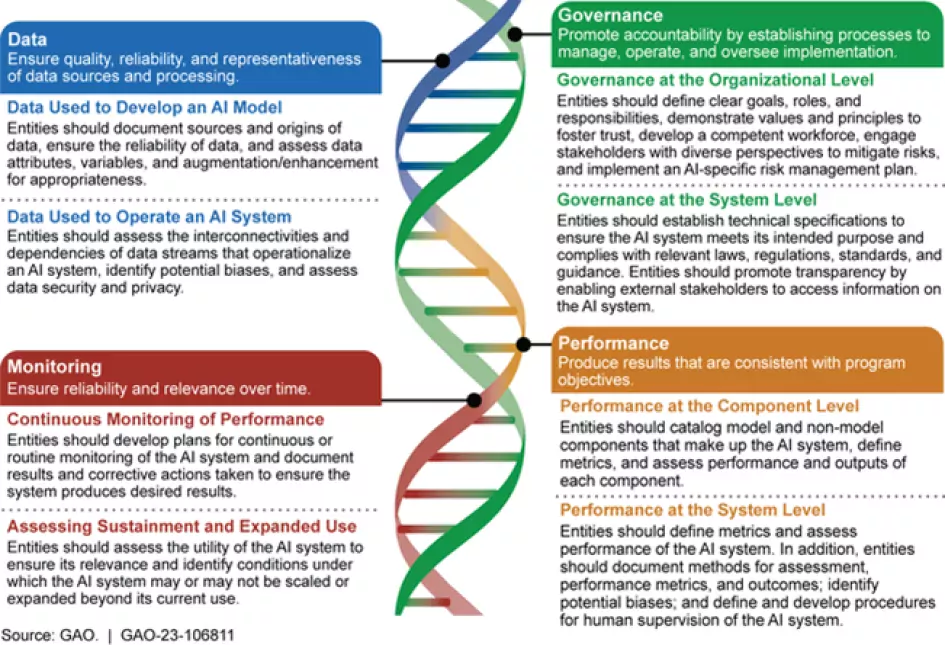
There’s actually an AI Accountability Framework:This is pretty common-sensical, but it seems like we have more government employees, contractors and partners, in general describing what other people should do rather than actually doing anything, making sure that contractors are doing things, or checking on their work. And it does mention “engaging stakeholders.”
As AI technologies continue to advance at an incredible speed, federal oversight needs to evolve alongside them. GAO’s AI accountability framework can help federal agencies and others use AI responsibly.
This framework is organized around four complementary principles:
- Governance—promote accountability by establishing processes to manage, operate, and oversee implementation
- Data—ensure quality, reliability, and representativeness of data sources and processing
- Performance—produce results that are consistent with program objectives
- Monitoring—ensure reliability and relevance over time
AI Accountability Framework
I thought that this was interesting from the new report:
“Commerce reported the use of AI for satellite-based fire detection and intensity products combined with fuel, elevation, and weather data to determine the probability of rapid intensification and spread of wildfires.”
Commerce? Was that an error? Maybe Congress could ask GAO (or an AI app for GAO) to identify how many agencies are funding what appear to be identical scientific projects?Anyway, here are some background info I selected from the GAO report.