Eastern Colorado BLM RMP Strikes a Balance; Both Wildlife and Energy People Satisfied; District Manager Explains Rationale

First thing.. this RMP covers more subsurface mineral estate than surface

The Eastern Colorado RMP planning area consists of approximately 35 million acres of land under various jurisdictions in eastern Colorado, including 7,177,100 acres of federal mineral estate, which may lie beneath other surface ownership. The BLM actions considered in the Approved Eastern Colorado RMP would only apply to those areas for which the BLM has the authority to make management decisions (the decision area), which comprise 658,200 acres of BLM-administered surface land and 3,311,900 acres of BLM-administered mineral estate.

If you’re interested, I posted some maps below.

According to TRCP,  the fact that there was a South Park Coalition made the difference.

Before the formal planning process began, Park County, Colorado Wildlife Federation, TRCP, several other conservation organizations, and water providers came together as the South Park Coalition and began identifying areas suitable for development and areas key to conserve.

“I think the work we did well before the formal process made a big difference to enable the really good outcome for the unique resources of the South Park area,” said Suzanne O’Neill, executive director of the Colorado Wildlife Federation. “We applaud BLM’s recognition throughout the process of this iconic basin’s distinctive and largely unfragmented wildlife habitats, prized trout streams, water quality, and spectacular vistas. In addition, the plan’s treatment of the areas managed by BLM in eastern Colorado outside of South Park has been much improved.”

This is a good story from the Colorado Sun.  Apparently CBD is not a fan.

“Unfortunately, the BLM maintains the status quo, which is basically the oil and gas industry can have whatever it wants, whenever it wants, and however it wants,” said Nichols, whose group estimates the plan allows for a doubling of oil production on public lands over 20 years. “And that is not a solution to both the climate crisis or the clean air crisis that is affecting the Denver Metro area and the Northern Front Range.”

And many wildlife groups and the energy folks are satisfied.

“BLM chose a balanced alternative, not the most extreme conservation-only alternative,” said Kathleen Sgamma, president of the Western Energy Alliance. Of course some environmental advocates are not happy, she said, because they are “never happy unless a decision is made that shuts off all oil and natural gas, but that would be unlawful. BLM has a duty to balance energy development with environmental protection.”

I thought what the Royal Gorge District Manager had to say was interesting:

The BLM’s Royal Gorge district office, which guided the resource plan, said the draft process included a long schedule of community meetings for input. The BLM’s call for public involvement included a first-time effort to divide the broad swath of Colorado into four geographic regions with a unique sense of geography and culture. South Park community advocates had a big impact on the plans, Royal Gorge district manager Keith Berger said.

The early 2019 draft of the now-final plan had only about 1,300 acres set aside for land with wilderness characteristics, Berger said, and public calls for more eventually pushed the BLM to set aside more than 114,000 acres in that protected category.

Oil and gas development was taken off the table for 93% of the Eastern Colorado land, he added. (Nearly all the mineral rights BLM deals with in Eastern Colorado are oil and gas, rather than coal rights the agency controls in other districts.) BLM decided to allow new oil and gas development in northeast Colorado, for example, in part because those areas already have oil and gas as a common land use, he said. Much of the BLM-controlled mineral right is interspersed with private lands where oil and gas drilling is already dominant.

If BLM stops new leasing, the technology of fracking allows a private well nearby to reach underground and take federal resources without compensating the U.S. taxpayer through royalties, Berger noted.

“It sets up a scenario where the federal mineral estate would still be drained by that adjacent development going on on private lands,” he said.

If that’s true,  then can what Ramey says here be equally true?

“While we celebrate the new lands protections, it’s confounding that the final plan will increase climate-damaging emissions,” said Jim Ramey, Colorado State Director for The Wilderness Society. “

Do Ramey and CBD disagree that the gas will be extracted either way? I would have asked, since both of their statements would not be true if that is the case (increase emissions). Aside from the whole “reducing emissions by keeping fossils in the ground in the US is the best way to reduce global emissions” argument which I don’t agree with.

Anyway, check it out.    It does make you wonder whether there might be a partisan subtext to choosing the preferred alternative in Wyoming.


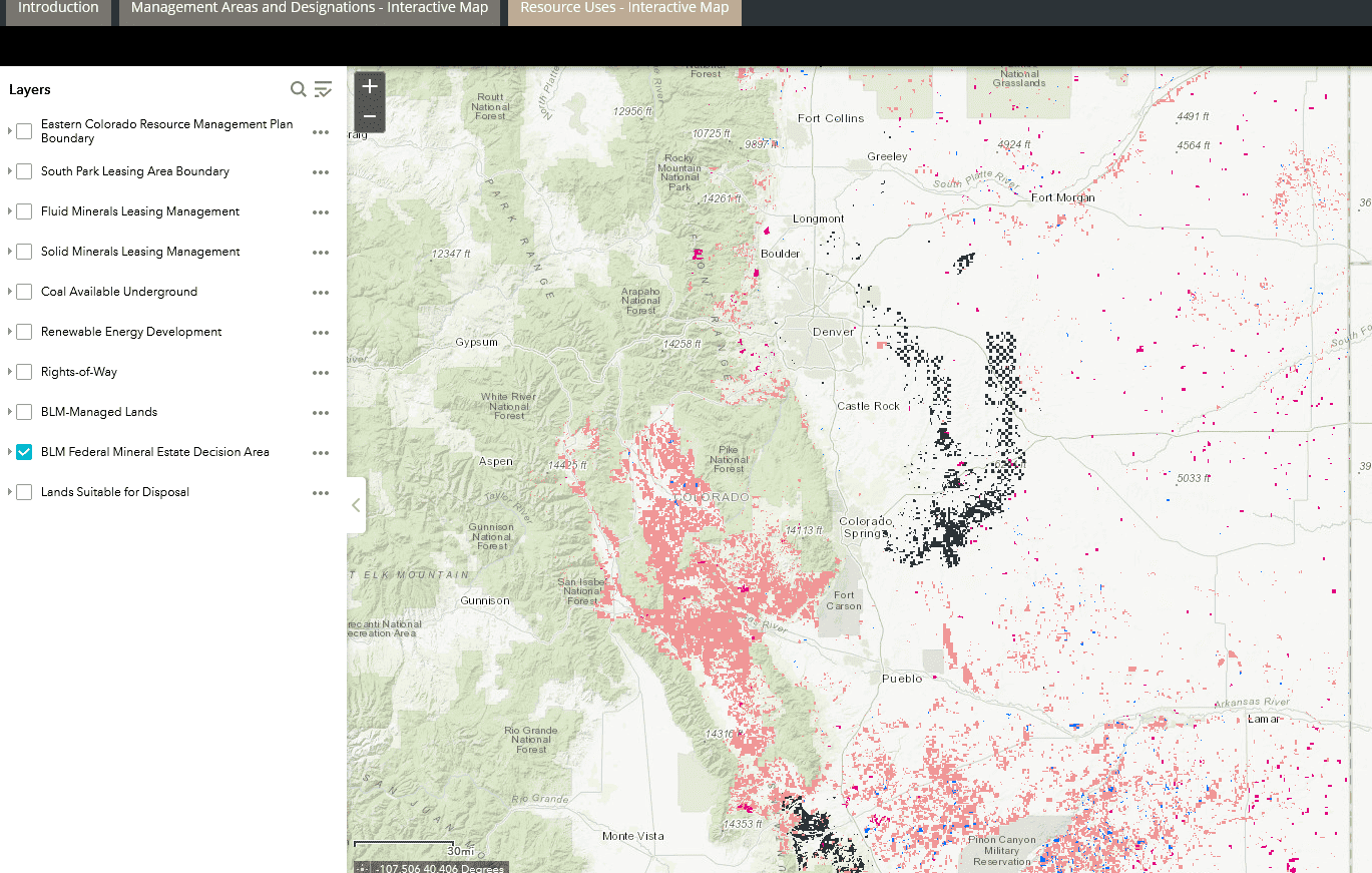
It’s a little confusing, because to Coloradans, “eastern Colorado” is not in the mountains, whereas most of the BLM surface in this RMP is.  Here’s the surface estate:

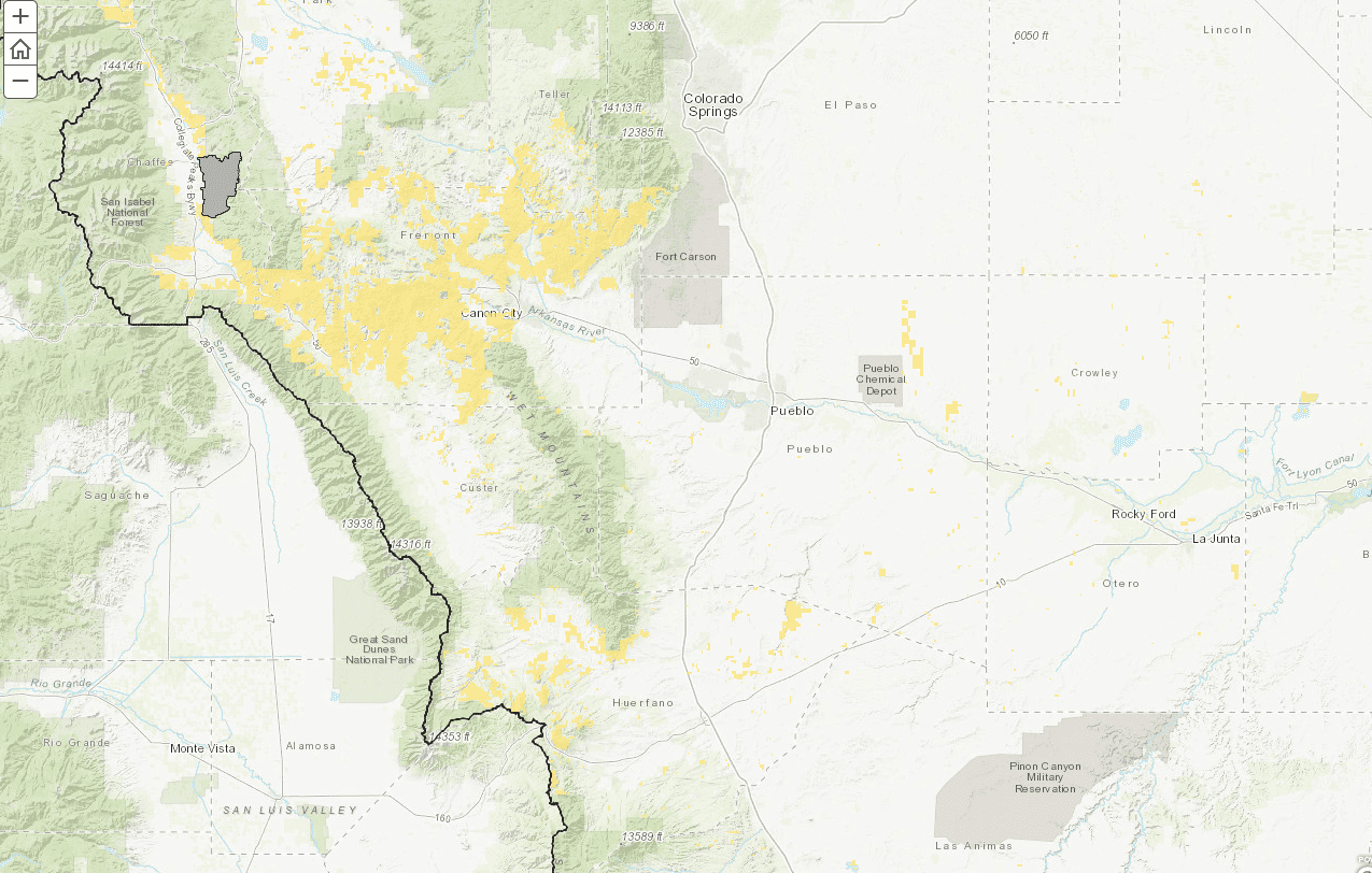
If I used the eplanning site correctly, here’s the subsurface estate. I haven’t figured out the red vs. black. Maybe someone can help?


M

BLM Stories: Cassia County (Idaho) Flood of 1984 by Steve Ellis


Steve Ellis (middle back row) at the time.

Timeline: The 1984 drama at Lower Goose Creek Reservoir

Cassia County (Idaho) Flood of 1984

by Steve Ellis

As many of you know, I worked part of my career with the US Forest Service and part with the Bureau of Land Management (BLM). It is much less uncommon these days for Forest Service
employees to have worked in other federal agencies during their careers. This water related story relates to one of my early career BLM Idaho duty assignments.

In the spring of 1984, I was working as forester/watershed specialist for the BLM in Burley Idaho, a town of maybe 8,000 people at the time. I spent much of my field seasons setting up
and administering timber sales in beetle infested lodgepole pine and Douglas-fir and going on occasional wildfire assignments. My winter work at that time primarily fell in the land use
planning and NEPA arenas. Cassia County had a usually wet winter and spring in 1984 which, along with warmer than normal April/May temperatures contributed to a heavier than normal
mountain snowpack and substantial runoff. The Oakley Dam (Lower Goose Creek Reservoir) south of Burley provided water storage for a canal system that fed potato and sugar beet fields in
the fertile Oakley Valley farmlands of the Snake River plain. The reservoir also served as a popular local recreation spot, especially for angling. Prior to the earth and concrete dam’s 1915
construction, Goose Creek freely carried water from the South Hills, northward into the Snake River. In the years following the dam’s construction, farm fields and development filled in the
more than 20-mile-long Goose Creek channel.

I recall getting called, along with my supervisor Marv Bagley to the county emergency services office one day in May and asked if we (BLM) could help in determining a route to get water
from Oakley dam northward to the Snake River. Time was of the essence. Due to the heavy runoff, the dam was at risk of topping out and action needed to be taken to manage the expected
spillway overflow. Otherwise, the most likely path for uncontrolled water to take would be across farm fields and quite possibly some residential neighborhoods of Burley, essentially the
historic course of Goose Creek. We agreed to help by surveying and flagging the centerline of a large portion of an approximately 17-mile channel across private land between Oakley and
Burley. As I recall, we had less than a week to get this accomplished. A State Office (Boise) survey engineer by the name of Russell Huskey and I were tasked with getting our portion of the
survey work done. Russ and I gathered up some current and old air photos, topographic maps, stakes, flagging, survey rod & level, and off we went!

After studying the topo maps and air photos we, in coordination with Cassia County officials decided to follow the old stream channel as much as practical, even though it looked like we
could occasionally be staking a path between people’s houses and outbuildings. I remember penciling our proposed route on the topo maps and using a stereoscope to look at the air photos
laid out on the hood of our vehicle. There were no iPads, laptops, cell phones, drones, or other such current day technology back then.

Russ worked the level and I the survey rod. We flagged the center line through farm fields, right over roads and in a few instances next to houses. As I remember, the US Army Corps of
Engineers had the lead on canal construction and essentially ran the heavy equipment show. I also remember the Idaho National Guard placing temporary bridges over select road crossings
once the waterway was dug.

One of the things that amazed me is that the heavy construction equipment started digging the emergency canal maybe a day after we initiated our surveying and flagging. They were
excavating out a waterway perhaps 35 feet either side of our marked center line. I could sometimes see the big yellow caterpillar earthmovers hastily working further back in our wake,
so to speak. I recall having the discussion with Russ that wow…guess we better get this correct! We did recognize that we were staking the centerline essentially downhill which is where the
reservoir water would flow.

In reflection, this was a successful community-wide effort. The dam did not breach, and water did not flood uncontrollably over farmlands and Burley proper. As I remember, the hastily made
canal to the Snake River was surveyed and built in perhaps a week. Many dozens of local volunteers worked to keep the raw canal banks from caving in as water traveled rapidly through
it from the spillway gates. By early June the ordeal was over, the canal was filled in, and I moved on to a new position in Boise. No public lands were involved and to my knowledge, no lawsuits
were ever filed. We (BLM) felt good about helping the Cassia County community as good neighbors in a time of need.

For me, an early federal career “take away” from this experience was that there are opinion leaders in communities, not necessarily elected to public office, who can be very helpful in
getting good things accomplished. Identifying and developing a suitable working relationships with such people is important to successful public lands management.  I also learned the value of
having a knowledge of local culture. During this event, I observed the helpful influence of local Mormon church leaders and noticed the effective role they played in getting volunteers, and
landowner cooperation as we surveyed the most practicable course for the waterway. During the remainder of my career whether the duty station was a small, rural western community or more
urban in nature, I remembered the importance of learning local culture, and building relationships with various influencers before problematic situations came about.  Maintaining Forest Service and BLM field office footprints in more rural communities is invaluable in this regard.

************************
At the time of the Cassia County flood, Steve was working as a Forester/Soil, Water & Air Specialist in Burley Idaho. During his 38-year BLM and Forest Service career, he worked duty stations in southern Illinois, Idaho, Alaska, Nevada, Oregon and Washington, DC. He holds a B.S. in Forestry and M.S. in Geographic and Atmospheric Science. He is a very experienced and skilled equestrian, and for many years, was a licensed private pilot. Currently he is the Chair of NAFSR, the National Association of Forest Service Retirees.

*********************

Here is a link to a Washington Post story on this. There are also many stories and photos on the Magic Valley website which is paywalled.