From Fire Suppression to Forplan to Carbon Sequestration: The Historical Advance of Grand/White/Hybrid Firs East of the Cascades in Oregon

https://forestpolicypub.com/wp-content/uploads/2024/04/39073908085_83128c2cde_h.jpg

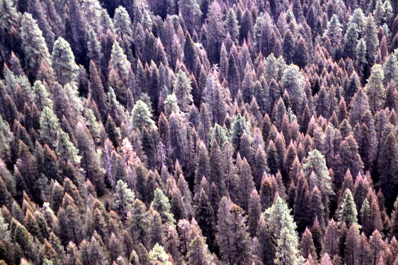
The above photo is from 2007, by R6 State and Private Forestry of western spruce budworm defoliation. It wasn’t identified to location as far as I could see.

This one is on the Deschutes.  For those interested, there is an extensive historical record of photos about various spruce budworm projects here. If you worked on any of those projects you might find a photo of yourself!

******************

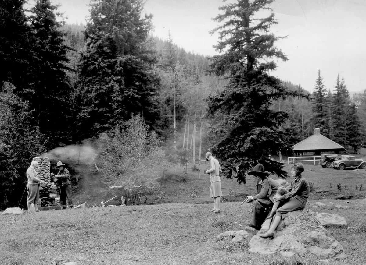
I think we’re having a great discussion about the East-Side screens and the 21- inch diameter rule. Here I’d like to throw in an Old Person observation from my time on the Ochoco during the 80’s.  It’s an Old Person observation about what seems to have changed and what has not changed in 40 years.  I worked for four forests (the Fremont, Winema, Ochoco and Deschutes), but I’ll focus on the Ochoco.

**************

Historical aside: The Ochoco Supervisor’s Office at the time was a large open, cubicle puzzle space.  I sat in the silviculture zone, next to the irrepressible Duane Ecker, the forest silviculturist, Don Wood and our boss, the Timber Staff,  Chuck Downen. But thanks to the wonders of the cubicle environment, I often heard conversations of the Law Enforcement Officer (finding that particularly interesting things were said when he lowered his voice.. “the perpetrator…”).  We all had Data Generals (DG’s). Unfortunately, but sometimes entertainingly, our Public Affairs Officer, Joe Meade (who was visually impaired),  had a DG that read his email out loud .. in a tinny.. monotonous.. slow… voice.  Apparently headphones were too technically or financially difficult to procure.

**********

At the time, people were running Forplan, and somehow we were involved in the tree-growing part.  It could have been John Cissel, our Forplan soothsayer or Bill Anthony, his Deschutes counterpart , who told us “Forplan tells us to cut the ponderosa pine and grow grand fir, because they grow faster and ultimately produce more volume.” Or something like that.  I know there are folks here who know more about what Forplan was supposed to be doing than I do.

So we silviculture folks explained why we thought that that was not a good idea.   White fir/grand fir/ hybrid (WGH) firs aren’t fire resistant.  They have a tendency to get spruce budworm, Doug-fir tussock moth, fir engraver, and a variety of root and other diseases.

So flash forward to today.. now “growing faster” is good idea-wise due to carbon.In this story about a study that Anonymous referred to:

“This is why specifically letting large trees grow larger is so important for climate change because it maintains the carbon stores in the trees and accumulates more carbon out of the atmosphere at a very low cost.”

The study highlights the importance of protecting existing large trees and strengthening the 21-inch rule so that additional carbon is accumulated as 21-30″  trees are allowed to continue to grow to their ecological potential.

As a former silviculture worker, this feels pretty much the same as the Forplan idea of 40 years ago.  Assume- no fires, bugs, diseases, drought (conceivably made worse by climate change) and the firs will do fine by themselves! No openings for establishment of PP or WL necessary.

But silviculturists, forest pathologists and entomologists, and fuels practitioners are dealing with the same biophysical realities-  that trees don’t grow- whether to be cut as in Forplan, or to sequester carbon-  if they’re dead and /or burned. It’s interesting to see that the body of resource professionals’ knowledge  haven’t changed much over time (the interaction of trees, bugs, diseases and fire), while ideas about what practitioners should be doing from Forplan to carbon..seem to come from, and have the imprimatur of, people (however well-meaning) generally from elsewhere; places, apparently where fire, bugs, diseases and drought are not a big thing.

***********************

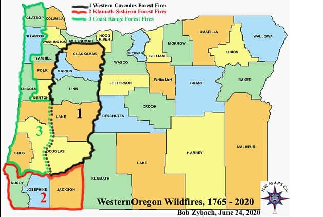
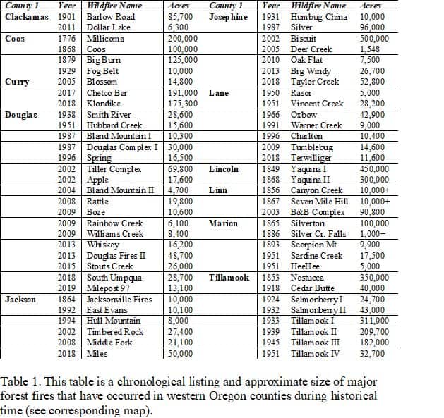
If you want to see how much people already knew in 1994, there’s an excellent round-up, at least as far as the Blue Mountains go, by  by the Malheur Forest Silviculturist, David C. Powell,  in 1994- 30 years ago now.  Same old..

White fir, the favorite food of spruce budworm, has flourished in the fir stands that have encroached on ponderosa pine sites over the last 80 years. By controlling natural underburns, land managers were inadvertently swapping ponderosa pines and western larches for white firs and Douglas-firs. (p. 5)

Ponderosa pine depends on fire to clear away accumulations of needles and twigs so its seeds can find moist mineral soil, and to kill encroaching firs that prevent seedlings from getting
the unobstructed sunlight they need.

By controlling natural underburns, land managers allowed fire-resistant pines and larches to be replaced with shade-tolerant, late-successional species. Many of the replacement species are susceptible to the effects of western spruce budworm, Douglas-fir tussock moth, Indian paint fungus, Armillaria root disease, and other insects and pathogens. (p. 19)

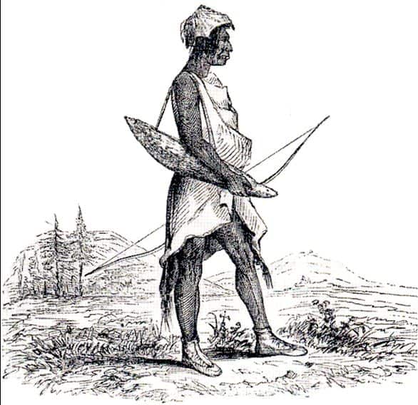
And there’s an interesting section on Native American burning practices:

Although some of the underburns were started by lightning storms in mid or late summer (Plummer 1912), many others were ignited by native Americans (Cooper 1961, Johnston 1970, Robbins and Wolf 1994). When analyzing early journals from the western U.S., Gruell (1985) found that over 40 percent of the fires were described as being started by native Americans.

Two major factors led to conversion of pine stands with underburning to laddered stands with shade-tolerant species.  One was fire suppression:

Many land managers would agree that wildfire suppression was a policy with good intentions, but it was a policy that failed to consider the ecological implications of a major shift in species composition. White firs and Douglas-firs can get established under ponderosa pines in the absence of underburning, but they may not have enough resiliency to make it over the long run, let alone survive the next drought. This means that many of the mixed-conifer stands that have replaced ponderosa pine are destined to become weak, and weak forests are susceptible to insect and disease outbreaks (Hessburg and others 1994).

By controlling natural underburns, land managers allowed fire-resistant pines and larches to be replaced with shade-tolerant, late-successional species. Many of the replacement species are susceptible to the effects of western spruce budworm, Douglas-fir tussock moth, Indian paint fungus, Armillaria root disease, and other insects and pathogens. (p. 19)

The other reason was the attraction of cutting pine and leaving the GWH firs.  Powell provides some detailed explanations of why that seemed like a good idea at the time (mo clearcutting, no expensive tree planting)(p. 27) . And there were interactions between controlling underburns and reducing tree vigor due to competition, so then they would want to take these stressed pines.

Since old pines often have low vigor and little resistance to insect attack, they were harvested before being attacked and killed by western pine beetle or mountain pine beetle. One reason for low vigor in oldgrowth pine trees was competition from a dense understory, an understory that would not have been present if underburning had been allowed to play its natural role.

In 1994 folks were thinking about climate change:

Reestablishing ponderosa pine and western larch on sites that are suitable for their survival and growth, and a thinning or prescribed fire program to keep those stands open and vigorous, would probably do much to address global warming concerns. Using a plan like that one would not only restore much of the pine and larch that was removed by partial cutting (see fig. 21), but it could also create healthy forests with an increased resistance to a variety of insects and pathogens.

And they were also thinking about (healthy=preEuro times) (p. 34)

Perhaps an appropriate yardstick of ecosystem health is natural variation: are the changes caused by budworm consistent with the historical range of variation for similar ecosystems and vegetation conditions? For the mixed conifer forests of the southern Blue Mountains, the answer is probably “no.” It seems that 80 years of fire suppression and 50 years of selective harvesting have resulted in vegetation conditions that differ significantly from those of presettlement times (Table 3).

***********
If some think that the FS wants to cut larger GWH fir unnecessarily, why would they want to do that?

Foster (1907) White fir, though occasionally used for fuel when no better species are available, makes poor fuel wood, while for saw timber it is all but valueless owing to the fact that nearly all mature trees are badly rotted by a prevalent polyporus, and the wood season-checks badly. (p.30)

Forest Service employees have sometimes been called p— firs due to the “badly rotted” characteristics of white fir.

Blast From the Past: Heritage Forest Campaign Yesterday, Climate Forest Campaign Today

One of the points I like to make about our forest policy world is that it is a great space for folks raising families and with other commitments. You can take a few years off (or possibly decades) and come back and not really miss much.  Thanks to the TSW reader who found this hearing from the year 2000.  If you swapped out “Climate Forest Campaign” for “Heritage Forest Campaign” and OG for Roadless, and  Biden for Clinton-Gore, and probably increased the budget figures, it sounds like the same thing, and I think the questions asked are still worth pursuing.  Sorry about the formatting.  This is just Chenoweth-Hage’s introductory statement, I didn’t read the rest, there are 128 pages. Might be other interesting stuff there.

Recently , one of the lead stories in Philanthropy magazine was about foundation funding of environmental organizations . Now , the article said that today foundations have much of the public agenda , and nowhere more so than in the area of environmentalism , where foundations collectively spend upwards of $ 500 million per year that we know of . 

Today we are here to analyze the relationship among large foundations , environmental groups , and the Federal Government in Federal public land management policy , in regards to recreation , timber harvests , mining , and other public lands issues . We will also explore the impacts of these policies on local communities . Environmental groups are relying more and more on a core of wealthy , nonprofit foundations to fund their operations . 

The largest environmental grantmaker  the $ 4.9 billion Pew Charitable Trusts gives more than $ 35 million annually to environmental groups . Other large wealthy foundations such as the Turner Foundation , W. Alton Jones , and Lucile and David Packard Foundations , are not far behind Pew in their grantmaking to environmental groups . 

Foundations have funded environmental advocacy campaigns for more wilderness , curtailing timber harvests , and mining , breaching dams , and Federal control of ecosystem planning . An example of this type of activity is the Heritage Forest Campaign , the subject of an oversight hearing on February 15 , 2000 , by the Subcommittee on Forests and Forest Health .

The Heritage Forest Campaign , a coalition whose sole purpose appears to be lobbying the Clinton- Gore administration to implement the Roadless Initiative , which would withdraw up to 60 million acres of national forest lands from multiple use . This campaign is largely organized and funded by tax free grants from charitable foundations such as the Philadelphia based Pew Charitable Trusts , with $ 4.9 billion in assets the fifth largest U.S. charitable foundation . 

Now , since September 1998 , Pew has given the National Audubon Society more than $ 3.5 million in tax  free grants to organize the Heritage Forest Campaign , a coalition of about a dozen  environmental groups . The sole objective of the campaign appears to be the creation of widespread public support for the Clinton –  Gore administration’s initiative to restrict access on 60 million acres of national forest lands . 

The Heritage Forest Campaign illustrates several potential problems with foundation  financed environmental political advocacy , namely the lack of fair , broad based representation , and the absence of accountability . Particularly disturbing is this administration’s acquiescence to the campaign in the setting of policy . 

At a recent hearing on the Roadless Initiative , I asked George Frampton , Director of the Council on Environmental Quality , for the names of all those attending any meetings he had held regardinging the development of the Roadless Initiative . The list he sent in response is a who is who in the environmental community . Even more telling is that not one individual representing recreation , industry , academia , county commissioners , or local schools were in attendance . Only representatives of the national environmental groups participated . 

Not only was the public excluded during these meetings , but so was Congress . The administration’s Roadless Initiative appears to be an attempt to bypass the role of Congress . Under Article IV , Section 3 , of the United States Constitution , Congress possesses the ultimate power over management and use of lands belonging to the United States . 

If the Roadless Initiative is universally popular , why can’t the Heritage Forest Campaign get it enacted by Congress through the normal legislative process ? Administrative directives , such as the Roadless Initiative , bypass Congress and centralize policymaking authority within the hands of unelected bureaucrats in the execu- tive branch . 

Foundation-funded advocacy groups make backroom deals , thus denying the average citizen a voice and input into the policy through their elected representatives in Congress . As a result , our Government becomes more remote and unresponsive to the needs of the average citizen . 

To whom is the Heritage Forest Campaign accountable? This campaign is put together by foundations, not the participants . The grantees are accountable to the foundations that fund them , not their own members . Foundations have no voters , no customers , and no investors . The people who run big foundations are part of an elite and insulated group . They are typically located hundreds or even thousands of miles from the communities affected by policies they advocate .

They receive little or no feedback from those affected by their decisions , nor are they accountable to anyone for promoting policies which adversely affect the well  being of rural people and local economies . Today’s witnesses will tell us how their communities are being crushed by an inaccessible and faceless movement , wielding great power and influence . 

The role of large foundations in funding environmental advocacy raises some fundamental questions . Foundation wealth shapes public policy at the expense of all counter views . Even worse , those skeptical of foundation  supported policies are often smeared by foundation funded media campaigns in an attempt to marginalize them in the debate . Even alternative environmental solutions are rejected out of hand as environmental groups mold their programs and their agenda to please the large grantmakers . 

Does foundation financed advocacy prevent full and fair public debate on public lands issues ? Is the average citizen’s voice and input in the government decisionmaking process drowned out by foundation  funded advocacy groups ? 

The most fundamental question of all is , what happens to the towns and communities affected by policies resulting from foundation  funded advocacy ? The people living in these communities are left with a ruined local economy . Their towns lack the income to provide even basic services . Their schools have no revenue to teach their children. 

The important issue here is whether the foundation strategies used to fund the environmental movement are buying undue influence for those groups on public lands policy . I believe it will become very clear during this hearing that this isn’t an issue concerning the environment , but rather one concerning power and its use for political ends , with rural communities being trampled in the process.

**********

Now, Rep. Chenoweth-Hage was appropriately concerned for rural communities as she represented Idaho.  At the same time, today, these policies influence all kinds of communities near Federal lands.  Another difference between then and now is our interest in the voices of Tribes, ethnic minorities and the poor and working class- marginalized communities.  How are these folks (say folks from poor rural communities)  represented on Boards and decision-making in these foundations?

“The important issue here is whether the foundation strategies used to fund the environmental movement are buying undue influence for those groups on public lands policy.” IMHO this question is still valid.

Finally, what is the endgame of these foundations, if they have one? Is it the same old “no oil and gas drilling, no mining, no grazing, no commercial logging, no OHV’s”?  I don’t know that we know, nor can I imagine who would have the political power to have that conversation.

Seattle Times Story on Osborne Landscape Forest Photo Comparisons

Many thanks to John for this link to a Seattle Times story on John Marshall, who is taking photographs from the same areas as the Osborne photos of the 1930s.   Very cool photos and it’s not paywalled.  If you want to learn more about the Osborne photos, Bob Zybach provided a link to a project trying to provide comparison photos  over a broad area.  The Osborne photos from some areas you may be familiar with are posted on the site.  This seems like a useful effort, and it sounds like lots of different folks are funding different parts. I’m surprised someone with funds doesn’t take this on more broadly and coordinate.  Here are some quotes from the story:

His images, taken from the same vantage points nearly a century later, illustrate the consequences of relentless fire suppression. Across the state, Marshall has documented the transformation of landscapes historically characterized by patchworks of saplings, mature trees, shrubs and meadows — all shaped by frequent, small fires. Today, clearings have been swallowed up. Habitat diversity has diminished, and ridges and hillsides are thick with timber. Many forests, especially in Central and Eastern Washington, are stressed by overcrowding, heat, drought and insect infestations — and primed for megafires.

It’s not a new story, but the pictures tell it in a way words can’t.

…..

Forest Service ecologist Paul Hessburg, who helped recruit Marshall to the panorama project in 2010, has used the before-and-after images in scores of scientific publications and nearly 200 presentations to peers and the public, making the case for allowing some fires to burn and deliberately setting others to reduce the risk of massive blazes.

“These visuals are so powerful because they show the scale,” says Hessburg, who’s based at the Pacific Northwest Research Station in Wenatchee. “People come up to me after talks and say, ‘You know, I wouldn’t have believed it until I saw it — but there it is.’ ”

The panoramas also helped Hessburg bust a long-standing myth that high-elevation forests in the Northwest hadn’t burned frequently in the past. “John and I have been working together in different geographies to show people how, in 100 years or less, the forest has changed,” he says. “And it’s changed more than we could have even imagined until we had these pictures.”

**********

The agency recently launched a forest health initiative that includes tree-thinning and prescribed burns. “We’ve grown up with these dense, thick forests, so people naturally think that’s what a healthy forest looks like,” says Chuck Hersey, of DNR’s Forest Resilience Division. “But our fundamental forest health problem in Eastern Washington is that there’s too many trees.” Side-by-side images separated by nine decades make the case at a glance, showing the stark changes in the landscape.

One example is Squilchuck State Park near Wenatchee, where fire used to sweep through every dozen years or so before land managers started snuffing out every blaze. A detail shot from the 1934 Osborne panorama shows open meadows interspersed with clumps of mature, fire-resistant Ponderosa pine and sparser stands of firs and other species. In the image Marshall made in 2018, the area is blanketed with wall-to-wall trees. The pictures helped Washington State Parks explain its rationale for two recent thinning operations to lower the fire risk.

*************

In 1934, several patches across the landscape had recently burned, he explains. Some were ringed with shrubs and deciduous trees. Now, most of those areas are completely knitted in with conifers. But in other places, there seem to be more openings in the tree canopy today than 90 years ago.

“That’s due to insects and disease,” Marshall says. While fires clear out flammable material, infestations don’t. “It only adds to the fuel loads, which are just ginormous now.”

We might want to email the reporter and thank her.. “catch people doing something right”.. maybe FS folks remember the training we had on that..

Wisdom of One Elder (or Not): And a Link to My Yale School of the Environment Award Video

Last month, I rode the train into Union Station, New Haven, Connecticut for the first time in fifty years.  That was 1972, two years after Earth Day, three years after NEPA, and NFMA was not yet a twinkle in the eye of Congress.  So let’s just say that much has changed since then.  Fifty  years  before I took the train in 1972 was 1922, right after World War I and before the Dust Bowl, which remains the US’s worst environmental disaster.  And fifty years from now will be 2072, which seems like a long ways away. If you think about a fifty-year span of time, you may be able to see patterns- what is a trend and what is a blip

I was in New Haven to receive an award from the Yale School of the Environment Alumni Association.  As I told the students, if you work on the same thing for 50 years, chances are, somewhere along the way, someone will appreciate it (even if you have to wait a long time :)) .  I was hoping to give a seminar (challenging the Coastal Elite in the hold of their Mothership, what fun!) but post-Covid they decided to move to video.  This was a bit challenging for me, as they were looking for video of me doing interesting things, but I was lucky to find black and white photos. Most of my work has been not visually interesting, think Data General or later terminals, or rooms with people and flipcharts- or even piles of paper, or conference calls (pre-Zoom). I spent weeks digging through old files, remembering people, and thinking about my story and all the different ways of telling it. I am very grateful to the talented editor and producer Alana DeJoseph for spinning gold from a mess of straw.

I would never have dug into all this without the prompt from Yale, but it has been a meaningful exercise for me.  I reached out in gratitude with many colleagues from the past. And it was interesting to find what bits of history are available on the internet and which are not. The human brain is all about story-telling and sense-making, and what could be more human than telling your own story?

So I’m making a request, for any of you who are so inclined, I’d be interested in posting reflective historic pieces; what did you experience? what did you learn? what is your current perspective on your experiences? what advice would you give to younger folks?

Here is a link to award write-up and the video. 

Historic Sites Raise Concerns About Siting of Renewable Energy Infrasturcture

The view east from the Sand Creek Massacre National Historic Site. Park advocates and members of the Cheyenne and Arapaho tribes, whose descendants were victims of the 1864 massacre, are concerned that a massive Xcel Energy project could infringe on the “cultural landscape” by placing towers and transmission lines in the viewshed. (Provided by Matt LeBlanc to the Colorado Sun)

The Colorado Sun has a story about wind turbine and power line development near historic sites, including Sand Creek, Camp Amache, and the Minidoka National Historic Site.

This article from Boise State Public Radio is about the Lava Ridge Energy Project which is on BLM land near the Minidoka National Historic Site. Conceivably different DOI agencies should be able to work this out.

This quote is about the Sand Creek Massacre site:

“It isn’t like any other national historic site, probably anywhere, because of the atrocities that went on there,” he said. “So when we as the tribes go back to the site, we’re going back to a place of sorrow, because that time era, and the massacre itself, was basically the beginning of historical trauma for our tribal people.

“When we go back to that site to reflect, to commemorate, to mourn, to try to heal,” he added, “seeing some big power lines there doesn’t help with that, aesthetically.”

The debate over how close is too close reflects a burgeoning issue nationwide as proposed construction of large-scale renewable energy projects like wind and solar arrays, key tools in the fight against climate change, bump sometimes uncomfortably against cultural landmarks.

……

And while she acknowledges that the NPS has no control over what happens beyond its borders, she notes that ever since Congress authorized the area as a national historic site in 2000, nothing has interfered with the cultural and educational experience.

“There were periods when it looked like oil and gas development was imminent, and large scale agriculture could make an impact on the viewshed,” Roberts said. “But none of that has happened in all these years.”

The National Parks Conservation Association, a nonprofit that describes its mission as protecting and preserving the nation’s parks, two weeks ago submitted a letter to the Colorado PUC, as well as Xcel’s siting consultant, laying out its concerns about the viewshed and communication with tribal interests. In addition to the Xcel project, the NPCA also is sensitive to potential wind power construction of towering turbines that rise higher than transmission towers, wrote NPCA Colorado senior program director Tracy Coppola.

Some park advocates recommend that transmission line towers — Xcel estimates the single-pole structures rising from 105 to 140 feet, depending on topography — should be at least 12 miles from its boundaries. In calculating that distance, the Sand Creek Massacre Foundation referenced a 2013 National Park Service-commissioned natural resource assessment, then adapted that report’s findings with regard to the viewshed to take into account the height of the towers.

Currently, Xcel said, it is evaluating locations for the new transmission lines 4 to 8 miles from the site’s boundary, but also will consider other options. “And that’s all part of our analysis,” said project manager Heather Brickey. “Our goal is to find the best route that meets the needs of the project and also meets the needs of the community.”

The NPS assessment identifies the cultural landscapes and viewshed as “fundamental resources and values for the site.”

“From a cultural and historical perspective, the views are not just about the scenery, but rather an important way to better understand the massacre at Sand Creek Massacre NHS,” the report said. “Visualizing the massacre as it played out on the landscape is a critical part of the visitor experience.”

Memories from the 10th Mountain Division (Camp Hale, Colorado)


Image courtesy of Laurie Gwen Shapiro by way of The Forward.
Top of the World: Morrison circa 1943. He received a Bronze Star for his service in World War II.

I’ve visited Camp Hale on field trips with the Forest Service.  Right now, I believe something about preserving/interpreting Camp Hale is in the CORE Act. I ran across this piece this morning telling the history of one soldier in the 10th Mountain Division,  Sam Meiselman (Morrison), in the Forward.

I first went back with other veterans in 1988 to the battlefields, and that helped bring inner peace, too. I’ve gone many times since, but that first trip brought back memories, good and scary. To this day there are foxholes covered over by grass; you have to be careful. I took 35 rolls of film, many pictures of the villagers who remembered us. So many of those people are dead now.

We fellows closed up the war. The 10th is a great outfit, and we showed the way. Bob Dole, and all the rest of us, we didn’t want this country to get caught short again without special forces. And because of what the Germans had mountainwise, we smartened up America.

I enjoyed reliving the past, but I looked to the future. I was not just active in the 10th Mountain. I’ve also been connected to the International Federation of Mountain Soldiers, where people in mountain divisions of all countries reunite. We remember those lost, and we tell our stories and the stories of those who did not make it back. We have our own pin, and we’ve created peace trails. Ours is in Colorado. I’ve walked that with former Nazis. A German soldier is a member — we are all close-knit brothers now for the love of the mountains — and the love of peace. I know we were called the “Greatest Generation,” but I am well aware we are among the disappearing generation. The old story is, it takes three to take a mountain: one to get killed, one to get wounded and one to tell the story. I got two out of three. So I didn’t do bad.

The whole story is interesting and I believe the Forward allows a number of free articles.


100 Years Ago- Health Camps for the Spanish Flu.. Arthur Carhart and the History of National Forest Camping

Campers in what was the Davenport group in the mountains west of Pueblo (CO). The FS’s Davenport Campground remains west of what was considered the Agency’s first camp, envisioned between 1919 and 1920. Photo courtesy of the Forest Service.

Here’s an interview with Ralph Swain, long-term Forest Service regional recreation specialist in the Colorado Springs Gazette.

And Swain can’t help but laugh now. Because of how obvious the answer became, yes. But also because he now knows there was a lesson from 100 years ago.

In 1920, Coloradans were still dying, though less frequently, from the flu that had taken the country by storm two years prior. Also in 1920, there was a young man by the name of Arthur Carhart who was in the final stages of developing a recreation site intended to meet the demands of new outdoor masses.

In the San Isabel National Forest west of Pueblo, there was to be a “health” camp, as Carhart tended to call it.

It would become an inspiration for Forest Service campgrounds everywhere.

This has been a recent point of research for Swain, a passionate, amateur historian. Carhart “would’ve anticipated it,” Swain says of today’s crowding in the woods. “He would’ve said, ‘Oh yeah, they’re gonna come, and they’re gonna come in droves.’”

As they had been from Pueblo during World War I, escaping the heat and troubles of civilization for the cool, refreshing wilds of the Wet Mountains.

It was a troubling time indeed. In 1914, before men left for the conflict in Europe, before they contracted the fast-spreading sickness in the trenches, they were reeling from labor wars close to home. Miners, women and children died in the Ludlow Massacre, the fallout of which reached a short distance north to John D. Rockefeller’s steel empire in Pueblo.

“As a result,” reads a paper prepared by and for the Forest Service, “the local community sought increased and safe access to the newly discovered benefits of hunting, fishing, and family gatherings on public lands.”

This, researchers have noted, was all part of demands for more leisure and higher pay and the kinds of safer, 40-hour workweeks that were being negotiated in cities nationwide, not just in Colorado’s second-largest metro, as Pueblo was then.

..

The Squirrel Creek concept included brief pull-offs for cars to reach “private” sites, along with picnic tables, water pumps, trash receptacles, fire grates and latrines.

“This new idea called ‘camping’ took off,” the Forest Service later recounted.

Squirrel Creek Canyon was added to the National Register of Historic Places in 2005. Though much was destroyed in a 1947 flood, remains of the old campground can still be found along the Squirrel Creek Canyon Trail, west of Pueblo Mountain Park and east of Davenport Campground. The canyon is about 5 miles north of Lake Isabel, the destination that Carhart also envisioned.

Largely lost around that old campground is a trail from Carhart’s day. Wingate hopes to revive it in the next couple of years, pending funds. “As a remembrance of what it was like,” he says.

Bob Zybach on Western Oregon Fire History

Map 1. This map shows the specific counties in western Oregon in which major forest fires have occurred during historical time. The three subregions of primary concern are the western Cascades; the western slope of the Coast Range; and the Klamath-Siskiyou Mountains (see table).

Fig. 2. Kalapuyan man and eastern Coast Range foothills drawn in 1841 by Alfred Agate, a member of the Wilkes Expedition, near present-day Monroe, in Benton County. Regular landscape-scale fires set by Kalapuyan families and hundreds of generations of their ancestors on the land resulted in open grasslands and oak savannah – rather than forests — throughout most of the Willamette Valley and eastern Coast Range.

Many veterans of The Smokey Wire (or its predecessor, NCFP) may remember (Dr.)Bob Zybach, who was our resident expert on fire history in western Oregon (he wrote a book on it, and his doctoral dissertation).

He is knowledgeable about the time period when early non-Native settlers encountered Native American burning patterns and then recorded history. Since the 1850’s were only 170 or so years ago, and trees live (sometimes much) longer than that, what we see on the land today is still influenced by Native burning patterns as well as the transition, as well as activities of the 20th and 21st centuries.

I reached out and asked him for his historical views on the West Side fires. He sent me thisarticle he wrote for the Oregon Wildlife Journal. It’s too long to be a post, but take a look. Here are a couple of interesting things:

First, he broke the discussion down by county, including eastern Coast Range, western Coast Range, western Cascades and so on (see map above).
Second, he point out a couple of cases of reburning, including the Tillamook Fires and fires in the Kamiopsis Wilderness. Fires lead to dead dried out vegetation, which leads to more fires (I guess?). The figure above is a map of some fires in the Kalmiopsis.

Here’s his own summary:

The general information provided by the timing, extent, and location of these major wildfires should be of interest to western Oregon resource managers and US taxpayers — and to their elected representatives. Here are some basic conclusions that can be drawn from these events:

1) Each county has its own unique history of large-scale wildfires, with significant differences between them: e.g., Benton County has never experienced a large-scale forest fire; Tillamook County has had numerous such fires from 1853 until 1951, and little or nothing to the present time; while Douglas County had few major fires until 1987, and have seemingly had them on an almost annual basis ever since.

2) There were hardly any major wildfires in western Oregon between 1952 and 1987; a 35-year period in which these forests were the most actively and intensively managed in their history.

3) Almost all major wildfires during the subsequent 33 years, from 1987 to 2019, have occurred on federal lands – rather than private, county, or state — and were mostly ignited by lightning or arsonists.

Empathizing With Everyone: Patty Limerick and Violence in Western History

A Kiowa ledger drawing possibly depicting the Buffalo Wallow battle in 1874, one of several clashes between Southern Plains Indians and the U.S. Army during the Red River War. Image from TARL Collections (TMM-1988-21 Reverse).


Folktales will return next week.  The recent discussion about Oregon counties reminded me that we can feel compassion for everyone.  There’s no need to ration compassion, as the human heart can be infinitely elastic. In Patty Limerick’s words:

Refusing restraint, empathy defied and transgressed the most clearly marked lines of antagonism and opposition,

So I thought I’d post this piece by University of Colorado history professor Patty Limerick that talks about her journey toward CTA (compassion or empathy toward all) in terms of Western American history.  Which is not unrelated to #EnvironmentWithoutEnemies.  Somehow many environmental (including forest) issues have folks involved who tend to see “good guys” and “bad guys’.  Or black-and-white issues (e.g., salvage logging must always be bad).  Or perhaps they don’t really think that way, but choose to communicate in those ways because they think good guy-bad guy narratives get more clicks, or portraying something as black-and-white is more persuasive.  Hard to tell. There are also many people who don’t see the world this way, but perhaps it is more difficult to find them on social media.

Anyway, Here’s the link to Patty’s entire piece and an excerpt below.

In the early 1990s, I called a halt to this awkward effort at self-protection and wrote an essay called “Haunted America” on violent conflicts between whites and Indians. This essay appeared in a book of photographs taken at places where calamities and tragedies had occurred. With rare exceptions, most of these sites had become places of forgetfulness, without any visible indication of the brutal events of the past.

For three months, I read nothing but stories of violent encounters between Indian people and Euro-American soldiers and settlers. When I woke in the middle of the night and when I got up in the morning, my mind found no refuge from bullets, knives, arrows, sabers, ropes for hanging, and torches for burning.

Soon, there was nothing left of the emotional distance I had tried to keep between me and the violence of the Western past.

There is no question of who provoked these wars and who invaded whom. Euro-American people were the invaders, and Indian people were the inhabitants of the lands the invaders wanted.

And yet, immersed in wrenching stories of violence, I lost the ability to choose sides.

I empathized with Indian people, who had been besieged, pursued, and attacked in episodes beyond counting.

I empathized with settlers, who were often genuinely oblivious to their status as disruptive invaders, but who became, for reasons that would be hard to miss, targets of attack.

When people suffered devastating attacks on their homes, I responded with equal anguish to the miseries inflicted on families of Indian people, families of white people, and, maybe most vulnerable of all, families of people of mixed heritage.

Refusing restraint, empathy defied and transgressed the most clearly marked lines of antagonism and opposition, and I found myself unable to discount the ordeals of the soldiers who had been placed squarely in the middle of situations where resentment, retaliation, and rage ruled.

Many of these soldiers were immigrants who arrived in the United States with little money and who saw signing up as soldiers as one of their few routes to opportunity. Others were African American men who were emancipated slaves, or refugees from the injustices of Southern tenant farming and sharecropping. Meanwhile, even if Army officers may have come from origins in what we would now call “white privilege,” there was nothing that could pass for comfort or ease in the life of soldiers from the white working class.

Indisputably an army of invasion, this was also an army of unreliable equipment and inadequate clothing, especially in seasons of heat and cold; meager and often inedible rations; and constant risk of accidents, exposure, illness, exhaustion, and injury and death in battle. Perhaps most important, the soldiers faced these risks because they were following the orders and executing the policies decreed by distant presidents, senators, congressmen, and appointed officials who had only a sketchy knowledge of the conditions in the West.

Yes, these soldiers participated in devastating military campaigns against Indian people. But nothing in their stories could convince me to lead the campaign for their demonization.

By the time I sat down to write the essay, I had empathized with nearly everyone. But a few individuals, who had moved through life with a savage and intentional cruelty, gave empathy a chance to take a break. In truth, it was a relief to come upon dreadful people who I could simply find contemptible.

I’m not sure that we have any of those in our (forest) world.

Tie-Hacking in the Sierra Madre: Investigations of a Historic Logging Landscape

This post is a shout-out to sometimes under-appreciated Forest Service folks and contractors- the archaeologists.  Also please consider volunteering for the Passport in Time program. The website has a list of ongoing and completed project by Forest.

Broadly speaking, we can’t understand forest structure today without understanding the past. And history almost always involves people- Native and Imported Americans (historically, they weren’t all Euro and not all “white”).  So here we are today, and sometimes we can’t see the imprints of our predecessors simply by driving by or walking through the landscape. That’s why we need the help of historians and archaeologists. On that note, I’d be interested in posting other historic studies of current National Forest land.

We can read the words of people in the past, though, as with Leiberg’s observations around 1900, and archaeologists examine artifacts and can tell us more. Keep in mind that for example, the Medicine Bow forest was initiated in 1902 (at least according to Wikipedia) so these activities were all pre-National Forest designation.

It wasn’t until I attended a presentation by Dave McKee of the Bighorn National Forest that I realized the extent that the Sierra Madre had been modified into a populated landscape to provide tie hacks to the railroad.  Looking at the size of the streams, it’s hard to imagine logs going down them.  Yet at one time, the railroad was the main conduit for travel and transport in the Interior West,  and streams were the mode of transporting logs, even in this fairly dry country.  Here’s a paragraph from Dave’s paper Tie Hacks 2009   in the Wyoming Archaeologist.

Intensive mapping and site recording procedures were used to describe a set of historic logging camps along the East Fork Encampment River drainage on the Medicine Bow National Forest. Logging camps associated with Carbon Timber Company’s operations can be categorized into two basic sites types including communal and satellite camps. A trail system linking these sites together provides the framework for the historic landscape. Communal camps may have served as distribution centers for critical resources such as horse teams and supplies. An analysis of artifacts suggests the presence of women and/or children in a number of camps. Preliminary spatial analyses suggest communal camps were centrally located within a group of satellite camps to maximize resource distribution and enhance efficiency of logging operations within the larger East Fork drainage. The data provide a picture of an organized resource extraction industry located in a rugged and rural environmental setting.

After I heard Dave McKee’s excellent presentation at a Rocky Mountaineers (FS retiree) meeting, I looked around and found that tie hacking has a history in many places with railroads. It might even be something that occurred on your neighboring forests.

Tie Hacks 2018 Oct 30 2019 is a copy of Dave’s powerpoint. Great photos, I have just pulled out a few for this post. I’m hoping that someday Dave will video his presentation and we can share that!