Many veterans of The Smokey Wire (or its predecessor, NCFP) may remember (Dr.)Bob Zybach, who was our resident expert on fire history in western Oregon (he wrote a book on it, and his doctoral dissertation).
He is knowledgeable about the time period when early non-Native settlers encountered Native American burning patterns and then recorded history. Since the 1850’s were only 170 or so years ago, and trees live (sometimes much) longer than that, what we see on the land today is still influenced by Native burning patterns as well as the transition, as well as activities of the 20th and 21st centuries.
I reached out and asked him for his historical views on the West Side fires. He sent me thisarticle he wrote for the Oregon Wildlife Journal. It’s too long to be a post, but take a look. Here are a couple of interesting things:
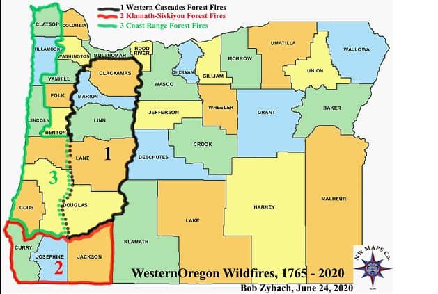
First, he broke the discussion down by county, including eastern Coast Range, western Coast Range, western Cascades and so on (see map above).
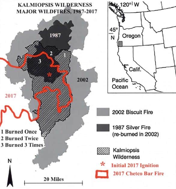
Second, he point out a couple of cases of reburning, including the Tillamook Fires and fires in the Kamiopsis Wilderness. Fires lead to dead dried out vegetation, which leads to more fires (I guess?). The figure above is a map of some fires in the Kalmiopsis.
Here’s his own summary:
The general information provided by the timing, extent, and location of these major wildfires should be of interest to western Oregon resource managers and US taxpayers — and to their elected representatives. Here are some basic conclusions that can be drawn from these events:
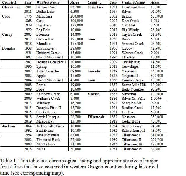
1) Each county has its own unique history of large-scale wildfires, with significant differences between them: e.g., Benton County has never experienced a large-scale forest fire; Tillamook County has had numerous such fires from 1853 until 1951, and little or nothing to the present time; while Douglas County had few major fires until 1987, and have seemingly had them on an almost annual basis ever since.
2) There were hardly any major wildfires in western Oregon between 1952 and 1987; a 35-year period in which these forests were the most actively and intensively managed in their history.
3) Almost all major wildfires during the subsequent 33 years, from 1987 to 2019, have occurred on federal lands – rather than private, county, or state — and were mostly ignited by lightning or arsonists.
I was on a video of the Annual Conference with the Society of Environmental Journalists, and Seth Borenstein of the AP (in the context of teaching journalists how to cover fire) claimed that “all fire acreage data before 1980 is c#$p.”
Just another observation of how deciding which different temporal and spatial scales are reported, and which measurements we value versus which ones we dismiss, and which ones we trust others’ corrections for, are all value judgments.
Hi Sharon: I would argue that many of the acreages reported in the 1930s for the Tillamook Fires were pretty good — and the same for most other fires on state, federal, and industrial lands from that time forward. Aerial photos, precise mapping, and taxes all made those numbers important to people.
That being said, most of the acreages given in the table are simply rough estimates or placeholders waiting for better information — I even ask for help refining them in the body of the text.
Even today, most acreage figures given to demonstrate the size of a fire are misleading. Given today’s technology and the propensity for foresters to spend more time at their computer than in the forest, these numbers could be vastly improved at relatively little cost, and provide far better information for forest managers, students, and taxpayers in the future.
For research purposes I put wildfires into four basic categories: grassland, shrubland, forestland, and urban. Urban fires I classify as those within city limits or tax lots less than 20 acres in size. I know very little about these fires, but I do know that grasslands (including pastures) and shrublands (including orchards) are often rejuvenated by fire and the nutrients and limited competition it leaves behind, and that they are a lot safer, cheaper, and less polluting to burn on purpose than in a wildfire.
Forest fires — which have been a focus of much of my research and working environment for more than 50 years — I further divide into three more categories, by fuels: ground, ladder, and crown. Ground fires — found more commonly in pine than Douglas fir, as two examples — are much like grass or shrub fires, in that they often rejuvenate the remaining stand of trees. A beneficial process that is also much better when completed under prescribed circumstances, and for the same reasons.
Ladder fuels are the lower limbs, intermediate-sized trees, and dead wood that carry the flames of a ground fire into the crown of a tree. Crown fires are the main cause of death of trees during wildfires. These snags are of most concern to forest managers, or should be. They are ugly and dangerous, likely fuel for future fires if left to remain, and can often be marketed profitably if sold and salvaged within a short time of being killed. In Douglas fir, a crown fire can readily kill 90% or more of a contiguous stand of trees. It is about the same for lodgepole pine, but often 50% or less for Ponderosa pine. When only 10% of a stand is killed by ground fire-girdling or crown fire, then once again the effects on the remaining stand are likely more beneficial than negative.
So, if we made maps that showed accurate acreages and locations of the various types of fuels consumed in a wildfire, and subdivided the forested areas into mortality rates (e.g., increments of 10%), we would have developed information of very useful value for those charged with managing a forest, and for those charged for paying them to do so. Standard map overlays of ownerships, volumes, species, ages, roads, etc., can then be used more efficiently, and acreage descriptions of wildfires would be a lot more accurate and valuable. In my opinion.