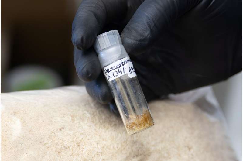
Scientists at the University of Wisconsin–Madison have developed a cost-effective and environmentally sustainable way to make a popular pain reliever and other valuable products from plants instead of petroleum.
Building on a previously patented method for producing paracetamol—the active ingredient in Tylenol—the discovery promises a greener path to one of the world’s most widely used medicines and other chemicals. More importantly, it could provide new revenue streams to make cellulosic biofuels—derived from non-food plant fibers—cost competitive with fossil fuels, the primary driver of climate change.
Paracetamol, also known as acetaminophen, is one of the most widely used pharmaceuticals, with a global market value of about $130 million a year. Since it was introduced in the early 1900s, the drug has traditionally been made from derivatives of coal tar or petroleum.
In 2019, Karlen and UW–Madison biochemistry professor John Ralph showed how it could be made instead from a compound in poplar trees using a well-known chemical reaction.
Now Karlen’s team has improved the process for making paracetamol as well as other drugs, pigments, textiles, and biodegradable plastics with a cumulative market value of more than $1.5 billion, a portfolio of products that Karlen says could support dozens of small biorefineries feeding into larger hubs without saturating the market.
*************
The process is available for commercial licensing through the Wisconsin Alumni Research Foundation, the nonprofit organization that commercializes university discoveries to support ongoing research.
The paracetamol molecule is made of a six-carbon benzene ring with two chemical groups attached. Poplar trees produce a similar compound called p-hydroxybenzoate (pHB) in lignin, the part of the cell wall that binds plant sugars together and provides structure.
Lignin is chock full of valuable aromatic compounds that could replace many petrochemicals and provide biorefineries with additional revenue streams to make plant-based fuels cost-competitive. The challenge is breaking down the complex and irregular chain of molecules into useful components.
We have discussed “corner crossings” and other barriers to public land access resulting from land ownership patterns. Overlaying this is another barrier – availability of information about the extent of public access that does exist. It turns out there is a lot more existing public access than meets the eye, and some technology and legislation is making more information about it available to public land users.
… the Theodore Roosevelt Conservation Partnership teamed up with onX to quantify the scope of the landlocked public lands problem and offer solutions that would open access to these acres. Since 2018, the team has found a staggering 16.43 million acres of inaccessible public land across 22 states. … With $27 million from the Land and Water Conservation Fund dedicated to increasing public land access each year, there is an incredible opportunity to address the landlocked public lands problem through strategic land acquisitions and access easements.
We soon learned that the Bureau of Land Management and U.S. Forest Service held roughly 90,000 such access easements—where permanent access to public land has already been secured—but 50,000 were only recorded on paper, stored away in the dusty filing cabinets of local agency offices. Neither the agencies, nor the public, have ever had a complete digital picture of where there is legal access to our public land. Seeing a clear need for a solution, TRCP experts began talking with lawmakers, which led to introduction of federal legislation called the Modernizing Access to Our Public Land Act.
The MAPLand Act requires federal land management agencies to digitize their paper easements, information about roads and trails and vehicle type on federal land, and the boundaries of areas with federal rules concerning weapon type and shooting. The ultimate goal is to make all of this information readily available to the public. In April 2022, the MAPLand Act was signed into law. This means that complete and consistent mapping data about road, trail, and shooting access will be digitally available to hunters and anglers wanting to use their public lands.
Of course funding this in a deficit-reducing environment may not happen as fast as we’d like.
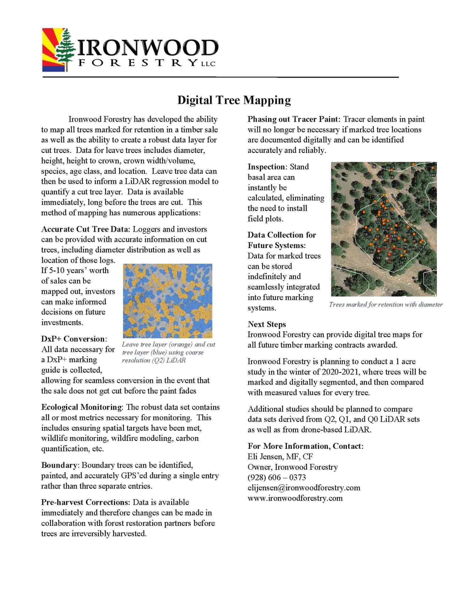
Note from Sharon.. Based on the earlier discussion Jon started here of DxP, I asked Eli Jensen of Ironwood Forestry to add his two cents and also talk about some of his cool technologies. I wanted the technologies highlighted, so am putting this up as a guest post.
On DxP
Great discussion so far. I own one of the contract marking crews in N-AZ. Inexperienced crew technicians marking trees definitely is a problem, on both contract crews and district crews. It boggles my mind that TSP technicians are not given even one day of operations training. We go out with the loggers any chance we get.. And yes, tracer paint is very expensive, and is perishable, meaning the sale is only really good for 5-7 years. That makes it problematic to prep the massive acres needed for industry. If something goes awry (again), the cost to remark is the same as the initial remark.
That being said, I am an open critic of DxP. I won’t say that it’s never appropriate, but it is not the magic bullet for forest restoration. There are some key shortcomings.
1) As alluded to above, it shifts the cost from sale prep to sale admin. I don’t know the numbers on the district side, but for the rates I charge for daily harvest inspection and the frequency the USFS wants me out there, I think it would math out the same to just mark it.
2) Uncertainty. This is the biggest shortcoming in my opinion. You don’t know the outcome. Sometimes it’s great, sometimes its not. If its not, there’s nothing you can do. To me, the cost savings to not mark a sale pales in comparison to botching a sale. It feels too much like gambling, except we’re gambling with something that belongs to the public, not us.
3) Accountability. The USFS can claim all day long that the contracts have teeth. The truth as I know it, aside from basal area and eyeballing the spacing, the USFS has almost no way to tell the logger they messed up. The logger can take all the nice trees and leave all the crap, and there won’t be any way of knowing. The evidence is gone. The USFS barely knows whats out there when it’s marked. They don’t map the mark in any way. No drones. No mobile LiDAR. Low frequency point sampling to inspect the contractor and low frequency cruise plots and that’s it.
4) Tree quality. And how do you determine what’s “crap”? When I’m marking, I spend A LOT of time looking at tree tops. I train my crew to incorporate win/win scenarios in their decision making. If there’s a crooked tree with a vigorous top and a straight tree with a trash top, we leave the healthy top and give the logger the straight log. I’ve talked to a lot of loggers and they all do their best. There’s not a single one that I think poorly of. However, the idea that they’re going to have the same awareness as someone on foot, while also paying attention to cutting, and trying to be productive while burning fuel, and with an obstructed view? That would take some convincing.
5) Conflict of interest. I get a lot of flack for this, but the USFS needs to face this one head on. Anytime you mention this in a meeting, they change the subject or brush it off. Having a financial interest in which trees are being cut, and being able to decide which trees are cut IS A FINANCIAL CONFLICT OF INTEREST. I am NOT saying the logger will high grade it. I am NOT saying the logger will try and pull a fast one. I am NOT saying the outcome will be poor. That’s not what that means. And it doesn’t matter if the trees are high value or low value. It simple means a conflict of interest exists, and its a BIG liability to ignore that. My main concern is one day some environmental group will cause up some ruckus about something or another, as they do, on a DxP sale. Look at the Jacob Ryan sale on the North Kaibab. A pretty decent sized controversy on the regional scale. CBD was upset too many big trees were being cut. Luckily it was a marked sale so the USFS ultimately was responsible. If it had been DxP, the logger could easily have been blamed, and who knows how widespread that smear campaign could be. If I were a logger, I wouldn’t want the liability.
For these reasons and others, DxP has fallen out of favor with some districts in N-AZ. We’re actually submitting a bid on Monday to mark DxP stands in a sale we remarked last year, before they re-offer.
**********************************************
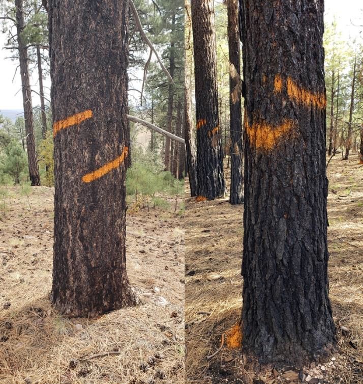
Leave Tree Mark using Ironwood’s System (left) and from a competitor using a Panama system (right)
New Technologies for Better Quality Marking at Lower Cost
This sets me up for what I really came here to share with you all. I have been working very hard for a very long time to present alternative options to the USFS and stakeholders. In the last 3 seasons, we have saved the USFS almost a HALF A MILLION DOLLARS on paint. I developed and built my own paint sprayer that saves 75% on paint, and it looks way nicer too. That’s about $30+ an acre. I have presented this to every level of the forest service, from district to the national modernization board. I have not found anyone that cares about saving money on paint, even though it would be just about enough to fund all of the road packages that everyone was so concerned about.
Furthermore, I’ve been introducing increasingly advanced digital tools. In 2020, we started GPSing every tree we marked, with DBH, at no extra cost. That means we can map the planned post harvest stand and know the basal area to the foot. Then I linked it with aerial LiDAR, so you can see a canopy cover map of the planned future stand. Last year, I upgraded that to mobile LiDAR, giving you a high resolution 3D map of the post harvest stand, with census level data (dbh, height, crown height, width, volume) on ALL leave and cut trees. We can turn +-40% cruise data to nearly 100% accurate. We plan to throw a camera module on the scanner to colorize the point cloud for increased realism. It will look like a 3D photograph because it literally IS a 3D photograph.
The neat thing is, the paint savings is less than the cost of the additional remote sensing. It sounds too good to be true, but its not, its just been a lot of hard work and risk taking.
We finally have a project planned for this summer to deliver all of this on a 3500 acre pilot sale. In addition to the above mentioned, we’re testing out a new marking designation, which we are calling Hybrid Flex (HF). It basically a combination of CTM and DxP+ (tablet marking). We expect additional paint savings, now approaching ~93% (97% if we can use commercial paint), significantly increased technician productivity (shooting for 100 acres/day per person), and it comes with all the digital mapping.
We cannot meet the needs of 4FRI with the old methods, but we can with the new. I’m starting to sound like Billy Mays, but there’s more! We’re working towards abandoning paint all together. Augmented reality individual tree marking. No paint. Doesn’t fade. Census level data. 3D photographs of current and FUTURE stands. We could have introduced this over a year ago if we had the buy-in. We’ve got two partners that can do it – one that will do it for free if the USFS will buy the end result, and another that will develop it for a fee and the USFS owns it. Either way, the development would pay for itself in less than a year from the paint savings, just from AZ timber sales.
If you’ve gotten this far, I appreciate your patience in reading all of that. We’re a small company and we’re looking to serve the needs of the USFS and forest restoration in the southwest, but its been phenomenally difficult despite the technical successes we’ve had.
Here is a link to a video we produced after our Dec 2021 demo.
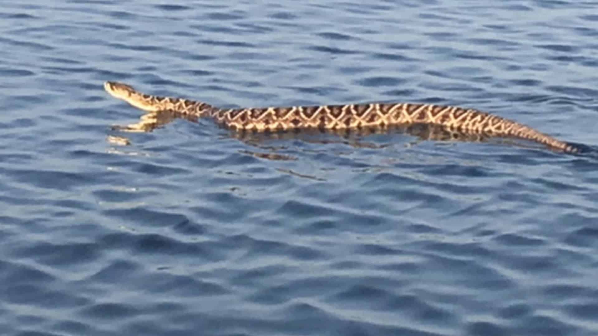
It’s summertime.. Time to watch out for rattlesnakes in reservoirs! Thanks to the Cowboy State Daily. (I forgot to put the link previously so here it is.)
“They actually cross Boysen all the time. I’ve seen it probably 20 times at least on Boysen, I’ve seen it on the Seminoe Reservoir down by Sinclair, the Glendo Reservoir… Flaming Gorge,” he said. “They’re not afraid to get in the water.”
About 20 years ago, a rattler tried slithering into the boat while Edwards and his dad fished.
*************
“It’s the ones you can’t see that you’ve got to worry about,” he said, adding that many people have approached him since he made the viral post, and have told him they paddleboard and play in the lake water.
Edwards tells those people to pay close attention to what’s in the water, watch for graceful serpentine movement. And paddle away.
“I always worry about people who are waterskiing,” Edwards said. “You can run over a rattlesnake.”
Since this is a roundup, feel free to add your own news items of interest in the comments.
(1) * My favorite podcast of the week.
Tisha Schuller interviewing Toby Rice on Energy Thinks. He thinks a great and doable transitional global decarbonization strategy would be to substitute LNG for coal, wood and other more CO2 and particulate producing energy sources to help countries both move off coal and escape energy poverty.
Caution: Rice talks very fast.
Virtual fencing, a relatively new technology, allows ranchers to control livestock distribution in rangeland landscapes without physical fences. Livestock wear collars that communicate with GPS and reception towers to form a virtual fence set by the rancher or land manager. When the livestock reach the limit of the virtual fence, auditory stimuli (often a series of loud beeps) emit from the collar. If livestock pass the fence limit, they receive a benign shock. Cattle have demonstrated the ability and tendency to rapidly learn the virtual fencing cues, eventually responding to the audio cue alone. Several studies have documented success with sheep and goats as well.
Virtual fencing could prove to be an effective climate adaptation strategy, as it can be used to contain animals within a desired area, exclude them from undesired areas, or move them across the landscape. Virtual fencing has the potential to diminish soil erosion associated with overgrazing and to improve soil and water quality through managed grazing. Managed grazing is careful management of livestock density and the timing and intensity of grazing. It can stimulate plant regrowth and add manure to the soil. While ranchers with traditional fences can also practice managed grazing, it requires much more planning and labor, and animal movements are limited to pastures defined by permanent fence boundaries. Virtual fencing allows managers to frequently and efficiently move livestock from one pasture to the next and to define new within-pasture boundaries.
(3) Artificial lights are bad for wildlife-see this Popular Science article. You may wonder, what about lights on wind turbines (so-called “aviation obstruction lighting”)? Well it turns out that in fact people have studied that for birds. Here’s a summary from Nature Scotland.
Since I live fairly close to a windfarm, I thought this was an interesting technological solution.
An alternative approach is to only switch lighting on when aircraft are near. There are a number of systems that react when aircraft approach an operational turbine. For example, the Obstacle Collision Avoidance System (OCAS) is designed to alert pilots if their aircraft is in immediate danger of flying into an obstacle. OCAS uses a low power ground based radar to provide detection and tracking of an aircraft’s proximity to an obstacle such as a power line crossing, telecom tower or wind turbines. This capability allows the visual warning lights to remain passive until an aircraft is detected and known to be tracking on an unsafe heading. This leaves the night-time sky free of unnecessary light thus decreasing public annoyance issues, and limiting situations where bird-strike may occur.
(7) And this AP story on how wildfire risk is being used to stop housing development in California.
That’s not the only time California’s escalating cycle of fire has been used as a basis to refuse development.
Environmental groups are seeing increased success in California courts arguing that wildfire risk wasn’t fully considered in proposals to build homes in fire-prone areas that sit at the edge of forests and brush, called the wildland-urban interface. Experts say such litigation could become more common.
Somewhere along the lines of discussing prescribed fire and slash burning, someone raised the point of “don’t our technologies allow us to monitor hot spots better?” Which reminded me of this “cool technology to help reduce environmental conflicts.”
Nevertheless, even substandard prototype flashtags were effective when they were first tried out in summer 2021. One goal of that trial, attempted with a sheep herd near Stanley, Idaho, was to see if the motion-triggered flashing bothered the livestock.
“We actually would go out at sunset and sunrise and collect behavioral data on the sheep, to see if they were behaving differently than the ones that weren’t wearing the tags,” Young said. “We weren’t seeing any differences.”
At the same time, the LED lights did seem to afford some protection against predators. About 75 of the 300-member Idaho sheep herd got the flashtags, and although just 25% were lit, the whole population held up.
“Every year that same herd suffers depredation by wolves,” Young said, “and last summer there were no depredations by wolves.”
Some early results from a much more extensive trial in 2022 are equally promising. That one involved a Utah woolgrower who was experiencing “severe” coyote depredation on his small herd, Young said. All seven sheep that remained in that band got the flashtags.
“One of the sheep stuck its head through a fence and ended up ripping out the ear tag,” Young said. “And that was the only sheep that got killed by a coyote since we put the ear tags in.”
For his dissertation, Utah State University PhD student Aaron Bott, whom Young is advising, is investigating how wolves use human-dominated landscapes in order to mitigate conflicts. One chapter looks at the flashtags, 4,000 of which are being deployed in Arizona, New Mexico, Nebraska, Wisconsin, Montana, Idaho, Oregon and Wyoming after Amazon.com’s car rim lights were cleaned out.
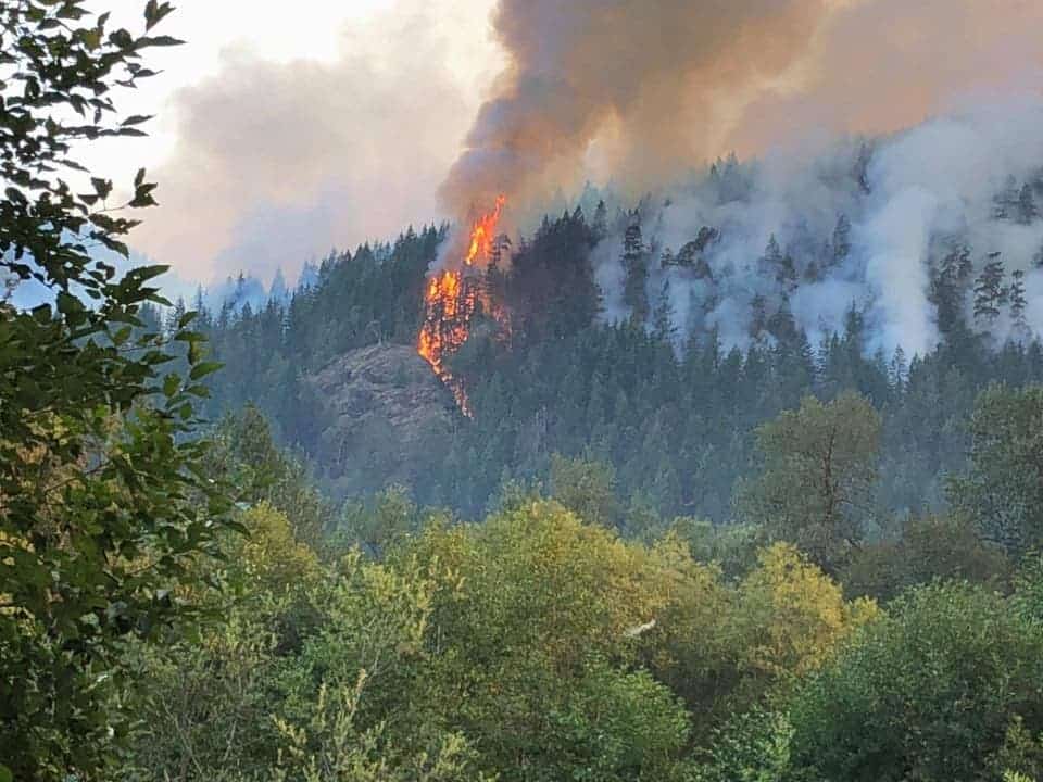
The Maple Fire in Olympic National Forest in Washington in 2018 burned 3,300 acres.Credit…USDA Forest Service
Here’s a link to an interesting New York Times story.
In the spring and summer of 2018, a crew of poachers had been chopping down trees by night in the Olympic National Forest in Washington State, federal prosecutors said.
On Aug. 3, they came upon the wasp’s nest.
It was at the base of a bigleaf maple, a species of hardwood tree with a shimmering grain that is prized for its use in violins, guitars and other musical instruments. The crew was selling bigleaf maples to a mill in Tumwater, using forged permits, prosecutors said. Logging is banned in the forest, a vast wilderness encompassing nearly a million acres.
The timber poachers sprayed insecticide and most likely gasoline on the nest, and burned it, the authorities said. But they were unable to douse the fire with water bottles, so they fled, prosecutors said.
The fire spread out from the forest’s Elk Lake area, near Hood Canal, burning 3,300 acres and costing about $4.2 million to contain, prosecutors said. It came to be known as the Maple Fire.
As to “Logging is banned in the forest, a vast wilderness encompassing nearly a million acres,” you might wonder if that is true (regardless of what might be meant by “wilderness” in this context), so I checked the handy Headwaters Economics version of the Forest Service cut and sold report, and it appears that in 2018 the Olympic sold 20,436 MBF, which suggests that in fact logging must not be banned. Perhaps what the prosecutors meant is that “logging without a specific permit or contract” is banned, which would make sense.
A government research geneticist testified at trial that the wood Mr. Wilke sold to a mill was a genetic match to three poached maple trees that investigators found in the Elk Lake area.
Like all living organisms, trees have DNA, the research geneticist who testified, Dr. Richard Cronn of the U.S. Forest Service, said in a phone interview on Tuesday night.
“They receive one set of chromosomes from their mom and their dad,” Dr. Cronn said. “That makes it possible to uniquely distinguish every tree out there if we have the appropriate genetic markers.”
In this case, researchers built a DNA database specifically for the Olympic National Forest, sampling 230 trees and coming up with an estimate that the probability of a coincidental match was one in one undecillion — or one followed by 36 zeros, Dr. Cronn said.
One limitation to a more widespread use of this technique in criminal prosecutions, Dr. Cronn said, is that databases must be created for individual tree species. This can be costly and time-consuming, he said, but he added that advances in genomics technology have made doing so easier.
“If you think about a human forensic database, you’re only making it for one species,” he said. “The trees that are targeted for timber theft across the U.S. are really different. We have maple in the Pacific Northwest, walnut in the eastern U.S. We would need a database for each of the species, so that is a bit of a barrier.”
Dr. Cronn said the use of tree DNA in this case would be a deterrent to similar theft.
He said researchers had created a bigleaf maple database of more than 1,100 tree samples, covering a region “basically from the U.S.-Mexico border all the way up to Vancouver Island and Canada.”
“Any time trees are taken in that range can now be investigated,” Dr. Cronn said. “We will be ready at the next trial.”
I’ve seen a variety of cool new technologies so thought I’d put them all in one post.
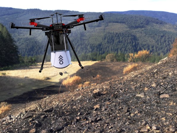
Drone seeding (if you watched the Bladon wildfire and hydrology seminar, you might reflect that aerial seeding in itself is nothing new). There is probably a history of direct seeding versus planting after fires, by location, somewhere. Still, doing it with drones is relatively new and could have some advantages.
I recently attended a Zoom Conference put on by Arizona State Extension on Biochar. A question came up in our group “why feed it to livestock?”. Apparently it’s allowed for food animals in Europe but not here (yet). This is why it’s good. Again, for sheep.
Hazing wolves. This is not new technology, but if you’re wondering how they do it at Yellowstone.
Drone technology is being used for tree-planting in response to afforestation and carbon sequestration needs, including use after wildfires. How might this change national forest management?
To quickly plant around a trillion trees—a goal that some researchers have estimated could store more than 200 gigatons of carbon—Flash Forest argues that new technology is needed. In North America, trees need to grow 10-20 years before they efficiently store carbon, so to address climate change by midcentury, trees need to begin growing as quickly as possible now. “I think that drones are absolutely necessary to hit the kind of targets that we’re saying are necessary to achieve some of our carbon sequestration goals as a global society,” she says.
But to restore forests that have already been lost, the drones can work more quickly and cheaply than humans planting with shovels. Flash Forest’s tech can currently plant 10,000 to 20,000 seed pods a day; as the technology advances, a pair of pilots will be able to plant 100,000 trees in a day (by hand, someone might typically be able to plant around 1,500 trees in a day, Ahlstrom says.) The company aims to bring the cost down to 50 cents per tree, or around a fourth of the cost of some other tree restoration efforts.
This has obvious implications for tree-planting crews, but how about something like salvage logging? Other issues?
If there were a The Smokey Wire Fix Not Fight Timely Innovation Award, this effort by the Colorado Mountain Club would be a winner. We’ve been talking about keeping track of recreation impacts and here is a way for volunteers to provide information, and also for volunteers to help fix the problems. I’m sure others have been frustrated by wanting to report something on a trail and not having the time to figure out which District you’re on, or want to call around to find the Recreation staff. And if it’s that hard for retirees, it must be more difficult for others.
Below is some information about the RIMS app and here’s a link to an overview pdf. Here’s the website where you can take a training video and learn to use the app.
Features
• Geo-located point data
• Drop-down surveys & objective metrics
• Photos
• Online maps & functionality
• Cloud sync for real-time data
Users
• Agency Staff
• Stewardship Organizations
• Trained Volunteers
• Enabled for Android or Apple devices
• Simple & Easy to Use!
Accessibility
• Trail, Campsite, Sign, Facility & Visitor Use
Assessments
• No Cost for data collection
• Custom Assessment Development (invasive species,
wildlife monitoring, etc.)
The CMC folks worked with agency staff to develop it, and here’s how agency staff and volunteers can use it:
There are a few ways both agencies and stewardship groups can access the data –
· All assessments are viewable through the RIMS app itself and users (including agency staff) can filter the data by assessment type and date. We are adding a new “sharing” function in the next month which will allow a user to send the details of an assessment directly via email.
· The webviewer is a browser-based tool that displays assessments on a map an allows for some additional filtering.
· Finally, our customized reporting dashboards are available for land managers or stewardship groups this spring and include geographically filtered data (e.g. only assessment within a Forest Service Ranger District’s boundaries) as well as charts, graphs, maps, and full data exporting capabilities. The dashboards can also generate automatic email notifications on a daily/weekly/monthly basis to help direct rapid response stewardship work. For example, a trail crew leader might want a weekly report of all the new downed trees that have been reported on the district to help inform where to direct staff or volunteer efforts.
The workflow for resolving issues is as follows: App users can re-assess any survey in the RIMS app to update the current conditions at that location. For example, if a downed tree is reported June 1 and a volunteer hikes that same trail June 7 to remove the downed tree, they can re-assess the first survey, remove the record of the downed tree and the issue will be marked as resolved within the app database. If for some reason the volunteer does not use the app to report the work they completed, another user could hike the same trail at any point after that and re-assess the original survey to mark it as resolved. The re-assessments are also helpful for measuring change over time: for example, re-assessing a dispersed camping area year after year to measure growth of the site, increased vegetation damage, etc.
We are still working through some details of this workflow but the ideal scenario in the future is that we have enough folks using RIMS and re-assessing issues that we always have a relatively current view of current conditions on the ground.
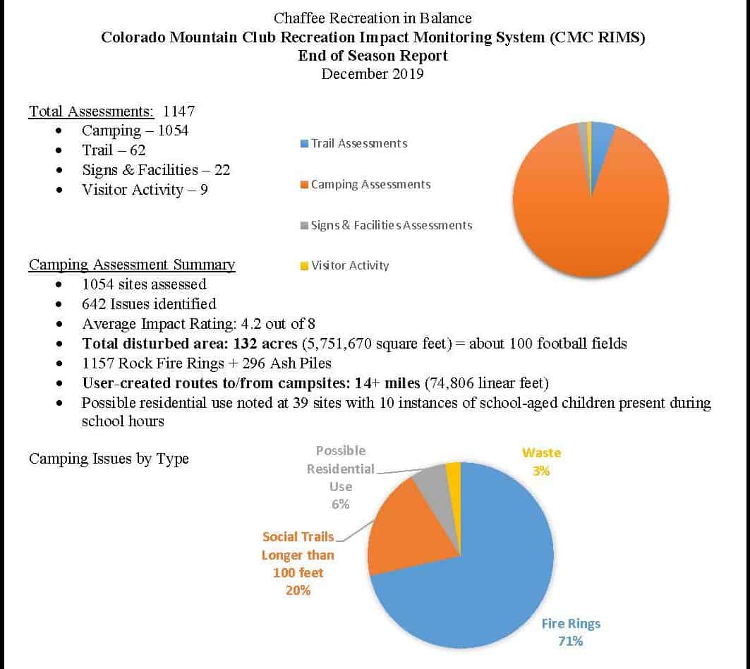
Here’s a link to a report from Chaffee County from July to November. My pet peeve that this could help with are dispersed campers that don’t respect the two week camping ban, or leave their trailers in a spot for what appears to be all of hunting season, taking up the choicest spots and not actually being there.
The image above is from the Chaffee County report. The CMC folks’ intention is to ultimately go national, so please spread the word in your area!
Whatever the color of the Administration, the relatively obscure wheels of scientific research and development continue along well-worn paths (whether the wording of the day is “low carbon” or “affordable, reliable and secure”). As I recall from my time in R&D, scientists readily change the title, and perhaps some introductory paragraphs, and voila! Thanks to the Forest Business Network for this link.
The U.S. Department of Energy (DOE) is providing up to $79 million in funding for bioenergy research and development including biofuels, bioproducts, and biopower. This funding supports DOE’s goal of providing consumers and businesses with a range of domestic energy options that are affordable, reliable, and secure.
Topics areas for the biofuel funding opportunity include the following:
Cultivation Intensification Processes for Algae: Develop technologies for outdoor algae systems that increase the harvest yield, reliability and quality of algae.
Biomass Component Variability and Feedstock Conversion Interface: Research to lower the cost and improve the reliability of biomass handling and preprocessing.
Efficient Wood Heaters: Develop technologies to reduce emissions and increase efficiency of wood heaters for residential heating.
Systems Research of Hydrocarbon Biofuel Technologies: Integrate new technologies and processes in experimental prototype systems to improve and verify real-world performance and lower the cost of drop-in biofuels.
Optimization of Biomass-Derived Jet Fuel Blends: Identify and develop cost-competitive drop-in renewable jet fuel with improved energy density and lower particulate matter emissions.
Renewable Energy from Urban and Suburban Wastes: Support academic research and educational programs that focus on strategies to produce bioenergy and bioproducts from urban and suburban waste feedstocks.
Advanced Bioprocessing and Agile BioFoundry: Reduce the time and cost of developing biological processes for biomanufacturing fuels and products through the use of synthetic biology, low capital intensity methods, and continuous production systems.
Plastics in the Circular Carbon Economy: Develop biobased plastics with improved performance and recyclability and lower the cost and energy-intensity of recycling existing plastics through enhanced degradation.
Rethinking Anaerobic Digestion: Develop anaerobic processes or alternative strategies to enhance carbon conversion efficiency and lower costs of smaller scale wet waste systems.
Reducing Water, Energy, and Emissions in Bioenergy: Identify biofuels or bioproducts technologies with the greatest potential for reducing water consumption, energy consumption, and/or emissions relative to existing conventional fuels or products.
This FOA also supports the Water Security Grand Challenge, a White House initiated, DOE-led framework to advance transformational technology and innovation to meet the global need for safe, secure, and affordable water. In particular, this funding will support research and development focused on anaerobic digestion, a technology that can help achieve the Grand Challenge’s goal to double resource recovery from municipal wastewater.
I particularly like the “wood heaters” project because there are many low-income people already use this as a primary heating source. New cool technologies are cool, of course, but making old uncool but widely used wood heat work better is also important.