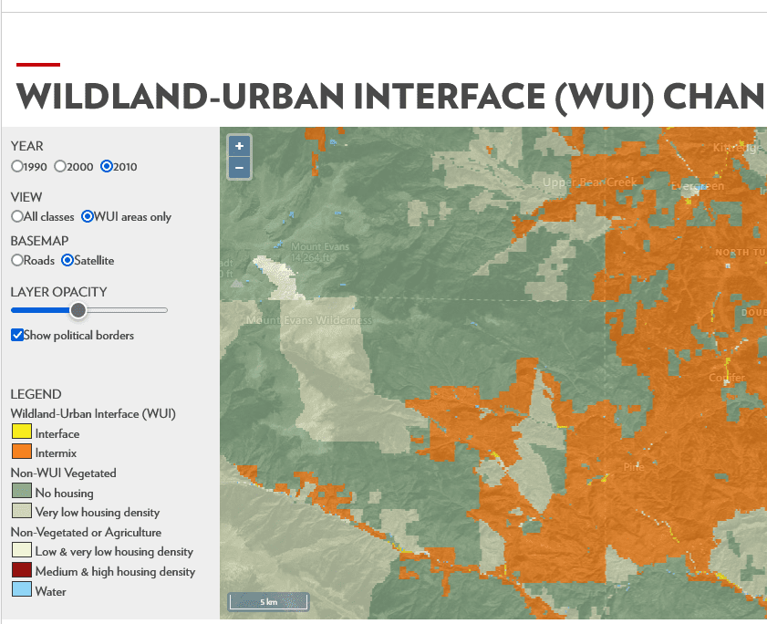
The Wildland-Urban Interface Defined
Although the idea of a wildland-urban interface is easily understood and the term widely used, a specific definition is needed to determine where it occurs and map its location. The definition we use here, as in earlier map projects, is designed to inform fire policy and management. It is based on a report prepared for the Council of Western State Foresters on WUI fire risk (Teie and Weatherford 2000) and was later published in the Federal Register. The WUI is composed of both interface and intermix communities. The distinction between these is based on the characteristics and distribution of houses and wildland vegetation across the landscape. Intermix WUI refers to areas where housing and wildland vegetation intermingle, while interface WUI refers to areas where housing is in the vicinity of a large area of dense wildland vegetation.
For more detail, see Box 1.Box 1.—Definition of WUI and non-WUI land-use classes.
WUI Definition
Intermix Areas with ≥6.18 houses per km2 and ≥50 percent cover of wildland vegetation
Interface Areas with ≥6.18 houses per km2 and <50 percent cover of vegetation located <2.4 km of an area ≥5 km2 in size that is ≥75 percent vegetated Non-WUI, Vegetated No housing Areas with ≥50 percent cover of wildland vegetation and no houses (e.g., protected areas, steep slopes, mountain tops) Very low housing density Areas with ≥50 percent cover of wildland vegetation and <6.18 houses per km2 (e.g., dispersed rural housing outside neighborhoods) Non-Vegetated or Agriculture Low and very low housing Areas with <50 percent cover of wildland vegetation and density <49.42 houses per km2 (e.g., agricultural lands and pasturelands) Medium and high housing Areas with <50 percent cover of wildland vegetation and ≥49.42 houses density per km2 (e.g., urban and suburban areas, which may have vegetation, but not dense vegetation)
What you might notice is that WUI on these maps can be adjacent to grazing lands or agricultural lands. Which doesn’t seem to fit the definition above, so this is more complicated than it might appear. Certainly acres of WUI next to corn fields or a grassy pasture have different fire characteristics than, say, a ponderosa forest.
This 2007 paper by Stewart et al. has a literature review and some history on the WUI concept.
Throughout its evolution, the WUI definition always includes three components: human presence, wildland vegetation, and a distance that represents the potential for effects (e.g., wildland fire and human activity) to extend beyond boundaries and impact neighboring lands. Beyond these three components, most WUI discussions are imprecise regarding what is or is not included. For example, human presence has been defined by housing density, population density, number of houses, or configuration of housing developments and neighborhood characteristics. Wildland vegetation is always mentioned, but the density, extent, and type of vegetation that makes some vegetation “wildland vegetation” is not well defined. The distance that the WUI extends into wildlands or into a housing development has been described in many different ways, including the distance a golf ball will fly off the porch or the distance from which flames or firebrands can reach a structure (Summerfelt 2003), but specific distances are rarely given.
It’s interesting to look at your neighborhood and compare the 1990 and 2010 maps. Observations?
There are lots of definitions of WUI, and the relevant one depends on a number of factors. This blog post provides a good short summary. (The same is undoubtably true for “intermix.”)
https://lawprofessors.typepad.com/land_use/2016/10/planning-for-wildfire-in-the-wildland-urban-interface-part-3-defining-the-wildland-urban-interface-a.html
The one most relevant to the Forest Service is the legal definition found in the Healthy Forests Restoration Act. It’s been the subject of recent litigation, including the Hanna Flats project on the Idaho Panhandle National Forest. Here’s what the court said there: “Although a county’s wildfire protection plan can be relied upon in assessing the wildland-urban interface, where, as here, a wildfire protection plan defines the wildland-urban interface differently than HFRA, the
wildfire protection plan definition cannot provide the “justification for a categorical exclusion under HFRA.” (The opinion linked to AWR v. Pierson in this Litigation Summary includes the HFRA language: https://forestpolicypub.com/2021/08/02/nfs-litigation-weekly-july-30-2021/)
The planning question here, assuming that the WUI would be managed differently from other parts of a national forest, is that WUI is a “management area” as defined by the Planning Rule, and can only be created or changed by amending a forest plan. A forest plan needs to be clear what definition of WUI it uses in the plan to delineate this area, and the Forest Service needs to be clear that a forest plan can’t just prospectively write a blank check to adopt future WUI maps created or changed by others.