The World Turned Upside Down- Or Rightside Up?: Interior West Universities Get $20 Mill from the Infrastructure Bill

This is a screenshot of the New Mexico Vegetation Treatments Database


I heard a rumor that CFRI hadn’t asked for this funding in the Infrastructure Bill. Anyone who knows the backstory, please let us know. Personally, I like the fact that the money didn’t get apportioned via panels of scientists, nor go to the Usual Coastal University Suspects.   One person’s pork is another person’s equity and justice, and all that.  It makes sense to me that universities in dry forests are better positioned to study the problem, which is to a large degree, fires in… dry forest types.

Here are some excerpts from the CSU press release

In an effort to improve forest resilience and reduce the risk of catastrophic wildfires in the Interior West, three organizations, including Colorado State University’s Colorado Forest Restoration Institute, are receiving $20 million from the U.S. government.

The funds are part of the Infrastructure Investment and Jobs Act passed by Congress with bipartisan support and signed by President Joe Biden in 2021, which will go to enhancing key systems and processes to mitigate the impact of forest fires.

The award will be made to the Southwest Ecological Restoration Institutes, which includes the Colorado Forest Restoration Institute as well as Highlands University’s New Mexico Forest and Watershed Restoration Institute and Northern Arizona University’s Ecological Restoration Institute. The Southwest Ecological Restoration Institutes were created through congressional legislation passed in 2004 and charged the three institutes with promoting adaptive management practices to restore the health of fire-adapted forest and woodland ecosystems of the Interior West.

……………..

The three institutes will work collaboratively on three key components with the funding. They will develop a national database of existing data on fuel treatments and wildfires, work with managers, planners, and policymakers to facilitate use and applications of the data, and research outcomes of forest management and wildfires to learn what works.

“The work we’re charged with developing under the Infrastructure measure will create opportunities for land and fire managers, scientists and community stakeholders to co-produce actionable knowledge to lessen the harmful effects of wildfire events to people and the environment,” said Tony Cheng, director of the Colorado Forest Restoration Institute and professor in the Department of Forest and Rangeland Stewardship.

……

“When land and fire managers, scientists and stakeholders work together to craft and apply science-based solutions, we can better realize this goal.”


Here’s an interview with the New Mexico Highlands folks

Barton said SWERI will receive the funding over five years and he anticipates that they’ll begin building the national database by starting in the Southwest and expanding out from there.

“The hardest part of this is just identifying all the treatments and keeping up with all the new treatments,” said Barton. “Part of what we need to do is figure out how much of what we’ve done in New Mexico is going to be relevant to what people need elsewhere, and then find local partners who can keep that going.”

Katie Withnall and Patricia Dappen, GIS specialists with the New Mexico Forest and Watershed Restoration Institute, pose with a drone outdoors

Katie Withnall and Patricia Dappen, GIS specialists with the New Mexico Forest and Watershed Restoration Institute, have mapped more than 50,000 vegetation treatment projects in New Mexico. 

Withnall said several other states already have some form of a treatment database, though to her knowledge none are as comprehensive as New Mexico’s.

“There are a couple of national databases, but they are not nearly as complete and don’t have the same scope,” said Withnall. “We do need to see what else is out there though so we’re not reinventing the wheel.”

And here’s a link to an interview with Andrew Sánchez Meador of Northern Arizona University’s Ecological Restoration Institute.

It’s a national effort, you’ll be looking at all different types of forests, right?

Yeah, a national effort, all types of forests. We anticipate that the things we do in the Southwest as SWERIs may not work everywhere. We may have to engage entities in Florida or Alaska that we don’t normally engage in Arizona, New Mexico, and Colorado. There’s a component in the beginning of this project that’s going to have to be around scoping, and ensuring that we have the right people at the table, and ensuring that this data product that will be put together and the outcomes from it will be useful for the largest group possible.

National Wildfire Crisis Strategy Roundtables:I. What They’ve Heard and What You Think


The Forest Service via the National Forest Foundation is setting up a series of roundtables to get feedback and help on carrying out their Wildfire Strategy.  Check out the NFF site here.

In January 2022, the USDA Forest Service released Confronting the Wildfire Crisis: A Strategy for Protecting Communities and Improving Resilience in America’s Forests. The Forest Service is working to develop a “living” 10-year Implementation Plan for working with partners across jurisdictions to change the trajectory of wildfire risk. The recently enacted Bipartisan Infrastructure Law provides an essential down payment on the resources needed to perform this work.

Everyone has a leadership stake in moving from small-scale, independently managed treatments to strategic, science-based, landscape-scale treatments that cross boundaries at the scale of the problem, starting initially with those places most critically at risk. Ongoing communication about the 10-year strategy and implementation plan among the Forest Service, States, Tribal entities, and non-governmental partners is welcomed and encouraged.

Here’s a link to the kickoff presentation.

Below are some of the summary slides of the info they’ve already received.  What do you think? Anything you would add/delete or finesse?

From Where Wildfires Start to the Forest Service 10-Year Strategy: Tracking the Logic Path of the Downing et. al Paper

Many thanks to Matthew for posting the Downing et al. paper from Nature. There are so many fascinating things about this paper, I thought it was worthy of looking at carefully. 1) what the paper says (results) 2) how those relate to the methods (logic paths) and 3) how the conclusions made their way from the paper to the OSU public affairs and other media reports.  It’s a terrific example, because you don’t have to understand the methodologies to understand the knowledge claims and logic.  I’m hoping this analysis will be helpful to students and the paper is open source so anyone can view. This is a longer post than usual.

The first step is always to look at results and discussion.

Conclusion
Our empirical assessment of CB fire activity can support the development of strategies designed to foster fire-adapted communities, successful wildfire response, and ecologically resilient landscapes.

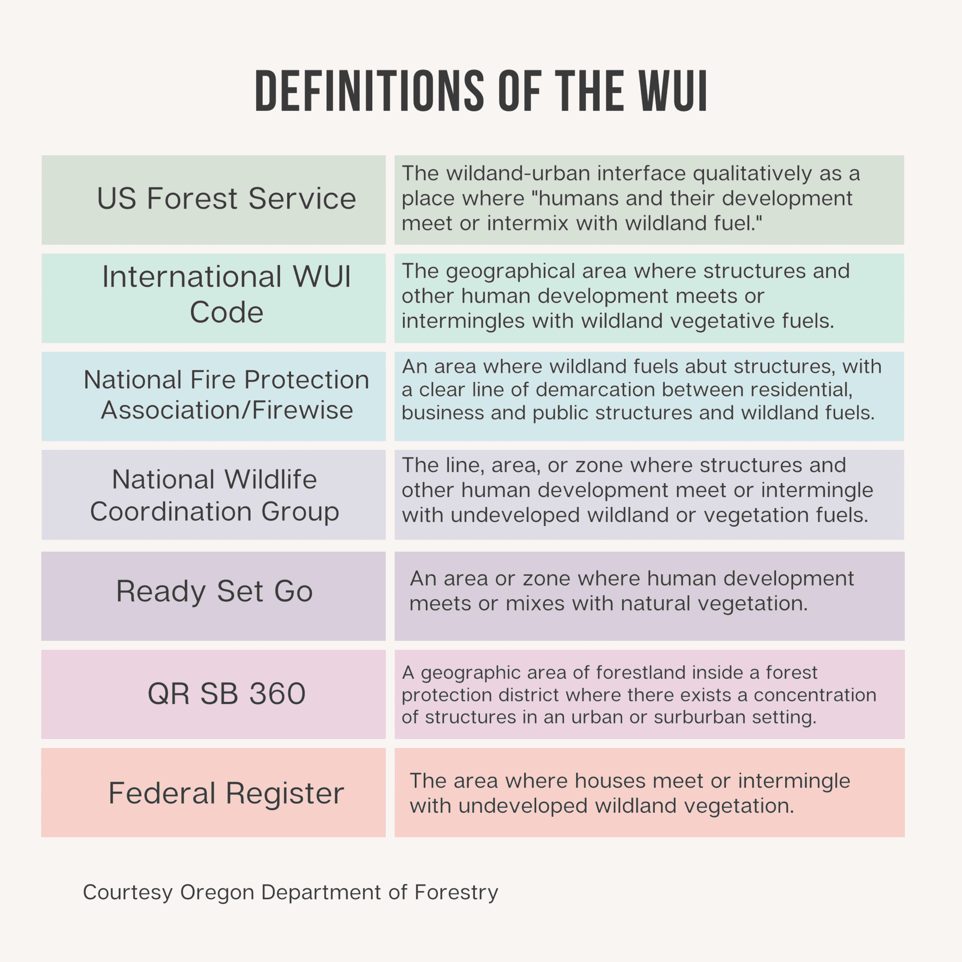
Then try to translate this from academic talk.  First, they talk about “cross boundary” wildfire, in fact, the whole paper is about “cross boundary” wildfire, so that is fires that move from private to public land or vice versa.  Why is this important?  They discuss this in a few paragraphs.

The tension between ecological processes (e.g., fire) and social processes (e.g., WUI development) in mixed ownership landscapes is brought into stark relief when fire ignites on one land tenure and spreads to other ownerships, especially when it results in severe damages to communities on private lands and/or highly valued natural resources on publicly managed wildlands. These cross-boundary (CB) wildfires present particularly acute management challenges because the responsibilities for preventing ignitions, stopping fire spread, and reducing the vulnerability of at-risk, high-value assets are often dispersed among disparate public and private actors with different objectives, values, capacity, and risk tolerances23–25
. Some CB risk mitigation strategies exist, such as fire protection exchanges, which transfer suppression responsibility from one agency (e.g., state) to another (e.g., U.S. Forest Service), and CB fuel treatment agreements, which allow managers to influence components of wildfire risk beyond their jurisdictional boundaries 2,26 . Improving CB wildfire risk management has been identified as a top national priority 27 , but effective, landscape-scale solutions are not readily apparent.
A common narrative used to describe CB fire is as follows: a wildfire ignites on remote public lands (e.g., US Forest Service), spreads to a community, showers homes with embers, and results in structure loss and fatalities 23,25,28 . In this framing, public land management agencies bear the primary responsibility for managing and mitigating CB fire risk, with effort focused on prevention, hazardous fuel reduction, and suppression—largely reinforcing the dominant management paradigm of fire exclusion 29,30 . An alternative risk management framing of this challenge has emerged, starting with the axiom that CB fire transmission is inevitable in fire-prone mixed ownership landscapes and that private landowners and homeowners are the actors best positioned to reduce fire risk to homes and other high-value assets regardless of where the fire starts 31 . In the absence of a broad-scale empirical assessment of CB fire transmission, it is difficult to determine which of these narratives more accurately reflects the nature of the problem, and whether CB fire risk management is best framed in terms of reducing fire transmission from public lands or decreasing the exposure and vulnerability of high-value developed assets on private lands.

So there’s a framing question here.  Where I live, people don’t much care where a fire starts, just if it’s burning close to them.  So the importance of addressing wildfire with the CB framing is based on a “common narrative” with cites 23, 25, and 28.  28 is an interesting paper by Ager et al., definitely worth taking a look at, about Central Oregon, where they found:

Among the land tenures examined, the area burned by incoming fires averaged 57% of the total burned area. Community exposure from incoming fires ignited on surrounding land tenures accounted for 67% of the total area burned.

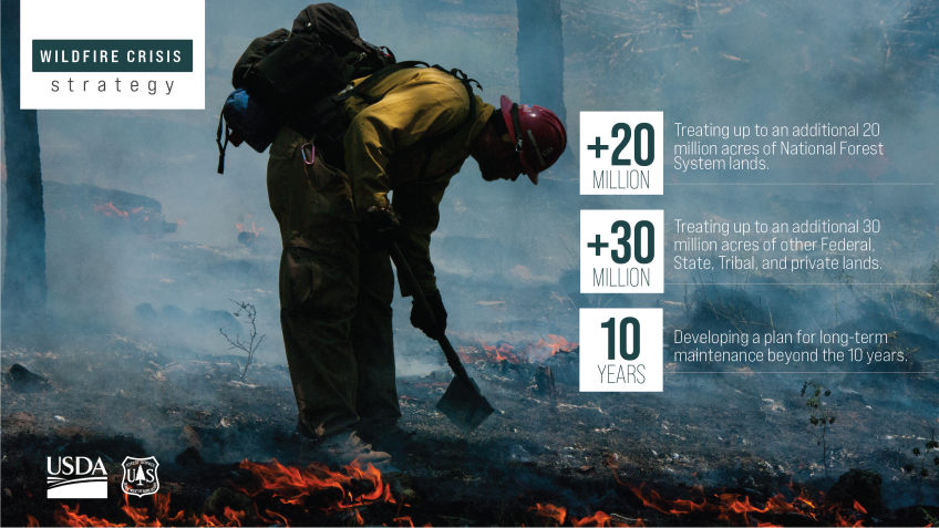
I would call that an observation, rather than a narrative, but perhaps I’m being pedantic.  For those who don’t track this stuff,  Ager’s groups’ transmission and scenario analysis forms the basis for the prioritization scheme in the Forest Service 10 year action plan.

As to “Improving CB wildfire risk management has been identified as a top national priority 27 , but effective, landscape-scale solutions are not readily apparent.”  I think this is important as in a brief review of their cite to the Fire Plan Implementation Strategy, I didn’t actually see a reference to “cross boundary”-  maybe others can find it.  The other thing I’d point out is that PODS look like they might be an effective landscape-scale solution and they seem apparent to me.  So outside of a scientific paper, that would be an interesting conversation to have.

I found the conclusions interesting as I have just spent several days working on the logic of “fires are increasingly difficult and unpredictable due to fuel accumulation, climate change and increasing amounts of human infrastructure, therefore we need to keep all the tools in the toolkit, including prescribed fire and the Thing Formerly Known as WFU.”  This was rather well-stated IMHO in Wildfire Resolution Letter on  TFKWFU:

As we have seen over the past few years, especially in California and Colorado, we are now experiencing conditions that are causing extreme fire behavior, which is in part due to past full  suppression policy. The best management approach we have to combat this phenomenon is reducing the amount of fuel available to burn. Similar to how important thinning and prescribed burning are around our communities, the ability to manage wildland fires at appropriate times is equally important for reducing fuels in the wildland environment. We will never be able to reduce fire risk to communities with thinning or prescribed fire alone—we need all hands on deck, and all the tools in the toolbox.

So it looks like the authors of the Downing et al. paper ended up in a different place from many other practitioners and the usual fire science suspects.  To me this is a Science Situation That Shouts “Watch Out.”

So that’s why we need to dig deeper.. let’s go to conclusions again in their paper.

Conclusion
Our empirical assessment of CB fire activity can support the development of strategies designed to foster fire-adapted communities, successful wildfire response, and ecologically resilient landscapes. Adapting to increasing CB wildfire in the western US will require viewing socio-ecological risk linkages between CB fire sources and recipients as management assets rather than liabilities. We believe that a shared understanding of CB fire dynamics, based on empirical data, can strengthen the social component of these linkages and promote effective governance. The current wildfire management system is highly fragmented 74 , and increased social and ecological alignment between actors at multiple scales is necessary for effective wildfire risk governance 14,30 .
Cross-boundary fire activity can contribute to multijurisdictional alignment when fire transmission incentivizes actors to collaboratively manage components of risk that manifest outside their respective ownerships 15 . A broader acknowledgement that CB is inevitable in some fire-prone landscapes will ideally shift the focus away from excluding fire in multijurisdictional settings towards improved cross-jurisdictional pre-fire planning and reducing the vulnerability of high-value assets in and around wildlands 30,31 . Federal agencies like the USFS can provide capacity, analytics, and funding, but given that private lands are where most high-value assets are located and where most CB fires originate, communities and private landowners may be best positioned to reduce losses from CB wildfire.


Now, first of all, it’s kind of hard to parse some of the academic-ese here “will require viewing socio-ecological risk linkages between CB fire sources and recipients as management assets rather than liabilities.”  I hope it’s clear to others, they lost me. 

“We believe that a shared understanding of CB fire dynamics, based on empirical data, can strengthen the social component of these linkages and promote effective governance.”  That’s nice that they believe that, but I’d be curious about the mechanics of how that works.  Communities have their own lived knowledge of fires and it’s hard to tell them “some scientists ran some simulations and came up with …. “.  And effective governance of HOAs, fire departments, counties, states and feds.. there are many problems at coordination at all scales, but not clear that modeling fire transmissions with their model will be more helpful than all the other fire transmission models that have existed for some time.

“shift the focus away from excluding fire in multijurisdictional settings towards improved cross-jurisdictional pre-fire planning and reducing the vulnerability of high-value assets in and around wildland”  Hmm. We have a system that includes both- a very complicated process and alignment of CWPPs, federal lands and and suppression that takes into account all of the above.  Perhaps the authors have developed a straw person? or are they saying “leave the federal lands alone and focus on communities?”  Which wouldn’t be “all hands all tools”? Or perhaps a change in focus? But then you’d have to articulate what the current focus is and what needs to change.

An alternative risk management framing of this challenge has emerged, starting with the axiom that CB fire transmission is inevitable in fire-prone mixed ownership landscapes and that private landowners and homeowners are the actors best positioned to reduce fire risk to homes and other high-value assets regardless of where the fire starts

I agree that private landowners and homeowners , utilities, ski areas, water providers are best positioned to reduce direct risks.  But there are also people (fire suppression folks) working assiduously to keep fires away from infrastructure- and it actually works most of the time (I don’t have a cite, but I can see information on InciWeb).  This is a both/and thing.  Not sure how the simulations in this paper support changes to the current system.  If I’d reviewed it, I would have asked them to draw a logical line between “the system as we see it” “what our data show” and “how we think this information should inform changes.”

And here’s a quote from the OSU piece:

“The Forest Service’s new strategy for the wildfire crisis leads with a focus on thinning public lands to prevent wildfire intrusion into communities, which is not fully supported by our work, or the work of many other scientists, as the best way to mitigate community risk,” Dunn said.

I think this doesn’t take into consideration that that the strategy is the FS chunk of the overall work, of which there are many other bucks going to states and ultimately into communities.  They did not say it’s the best way, only what they can contribute.  Plus thinning and PB have other desirable attributes in making forests more climate-resilient, so not so much destruction occurs within them in the case of a wildfire.  Suppression folks work with a great variety of values at risk that include but are not restricted to communities.

What I would have said based on the data?  More fires go into the NFs than come from the NFs based on the data.  So working on reducing ignitions and spread before fires get to the FS boundary would be a good idea.  But everyone gets to conclude what you want from the data.. what do you conclude?


The WUI is Dead. Long Live the WUI: FAC Net Post by Ed Keith

I thought that this post on “the WUI is dead” was relevant, both to many discussions here (one example here) and also to the later Marshall Fire in Boulder. Shout-out to FAC Net who always posts good stuff.

The WUI, at its core, was a term meant to describe a perceived problem; now it is used to demarcate a perceived place. A short look at a few examples illustrate the issues with this shift:

The Sleepy Hollow Fire burned into Wenatchee, Washington in June of 2015, in what might have first appeared as a classic WUI fire, with a wildfire burning up to the edge of the city and igniting nearly 30 homes. As firefighters were busy fighting the fire in the Broadview neighborhood, embers from the burning homes travelled to the downtown core igniting and damaging multiple businesses. Subsequent mapping by the Washington DNR shows that this downtown area is not part of the WUI.

The Tubbs Fire burned 5,636 structures in and around Santa Rosa, California, and just over 25% of those structures were in an area too densely developed to be considered WUI, and another 4% too sparsely developed to be considered WUI. That’s over 1600 structures lost to a single wildfire that weren’t part of the WUI!

Closer to home, Deschutes County, Oregon defined a “wildfire hazard zone” that encompasses the entire County in 2003. It was just too difficult to think that an area of the county wasn’t at some level of wildfire risk. Would this zone be so all encompassing today if we tried to define WUI instead of the wildfire hazard zone? We’ll see soon as the State is due to complete the task of mapping said WUI by June of 2022.

What is in a name, indeed? At its outset, WUI was used to describe an emerging issue. Now some are more focused on deciding who is in or out of it. And what is implied by being in or out of a WUI? If you are not located within the WUI the implication I get is you don’t have to worry much about wildfire, but that may send a dangerous message, and is leading us away from using an inclusive approach that is needed for communities to begin to live with fire.

When I really start to think about it, using the term WUI oversimplifies the landscape it tries to represent, with all its complex social, political, economic and environmental issues overlaid on an ever changing geography. It implies there are areas in our communities without any risk, it allows us (from residents to decision-makers) to point the finger of blame and transmission at “others” or those who live somewhere else, and our obsession over mapping it perfectly keeps us from dealing with the real issues of adaptation and resilience our communities face.

The WUI may work, albeit imperfectly, as a concept, but it’s not meant to be a geographical place. The WUI isn’t a place at all, it is a set of conditions, and the more we try to define it and map it, the more we’ll have to disagree about.

I submit that it is time to sweep the term WUI to the curb, admit that the issues we’re trying to solve are more complex than something that can be captured in three words, and get back to work restoring our forests and rangelands, improving our wildfire response and continually adapting our communities to the fire adapted ecosystems we are all living in. The WUI is dead. Long live the WUI.

Chief Moore and Secretary Vilsack Announce New Wildfire Strategy

Smokey Wire Folks… you are invited to comment on any of the documents on this Confronting the Wildfire Crisis website.  There’s much to discuss, so we may have to break the topics down later.

Confronting the wildfire crisis: A new strategy for protecting communities and improving resilience in America’s forests


Official Portrait: Chief Randy Moore.
Chief Randy Moore

Please join USDA Secretary Vilsack and me virtually today at about 1:40 p.m. Eastern as we announce a new national strategy to confront the wildfire crisis facing the nation, which has threatened and destroyed lives, homes, land and communities, especially in the West. This historical announcement marks a paradigm shift in the scale of our fuels and forest health treatments to match the actual scale of wildfire risk.

For some time now, our limited resources have constrained us. Despite that challenge, your “Can Do” spirit allowed us to go above and beyond what should have been possible. Our collective efforts have yielded astonishing results and earned the trust of communities and lawmakers.

That said, we all know there is still so much work to do. Climate change is driving hotter, longer and more severe wildfire seasons, and wildfire behavior is becoming less predictable. Because of your efforts and the relationships you have created and maintained, our approach to these challenges is about to change. The Bipartisan Infrastructure Law provides nearly $3 billion to reduce hazardous fuels and restore America’s forests and grasslands, along with investments in fire-adapted communities and post fire reforestation.

This investment and the public trust to deliver results require us all to change the way we think about our work. We must think innovatively about how to use these resources to confront the wildfire crisis in the West. This is the core of our mission to sustain the health and diversity of the nation’s forests. This is what we’ve been working toward for so long, together.

Take a moment to let this sink in. We can change the trajectory of catastrophic wildfires in the West. We will capitalize on our science, partner relationships and land management expertise to confront the massive scale of the problem. This is our moment to innovate. Let’s not be afraid of what is unknown, rather focus on what can be with our collective effort. All our priorities matter and we will work together to achieve them.

As the challenges we face in land management evolve, so must our approach to those challenges. We must open the door to engage and co-develop into the future. The Forest Service will work with other federal agencies, including the Department of the Interior, and with tribes, states, local communities, private and family landowners, industry and other partners to focus fuels and forest health treatments more strategically and at the scale of the problem based on the best available science. Working together toward common goals across boundaries and jurisdictions is essential to the future of these landscapes and the people who live there. We’re in this together.

Our values will guide us on this journey. I have never felt them more aligned to our work than now. Service—I can’t think of anything more significant than improving the health and resilience of millions of acres of forests and grasslands and protecting numerous communities across the United States. Interdependence—We can’t do this alone. We need partners, those we know and those we are yet to engage, and communities to help us achieve success. Conservation—This work is the definition of conservation. Diversity—We’re going to use new ideas and bring in different perspectives to confront this crisis. The strength we will derive from different experiences and understanding of this work, including insights from traditional ecological knowledge and historically underserved communities, will be an important part of our success. Safety—We’re protecting communities and improving health through clean air and water, and lessening contributions to climate change. This effort will also help our wildland firefighters, providing them with safer anchor points in and around treated areas as they continue to do critical suppression work to protect communities, watersheds and critical infrastructure.

We already have the tools, the knowledge and the partnerships in place to begin this work and now we have the funding that will allow us to build on the research and the lessons learned to address this wildfire crisis facing many of our communities. I thank Congress, the president and the American people for entrusting us with this important work.

Thank you for joining me on this journey. Please visit the Confronting the Wildfire Crisis website for more details about the new strategy.


Artwork: Wildfire Crisis Strategy.
The 10-year Wildfire Crisis Strategy will allow us to treat up to an additional 20 million acres on National Forest System lands; treat up to an additional 30 million acres of other federal, tribal, state & privately owned lands; and develop a plan for long-term forest maintenance that extends beyond the 10-year strategy. USDA Forest Service artwork by Caitlin Garas.

What the FS Should Do To Manage the Flood of Bucks re: Wildfire Resilience: Convened by Aspen Institute and TNC


Rumor has it that Secretary of Agriculture Vilsack and Chief Moore will make an announcement about the 10 year plan next Tuesday.  Meanwhile, the Aspen Institute and TNC convened a set of folks (would it be overreaching to say “many of the usual suspects”? you decide, guest list here).

Here’s a link to the report.

Earlier we received some inklings about the work of the WRRIT from Chief Moore at the SAF Convention as described in this “premonitions” post..  Here’s what the Aspen/TNC report says.

In September 2021, the Forest Service established an internal Wildfire Risk Reduction Infrastructure Team (WRRIT) to develop a ten-year strategic implementation plan to address wildfire resilience across the U.S.
WRRIT is working to:
1) clearly understand the funding and legislative requirements (including congressional direction), and how to prioritize hazardous fuels, prescribed fire, and workforce development projects;
2) identify the internal needs to operationalize the incoming surges in funds, specifically related to capacity, internal policy, infrastructure, technology, and business practices, among others;
3) develop strategic plans and designs to address wildfire resilience at scale while providing flexibility for geographic differences; and
4) socialize and communicate the science and scenario planning, as well as how to engage with employees, partners, and others to get their input and communicate the need for action.

I’m for any team who has an objective of socializing, but I’m not sure that we mean the same thing by the term..

As we talked about before, a key difficulty with national prioritization has been pushback from those who would receive less. Pluse there’s already many different prioritization processes in place.. for example Colorado has its own risk mapping to focus mitigation priorities. Here’s what this group had to say:

Forest Service leadership explained that firesheds will be a major component of the initial prioritization process, yet many participants expressed concern about using the fireshed model as the base map or as the only prioritization tool. For instance, congressional constraints may not align perfectly with fireshed model parameters. In addition, many states are neither familiar with nor using the “firesheds” concept and few have adopted the prioritization tool as part of their State Forest Action Plans. Workshop participants suggested that location in critical firesheds could be a criteria and a preference, but perhaps should not be a definitive requirement. Instead, participants offered that there could be multiple screens used to identify priority locations, and the agency should find ways to move between and sequence screens based on context. Additional prioritization screens could include watersheds and collaborative planning (e.g., Community Wildfire Protection Plans, shared stewardship agreements, forest action plans).

Equity Considerations
Advancing greater equity will also likely play into the criteria for selecting priority landscapes. For example, starting with projects that have collaborative history might make sense, but those are often places with a history of investment and an active partner environment (e.g., universities, NGOs, and other active stakeholders). Focusing solely on these high-capacity areas, despite being high risk, can leave behind certain places and communities, including those that have been historically underserved. Participants agreed that there must be a balance between projects that are ready to go (in places that have capacity, created by the existing system) and investments in those places that could benefit from increased capacity and outcomes. If criteria and prioritization screens do not explicitly include equity considerations, the need for expediency will likely lead to investment in the usual places, projects, and groups, and not result in the needed paradigm shift.

There has definitely been a sense of “them that has, gets” in terms of CFLRPs and other funding sources. However, it might be desirable to define more clearly what we mean by “underserved.” Ideally it would be desirable to bring each area up to “CFLRP level” in terms of interested universities, partners and so on. It might take other colors of dollars to support that capacity. In fact, building the underserved to CFLRP-like capacity would be a useful exercise far beyond wildfire resilience IMHO.

One way to plan for fuel management and fire response is to use Potential Operation Delineations (PODs). PODs are fire management planning units that are defined by boundaries like roads and ridge tops, within which risks can be quantified. While there is significant funding targeted for POD adoption, it is not yet a widely known practice. The agency is making strong investments into the development of PODs and those will likely have to be brought into the agency’s work in years 1-2.
Implementing the surge in funding will likely require recognizing local context and variation and PODs could be a way to increase the application of prescribed fire and sustaining investments

This group seems to like PODS, but hasn’t gone as far as I’ve suggested-  to put a time-out to NFMA planning and work on PODs and fire planning for each western forest until they are all designated and NEPAed.

There were apparently no techie people at this conference, so perhaps that’s the reason for this rather gloomy observation..

Industry can play the role of removing material off the forest and utilizing products in innovative ways. However, too often the material is of low or no value. Participants noted that industry capacity takes time to build, and supply may need to be guaranteed. However, there needs to be more discussion about how to remove material that simply has no value and the investment needed to remove that material as a service rather than for profit.

Paying to remove it to me doesn’t really help to solve the problem of what to do with it. I think everyone agrees burning it in piles is suboptimal for climate. Then it’s a complicated question of how to use it in such a way as to reduce costs to the taxpayer, keep it out of the atmosphere, and make a profit if possible. Maybe that’s the next workshop…

Then there’s some of the usual partnership/EADM observations.. including the idea of a “partnership modernization effort” like the recent forest products modernization effort.

Complex Processes
Navigating the agency’s contracting system can be difficult. Contract administration, compliance, recordkeeping, reporting, accounting, and liability insurance are hard for potential partners, especially those with limited capacity. Some partners shared that it can be hard to advance local innovative approaches that end up getting stalled as they run through layers of bureaucracy. Other complex processes raised included wildfire liability insurance, cancellation and termination clauses in stewardship contracts, and reimbursements instead of upfront funding. Agency standards (e.g., multi-party stewardship agreements, revisions to template arrangements) and national level approval processes should be nimbler.

Personnel Transition Management
Inconsistent personnel can pose an additional challenge for partners. Detailees and personnel lost to fire assignments represent barriers to relationship building. Partnerships rely on building trusting relationships, which can be challenging when Forest Service employees move frequently.
As surges in funding materialize, participants agreed that the agency needs to assess its internal policies and systems to see where it can reduce hurdles to partnerships. There may be a need for partner liaisons — which could be inside or outside the agency — to help navigate partnership challenges. More broadly, the agency may need to pursue a partnership modernization effort, like the recent forest products modernization effort.

I’m a fan of Forest Products Modernization.  To me it’s partially an internal exchange of neat ideas and projects among FS people,  but it’s hard to develop a picture (from the outside) of changes to procedures and removing barriers.. maybe an annual summary of those kinds of changes would be helpful? Maybe they are there, but I haven’t seen them.

Anyway, if you’re interested, take a look at the recommendations and see if you find any surprising, or support or take issue with any.

Jerry Perez is New Director of Fire and Aviation Management for the Forest Service

Jerry Perez, new USFS National Director of Fire and Aviation Management. USFS photo.

Perhaps it will be of interest to TSW readers with a legal background that Jerry has a law degree, as well as having been the National Litigation Coordinator for the Forest Service.

Also that he has BLM experience as a State Director.  While I think it’s useful for anyone to have experience in both multiple use agencies,  I think it’s particularly important when Fire is run as an interagency effort.

“I welcome Jerry’s 32 years of experience and expertise as he leads our outstanding firefighters and guides the fire and aviation program to meet the challenge of preventing and managing wildfires,” said Forest Service Chief Randy Moore. “He steps into this position as the agency focuses on significantly increasing the pace and scale of hazardous fuels treatments focused in areas that have the highest risks of wildfires and threats to vital infrastructure.”

Here’s a link to his bio. Jerry has over 32 years of federal service across the country in varying roles (and Chief Moore has (43!).
It’s hard to worry about the future of the Forest Service when it’s in such capable hands. If they make mistakes.. it won’t be through lack of experience.

Congratulations, Jerry!

The Marshall Fire: Wind, Grasslands, Suburbs and Towns

AP image of houses burned in the Marshall Fire covered by snow

A few thoughts on the tragedy of the Marshall Fire. I spend a fair amount of time in Boulder County, and watched the coverage in real time.

This is an area where no one expected a fire to have those kinds of impacts in those suburban neighborhoods. There’s been many grass fires and high winds but nothing before like this.

But given that and the speed that the fire moved,  evacuations apparently went smoothly. From what I’ve read, 35,000 people were evacuated and currently two are missing. Governor Polis called this “our New Year’s miracle.”

Not to speak of the difficulties of moving large animals quickly as in this video.

Governor Polis said that this wasn’t a wildfire, but rather a suburban and urban fire.  He pointed out that houses aren’t just houses but also homes, sanctuaries for families and “reservoirs of memories.” He got at the deeply personal and emotional aspect of losing your home.. something that is often in news stories, but harder for us wonky types to address (“social values?”) because we can’t quantify it.

Observing the reaching out of support across county and state lines, it was affirming that when tragedy strikes people want to help regardless of the divisions that occupy so much space in the media.

The Overwhelming Power of Overwhelmingly Bad Luck

Then there’s the almost unbelievably unlucky timing of the ignition event.  As you see in the photos above, there was a serious snowfall in the same area the next day.   If the ignition had happened Friday or later, the story would have been completely different. Or when it was not so windy.  Or perhaps later in the year when this snowfall has had a chance to stem some of the dryness.

Climate or Not (or “made more likely by some unknown percentage”)

Wildfire disasters have increasingly been characterized as due to climate change.  Historically, there have been a great many grass fires and high winds in the area, but until the last twenty years or so, not as many subdivisions.  So it seems like all those changes (grass burns fast, houses not) are interwoven, and difficult or impossible to tease apart.  Especially since the ignition source appears to be people living in places where they probably weren’t living twenty years ago.  For the foreseeable future we are stuck with a) whatever weather is happening and b) people’s need for housing in either grasslands, shrublands or forest (pretty much all we have to choose from in the Denver metro area). Here’s a story from the Colorado Springs Gazette that talks about some history and quotes some fire scientists in California.

Topography and development or lack of development, played a role in the disaster.

Boulder is rightfully proud of its open space.

The City of Boulder is an island of development in a ring of city and county open space. But open space means grassy prairies, and dry prairie grass has always been a serious fire hazard, just as it was in 1910.

This is from the Denver Post.

The snow’s arrival to the Front Range on Friday was expected to help authorities’ efforts to snuff the remaining fire.

However, climate scientists were unsure how much relief the snow ultimately will provide, given the increasing drought and warm temperatures the Denver metro area has faced this fall. The conditions, which have become more common due to climate change, provided all of the ingredients needed to spark a wildfire, they said.

“That’s made for a quite extreme climate,” said Becky Bolinger, assistant state climatologist at the Colorado Climate Center at Colorado State University. “We don’t experience that often.”

I’d argue that there is one more ingredient needed to spark a wildfire.. ignition. More likely in inhabited landscapes.

Importance of Gasoline-Powered Vehicles in Dealing with Emergencies and Their Aftermath

Furthermore, in order to adapt to current conditions (with an unknown component x of climate change)  communities need to use fossil-fuel powered vehicles to evacuate people and animals, fight fires, and so on. Also aircraft, in general, but in this case, they were unable to fly due to high winds in this case.

Over the break, I was catching up on my New Scientist reading.  NS is a publication from Britain. It seems common there for people to assert that for the sake of the environment people need to live in apartments, give up cars (including electric ones) in favor of public transit and riding bikes, and perhaps ride-sharing.  When it comes to evacuations, with fires moving at a great rate of speed, it’s easy to see that this approach could become a problem, and not just in rural areas. Not to speak of the trucks pulling the trailers to evacuate large and small animals.

Burning homes and other infrastructure release carbon, plus a variety of other nasty chemicals into the atmosphere.  People are going to rebuild.  New homes require lots of wood and other construction materials, plus large (fossil-fueled) trucks carrying them.  If the fires had been kept out of their communities and not burned their houses,  then that would seem to have less of a carbon impact. I’m a big fan of both/and- “preferably keep fires out of communities, but also homeowners invest in protection.”  I don’t really understand who decided that this should be either/or, or why anyone listens to them.

Fuels Always Matter

Grass burns differently than wooden fences, houses and so on.  One shot on the news showed the fire stopping where a farmer/rancher had had cattle grazing recently, as he said, due to less fuel. Perhaps there is a house proximity that is too close for fire conditions.  This is again an issue that would go against “densification is always great,” which is part of the current community planning view.

Everyone  Can Learn From Well-Funded Communities

More well-off communities are better equipped to deal with disasters.  There’s a great deal of different kinds of institutional and financial support. Broomfield and Boulder counties are among the counties with the lowest poverty rates in Colorado. While it may be a general truth that “disasters unequally affect the disadvantaged,” in certain cases disasters do affect the relatively advantaged. By studying how they approach the problem, other communities can learn. Among the houses that survived and the ones that were burned, will they be able to figure out differences? Or was it again some form of bad luck (wind patterns and so on)?

*********************************

My heart goes out to all who have been affected by this fire, and my appreciation for all those who have and are reaching out and helping. For those interested, here’s a list of places to donate.


Chief’s December Wildland Fire Direction Letter: Community Dialogues Around Wildland Fire Use

Chief Moore stresses the importance of prescribed and managed fire and asks R&D and S&PF to convene community dialogues around wildfire use.

In a December 20 letter to the Forest Service:

The 2021 fire year was especially challenging. With 99 days spent at National Preparedness Levels 4 or 5 our collective wildfire response capability was stretched for much of the summer. As a result of the exceptional response to ongoing wildfires at the time, I issued a letter on August 2, 2021, to modify our normal wildland fire practices to avoid further intensifying the demands on our employees and to commit our fire resources only in instances where they would have a high probability of success and they could operate safely and effectively. My letter gave
direction to limit prescribed fire and to refrain from managing wildfires for resource benefits. These were necessary steps to focus our collective attention on supporting wildfire response and
to limit further demands on our workforce, while anchored to our core values of safety, service, and interdependence.

On October 21, 2021, the National Multi-Agency Coordination Group reduced the National Preparedness Level to 1, indicating the national wildfire response workload had moved to a more manageable level and that weather and fuel conditions had changed for the better. As a result of these changes, we will resume using all the tools in our toolbox when and where appropriate. Only by significantly scaling up fuels treatments can we change the destructive impacts wildland fires are having. Our fire science has demonstrated we need to not only mechanically treat fuels, but we need to use fire to finish the treatment cycle and truly restore resilient, fire-adapted landscapes. As such, it is important we resume our work to mitigate future wildfire risks by taking proactive steps where and when opportunities present themselves to apply fire in the right place, at the right time, and for the right reasons. This includes using prescribed fire and taking a risk-based approach to managing natural ignitions for resource and fuel treatment benefits. We will do this based on science and where appropriate according to our Forest Management Plans.

In the meantime, it is also critically important we continue to engage with partners and others around the use of these tools. I recognize the use of fire as a management tool, especially wildland fire, can generate a lot of concern and is controversial in many communities. We need to engage in robust, open conversations with citizens and partners about the proper use of managed fire and the science supporting it. It is vital we all reach an understanding of what defines a managed fire and what difference it makes in protecting communities and creating resilient forests. We need to understand when and how we appropriately use this tool and under what conditions. As such, I have asked the Deputy Chiefs of Research and Development and State and Private Forestry to convene community-based dialogues. I am committed to an ongoing dialogue with our partners about the appropriate use of these tools to make sure we follow safe and effective risk management principles to protect people and keep our firefighters safe. Only together can we create resilient landscapes and communities.

Let us continue to honor our fallen by remaining committed to one another’s health and safety by allowing adequate time for rest and recovery as we resume our wildland fire management activities. Thank you again for all that you have done and continue to do on behalf of the American people.

My bold.

Science Friday: Law et al. Paper on Prioritizing Forest Areas for Protection in 30 x 30

We’ve looked at two scientific papers in the last week,  last Friday Siirila-Woodburn et al.   “low to no snow future and water resources” as we discussed here.  Then yesterday we took a look at Ager et al. 2021. as part of a discussion about the Forest Service 10 year wildfire risk reduction plan.  Today I’d like to look at a recent paper by Law et al. that Steve brought up in a comment yesterday. It’s interesting for many reasons, not the least of which is that the journal, Communications Earth and Environment publishes the review comments and responses, and is open access. Apologies for the length of this post, but there’s lots of interesting stuff around this paper.

The first question is “what is the point of the paper?”  In the discussion, the authors say

“We developed and applied a geospatial framework to explicitly identify forestlands that could be strategically preserved to help meet these targets. We propose that Strategic Forest Reserves could be established on federal and state public lands where much of the high priority forests occur, while private entities and tribal nations could be incentivized to preserve other high priority forests. We further find that preserving high priority forests would help protect (1) ecosystem carbon stocks and accumulation for climate mitigation, (2) animal and tree species’ habitat to stem further biodiversity loss, and (3) surface drinking water for water security. Progress has been made, but much work needs to be done to reach the 30 × 30 or 50 × 50 targets in the western US.”

Basically, to put words in their mouths, they used geospatial data from various sources to help figure out how to meet 30×30 and 50×50 goals. It seems to me that they equate “preervation” to “conditions that are good for carbon stocks, biodiversity, and drinking water.”  This is perhaps fine in a non-fire environment (and we can all make assumptions about future fires on the West Side, but if we were perfectly honest we’d admit that “fires may well occur on the west side as well and possibly increase” but “no one knows for sure.”

Now if we were to raise our sights from the details of the geospatial framework, we might see that 30 x 30 is a current policy discussion about how much conservation versus protection and what practices count.  So they might have taken the same tack as Siirila-Woodburn and Ager’s coauthors.. “let’s ask the people who know about these practices and are working in the area what they would like to know that would help them. Keeping in mind that these systems are so complex, we can’t really predict and need to be open about uncertainties.” There’s also a substantial literature about these national or international priority setting analyses, and their tendencies to disempower local people. No reviewers of this paper that I could tell were social scientists.

Nevertheless, it seems like they ran some numbers, and then had a long discussion in a mode of an op-ed with citations.

Differences in fire regimes among ecoregions are important parts of the decision-making process. For example, forests in parts of Montana and Idaho are projected to be highly vulnerable to future wildfire but not drought, thus fire-adapted forests climatically buffered from drought may be good candidates for preservation. Moist carbon rich forests in the Pacific Coast Range and West Cascades ecoregions are projected to be the least vulnerable to either drought or fire in the future25, though extreme hot, dry, and windy conditions led to fires in the West Cascades in 2020. It is important to recognize that forest thinning to reduce fire risk has a low probability of success in the western US73, results in greater carbon losses than fire itself, and is generally not needed in moist forests79,80,81,82.

Biodiversity- wise, though, you don’t need a PhD in wildife ecology to think.. protecting more west-side Doug-fir isn’t as good for biodiversity as protecting some of that and some of Montana or New Mexico.. so really carbon and biodiversity don’t always lead us to the same places.  It’s interesting that the reviewers didn’t catch the claim that “forest thinning has a low probability of success” What is paper 73, you might ask?  It’s a perspective piece in PNAS (so another op-ed with citations) by our geography friends at University of Colorado.  And “results in greater losses than fire itself?”  See our California versus Oregon wildfire carbon post here.

Forests help ensure surface drinking water quality63,64 and thus meeting the preservation targets would provide co-benefits for water security in an era of growing need.

This was an interesting claim for “protected” forests, as our hydrology colleagues (who perhaps are more expert in this area?) wrote in their review..

Changes in wildfire frequency, severity and timing are particularly catastrophic consequences of a low- to- no snow future. Indeed, alongside continued warming, a shift towards a no- snow future is anticipated to exacerbate wildfire activity, as observed169,170. However, in the longer term, drier conditions can also slow post- fire vegetation regrowth, even reducing fire size and severity by reducing fuels. The hydrologic (and broader) impacts of fire are substantial, and include: shifts in snowpack accumulation, snowpack ablation and snowmelt timing171; increased probability of flash flooding and debris flows172,173; enhanced overland flow; deleterious impacts on water quality 174,175; and increased sediment fluxes176,177. Notably, even small increases in turbidity can directly impact water supply infrastructure178,179. Vegetation recovery within the first few years following fire rapidly diminishes these effects, but some longer term effects do occur, as evidenced with stream chemistry180 and above and below ground water partitioning both within and outside of burn scars181.

There’s even a drive-by (so to speak) on our OHV friends..

Recreation can be compatible with permanent protection so long as it does not include use of off-highway vehicles that have done considerable damage to ecosystems, fragmented habitat, and severely impacted animals including threatened and endangered species37

Here’s a link to the review comments. The authors did not include fragmentation in their analysis as one reviewer pointed out, so they added

Nevertheless, our current analysis did not incorporate metrics of forest connectivity39 or fragmentation48, thus isolated forest “patches” (i.e., one or several gird cells) were not ranked lower for preservation priority than forests that were part of large continuous corridors.

To circle back to handling uncertainty and where the discussion of these uncertainties takes place (with practitioners and inhabitants or not), another review comment on uncertainty and the reply:

The underlying datasets that we used in this analysis did not include uncertainty estimates and thus it is not readily possible for us to characterize cumulative uncertainty by propagating uncertainty and error through our analysis. We recognize the importance of characterizing uncertainty in geospatial analyses and acknowledge this is an inherent limitation in our current study. To better acknowledge this limitation and the need for future refinements, we added the following text to the end of the Discussion (lines 445-447): Next steps are to apply this framework across countries, include non-forest ecosystems, and account for how preservation prioritization is affected by uncertainty in underlying geospatial datasets.

It makes me hanker for old timey economists, who put uncertainties front and center. Remember sensitivity analysis?

But the reviewers never addressed the gaps that I perceive between what the authors claim in their discussion and what the data show. I suspect that’s because “generating studies using geospatial data” is a subfield, and the reviewers are experts in that, but the points in the discussion (what’s an IRA, what’s the state of the art on fuel treatments) not so much. I think that that’s an inevitable part of peer review being hard unpaid work- at some point reviewers will use the “sounds plausible from here” criterion. And so it goes..