Yosemite Wildfire Study

While browsing for historical fire maps, I ran across this interesting study of Yosemite wildfire issues. I scanned some of the study and felt it would be useful information.

http://staff.washington.edu/jlutz/Publications/Lutz_vanWagtendonk_Thode_Miller_Franklin_Climate_Fire_IJWF_2009.pdf

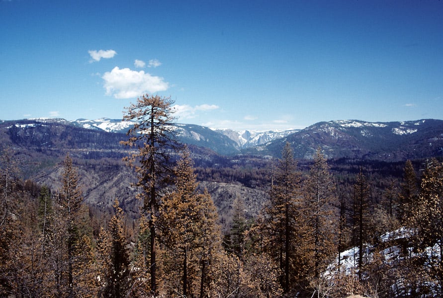
I didn’t know that there are fewer individual and less severe wildfires in the early season, due to snowpack’s effect on thunderstorm development. The Forest Service land, where I took this 1990 picture of the A-Rock Fire, has burned 13 times in the last 100 years. Why did this particular wildfire kill so much old growth, when previous uncontrolled fires did not?

A-Rock3-web

You can also see the fire’s “twin”, across the canyon. It also has suffered a re-burn, although it was the Park Service who let a fire get out of hand, on that incident too. The A-Rock re-burned when a prescribed fire was lit, and lost, within an hour of ignition. The Meadow Fire burned for weeks, costing $17 million, closing the Park during the height of tourist season. The Forest Service portion of the A-Rock Fire hasn’t re-burned, yet.

How to Cover a Western Wildfire

Some levity is always good on this blog, especially before a big weekend. Thanks to a reader for sending this in. Couldn’t find any photos of

One of the most important things is how you dress. The men must wear smoked yellow Nomex shirts and stop shaving the moment they are sent to the fire. They must not shave their faces or wash their Nomex until they are done covering the fire, even if they sleep at home every night. Nomex, like hockey pads, should never be washed during the life of the man or the equipment.

Women must keep their Nomex a spotless bright yellow. All hair and makeup must be perfect.

but can post any someone sends in.

Below is an excerpt:

It is acceptable to use the word “firefighters” when referring to them in ones and twos, but in large numbers they should be referred to as “resources,” as should bulldozers, aircraft and fire trucks. Therefore, when interviewing a fire commander you ask, “Do you have enough resources?” He will tell you he does not. If you find yourself overusing “resources” then substitute “assets.”

Never refer to anything that grows in the path of fire as grass, a bush or a tree. It is known as “fuel.” Dense growth is to be referred to as “fuel beds.” It is acceptable to refer to foliage as “brush,” but all brush is “tinder dry.” (See “Deficit, Federal”)

The massive inferno never burns natural terrain or unoccupied wilderness. Wildfire does not burn trailer homes or mere houses. It burns primarily “multi-million dollar homes.” The blaze never burns a barn, a tool shack or a secluded meth lab. It “incinerates outbuildings.” Don’t cover a wildfire that burns only trees, unless someone in a position of authority describes them as a “precious natural resource.”

In general, when wildfire is not burning multi-million dollar homes it burns only “structures.” When fire comes close to houses or barns, it is a “structure threat.” Fire trucks parked in a suburban loop are performing “structure protection,” but there’s nothing to worry about because they have plenty of resources in the area.

Flames do not have height, they have “length” even when they shoot 100 feet straight in the air. So you might be told by a fire commander that, “We’re seeing flame lengths of 150 feet or more.”

Hanson: The Ecological Importance of California’s Rim Fire

The following article, written by Dr. Chad Hanson, appeared yesterday at the Earth Island Journal. Once again, I’d like to respectfully request that if anyone has questions about the content of the article please contact Dr. Hanson directly. Thanks. – mk

The Ecological Importance of California’s Rim Fire: Large, intense fires have always been a natural part of fire regimes in Sierra Nevada forests
by Chad Hanson – August 28, 2013

Since the Rim fire began in the central Sierra Nevada on August 17, there has been a steady stream of fearful, hyperbolic, and misinformed reporting in much of the media. The fire, which is currently 188,000 acres in size and covers portions of the Stanislaus National Forest and the northwestern corner of Yosemite National Park, has been consistently described as “catastrophic”, “destructive”, and “devastating.” One story featured a quote from a local man who said he expected “nothing to be left”. However, if we can, for a moment, set aside the fear, the panic, and the decades of misunderstanding about wildland fires in our forests, it turns out that the facts differ dramatically from the popular misconceptions. The Rim fire is a good thing for the health of the forest ecosystem. It is not devastation, or loss. It is ecological restoration.

What relatively few people in the general public understand at present is that large, intense fires have always been a natural part of fire regimes in Sierra Nevada forests. Patches of high-intensity fire, wherein most or all trees are killed, creates “snag forest habitat,” which is the rarest, and one of the most ecologically important, forest habitat types in the entire Sierra Nevada. Contrary to common myths, even when forest fires burn hottest, only a tiny proportion of the aboveground biomass is actually consumed (typically less than 3 percent). Habitat is not lost. Far from it. Instead, mature forest is transformed into “snag forest”, which is abundant in standing fire-killed trees, or “snags,” patches of native fire-following shrubs, downed logs, colorful flowers, and dense pockets of natural conifer regeneration.

This forest rejuvenation begins in the first spring after the fire. Native wood-boring beetles rapidly colonize burn areas, detecting the fires from dozens of miles away through infrared receptors that these species have evolved over millennia, in a long relationship with fire. The beetles bore under the bark of standing snags and lay their eggs, and the larvae feed and develop there. Woodpecker species, such as the rare and imperiled black-backed woodpecker (currently proposed for listing under the Endangered Species Act), depend upon snag forest habitat and wood-boring beetles for survival.

One black-backed woodpecker eats about 13,500 beetle larvae every year — and that generally requires at least 100 to 200 standing dead trees per acre. Black-backed woodpeckers, which are naturally camouflaged against the charred bark of a fire-killed tree, are a keystone species, and they excavate a new nest cavity every year, even when they stay in the same territory. This creates homes for numerous secondary cavity-nesting species, like the mountain bluebird (and, occasionally, squirrels and even martens), that cannot excavate their own nest cavities. The native flowering shrubs that germinate after fire attract many species of flying insects, which provide food for flycatchers and bats; and the shrubs, new conifer growth, and downed logs provide excellent habitat for small mammals. This, in turn, attracts raptors, like the California spotted owl and northern goshawk, which nest and roost mainly in the low/moderate-intensity fire areas, or in adjacent unburned forest, but actively forage in the snag forest habitat patches created by high-intensity fire — a sort of “bedroom and kitchen” effect. Deer thrive on the new growth, black bears forage happily on the rich source of berries, grubs, and small mammals in snag forest habitat, and even rare carnivores like the Pacific fisher actively hunt for small mammals in this post-fire habitat.

In fact, every scientific study that has been conducted in large, intense fires in the Sierra Nevada has found that the big patches of snag forest habitat support levels of native biodiversity and total wildlife abundance that are equal to or (in most cases) higher than old-growth forest. This has been found in the Donner fire of 1960, the Manter and Storrie fires of 2000, the McNally fire of 2002, and the Moonlight fire of 2007, to name a few. Wildlife abundance in snag forest increases up to about 25 or 30 years after fire, and then declines as snag forest is replaced by a new stand of forest (increasing again, several decades later, after the new stand becomes old forest). The woodpeckers, like the black-backed woodpecker, thrive for 7 to 10 years after fire generally, and then must move on to find a new fire, as their beetle larvae prey begins to dwindle. Flycatchers and other birds increase after 10 years post-fire, and continue to increase for another two decades. Thus, snag forest habitat is ephemeral, and native biodiversity in the Sierra Nevada depends upon a constantly replenished supply of new fires.

It would surprise most people to learn that snag forest habitat is far rarer in the Sierra Nevada than old-growth forest. There are about 1.2 million acres of old-growth forest in the Sierra, but less than 400,000 acres of snag forest habitat, even after including the Rim fire to date. This is due to fire suppression, which has, over decades, substantially reduced the average annual amount of high-intensity fire relative to historic levels, according to multiple studies. Because of this, and the combined impact of extensive post-fire commercial logging on national forest lands and private lands, we have far less snag forest habitat now than we had in the early twentieth century, and before. This has put numerous wildlife species at risk. These are species that have evolved to depend upon the many habitat features in snag forest — habitat that cannot be created by any other means. Further, high-intensity fire is not increasing currently, according to most studies (and contrary to widespread assumptions), and our forests are getting wetter, not drier (according to every study that has empirically investigated this question), so we cannot afford to be cavalier and assume that there will be more fire in the future, despite fire suppression efforts. We will need to purposefully allow more fires to burn, especially in the more remote forests.

The black-backed woodpecker, for example, has been reduced to a mere several hundred pairs in the Sierra Nevada due to fire suppression, post-fire logging, and commercial thinning of forests, creating a significant risk of future extinction unless forest management policies change, and unless forest plans on our national forests include protections (which they currently do not). This species is a “management indicator species”, or bellwether, for the entire group of species associated with snag forest habitat. As the black-backed woodpecker goes, so too do many other species, including some that we probably don’t yet know are in trouble. The Rim fire has created valuable snag forest habitat in the area in which it was needed most in the Sierra Nevada: the western slope of the central portion of the range. Even the Forest Service’s own scientists have acknowledged that the levels of high-intensity fire in this area are unnaturally low, and need to be increased. In fact, the last moderately significant fires in this area occurred about a decade ago, and there was a substantial risk that a 200-mile gap in black-backed woodpeckers populations was about to develop, which is not a good sign from a conservation biology standpoint. The Rim fire has helped this situation, but we still have far too little snag forest habitat in the Sierra Nevada, and no protections from the ecological devastation of post-fire logging.

Recent scientific studies have caused scientists to substantially revise previous assumptions about historic fire regimes and forest structure. We now know that Sierra Nevada forests, including ponderosa pine and mixed-conifer forests, were not homogenously “open and parklike” with only low-intensity fire. Instead, many lines of evidence, and many published studies, show that these areas were often very dense, and were dominated by mixed-intensity fire, with high-intensity fire proportions ranging generally from 15 percent to more than 50 percent, depending upon the fire and area. Numerous historic sources, and reconstructions, document that large high-intensity fire patches did in fact occur prior to fire suppression and logging. Often these patches were hundreds of acres in size, and occasionally they were thousands — even tens of thousands — of acres. So, there is no ecological reason to fear or lament fires like the Rim fire, especially in an era of ongoing fire deficit.

Most fires, of course, are much smaller, and less intense than the Rim fire, including the other fires occurring this year. Over the past quarter-century fires in the Sierra Nevada have been dominated on average by low/moderate-intensity effects, including in the areas that have not burned in several decades. But, after decades of fear-inducing, taxpayer-subsidized, anti-fire propaganda from the US Forest Service, it is relatively easier for many to accept smaller, less intense fires, and more challenging to appreciate big fires like the Rim fire. However, if we are to manage forests for ecological integrity, and maintain the full range of native wildlife species on the landscape, it is a challenge that we must embrace.

Encouragingly, the previous assumption about a tension between the restoration of more fire in our forests and home protection has proven to be false. Every study that has investigated this issue has found that the only way to effectively protect homes is to reduce combustible brush in “defensible space” within 100 to 200 feet of individual homes. Current forest management policy on national forest lands, unfortunately, remains heavily focused not only on suppressing fires in remote wildlands far from homes, but also on intensive mechanical “thinning” projects — which typically involve the commercial removal of upwards of 80 percent of the trees, including mature trees and often old-growth trees —that are mostly a long distance from homes. This not only diverts scarce resources away from home protection, but also gives homeowners a false sense of security because a federal agency has implied, incorrectly, that they are now protected from fire — a context that puts homes further at risk.

The new scientific data is telling us that we need not fear fire in our forests. Fire is doing important and beneficial ecological work, and we need more of it, including the occasional large, intense fires. Nor do we need to balance home protection with the restoration of fire’s role in our forests. The two are not in conflict. We do, however, need to muster the courage to transcend our fears and outdated assumptions about fire. Our forest ecosystems will be better for it.

Chad Hanson, the director of the John Muir Project (JMP) of Earth Island Institute, has a Ph.D. in ecology from the University of California at Davis, and focuses his research on forest and fire ecology in the Sierra Nevada. He can be reached at [email protected], or visit JMP’s website at www.johnmuirproject.org for more information, and for citations to specific studies pertaining to the points made in this article.
2013 Fire Season in New Mexico Below Normal: Nearly 60% of forest land within fire boundaries remained unburned or burned at low severity

The following press release is from WildEarth Guardians. If you click on this link, you can see a few charts and a map. If anyone has questions about the information contained within this press release from WildEarth Guardians, please contact WildEarth Guardians directly. Thank you. – mk

2013 Fire Season in New Mexico Below Normal:
Nearly 60% of forest land within fire boundaries remained unburned or burned at low severity

Contact: Bryan Bird (505) 699-4719

Santa Fe – New Mexico experienced several expensive fires early this summer, the largest was the Silver Fire covering nearly 217 square miles in the Black Range. Fire costs in the U.S. have topped $1 billion so far this year; less than last year’s $1.9 billion, but the fire season is not over. The Thompson Ridge fire alone cost $16,326,136 before it was declared contained. Rising plumes of smoke could be seen on the horizon of Santa Fe and Albuquerque and breathless reporters gave statistics of ever increasing acreages of devastated forestland.

But, the numbers tell a different story. The four major fires in New Mexico this summer covered a total of 184,024 acres or nearly 288 square miles, but just 16% of that area burned at high severity. In all 213,289 acres have burned to date in New Mexico. While there is still a chance for late season fires, the total burned area for 2013 is significantly less than the 372,497 acres burned in 2012.

“Once the smoke cleared, the environmental benefits of the 2013 fire season were obvious,” Said Bryan Bird, Wild Places Director for WildEarth Guardians. “Though flooding is always a risk, these fires do more to clear fuels and reduce fire hazard than we could do with mechanical treatments and a large chunk of the federal budget.”

Burn Area Emergency Response (BAER) teams take action immediately after fires to analyze the area within the burn perimeter and take action to minimize immediate damage from flooding, which can have severe consequences downstream. The BAER teams measure fire severity to analyze the loss of organic matter from the forest. In areas of low fire severity ground litter is charred or consumed, but tree canopies remain mostly unburned and the top layer of soil organic matter remains unharmed. Areas of moderate severity have a higher percentage of both crown and soil organic matter consumed. Areas of high severity have lost all or most of tree canopy organic matter and soil organic matter is wholly consumed.

The numbers reported by the BAER teams for the 2013 fire season in New Mexico put into perspective the burn results. Of all acres within fire boundaries over 10,000 acres this summer, 59% (109,290 acres) were ranked as unburned or low severity. Another 24% (44,880 acres) was moderate severity. Finally, just 16% (29,125 acres) burned at high severity.

The Joroso Fire, located in the Pecos Wilderness, burned primarily in mature Spruce Fir stands with high levels of wind blown material. These conditions create an environment where high severity burns are much more likely than the other fires, so it is instructive to remove it from summary statistics. When removing this fire from the analysis the overall numbers demonstrate even less severe effects on the vegetation: 61% remained unburned or burned at low intensity, 25% burned at moderate severity, and only 13% burned at high severity.

Fire fighting in the United Sates has become a very costly endeavor. While most fires are extinguished quickly, it is the very small portion of wildfires that are not immediately controlled and result in significant financial burdens to states and the federal government. Already this year the Forest Service has exhausted its fire-fighting budget and has had to tap other budget line items. And yet, it is not clear that committing such resources is necessary or beneficial when human life and property are not immediately at risk.

“Fire is an essential process in western forests and we cannot eliminate it. Resources need to be reserved for protecting lives, not supporting huge operations in the backcountry.” Said Bird. “We can fire proof communities, but we cannot fire proof the forest.”

Blame For Western Wildfires… Timber Industry (??!!)

I just read this story from AP via NPR.. interesting statement by “Federal forest ecologists.” I wish they’d said “some federal forest ecologists” or even “one or two”, whomever they interviewed.

Federal forest ecologists say that historic policies of fire suppression to protect Sierra timber interests left a century’s worth of fuel in the fire’s path.

“That’s called making the woodpile bigger,” said Hugh Safford, an ecologist with the U.S. Forest Service in California.

Wow! My first experience in the Sierra was at Meadow Valley Forestry Camp, prior to UC Berkeley forestry school in 1974. That was almost 40 years ago. At that time there were many people and communities, (camps, ski areas, etc.) and infrastructure of various kinds (dams, powerlines) in the Sierra. Fires were thought to be bad for people and communities and infrastructure. Smoke was bad for human health.

It seems to me that fires were also suppressed, and continue to be suppressed, in southern California, where there was no timber and no timber industry, but there was still.. people and houses and infrastructure. And Colorado, where industry is minimal…

Wilderness Watch Questions Landscaping Proposal for the Pasayten Wilderness

From Wilderness Watch:

Wilderness Watch is urging the Forest Service (FS) to abandon its proposal to plant whitebark pine in the Pasayten Wilderness in Washington. None of the reasons the FS gives in its Quartz Mountain Whitebark Pine Preliminary Environmental Assessment (EA) appear to be valid. The EA states, “There is a need to establish a whitebark pine seed source…for natural regeneration to occur.” It also notes, “…no tree seedlings were observed on the former whitebark site and it is therefore unlikely that whitebark pine will naturally regenerate in the area.” This clearly leads the public to believe there are no living whitebark pines in the area. However, the EA goes on to contradict the earlier statement by saying there are “surviving whitebark pines in the Quartz Mountain area.”

The Quartz Mountain fire that killed whitebark pines was a natural event, and it may take decades for seedlings to be reestablished (a fact recognized by the Whitebark Pine Foundation). The project would have a significant negative impact on the Pasayten Wilderness. Wilderness Watch told the Forest Service to let natural processes—fire, Clark’s nutcrackers, rains, and wind—determine the extent of whitebark pine regeneration. Wilderness is about wildness and that includes letting nature determine when and where seedlings will be re-established. Any experiment of this type should be confined to non-Wilderness lands.

Read Wilderness Watch’s comments here.

Stanley Idaho Turns North for Ideas on Wildfire Protectionto

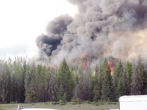
 The black smoke signals a particularly hot area in a prescribed burn in British Columbia’s Kootenay National Park in 2008, when trees killed by mountain pine beetles were on the ground. Idaho’s Sawtooths have similar lodgepole pine forests. PROVIDED BY PARKS CANADA — Provided by Parks Canada

The black smoke signals a particularly hot area in a prescribed burn in British Columbia’s Kootenay National Park in 2008, when trees killed by mountain pine beetles were on the ground. Idaho’s Sawtooths have similar lodgepole pine forests.
PROVIDED BY PARKS CANADA — Provided by Parks Canada

Does anyone know any philanthropists? I propose an NCFP field trip to Kootenay National Park.

Here’s a link to a story by Rocky Barker in June.

A CANADIAN MODEL

The Forest Service burns thousands of acres of ponderosa pine in prescriptive burns, but very little lodgepole. But Stanley leaders have looked to Canada for a late-winter, early-spring model for burning lodgepole, and they hope the Forest Service will consider it.

Most of Southern Idaho forests have burned over the past 25 years. With those forests cleared of built-up fuels, firefighters have made steering new fires into those previously burned tracts their main tactic.

But the heart of the Sawtooth Valley remains largely untouched over the same period.

“What remains to burn is right in front of us,” said Herbert Mumford, mayor of Stanley, which has 63 year-round residents.

There is only one power line connecting the mountain hamlet to the grid that snakes up the Salmon River from Challis. If a fire burns through the line, Salmon River Electrical Cooperative officials tell Mumford, it could take weeks to rebuild it.

No electricity would mean the sewage treatment plant would stop working, Mumford said, leaving the community helpless. That’s why he and Steve Botti, president of the City Council, are leading the effort to seek a more aggressive prescriptive-burning effort.

“Should we just sit back and buy marshmallows and weenies and wait for the fire to start?” Mumford said.

Botti, a retired National Park Service fire ecologist at Boise’s National Interagency Fire Center, was familiar with Parks Canada’s ambitious burning program in lodgepole pine forests in British Columbia and Alberta. Two of the program’s leaders came to Stanley this spring to tell of their success.

A MATTER OF TIME

In Kootenay National Park, about two hours west of Calgary, Parks Canada embarked on a landscape-level program designed to burn strategic chunks of forest under carefully managed conditions. The burning is done during spring or late fall. Loggers cut large open spaces, or “anchors,” to ensure that the fire stays within its parameters and to protect revenue-producing forests nearby.

The logging is done in winter, to reduce impact on the land and the park’s visitor season.

“It is understood as a sacrifice on national park land” to prevent future fires and improve the larger ecology, said Rick Kubian, resource conservation manager for Lake Louise, Yoho and Kootenay parks.

The fires have been successful. They burn the identified areas in a mosaic pattern, which will slow down any future fire that tests the forest. It’s the kind of burning that Stanley leaders hope they can convince the Forest Service to try in Idaho.

Sawtooth National Ran-ger Joby Timm is pleased that Stanley has put together the fire collaborative and is encouraged by its support for increased management. He proudly points to the agency’s record of preventive “treatment” of 90 percent of the recreation area’s wildland-urban interface.

He and the Forest Service’s local fire managers support what the Canadians have done, but Timm is skeptical that large Canada-style winter burns, along with the necessary logging, could get the support needed from Idahoans who want their scenic views unchanged.

“Politically and socially,” Timm said, “I don’t know how logging a quarter-mile swath would be accepted in the Sawtooths.”

Forsgren, Mumford and Botti all say that it’s just a matter of time until the Sawtooth Valley burns. Those who want to see it left alone could see the view they love blackened and an entire summer recreation season lost.

The next step is for the collaborative group to make a formal proposal to the Forest Service.

“Fire is part of the ecosystem, but we don’t want it all to burn,” Forsgren said. “We’d like the Forest Service to do some logging and prescribed burning so when the fire comes, it drops to the ground, where they can fight it.”

Read more here: http://www.idahostatesman.com/2013/06/02/2599958/protecting-stanley-from-wildfires.html#storylink=cpy

People Like Trees: Protecting Giant Sequoia

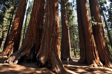
Sequoia National Park, California.

There are a many things I like about this story: it talks about communities, and not homes.

Hundreds of firefighters were deployed Sunday to protect Tuolumne City and other communities in the path of the Rim Fire. Eight fire trucks and four bulldozers were deployed near Bunney’s ranch on the west side of Mount Baldy, where two years of drought have created tinder-dry conditions.

It also talks about infrastructure

Despite ash falling like snowflakes on the reservoir and a thick haze of smoke limiting visibility to 100 feet, the quality of the water piped to the city 150 miles away is still good, say officials with the San Francisco Public Utilities Commission.

The city’s hydroelectric power generated by the system has been interrupted by the fire, forcing the utility to spend $600,000 buying power on the open market.

And measures needed to keep fires out of communities

Fire lines near Ponderosa Hills and Twain Hart are being cut miles ahead of the blaze in locations where fire officials hope they will help protect the communities should the fire jump containment lines.

“There is a huge focus in those areas in terms of air support and crews on the ground building fire lines to protect those communities. We’re facing difficult conditions and extremely challenging weather,” Frederickson said.

And of course people at the end of the day are not wrapped around a philosophical question of “natural” fires and whether fires can every be “natural” with past fire suppression and climate change, they are simply protecting valued trees, even though those trees are adapted to fire.

Values seem like a straightforward way to manage; replicating the past, not so much (like impossible, really). IMHO.

Park employees are continuing their efforts to protect two groves of giant sequoias that are unique the region by cutting brush and setting sprinklers, Medena said.

and in this story:

The iconic trees can resist fire, but dry conditions and heavy brush are forcing park officials to take extra precautions in the Tuolumne and Merced groves. About three dozen of the giant trees are affected.

“All of the plants and trees in Yosemite are important, but the giant sequoias are incredibly important both for what they are and as symbols of the National Park System,” park spokesman Scott Gediman said Saturday.

Rangers tread tricky path when deciding to let fires burn

I think this story is interesting because it talks about the real world of what happens with deciding on suppression strategies..remember, we had a discussion about the Hubbard letter..in this and previous linked posts.

Here
is the link and below is an excerpt..interestingly, the Durango Herald interviewed someone who actually explained how he is making decisions. Apparently, making a phone call from Monte Vista to Golden is not all that difficult.

Often, the crew that first responds to a lightning strike will decide on the spot to put the fire out. But if the fire is too remote to reach, or there are too many little fires burning at the same time, decisions get kicked up the chain of command to a duty officer, the district ranger or the forest supervisor.

“I can’t give you a cookbook-type answer. There’s discretion. There’s professional judgment,” said Dan Dallas, supervisor of the Rio Grande National Forest.

Each national forest develops fire-management plans in advance to identify swaths of land where a fire would be welcome. But Forest Service officers also have to look at the weather and the availability of crews to monitor a fire.

The conditions aligned for Dallas this summer on the Ox Cart Fire, a blaze he wanted to let burn for resource benefits. He got permission from Regional Forester Dan Jirón in Golden, the senior Forest Service officer in a five-state area.

Until last year, Dallas would have had the authority to make the call himself, as the forest supervisor.

But in May 2012, James Hubbard, deputy chief of the Forest Service, declared that only regional foresters could approve managing a fire for resource benefits, instead of putting it out as fast as possible.

“I acknowledge this is not a desirable approach in the long-run,” Hubbard wrote in his memo.

Forest Service Chief Tom Tidwell somewhat softened that policy this February in his “letter of intent” for the 2013 fire season, but he still warned that officers who want to let a fire burn will be held to the strictest performance standards.

Dallas got permission to let the Ox Cart Fire smolder on the western slopes of the Sangre de Cristo Mountains, south of Salida.

Mike Blakeman, the spokesman for Rio Grande National Forest, spent several days in Salida talking about the blaze and the smoke it was emitting.

“It sat there for three, almost four weeks and didn’t grow significantly,” Dallas said.

Then one afternoon, it blew up a bowl on the mountain and burned 1,000 acres.

He would have preferred to let it go some more, but the big burn happened at the same time as the West Fork Complex blowup, which sent up a smoke column that was visible from Denver.

With the eyes of the country fixed on his forest, Dallas decided to put out the fire.

When fires get big enough, local foresters will call in an incident management team and delegate authority for the blaze. That’s what Dallas did with the Ox Cart Fire.

The incident team had the fire under control in five days.

Air Tanker Video

I’m away from home now but, I just had to post this VERY interesting video of a military plane making a retardant drop on the Rim Fire. I think the radio conversation is with the lead plane. What an exciting job!!

http://www.youtube.com/watch?v=c_eGiGG1B-Q

There are also several other videos of this plane on You Tube.

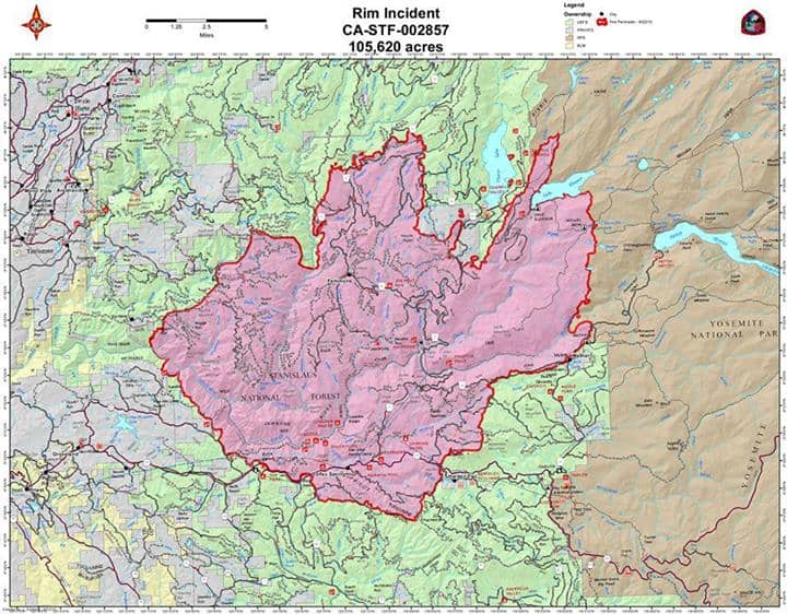
On a side note, I was still able to see the column over 100 miles away, from the city of Pleasanton, on Interstate 680. The smoke at my house this morning was so thick there was only 1/4 mile visibility, and the fire is about 40 miles away. The old burn perimeters haven’t even slowed down the fire, re-burning in at least 4 older burns. It’s looking REAL bad, with just 2% containment of a 105,000 acre fire.

Rim Fire