How Many Snags Do Birds Need??

With our discussions about burned forests and blackbacked woodpeckers, here are some views of the Power Fire, on the Eldorado National Forest. Initially, the wildfire seemed to be of mixed severity but, as the summer wore on, more and more insect mortality caused previously green trees to turn brown. After Chad Hanson took his appeal to the Ninth Circuit Court, this project was halted with about 75% of the dead trees cut. The court decided that not enough analysis was done regarding the blackbacked woodpecker, despite only 55% of the burned area in the project.

In this picture, seven years after it burned, most of those foreground snags were in a helicopter unit, with a fairly large stream buffer at the bottom. At least 5 times we marked additional mortality in that unit. Also important is the fact that we were cutting trees which still had green needles, using the new fire mortality guidelines of the time. As you can see, the density of snags should be quite sufficient in supporting multiple woodpecker families.

P9256073-web

This patch of snags was clumped, below a main road and above a major streamcourse.

P9256059-web

Another view of abundant snags within a cutting unit, and a protected streamcourse.

P9256069-web

You can see that both large and small snags were left for wildlife. After 6 years, surely some snags have already fallen, as expected. Not every acre can, or should, have birds on every acre. Since this is predominantly a P. pine stand, the combination of high-intensity fire and subsequent bark beetles caused catastrophic losses of owl and goshawk habitat, including nest trees. You can also see that reforestation is, and will continue to be problematic, with all that deerbrush coming back so thick.

P9256064-web

Good fire, bad fire: the myth of the mega-blaze

Brooks Hays, a reporter with GIMBY, recently wrote an article that should generate some interest here, especially in context of some of the comments related to recent black-backed woodpecker articles.  Below is a snip from the opening lead, which features some quotes from forest ecologist Chad Hanson.  The article also includes perspectives from Richard Hutto, forest ecologist and director of the Avian Science Center at the University of Montana, and from myself.  You can read the entire article here.

Last summer, talk of wildfires filled newspapers and dominated the headlines. Wildfires were “trending,” as they say.

Blazes were burning the western forests in record numbers, announced policy officials and reporters. Every news and science organization from USA Today to the National Oceanic and Atmospheric Administration (NOAA) was calling 2012’s fire season one of the worst on record.

“Records maintained by the National Interagency Fire Center (NIFC) and NASA both indicate that 2012 was an extraordinary year for wildfires in the United States,” NOAA wrote in a year-end review.

Weather Underground co-founder Jeff Masters blamed the growing threat of wildfire on “rising temperatures and earlier snow melt due to climate change” and added that “fire suppression policies which leave more timber to burn may also be a factor.”

In August, as fire season continued to rage in most of the West, National Public Radio ran a five-part series calling mega-fires the “new normal.” This new reality was attributed to excess forest growth — an overly abundant accumulation of combustible materials – all resulting from an overzealous Forest Service that put out too many fires. NPR dubbed it the “Smokey the Bear effect.”

But a growing body of empirical data suggests these superlatives might be more storytelling than science. “Those terms, ‘mega-fire’ and ‘catastrophic fire,’ are not scientific terms,” says forest ecologist Chad Hanson, executive director of the John Muir Project. “And such hyperbolic and extreme terms are not going to lead us to an objective view of the evidence.”

An objective view of the evidence, Hanson argues, reveals that the vast majority of wildlands and forests aren’t burning hotter and faster.  They’re actually starved for high-intensity fires — fires Hanson says are more ecologically valuable than they’re given credit for.

As Hanson argues in his most recent study, The Myth of “Catastrophic” Wildfire, high-intensity fires are the exception in the U.S. today, not the norm. And he finds no correlation between increased fire-suppression activity and high-intensity fire. Hanson says the opposite is true: the longer a forest goes without fire, the more mature it becomes, the higher its canopy grows, and the less susceptible it is to fire damage.

Click here to read the entire article.

More Fires and Less Burned Snag Habitat: How Can Both Be True?

Oregon_amo_2011239NASA photo

Certainly this story is about Colorado and neither Oregon nor South Dakota; still, it makes a person wonder.

Here’s the link and below is an excerpt.

If wildlife acres burned double in the next 50 years, how can birds that live in burnt trees be on a bad trajectory in terms of habitat? Could someone in the legal business explain the logic path.. facts found, conclusions drawn, how that relates to the ESA regulations to make the FWS go spend bucks (I wonder if they track how many?) to assess this situation when Interior can’t afford to plow the roads to Yellowstone Park?

The hotter, drier climate will transform Rocky Mountain forests, unleashing wider wildfires and insect attacks, federal scientists warn in a report for Congress and the White House.

The U.S. Forest Service scientists project that, by 2050, the area burned each year by increasingly severe wildfires will at least double, to around 20 million acres nationwide.

Some regions, including western Colorado, are expected to face up to a fivefold increase in acres burned if climate change continues on the current trajectory.

Floods, droughts and heat waves, driven by changing weather patterns, also are expected to spur bug infestations of the sort seen across 4 million acres of Colorado pine forests.

“We’re going to have to figure out some more effective and efficient ways for adapting rather than just pouring more and more resources and money at it,” Forest Service climate change advisor Dave Cleaves said.

“We’re going to have to have a lot more partnerships with states and communities to look at fires and forest health problems.”

The Forest Service scientists this week attended a “National Adaptation” forum in Denver, where experts explored responses to climate change. They’ve synthesized 25 years of federal climate science as part of the National Climate Assessment — now being finalized for the president and Congress — as the basis for navigating changes.

Degradation of city watersheds is anticipated along with diminished cleansing capacity of forests. Forests today absorb an estimated 13 percent of U.S. carbon pollution.

New data shows bug attacks are already broadening. In Colorado, insects target trees at higher elevations, such as white-bark pines found in wilderness areas, said David Peterson, a Forest Service research biologist who co-wrote the 265-page report.

This was also interesting..

Some Western governors took the climate change warning as confirmation of current trends and called for federal help creating new forest projects industries.

Fires and insect attacks “are only going to get even worse,” Montana Gov. Steve Bullock said Wednesday. “We need a real federal commitment to managing our forests in a way that will prepare and protect our communities, protect and enhance wildlife habitat and protect our water for drinking, irrigation and fishing.”

IRR Program a Success, Says USFS

Received this press release this morning. I’m not familiar with the “Integrated Resource Restoration Program.” Has the agency “exceeded or met its goals in almost every performance category”?

http://www.fs.fed.us/restoration/IRR/index.shtml

Forest Service pilot restoration program improved 800,000 acres of forest in 2012
WASHINGTON, April 8, 2013 — A major U.S. Forest Service pilot program treated some 800,000 acres of federal forestland to help protect them from catastrophic wildfire in 2012, and improved the condition of three major watersheds in the interior West.
The Integrated Resource Restoration program exceeded or met its goals in almost every performance category, decommissioning 738 miles of roads, enhancing 933 miles of stream habitat and resulting in the sale of more than 850,000 cubic board feet of timber.
“Integrated Resource Restoration allows us to be more efficient and strategic in how we manage our forests and grasslands,” said U.S. Forest Service Chief Tom Tidwell.  “We see this program as a model for good management.”
Under the program, landscape-level projects that would otherwise be piecemealed together over many years were funded in a single year with a single budget, providing program managers the flexibility to prioritize restoration projects.
This prioritization simplified budget planning and eased the identification of goals and priorities. Program managers, instead of competing for individual program funds to pay for specific projects, are now looking for opportunities to integrate multiple restoration projects and priorities. The Integrated Resource Restoration program fits into the larger nation-wide restoration work of the U.S. Forest Service, which led the restoration of more than 4 million acres of forestland in 2012.
The improvement of watersheds will continue to be a priority for the agency. In a report issued in January, Forest Service researchers predicted that water resources will grow scarcer in coming decades – especially in the western states – as pressures such as climate change, encroachment and increased demand continue to impact the nation’s forests.
The Integrated Resource Restoration program improved the condition of the Pass Creek watershed on the Gallatin National Forest in Montana, the Waw’ aalamnime Creek watershed on the Clearwater National Forest in Idaho, and the Bull Creek watershed on the Boise National Forest, also in Idaho.

When a Preservationist Joins a Collaborative Group

Without making any value judgements here, I find this collection of meeting summaries to be fascinating. Chad Hanson is a full member of the Dinkey Collaborative Group, working to create a better future for the Sierra National Forest. It will be very interesting to see how this process will evolve, with Hanson’s input solidly in view. The level of transparency seems acceptable to me.  At the same time, The Sierra is using the new Planning Rule to update their Forest Plan.

Doug-fir-powers-web

Mr. Hanson noted that there was no option for opposing the proposal, and also stated his concern for his opposition going undocumented. Mr. Hanson expressed two main concerns with the proposal. He stated that the proposal assumed high intensity fire results in fisher habitat loss, and commented that the proposal states an inaccurate assumption that trees experience almost complete mortality when a fire burns. Mr. Hanson expressed that the mortality rate was not supported by current data. Mr. Dorian Fougères assured Mr. Hanson that his position would be documented.

Click to access stelprdb5364086.pdf

There are other meeting notes available by searching for “Dinkey Collaborative Hanson”.

Fire Resilient Communities: Waldo Fire Report

From Inciweb Waldo Canyon Fire - June 26thCredit: Adam Drake
From Inciweb Waldo Canyon Fire – June 26th
Credit: Adam Drake

Imagining a positive mutual future for wildland urban interface areas…check out this video about how Colorado Springs worked to create a Fire Resilient community, and their experience with the Waldo Canyon Fire. If you haven’t been around a western more or less urban community experiencing fire, listening to some of the interviews may give you a look at what it feels like to folks who live there.

Also, at about 4:30 in the video, Brett Lacy, the Fire Marshall of the Colorado Springs Fire Department, says “we expected the fire to go to those mitigation areas and lay down, but in most instances it hit those areas and went out,” and shows a couple of areas. Looks like those areas are beyond the home ignition zone. We have discussed these kinds of things on the blog before, but I think this video is helpful in seeing the areas treated and how that affected fire behavior.

You might also want to check out other information on the Fire Adapted Communities website here.

Group sues to stop Hebgen timber sale

Pages from lonesome wood rod

Another Montana project.. above is the map. You can click on it to get greater detail.

Here’s a link to a news story, below is an excerpt.

The area covered by the timber sale is along the western and southern shores of Hebgen Lake. The Forest Service initiated the project, saying logging would safeguard area cabins from wildfires.

But Mike Garrity of the Alliance for the Wild Rockies said some of the proposed logging is in roadless areas away from the cabins. The Forest Service would build six miles of logging roads and log 400 acres of designated old growth forest.

Both groups claim the old growth areas are habitat for lynx, grizzly bears and wolverines, all of which are rare. The Forest Service and the U.S. Fish and Wildlife Service both determined in an assessment that logging would adversely affect grizzlies and lynx.
Garrity said the groups don’t oppose all the logging in that area, just the old growth sections.
“Their own fire expert says to start at the structures and work out, clearing the trees to create a defensible space, and they’re not doing that,” Garrity said.
This isn’t the first challenge for this area. The Forest Service proposed a similar sale but dropped the sale after Alliance for the Wild Rockies sued in 2009.
Garrity said the Forest Service loses money on timber sales, because it is usually unable to get enough money for the logs to cover its costs.
“Right now, when the government is authorizing less spending with the sequester, timber sales cost the taxpayer,” Garrity said.

In a couple of seconds, I was able to find this handy ROD. It’s in a pdf so you can search for old growth. You can look at the map and see how far the units are from private land (not very).. “roadless areas”?. But it would be handy to have the overlay of the units on Googlemaps.

Vegetation – Old Growth Protection
45. Old growth stands in Compartment 709 will be avoided during unit layout. Unit boundaries for unit 17, 20, 25, 26C, 26B and 26A will avoid adjacent old growth stands 70907006 (unit 17), 70907029 (unit 20), 70906036 (unit 25/26c), 70904036 (units 26a/26b). These avoidances will require inspection of preliminary unit boundaries on the ground to ensure old growth stands are avoided.

I’m sure it is more complex than it appears from this glance, but that is what I’d expect a story to get at .. if Garrity says they are far away and going into old growth, what does the FS have to say?

Note for retirees and other local folks Even if the FS can’t share their perspective due to the litigation cone of silence, you can learn about the project and be available to the media. You can be spokespeople for CREATE. Part of CREATE’s mission is to ensure that good information is given to the public about projects. This is one “direct action” approach.

Trail maintenance and fire suppression also cost the taxpayer, so I’m not sure exactly what Garrity’s point is there.

Sharon’s review of document:
I think the ROD is convenient to use, and generally excellent with all the information you need to find right there. Would also like to see more photos and the units on Google maps. Maybe they are located somewhere else. A- Nice work!

Sharon’s review of news story:
Did not even superficially examine Garrity’s claims. D

Chief on Fire Policy

I found this on the FS Twitter feed…

The federal wildland fire policy has not changed since 1995. Neither the direction issued last year nor my letter this year represented a shift in Forest Service policy for fighting fires. We always look at the conditions that exist around each fire season, our available resources, and then provide guidance to the field. It takes resources to suppress fires, and to manage them for resource benefits. We do have a set amount of expertise in this country but when we get a wildfire season like we did last year, we have to take some steps to manage just how much fire we can have on the landscape. So last year we asked forests to elevate decisions on wildfires to the regional forester. Based on this year’s projections, we no longer see that as a necessary step at this time.

Celebrating Lake Como “Thinning” by Ignoring the Fiasco

Lake_Como_Logging

This week, the Ravalli Republic had yet another glowing article about a “thinning” project around the very popular Lake Como Recreation Area of the Bitterroot National Forest. The paper billed the project as “an effort to protect the forest from a mountain pine beetle invasion.” Here’s a snip:

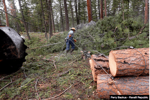
Bob Walker and his small crew have been working to thin out the forest around the Lake Como Recreation Area since last year….“We need to be doing more work to get ahead of the pine beetle. It’s sad to see our forests dying right before our very eyes.”  The project his crew is working on now has that focus in mind.  Over the past year, Walker’s loggers have removed about 60 percent of the trees from most of the recreational sites in the Lake Como area in order to give the remaining trees a fighting chance when the mountain pine beetle arrives en masse.

And now, for the rest of the story, which the Ravalli Republic reporter has been provided a number of times over the years as the Lake Como “forest health” project does its best Energizer Bunny impersonation and “just keeps going…. and going…and going.”

But first, here’s a link to the official 2011 Decision Memo for the “Lake Como Recreation Area Hazard Tree Removal Project.”  Yes, this time I was able to rather quickly and easily find a recent decision memo on a Forest Service website. So perhaps this one-time success will develop into a trend of good luck with Forest Service websites. Of course, in order to get to the “Projects” portion of the website I first had to click on the “Land and Resource Management” link, which includes a somewhat idyllic and pastoral picture of horse logging on the Bitterroot National Forest….which must have taken place at least one time in the past, although I must admit I haven’t heard of any horse logging on the Bitterroot National Forest for quite some time.  But, hey, why not give the public the impression that horse logging is common-place on the forest, right?

OK, on with the rest of the story, courtesy of the local group Friends of the Bitterroot (which, I should point out, counts former loggers, retired Forest Service district rangers, biologists and even the son of the Bitterroot National Forest Supervisor from 1935 to 1955 in its leadership).

Probably the most popular and well used trail on the Bitterroot National Forest snakes through an old growth stand of big ponderosa pines on the north side of Lake Como. The first half mile of the trail is paved to make it handicap accessible. Benches and interpretive signs have been placed as amenities along the way.

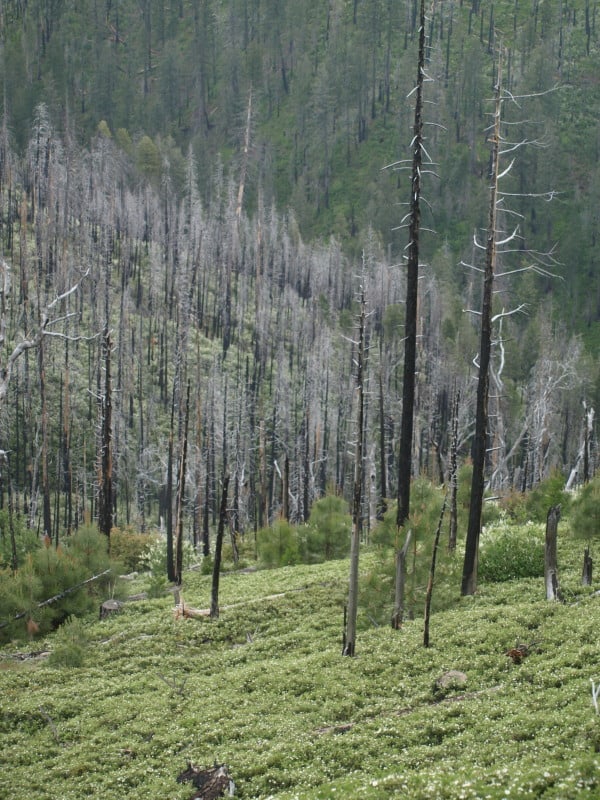
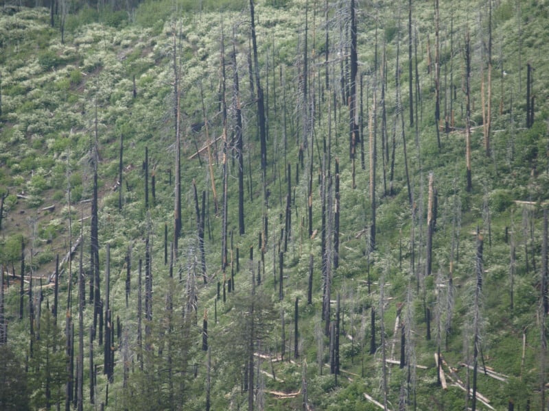
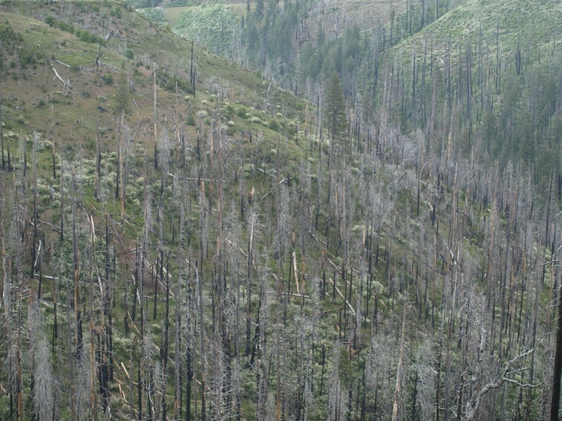
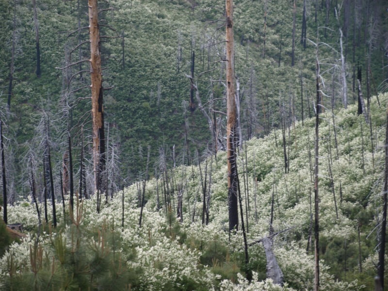
Darby District Ranger Chuck Oliver decided to improve the experience of what was a beautiful old growth pine forest by slashing and burning undergrowth. In April 2004 the area was torched on a hot dry day. The fire erupted out of control and burned many of the prime old growth pines.

Then the Forest Service salvage logged the area and burned the logging slash.

Subsequently pine beetles invaded many of the fire stressed trees and a bunch more big old growth pines died.

This offered the Forest Service another opportunity to salvage log big trees in 2006.

Then the logging slash from that logging was burned.

The end result of the Como fiasco is a handicap accessible paved trail through a thrice burned, twice logged remnant of old growth pine studded with many big stumps.

The new interpretive signs do not tell the reader that the fire was set by the Forest Service and do not point out that the beetle infestation area matches the burned area. The public is given the impression that the events were all natural rather than the results of Forest Service [mis]management activities.

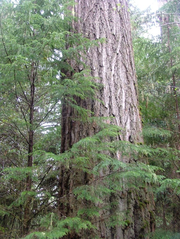
Keep in mind that here we are in 2013 and the Forest Service is still logging trees in the Lake Como Recreation Area, including what appear to be (see photo above) some rather nice looking, green, large-ish ponderosa pines trees.  This would all be funny, if it wasn’t so sad and frustrating.  And, isn’t it absolutely amazing how none of the timeline or facts above about the Lake Como Fiasco make it into this reporter’s “feel good” story?  Equally so, how come none of this history made it into the “background” portion of the Bitterroot National Forest’s 2011 Decision Memo?

But wait…there’s more! The Forest Service now is analyzing yet another project for the area called the “Como Forest Health Project.”  Yep, this is truly a logging project that keeps on giving.

Update:  The Alliance for Wild Rockies has provided a copy of AWR’s scoping comments on the proposed “Como Forest Health Project.”

Where to do what: some thoughts and the Blue Mountains

Map from the Oregonian, Dan Aguayo

Ed raised the question of “where do people on the blog think “intensive management, thinning and prescribed burning” belong.. everywhere? roadless? primitive areas?”

So I’ll go first.

I think that for places where there is no “timber industry” currently:

A. “Thinning for protection” thinning should be done around communities and roads in fire country . We should all work together on building “fire resilient communities and landscapes.” We should analyze all the places fire could start and make sure that for every really dangerous area, there are good areas for suppression between them and communities.

We should work on developing markets for the wood removed, so rural people are employed and we can afford to do it.

We would estimate the acreages and volume through time and then encourage industries to come in and use the material. Watch dog groups would watch to make sure than no more was offered for sale than in the agreement.

When a roadless area or wilderness is in a WUI, we would bring in experienced fire folks and determine if the fire could be fought safely with a break on private land (preferred) or public land.

Otherwise the backcountry would be left alone unless there is some compelling reason for action (protecting endangered species, corridors? or whatever).

B. “Thinning for protection plus resilience” Where there is existing mill capacity, thinnings may also be done if they make stands more resilient to drought and bugs, and they make money (not that they are restoring to the past, but the past had those attributes, say open parklike stands of ponderosa).

Now I was drafting this last night in response to Ed’s question. Meanwhile, I ran across these news stories.. in the Blue Mountains Accelerated Restoration project, it appears to be “thinning for protection plus resilience.” There are several good quotes about the rationale in the story.

The roughly 50,000 acres thinned or logged annually within the four forests is probably less than 20 per cent of what’s needed, Aney said.
“We need to at least double that” to stabilize forest health within 15 years, he said.
The plan Aney will execute calls for managing the Blues in blocks of several hundred thousand acres, instead of the current 30,000-acre planning units. Logging or thinning is likely on no more than 40 percent of each planning unit, Aney said. Individual projects will have to go through environmental reviews.
Work in the woods is expected to start in summer 2014.

Veronica Warnock, conservation director for the La Grande-based Hells Canyon Preservation Council, was more guarded. She said forest restoration is necessary but should be avoided in places where science doesn’t support it, such as stands of old growth or wildlife corridors.

I wonder what “science” that is, that involves what you should or should not do…I thought the role of science was empirical rather than normative. oh well.