Defending private homes near public forests could overwhelm Forest Service — report

 If memory serves, this photo is from Tom Troxel and is in Colorado
I think this photo is from Tom Troxel and is in Colorado.

This is from E&E News here.

Below is an excerpt:

Increased home building on private lots near public forestland could push firefighting costs to levels that nearly consume the Forest Service’s annual $5.5 billion budget, but there is still time to avoid such a disastrous scenario, a new report says.

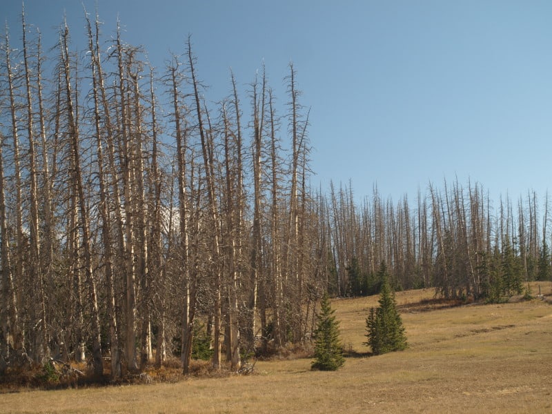
The report, released today by Bozeman, Mont.-based Headwaters Economics, used 2010 Census Bureau data to determine that more than 19,000 square miles of private land near public forests across the West consists of undeveloped but highly sought-after parcels.

If only half these lands within the so-called wildland-urban interface (WUI) were developed, federal firefighting costs could balloon to as much as $4.3 billion, or most of the Forest Service’s annual budget.

Oregon, with more than 5,100 square miles of undeveloped land in the WUI, is most at risk, followed by California (3,800 square miles) and Washington (3,200 square miles), according to the report.

“Our analysis shows that costs for firefighting in the West could grow tremendously in the coming years,” said Ray Rasker, executive director of Headwaters Economics. “The combination of longer, warmer and drier fire seasons — together with more and more nearby homes — will result in much higher expenses for taxpayers along with more difficult and dangerous fire seasons for firefighters.”

Rasker said a key goal of the report is to urge federal policymakers to take steps to shift the responsibility for protecting these homes to the local counties and municipalities that permitted the development.

Among the solutions proposed by Headwaters Economics is mapping areas that are at “high probability” of wildfires and developing financial incentives for local governments to redirect development away from them. Another solution is to eliminate the mortgage interest tax deduction for homeowners who build new homes within the WUI.

“The fundamental challenge is that those who permit and build homes on fire-prone lands — county commissioners, developers and homeowners — do not bear their proportional cost of defending these homes from wildfires,” he said. “We would see a much different pattern of development in the West if the federal government shifted the financial responsibility of defending homes to local governments and those who build homes on fire-prone lands.”

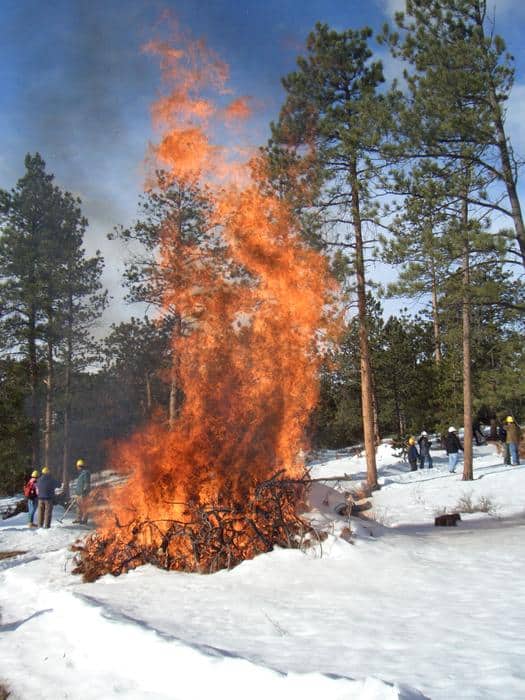
The report by the nonprofit research group comes on the heels of a 2012 wildfire season that ranks among the most expensive in Forest Service history. The Department of Agriculture’s Office of Inspector General has reported that protecting private property from forest fires accounts for at least half of all firefighting costs.

A Forest Service spokesman in Washington, D.C., did not respond to requests to comment for this story.

But the report drew some sharp criticism from Andy Stahl, executive director of Forest Service Employees for Environmental Ethics in Eugene, Ore.

“I doubt that wildfire risk will ever be a driving policy consideration when it comes to local land-use decisions. It never has been. So I’m skeptical it ever will be,” Stahl said.

The reason, he said, is that the risk to homes from wildfires is simply not that great.

“Why isn’t the insurance industry requiring higher [insurance] premiums when building in fire plains as it does when building in flood plains? The answer is that, actuarially speaking, the risk isn’t that high,” he said. “The risk of losing a house to fire is much higher associated with ignition sources from inside the house, such as a poorly installed wood stove, bad wiring. The risk is much, much higher from those traditional home immolation sources.”

The focus, he said, should remain on insuring that homes built in the WUI are built correctly to withstand fires and that homeowners are required to clear bushes and other nearby vegetation that can spread a wildfire.

In Oregon, for example, he said the state has laws in place requiring homeowners to reduce brush and to take over fuel-reduction treatments or risk having to pay the bill for the state to suppress a fire, thus shifting the financial burden to “irresponsible” landowners.

He said concern about development in the WUI is “a surrogate issue” that’s “being used by those who oppose private land-sprawl.” He added, “Trying to use federal firefighting policy as the fulcrum or lever to change the way Montana or anywhere else does its local land-use policy is very much an uphill battle.”

Still, some states are beginning to take the issue seriously.

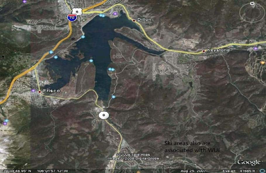
In Colorado, for example, where Headwaters Economics calculates there is more than 1,400 square miles of undeveloped land in the WUI, Gov. John Hickenlooper (D) recently signed an executive order creating a task force composed of state forest and firefighting experts, county and city representatives, insurance providers and homebuilders to study what should be done about growing populations near public forestland, among other issues (Greenwire, Jan. 31).

Note from Sharon: Andy was darn articulate on this, IMHO. I would only add that linking Hickenlooper’s task force and “reducing growing populations” is a bit of a stretch. But don’t take my word for it, here it is from the State horse’s mouth.

Also, the Colorado Roadless workers had many interesting discussions with different groups and university folk about mapping WUI. Let’s just say there are many different ways, which could conceivably yield different answers.

Again, this seems like a question of trade-offs. If our population is increasing, people have to build somewhere. If you live in dry areas, then wildfire is a risk. Sometimes I wish when people did studies saying “don’t do that, it’s bad” they would also say “do this instead, it’s better.”

Utah’s High Elevation Mortality

P9066744-web

This picture is located within the Cedar Breaks National Monument, where conifer mortality is quite excessive. There is really not much that can be done with this situation, other than spending lots of money to fell, pile and burn. Within the Dixie National Forest, this mortality dominates the upper elevations. Even at this altitude of over 10,000 feet, the land is very dry for 9 months, except for seasonal lightning storms. Like some of our public lands, we need a triage system to deal with such overwhelming mortality and fuels build-ups. In this example, we are too late to employ a market-based solution, which would do more non-commercial work.

I have seen this area over many years, and have watched as forests die and rot, with catastrophic wildfire being the “end game”. Anyone venture a guess at what will grow here, in the future?

www.facebook.com/LarryHarrellFotoware

Enviros protect 8,000 acres of old-growth, or hold people of Utah ‘hostage?’

This blog has highlighted the Dixie National Forest, Utah, “Iron Springs Vegetation Reduction Project” before.  Yesterday, the Salt Lake City Tribune reported:

Wildlife conservation groups on Thursday praised a decision by Dixie National Forest withdrawing a plan to harvest 8,000 acres of old-growth forest near Escalante.

“Conservationists are calling this a valentine for wildlife,” said Kevin Mueller, program director for Utah Environmental Congress. “The withdrawal really is a reprieve for wildlife.”….

Mueller said the harvest has appeared dead at least three times before, as far back as 1999.  “This is a horrible game of whack a mole that’s been going for about a dozen years, and I just really hope the Forest Service gives up the ghost on this project and doesn’t resurrect it again,” he said.

The timber harvest area of 8,306 acres is about 15 miles northwest of Escalante at elevations ranging from 9,000 to 10,750 feet. Mueller said the trees that were to be cut down are an estimated 150 to 400 years old.  Conservation groups have fought the harvest, saying the trees provide needed nesting and forage habitat for the threatened Mexican spotted owl and sensitive-species goshawk….

Rep. Mike Noel, R-Kanab said opposition by groups outside of Utah like the Montana-based Alliance for the Wild Rockies, is a “perfect example” of why state officials want to take control of public lands. “This is another reason why our Utah lands and forestry people and local people can do a better job of managing lands because we’re not held hostage to groups in … other areas,” he said.

Research Reveals that Crown Fires Can Kill Trees and Cause Difficulties with Tree Regeneration

A flood of ash and sediment fills the washes in the white mountains after the fire; photo by Dan Neary

This headline reminds me of the past weekend’s Research Reveals that Elk Eat All Year.

Nevertheless, thought I should post this article… I am looking for the link to the research study. Note: journalists out there- please put the links in your stories.

Here’s the link and below is an excerpt, but the whole piece is of interest.

The researchers spent years exhaustively measuring the contrasting recovery of two stretches of forest, both on Stermer Ridge at the headwaters of the Little Colorado River. They estimated the surviving trees, the amount of wood on the ground, stream flows, soil absorption, the total mass of grass and shrubs and the number of elk, deer, squirrels, rabbits and other animals.

#Watershed A suffered a high-intensity crown fire, which means the flames jumped from one treetop to the next — rather than burning along the ground. The fire killed about 55 percent of the trees immediately — and about 75 percent of the survivors within a year or two. The patch of ground ended up bereft of trees, with even the fire-adapted gambol oaks mostly dying off along with the ponderosas and junipers.

#On the adjacent Watershed B, a road served as a firebreak that halted the crown fire next door. Instead, the fire there burned along the saplings, shrubs and downed wood on the ground. It consumed 5 percent of the trees immediately, with a total of about 15 percent dying from the effects of the fire in the next two years.

#The study demonstrated the dramatic effects of such high-intensity fires.

#For instance, the searing heat of the crown fire fused the soil in Watershed A, sharply reducing the rate at which the ground could absorb water — making it “hydrophobic.” Two-thirds of Watershed A had strongly hydrophobic soil and one third has moderately water repellent soil.

#By contrast, in Watershed B only one-third of the soil was strongly and 15 percent moderately hydrophobic.

#The combination of the loss of the trees and the changes in the soil produced dramatic changes for the next three years whenever it rained.

#For instance, a storm on Watershed A produced a stream flow that was 2,230 times what would have flowed into that same stream with the same amount of rainfall before the storm, according to estimates. By contrast, the storm increased stream flows in Watershed B by about 50 percent compared to pre-fire levels.

#In the fall of 2002, the severely burned area lost about 28 tons of topsoil per acre to erosion, compared to about 17 tons per acre in the moderately burned area. In the spring of 2004, the severely burned area lost 35 tons of topsoil per acre compared to about 20 tons in the moderately burned area. A stable area in a normal year will lose almost no topsoil to erosion.

#The figures offer a sobering cautionary note for Rim Country, whose water future now depends on the Blue Ridge Reservoir, which sits in a small, wet, thickly forested watershed. Payson officials have urged the U.S. Forest Service to make thinning the watershed of the Blue Ridge Reservoir a high priority, for fear a crown fire could cause a dramatic increase in erosion — which would reduce the life of the deep, narrow reservoir.

#The study found that plants, grass and shrubs returned to both areas quickly — with the severely burned area actually producing more grass and shrubs initially than the lightly burned area. That’s probably because in the lightly burned area most of the trees survived and continued to shade the ground and compete for water with the ground cover.

#Elk actually used the severely burned area more than the lightly burned area initially, probably reflecting the initial, denser growth of grass. Mule deer returned quickly to both areas, but in smaller numbers.

#On the other hand, many of the smaller animals like rabbits remained all but absent in the severely burned area — along with pine tree dependent species like Abert’s Squirrels.

#Fewer birds also returned to the severely burned area, probably because they no longer had the diverse habitat offered by the tree canopy.

Yes, you heard some of these observations first by individuals on this blog. I would just comment that people can figure out how to plant trees and get them to grow back. About 40 years ago the Forest Service started a major effort to figure it out. The FS had reforestation experts hired, administrative studies of various cultural practices and nurseries to experiment with practices, investments in refrigerated trucks and tree coolers, etc. If we had a small amount of the bucks directed to downscaled modeling, I bet we could figure it out.

Wildfire Risk Management on a Landscape with Public & Private Ownership: Who Pays for Protection?

We’ve had these sorts of discussions here before in regards to people building homes in fire-prone forests with an expectation that the federal government (and US taxpayers) will provide funding for fuel reduction activities.  A new(ish) research paper provides another look at the issue.

Abstract: Wildfire, like many natural hazards, affects large landscapes with many landowners and the risk individual owners face depends on both individual and collective protective actions. In this study, we develop a spatially explicit game theoretic model to examine the strategic interaction between landowners’ hazard mitigation decisions on a landscape with public and private ownership. We find that in areas where ownership is mixed, the private landowner performs too little fuel treatment as they ‘‘free ride’ —capture benefits without incurring the costs—on public protection, while areas with public land only are under-protected. Our central result is that this pattern of fuel treatment comes at a cost to society because public resources focus in areas with mixed ownership, where local residents capture the benefits, and are not available for publicly managed land areas that create benefits for society at large. We also find that policies that encourage public expenditures in areas with mixed ownership, such as the Healthy Forest Restoration Act of 2003 and public liability for private values, subsidize the residents who choose to locate in the high-risk areas at the cost of lost natural resource benefits for others.

Burning Slash Piles Now OK in Colorado; Prescribed Burns Waiting For Science

csfs-burning-slash-piles-cynthia-cox-cottam

Here’s a link and below is an excerpt.

The amended burn order acknowledges “burning remains the least expensive and most effective method” for removing slash piles to reduce the risk of wildfire, but says the fires will be allowed only when there is a minimum of 4-6 inches of snow on the ground. The order also requires neighbors of potentially affected areas, local governments and the media to be notified.

Hickenlooper said experts tell him that prescribed burns to eliminate dense forest undergrowth are crucial for mitigation, but said the science behind them must be considered before prescribed burns beyond burning slash piles is brought back.

A second executive order created the 12-member Wildland and Prescribed Fire Advisory Committee to work with the director of the Division of Fire Prevention and Control to improve wildfire preparedness, response, suppression and management of prescribed fires.

The group’s tasks include “work to ensure continued safety and protection for residents on the wildland-urban interface, while promoting the health and longevity of our state’s natural forests through properly regulated pile burnings.”

With the third order, Hickenlooper created the 17-member Task Force on Wildfire Insurance and Forest Health to review issues related to coverage — including replacement costs of destroyed homes, accounting for personal property losses, relocation assistance and timeliness of insurance benefits.

The task force is also to look for ways insurance policies could provide incentives to landowners to promote forest health and reduce fire risks.


Note from Sharon: In our effort to see beyond partisan boundaries, I am going to start drawing attention to the party and location of politicians involved in our issues. Governor Hickenlooper is mostly a Metro-Elk kind of guy but being Governor has made him more aware of Colorado’s rural areas. He is a D. I don’t know if it’s him, or the nature of Colorado, but task forces seem like ways to approach bipartisan or nonpartisan solutions. It seems to me (hypothesis) that wildfires are a larger share of state business in the Interior West than the more urban and wetter Western Seaboard states, and so we might see some interesting policy solutions come from this part of the west.

Too Big to Bite Off at One Time: Beetles and Fire

table of types 2
The above is an attempt to show ( a small portion of) the variety of conditions that might be included under “bark beetles and fire” in the western US. Types are Ponderosa Pine, Lodgepole Pine, Mixed Conifer and Spruce-Fir. Beetles are Western Pine, Mountain Pine and Spruce. I apologize for the low quality of the table, especially the graphics but also including that I don’t know what beetles are in which types in which regions for sure.

This discussion of bark beetles and fire has been fascinating! Clearly, a given fuel treatment project might occur under a variety of conditions (including WUI and not). But if you look at the variety of types (I tried to make some generalities about the locations of people on this blog), it’s pretty easy to determine that a simple question like Bob asked about fungal breakdown, can vary by slope and aspect, species and a variety of other conditions within one of these larger regions. So this table is not a finished product (obviously) but I think most people might think “bark beetle fuel loadings” might be a very different thing with spruce beetle in spruce fir on the Rio Grande, mountain pine beetle in lodgepole in Central Oregon, etc.

Perhaps we could try referring to a specific region, type and species when we talk about bark beetles and fire?

I know this discussion started with the NASA study, but really. 1. NASA has satellites, 2. Used them at a scale that works for their tool, 3. Had bucks to study stuff, 4.some imply say that a correlative analysis at that scale is relevant to fuels management that occurs on a local scale. It’s 3 that’s the real value judgment.

Suppose folks on this blog were funded to design research that would answer the question “what is the best use of federal bucks in promoting fire-resilient communities?” Or even the simpler, “how should fuel treatment dollars be prioritized?”

Reply from Cal Wettstein on Bark Beetles and Fire

cal wettstein

Cal is retiring fro the Forest Service; currently his is the Acting Deputy Forest Supervisor on the White River, so you might want to send your greetings to him.. Here’s an article about him, when he was bark beetle incident commander (you may have to answer some strange questions to get to the content).

Below is his answer to the question Andy Stahl raised here, regarding a quote from Cal in this story.

On the BB fire thing, first, I won’t miss the political arguments over it….. but really, I looked at the NASA clip and the naysayers (ie Veblen, Kulakowski, etal) continue to miss the big picture. We’ve been very clear that in pure lodgepole pine, during the red-needle stage ignition is easier and we can get flashy crown fires, but they only last one burn period—there’re no heavy fuels to carry fire for very long. The BB fire connection is several decades out. The dead trees fall over 15-20 years (hopefully they’re not disputing the effects of gravity), creating a heavy fuelbed of 60-80 tons per acre. The next forest grows up through that fuelbed and the combination of heavy down fuels, residual mature trees that weren’t killed by bugs, and regeneration that will serve as ladder fuels, set the stage for intense large scale fires—not over the next few months or years as implied by the NASA piece, but over decades—40-50 years. I know the intent of these ongoing arguments is to keep management in check in the short term—so we don’t overdo the knee-jerk reaction to red trees, but the work we’ve been focusing on in the WUI is aimed at much longer term. Andy needs to look at the longer term. Bottom line is, despite high-priced NASA landsat analyses or convoluted GIS exercises, we know from real-life fire experience that a fuel model with 60-80 tons of heavy fuel per acre is going to be problematic when it eventually burns—especially in and around homes and infrastructure.

Well, I could go on and on but I’d be wasting breath…. So I’ll just say that I would never assert that BB’s cause large scale intense fires—BB’s are just one integral part of numerous extremely complex systems that also include fire.

Note: what Cal says is not very different from what I’ve been saying and what we told the local Colorado scientists at various meetings. So possibly some folks didn’t listen to what we said, or they didn’t believe us, or other places are very different from Colorado. Each possibility raises a variety of intriguing questions, IMHO.

How Climate Change Could Wipe Out the Western Forests

In The Atlantic.

So what I think it interesting about this is that we don’t actually know if conditions will suit trees in the future, just logically some tree genotypes and species might be replaced by others. Do you want to give up on trees at all, say in New Mexico and Arizona, or do you want to try planting? Do you trust climate models to tell you what the climate is going to be like in 2050, or do you want to figure out strategies that might work under a variety of climate scenarios? If, as the last paragraph says, we “haven’t had landscapes like this,” will we have to change our expectations of where associated wildlife species can live?

Here’s the link and here is an excerpt.

Climate change can’t take all the blame for the severity of the fires or the other problems forests are facing in the U.S. and around the world. But here at least, much of the blame can be pegged to other kinds of human activity. A bad year for fires in 1879 laid waste to huge swaths of American forest — thanks to a drought, but also to the ongoing efforts of settlers burning off forest to make way for homes and agriculture. As Teddy Roosevelt put it several years later, when he was pushing for better conservation of the nation’s natural resources, “The time has come to inquire seriously what will happen when our forests are gone.”

The trees grew back, but the destruction led to extensive areas predominated by same-age trees, which are now just the right size for a beetle attack, according to Sibold. In the 1900s, Americans swung in the opposite direction. They became overprotective of their forests and suppressed many fires, which allowed fuel to build up and made conditions ripe for more extreme burns now.

The scientists don’t like to characterize the changes to the Western scenery as “bad.” Many prefer to stay neutral with words like “different” and “unique.” But when pressed, they sound concerned, and gloomy. “We haven’t had landscapes like this,” Sibold said. “You have all of these things interacting, and it’s generally not good news if you’re a tree in Colorado.”