In the study, they used trip report info from this group.
I came across a very interesting research paper from 2018 by Fisher et al. here. The title is: Recreational use in dispersed public lands measured using social media data and on-site counts.
Basically it says that user-generated data from social media can be used to get information about recreation use in dispersed areas and supplement NVUM. It potentially sounds like a great source of detailed information on recreation use, although I suppose we couldn’t tell what kind of vehicle, or not, they are using. Unless you got trip reports from different kinds of user groups.
*Note: this is not what the authors did but… As a recreationist, it would be cool to have GPS of where recreationists are in real time (not sure this is possible technically or due to privacy concerns). Would people opt in? Folks could get information on where other people are.. and could go elsewhere, maybe reducing crowding at the more popular sites, and getting people to spread out (good for Covid). I’m not sure about the environmental benefits of spreading out vs. crowding. It would also be very cool if GPS from phones could be used to alert recreationists to forest fires as well. But maybe this is already happening as part of evacuation notifications.*
Back to what the authors did. Social media potentially sounds like a great source of detailed information on recreation use. It seems like an interesting possibility to explore, especially since recreation patterns and numbers seem to be changing due to Covid- even as travel management decisions are being made that consider patterns of use.
If anyone knows more about either real-time data collection and notification, or other folks who have used social media data, please add your comment.
Here’s the abstract:
Outdoor recreation is one of many important benefits provided by public lands. Data on recreational use are critical for informing management of recreation resources, however, managers often lack actionable information on visitor use for large protected areas that lack controlled access points. The purpose of this study is to explore the potential for social media data (e.g., geotagged images shared on Flickr and trip reports shared on a hiking forum) to provide land managers with useful measures of recreational use to dispersed areas, and to provide lessons learned from comparing several more traditional counting methods. First, we measure daily and monthly visitation rates to individual trails within the Mount Baker-Snoqualmie National Forest (MBSNF) in western Washington. At 15 trailheads, we compare counts of hikers from infrared sensors, timelapse cameras, and manual on-site counts, to counts based on the number of shared geotagged images and trip reports from those locations. Second, we measure visitation rates to each National Forest System (NFS) unit across the US and compare annual measurements derived from the number of geotagged images to estimates from the US Forest Service National Visitor Use Monitoring Program. At both the NFS unit and the individual-trail scales, we found strong correlations between traditional measures of recreational use and measures based on user-generated content shared on the internet. For national forests in every region of the country, correlations between official Forest Service statistics and geotagged images ranged between 55% and 95%. For individual trails within the MBSNF, monthly visitor counts from on-site measurements were strongly correlated with counts from geotagged images (79%) and trip reports (91%). The convenient, cost-efficient and timely nature of collecting and analyzing user-generated data could allow land managers to monitor use over different seasons of the year and at sites and scales never previously monitored, contributing to a more comprehensive understanding of recreational use patterns and value
Some campsites are occupied by people who living in the South Platte Ranger District. The Forest Service is testing a new system that converts the 450,000-acre district’s campsites into designated pay campsites that can be reserved. (Courtesy U.S. Forest Service via Colorado Sun)Perhaps eclipsed by Election Drama and wildfire news, there has been a major Covid-enhanced increase in recreation in the last year, at least on some western National Forests. Here’s an interesting story from the Colorado Sun on how the South Platte Ranger District is responding. The writer, Jason Blevins, interviewed a range of folks and it seemed like everyone agreed that something needed to be done and this approach makes sense.
“We were experiencing high volumes of users camping on every single road across the entire district and it was getting to the point where we were seeing huge resource impacts,” said Banks, mirroring an oft-repeated lament of Forest Service officials charged with protecting lands in other heavily impacted locations.
The South Platte District started testing the concept of pay, reserved diverse campsites eight years ago. This fall Banks’ team identified 340 sites that will be converted, with assigned parking spots, pit toilets and fire rings. That number will likely grow. As many as 94 sites will be managed by a concessionaire, Rocky Mountain Recreation Company.
Campers will have to pay somewhere around $15 a night. The concessionaire will have to direct 19% of gross revenues back into those campsites. The cost of the sites will pay for pumping out and cleaning pit toilets, Banks said.
“We are basically at a point on the South Platte where we can’t continue to do things the same way and expect different results,” Banks said. “We have to try something new.”
Other district rangers are keeping close tabs on the pilot program, especially after the deluge of campers across all of Colorado this summer, Banks said.
The traffic during the pandemic accelerated a trend driven by a new generation of campers looking for a different experience than a traditional campground, he said. These new-school adventurers are OK with fewer amenities in exchange for privacy and a wilder feel. They are buying RVs and camping trailers like crazy to get farther afield and off the beaten track.
“Paying a reduced fee for dispersed designated sites is something that is appealing to them,” Banks said.
Not all the campsites in the district are going to be available for online reservations, leaving options open for Front Rangers who make the late call to jump in the car and camp on Friday or Saturday night. But off-highway-vehicle users who travel from across the country to explore the Rampart Range trails have expressed support for the reservation system that enables them to lock in a spot for their vacation before they arrive.
Banks also has heard from district old timers who used to be able to drive into the district and camp and shoot anywhere they wanted. But times have changed, he said, and “change can be really hard and I’m sensitive to that.” He tells them straight: “Our ability to provide for recreation in a sustained capacity is no longer effective under the current system.”
Jim Peasley has been riding dirt bikes and camping in the Rampart Range for more than 50 years. The longtime liaison officer for the Rampart Range Motorcycle Management Committee has shepherded the construction and maintenance of hundreds of miles of trails in the range’s motorized recreation area, deploying his committee’s volunteers with federal and state support.
“I’ve seen a lot of changes,” he said.
But over the past five to 10 years, the pace of that change has accelerated. In recent years Peasley has seen more people who are transient setting up semi-permanent camps at spots that once were used by weekend campers. The nonprofit committee that formed in 1972 has traditionally resisted the South Platte Ranger District’s push toward more designated, pay campsites.
“But honestly, in the last few years it’s gotten so bad that even our members can’t find a decent place to camp so we finally as a committee decided to get on board,” Peasley said.
…and
Patricia Cameron founded Colorado Blackpackers in 2019 as a way to get more people of color outdoors. Her nonprofit leads camping trips and outdoor excursions as well as offering free and discounted gear.
She says Blackpackers serves those “at the intersection of economic vulnerability and underrepresentation.” And she’s wary of how fees on public lands can become obstacles for people who want to spend more time outside.
“Anytime you put a cost on something, regardless of the amount, you start limiting people and leaving people out,” she said.
But the new reservation system could make camping trips less intimidating for newcomers, she said, eliminating the first-timer angst that comes with trying to find a campsite in a forest filled with more experienced — and largely white — campers. So Cameron hopes the reservation system, even though it costs money, could lower other barriers that can prevent people of color from getting outside and hopefully sparking a passion that could lead to more outdoor experiences.
If folks have questions about this I’m willing to yard them up and ask. Here are mine.
1. Don’t other forests have paid dispersed sites? I’ve seen designated dispersed sites but they are not reserved/paid for.
2. How did they pick 19% as the percent of gross revenues that comes back?
3. Are employees managing the other campsites (340-95) that the concessionaire is not? Do all the revenues from those return directly to the District?
Wilderness designation has always been controversial in Montana. No new wilderness areas have been established by Congress since I believe 1977, and unlike most states there has never been statewide wilderness legislation. The Blackfoot-Clearwater proposal to designate 90,000 acres on the Lolo National Forest was locally developed and has been pending in Congress for several years. Its development included addressing issues related to motorized and mechanized recreation that we have been discussing here, and designates areas for both. This article provides some background, and includes a link to the written statement from the Forest Service regarding the proposed legislation.
The statement relates to forest planning in a couple of ways. First, the Forest Service uses the Lolo National Forest forest plan as the foundation for its position on the legislation.
We also have concerns about implementing section 202, which establishes the Spread Mountain Recreation Area for the apparent purpose of enhancing mountain biking opportunities. The Lolo’s current land and resource management plan identifies this area as recommended wilderness. This area is characterized generally by steep topography, sensitive soils, and contains sensitive fish and wildlife habitat. Trail 166 is the main access into this area. This trail is not maintained, not passable by riders on horseback, and becomes difficult to locate after the first mile. While we acknowledge the interest in expanding opportunities for mountain biking on the Lolo, we are concerned that the site designated for the Spread Mountain Recreation Area is not well-suited for this use, and that this designation could create conflicts with wildlife and other recreation uses.
Two of the three wilderness designations in Title III are consistent with the recommendations made in the existing Lolo National Forest land and resource management plan. The third designation (West Fork Clearwater) was not recommended in the management plan to be Wilderness, it was allocated to be managed to optimize recovery of the Grizzly Bear.
One might argue that the 1986 forest plan is outdated, and recent local efforts should be given greater consideration. However, those efforts have not been through any formal public process, so I commend the Forest Service for using its forest plan. I’m not sure whether NFMA’s consistency requirement applies to taking positions on legislation, but it is probably the right place to start. The proposal is also interesting in its legislative designation of two “recreation areas,” taking these decisions out of the forest planning process.
The Lolo is scheduled to begin its forest plan revision process in 2023, and the Forest Service is also concerned about the interaction between the revision process and this legislation. It sounds like mostly a budgetary concern:
Our primary concerns pertain to Title II. Section 203 which would require the Forest Service to prepare a National Environmental Policy Act analysis for any collaboratively developed proposal to improve motorized and non-motorized recreational trail opportunities within the Ranger District within three years of receipt of the proposal… If passed in its current form, this bill could require recreation use allocation planning for site-specific portions of the Seeley Lake Ranger District ahead of the broader plan revision process, which would forestall the Lolo’s ability to broadly inform land use allocations across the forest through the plan revision process… If enacted, the explicit timeframes currently contained in the bill could result in prioritizing the analysis of a collaboratively developed proposal to expand the trail system over other emergent work.
But they might also be suggesting that the site-specific recreation planning would benefit from waiting until the forest plan is revised. (Or maybe they just don’t like deadlines.)
It’s time to do something, what exactly? More money, more enforcement, ?. What should we (jointly) do and who (what organization(s)?) should take the lead? Note: it’s not just National Forests and BLM.
Here’s a link to the commentary (in the Denver Post) and some excerpts, but I encourage reading the whole piece.
When talking with managers of state and federal public lands these pandemic days, two issues popped up: what to do about large amounts of human feces deposited in wild places and how to handle far too many visitors. Both issues have served as a wake-up call to both land managers and environmentalists about the downsides of recreation.
“It’s like we’ve stared into a future that wasn’t supposed to arrive for a few decades,” said Randy Carpenter, who works with the community-planning organization FutureWest, in Bozeman. “The crush of people and the ecological impacts of rising recreation uses is right here, among us — right now — and it’s transforming the character of wild places.”
A paper published in the scientific journal PLOS One reviewed 274 scientific studies completed between 1981 and 2015 that examined the effects of recreation on a variety of animal species across all geographic areas and recreational activities. Kevin Crooks, a conservation biologist at Colorado State University, said given what we know now, “It might be time to establish limits on public access to protected areas and encourage changes in the behavior of recreationists.”
Though conservation groups continue to point fingers at logging, mining and ranching, they’ve been slow to acknowledge impacts from outdoor recreation. Last winter, at a U.S. Forest Service meeting in Jackson Hole, Wyoming, biologists noted that backcountry skiing and snowboarding were harming a dwindling, isolated herd of bighorn sheep. Displaying what can only be called a crass attitude, one skier was heard to remark: “Well, the sheep have had these mountains for 10,000 years. Now it’s our turn.”
I’d argue that it’s long past time to encourage changes in the behavior of recreationists. And it was only a matter of time before the “protected” line is drawn further and further up the Pyramid of Pristinity.
Some recreationists insist on a quid pro quo: They’ll advocate protecting public land only if they’re allowed to use some of it. It’s happened in Idaho over wilderness and recently in debates over how to safeguard wildlife habitat in the Gallatin Range of southwest Montana.
An outdoor industry eager to get its slice of an $800 billion pie helps fuel the rush to the West’s public lands. Farrell says that outdoor-product manufacturers push hard for increased access to public lands in part because more users boost their bottom lines.
Meanwhile, many state tourism bureaus – like those in Montana, Wyoming and Utah — spend millions of dollars advertising national parks and other places that are already uncomfortably overcrowded.
“Critical discussions about recreation are rare because these activities are layered with a thin veneer of innocence,” Farrell said. This recalls a narrative of heedless use that goes back to the 19th and 20th centuries: Exploit a special place until it’s used up and then move on, leaving waste, damage and displaced wildlife behind. The problem is there aren’t many true wild places left to exploit.
I don’t agree with Farrell on the outdoor industry critique- mostly because much of those bucks are for OHV’s and RV’s which already don’t belong in protected areas. Of course, OIA has a political slant, so the whole issue is very complex (outdoor industries and their attitudes to recreation access and other uses of federal lands).
And so it goes, “wild places” must have only few people, using preferred kinds of recreation. As we clamber up the Pyramid of Pristinity, we continually meet new enemies and they are all us. So what is to be done?
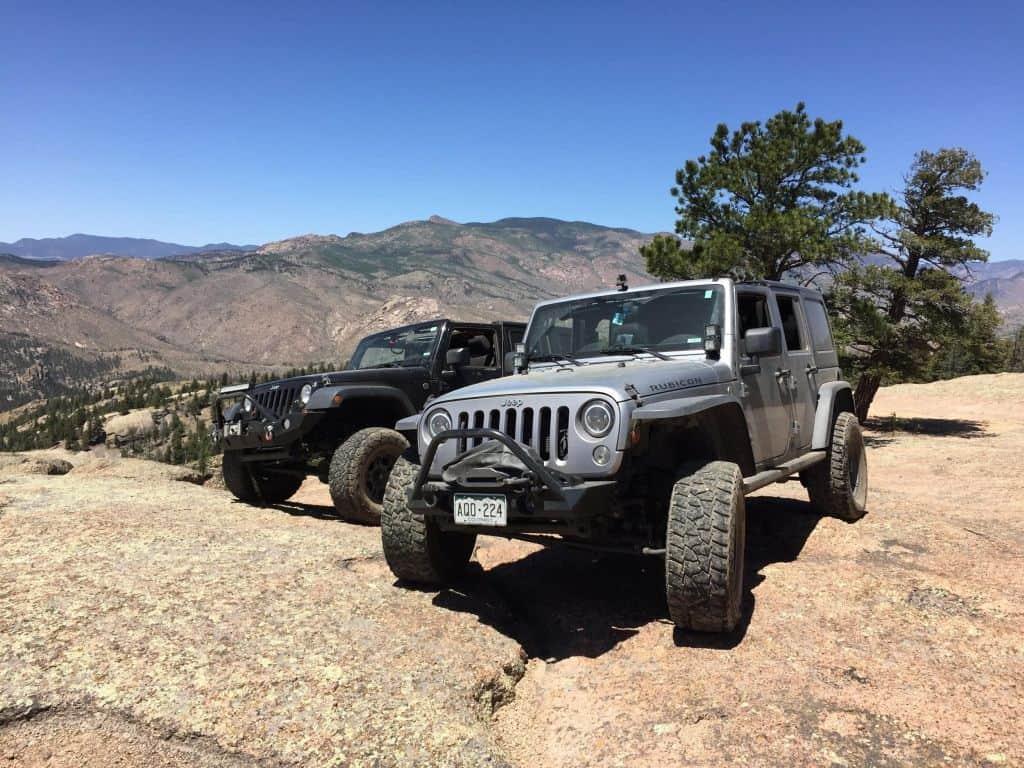
The author’s Jeep on the currently open section of the Hackett Gulch trail in Wildcat Canyon.
Patrick McKay is a board member of Colorado Offroad Enterprise (CORE) and Colorado Offroad Trail Defenders.
A coalition of motorized access groups led by Colorado Offroad Enterprise (CORE), has recently uncovered a disturbing plot by officials in the Pike San Isabel National Forest to illegally close one of the most popular motorized trail systems in Colorado in circumvention of the ongoing travel management process and in violation of the National Environmental Policy Act (NEPA).
Background
For many decades, off-road vehicle enthusiasts nationwide have enjoyed driving the rugged four-wheel-drive roads in Wildcat Canyon in the Pike National Forest. Located in a steep canyon along the South Platte River about an hour’s drive west of Colorado Springs on the border between Teller and Park Counties, these Jeep trails are also known as “The Gulches” after the three primary trails of Hackett, Longwater, and Metberry Gulches. Since roughly the late 1950s, these roads have been one of the most popular off-road trail systems in the Front Range for recreation enthusiasts seeking adventure, offering a unique set of off-road challenges, river access for swimming and fishing, and spectacular scenery in a rugged gorge filled with towering rock formations.
Since the early 2000s, however, Wildcat Canyon has been ground zero for one of the most contentious battles in Colorado between off-roaders and environmental groups determined to close these roads and lock motorized users, but not themselves, out of the canyon in the name of “conservation.” In 2002, the area around Wildcat Canyon was devastated by the Hayman Fire, the largest wildfire in Colorado history. All of the roads in the region were temporarily closed after the fire, and the Forest Service subsequently began working on a new environmental analysis to determine how to manage the roads in the burn zone.
After a highly contentious public comment period with off-road groups facing off against environmental groups wishing to close Wildcat Canyon to motorized use, the Forest Service issued a decision in 2004 which concluded that re-opening the roads in the canyon was the best option both to meet the public demands for motorized recreation and to protect the environment. However, due to its limited resources, the Forest Service would only allow the roads to be reopened if the relevant county governments agreed to take responsibility for maintaining these roads.
Teller County immediately applied for and was quickly granted easements allowing it to take over management of the eastern half of the Gulches trail system, which was reopened to the public by 2009, with the Colorado Springs off-road group Predator 4WD agreeing to maintain the trails on behalf of the county as they had already done for many years prior.
Park County, which contains the western half of the trail system, first applied for an easement in 2008. In contrast to Teller County, Park County’s attempts to obtain easements were repeatedly stonewalled by the Forest Service. Ultimately, Park County submitted no less than four easement applications between 2008 and 2014, with each being met with either silence or excuses from the Forest Service such as claims to have lost the paperwork or not having the budget to process it. Internal Forest Service emails obtained by CORE show agency employees, including two different South Park District rangers, repeatedly searching for reasons not to grant the easements and attempting to discourage Park County officials from moving forward with their request.
Finally in 2015, Park County Manager Tom Eisenman retracted the county’s easement application, apparently without obtaining the approval of the Park County Commission, leaving the Park County roads in limbo. With the eastern half of the trail system open and no signs or barriers at the county line to indicate the roads in Park County were closed, they have continued to be regularly driven by motorized users to this day.
New Travel Management Process
Also in 2015, a lawsuit by a coalition of preservationist groups resulted in a settlement agreement in which the Pike San Isabel National Forest agreed to completely re-do its motorized travel plan with a new travel management process. During the scoping period in 2016, the Forest Service received numerous comments asking it to reopen the closed roads in Wildcat Canyon.
The Forest Service responded by including an alternative in the draft EIS published in 2019, which considered reopening some (but not all) of these roads, leaving out crucial connecting routes to restore the loop opportunities provided by the original trail system. This analysis was flawed from the start, as it relied on a 2015 Travel Analysis Report written by South Park District Ranger Josh Voorhis. That report rated most of these roads as having low recreational value solely because they were currently closed, rather than considering the incredibly high value they had for motorized recreation when they were open, which had been repeatedly acknowledged by the Forest Service in prior environmental analyses.
Internal emails show that Mr. Voorhis strongly opposed including these roads in the travel management EIS at all, as he had already decided to permanently close and decommission them. As a result of the wide latitude Voorhis was given in making decisions for the roads in his district, the preferred alternative in the 2019 draft EIS proposed to decommission almost all of the Wildcat Canyon roads in Park County, with no indication that any serious consideration was ever given to reopening them. The preferred alternative also contained more road closures in the South Park District than in all other districts combined.
The Plot to Decommission the Roads
Instead of waiting for a final decision on the Wildcat Canyon roads to be made in the travel management process, Mr. Voorhis (along with South Platte District Ranger Brian Banks) decided to circumvent that process entirely and began working with local anti-motorized user groups to illegally decommission the roads with no environmental analysis or public involvement.
In May of 2018, Voorhis wrote an internal memo kicking off a decommissioning project with three elements: (1) Removing all existing metal signs and fencing from the Park County roads, (2) installing heavy metal barriers blocking access to the closed Park County roads from the open roads in Teller County, and (3) re-contouring the roads on the west side of the river to physically remove them from the ground. Another Forest Service employee strongly objected to Voorhis’ plan, saying in an email that decommissioning these highly desirable roads in a controversial area with no supporting environmental analysis or public input was illegal and invited distrust and justified outrage from the motorized community.
Nevertheless, Voorhis moved forward with his project, purchasing the metal barriers in the summer of 2019 and searching for contractors to install them that fall. Simultaneously, he and a Forest Service biologist with a demonstrably strong bias against motorized recreation wrote up a document claiming “changed circumstances” which would prevent Park County from being granted an easement under the 2004 EA, thereby thwarting a renewed push by CORE and other motorized groups to get Park County to re-apply for an easement in spring 2019.
It was during the public comment period for the draft EIS in fall 2019 that CORE first became aware of Voorhis’ plans to decommission these roads, when he unsuccessfully sought permission from Teller County to barricade the roads on the east side of the canyon further up in Teller County. CORE subsequently hired an attorney to file a FOIA request for all Forest Service documents pertaining to Wildcat Canyon, which we obtained in early 2020.
The Forest Supervisor’s Response
Having learned through the documents provided in response to our FOIA request of Voorhis’ plans to install permanent barriers blocking access to the Park County roads sometime in 2020, CORE wrote to Forest Supervisor Diana Trujillo this spring asking for her assurance that no actions would be taken to decommission any roads in Wildcat Canyon until after a final decision was made in the travel management EIS.
After a phone conversation with the Supervisor in May, Deputy Forest Supervisor Dave Condit wrote to us on her behalf on July 1 stating that, “The Forest does not plan to do any work on the roads in Wildcat Canyon this year. There will be no changes until we complete our Travel Management Final Environmental Impact Statement (FEIS) and sign the subsequent project Record of Decision (ROD).”
Unfortunately, this assurance turned out to be false. On the same day Mr. Condit sent his email, Wild Connections (the lead environmental group pushing for closure of Wildcat Canyon) published their July monthly newsletter in which they announced they had received a grant from Park County and permission from the South Park Ranger District to move forward with a “metal removal project” in Wildcat Canyon later this summer.
This project was the same as the first element of Mr. Voorhis’ decommissioning plan from May 2018, removing all the old signs and fencing from the Park County roads in preparation for obliterating the routes from the ground. Those signs and fences were originally placed decades ago by Predator 4WD in partnership with the Forest, and continue to be helpful today in preventing drivers who inadvertently drive the closed roads without knowing of the closure from going off trail. They would also be critical for this purpose if the roads were ever legally reopened.
When CORE contacted Ms. Trujillo again in August with these concerns and asked her to prevent Wild Connections from completing this project until a final travel management decision has been made, she dismissed our concerns, falsely claiming that the metal removal work was not decommissioning and it would not affect the outcome of the travel management process. This is unfortunate as it shows the Forest has no interest in partnering with or maintaining the trust of motorized groups who wish to see these trails reopened, and has already predetermined to close them regardless of public demand for motorized recreational opportunities in Wildcat Canyon.
Conclusion
At this point CORE has no choice but to assume the Forest has not been proceeding with good faith in this matter, and to prepare for inevitable objections and likely litigation over the Forest Service’s malfeasance regarding these roads. We are calling on all motorized recreationists to write to Supervisor Trujillo, as well as the Park County Commission and other elected officials, expressing extreme disappointment over the decision to proceed with decommissioning these roads before the travel management process is complete.
The fight is not over yet. The off-road community in Colorado is hopeful that, if enough individuals get involved and show that motorized recreation is important to them, these treasured roads will once again be open to all outdoor recreation enthusiasts
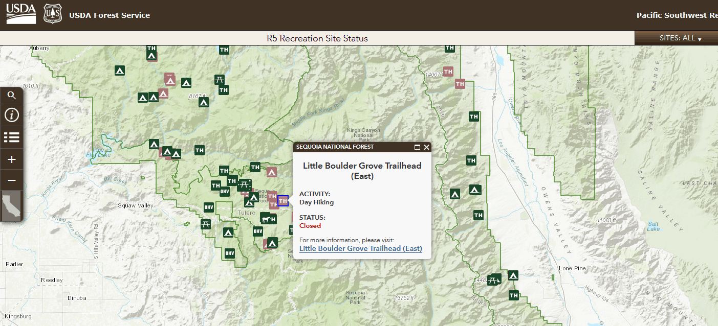
Many interesting things but I liked the recreation status map:
Recreating responsibly will help ensure that expanded access to recreational facilities, services, and opportunities continue. We ask for your help to continue getting this word out. This
summer, we launched a Geographic Information System (GIS) map that provides the public with updated information on the status of campgrounds, day-use sites, picnic areas, and other designated recreation sites on national forests throughout California…before they travel. You can view the GIS map at https://www.fs.fed.us/r5/webmaps/RecreationSiteStatus/.
I was also very pleased with the signing of the Great American Outdoors Act, which will enable federal land managers to take aggressive steps to address deferred maintenance and other infrastructure projects on national forests and grasslands. It will allow us to deliver higher quality customer service, enhance the visitor experience, and serve as a major catalyst for rural
economic development and employment opportunities through the projects funded and the resulting increase in tourism and recreation activity.
The Forest Service anticipates up to $285 million nationally, and up to $60 million regionally, on an annual basis over the next 5 years from the National Parks and Public Land Legacy
Restoration Fund. The bill also provides $900 million annually to the USDA and DOI through the Land and Water Conservation Fund, which will improve access to public lands, further
strengthening the recreation economy based on national forests and grasslands. Recreation on national forest lands in California contributes over 2 billion dollars to the California economy.
The agency is diligently working to provide priority lists to the Department regarding federal land acquisition and deferred maintenance projects on national forests and grasslands.
I guess I hadn’t realized the scale of $ of GAOA at the Regional level. Of course, he says “up to 60 mill on an annual basis” for the Region, and I don’t know what factors would influence the “up to”. Anyone have more info on this?
I’m always interested in the concept of paying for recreation. Why is it OK in State Parks and National Parks, but not OK for the FS and BLM? Why is it OK for hunters and fishers and OHVers to pay via licenses and/or taxes, but not others? Is there some kind of fairness/justice issue here?
Recently in Colorado, the Department of Parks and Wildlife required people to buy hunting or fishing licenses to recreate in State Wildlife Areas. I belong to several hiking Meetup groups and when the info was shared, the general feeling seemed to be, “oh that makes sense, if we use it we should pay.” The twist that many of us didn’t get (like me, why not have a permit that combines with State Park access for a cheaper combined fee?) was that there are bureaucratic obstacles to what you call the charges. From the CPW FAQs.
Why didn’t my SWA Access Permit contribute to CPW? The SWA Access Permit was not recognized under the Federal Aid Program as a valid hunting or fishing license. The current SWA Access Permit system, used on only four SWAs, negatively impacted the CPW wildlife finances. The monies generated from this access permit fund lessens the following year’s Federal Aid monies used by CPW by the amount the SWA Access Permit fund accumulated.
Why did the Commission not consider creating a wildlife watcher license that can be used to access wildlife properties?
Any wildlife watcher license would have issues similar to those created by the State Wildlife Area Permit (see above).
Here is a story from the Colorado Sun titled “Opposition Grows” by Jason Blevins.
Where does the opposition come from? (my comment in bold)
Several recreation groups — including Colorado Mountain Club, Colorado Mountain Bike Association, American Whitewater, Great Old Broads for Wilderness and Boulder Climbing Community — are urging the Colorado Parks and Wildlife Commission to consider the new rule’s impact on recreation. In a letter to the commission, those groups noted how many State Wildlife Areas are popular for uses beyond hunting and fishing. The groups pointed to places like Bergen Peak in Jefferson County, Dome Rock next to Mueller State Park, the Loma Boat Launch in Fruita and the Buena Vista Whitewater Park as locations that now require users to be licensed to access.
American Whitewater pointed out more than 60 popular river segments that pass through State Wildlife Areas. Colorado Mountain Club noted there are more than 20 popular hiking trails that overlap with State Wildlife Areas.
Access to open spaces — part of a statewide initiative called Colorado The Beautiful that connects residents with parks and trails — crosses State Wildlife Areas and requiring a license to cross those lands could limit access for underprivileged communities, Julie Mach, conservation director for the Colorado Mountain Club, said during the Colorado Parks and Wildlife Commission meeting on July 17.
(Charging for access, camping, licenses or taxes at any Park or Forest or Wildlife Area could limit access for underprivileged communities anywhere, is this a good argument?)
“There is, I think, a lot of confusion from the recreation standpoint on how CPW is treating these areas when it comes to non-consumptive recreation,” said Mach, whose group suggested possible exemptions from the licensing regulations for hikers and paddlers passing through these properties.
It also sounds like excessive people may be bothering wildlife.. which CMC and GOB at least, seem very concerned about when other people than non-motorized recreationists do it.
CPW said the reason for the change is the sites have seen a significant increase in use outside of hunting and fishing. Those uses include walking dogs, horseback riding, ATV riding, hiking, wildlife watching and kayaking and canoeing. It said that has disrupted wildlife and harmed wildlife habitat and impacted the hunters and anglers who help pay for the properties through license purchases.
While many of the properties are still primarily used by hunters and fishers, some areas are heavily visited by those other users.
CPW spokesman Travis Duncan said the agency doesn’t have specific numbers of people using the properties but said it is evident that use has greatly increased over the years and the COVID-19 pandemic has only added to the increase.
“We have seen so much more non-wildlife related use of these properties that we need to bring it back to the intended use of conservation and protection of wildlife and their habitat,’’ CPW Director Dan Prenzlow said.
and
Colorado Parks and Wildlife, which does not receive taxpayer dollars, collects 10% of the revenue generated by the Colorado Lottery — roughly $3.4 billion over the last 36 years — but that goes toward the state’s 41 parks. Wildlife areas and trust lands that are managed for protecting animals and their habitat are supported by angler and hunter license fees.
In recent years, wildlife officials have reported increases in people hiking, biking, paddleboarding, camping and driving off-road vehicles in areas managed for wildlife. In some places, officials have found people setting up semi-permanent living situations. Many visitors assume that recreation in those areas is free, Duncan said.
“But if you are out recreating, it has some kind of impact and it has some kind of cost,” he said.
It’s kind of interesting that there’s apparently no “hey it only seems fair to pay” group to weigh in, or be quoted. Maybe we should start one.
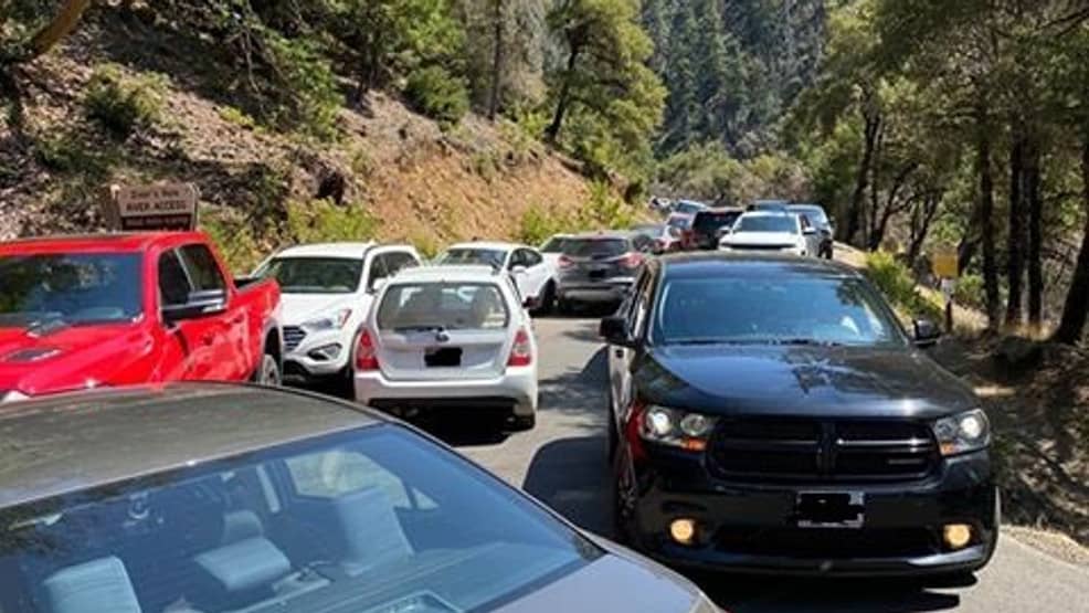
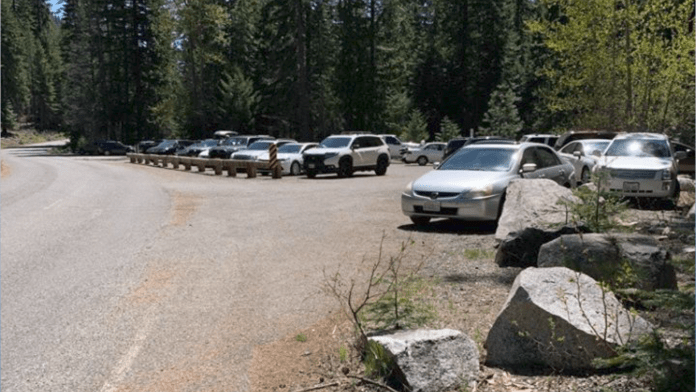
Crowded sites like this during the coronavirus pandemic have National Forest managers concerned. (U.S. Forest Service)
Forest Service retirees in Region 2 recently received a note from Acting Regional Forester Jennifer Eberlien that said:
This year has certainly brought on more challenges to our public lands as we are seeing unprecedented numbers of forest visitors across the forests and grasslands. While this means more members of the public are learning about and enjoying our public lands, it also means that every program area across the Region is feeling the increased pressures in our jobs.
Our Regional Leadership Team is discussing these issues at length and actively seeking additional support for employees, both for personal well-being and physical, psychological, and social safety, as well as for the protection and conservation of our natural and cultural resources that we hold so dear. Though we may not immediately have big and swift options for change, we can certainly work together and incrementally continue to raise awareness of conditions across our lands and the effects it is having on our employees, our users, and our resources.
So this is an opportunity to collect info from various parts of the country. Have you seen any news stories, or have you observed yourself/spoken with people involved?
1. Has your area seen increases in people and camping on National Forests/BLM due to Covid-19?
2. Earlier in the year, outfitters I spoke with said that out of state bookings were down (planned vacations from out of state/country, as opposed to day or weekend trips). They were encouraging Front Range types to come and fill in some of the gaps. How does this look in your part of the country in terms of locals/nearby metros (if any)/out of state/country visits?
3. In the Colorado Springs area, we’ve also had what seems to be cases of local communities closing off places where people traditionally accessed National Forests due to some combination of avoiding Covid-19/too many people/too many people not behaving well. Have you seen any of this?
4. Based on observing previous years, there may be more people recreating on the National Forests around here during the week.. possibly due to more work from home and more flexible work schedules, and perhaps the need to get the kids outdoors and socially distanced. What have you experienced or read about?
5. What about recreation businesses? Here’s an example of a story on increases in RV sales. Here’s an example of a story on outdoor recreation businesses being hard hit by Covid. Maybe people are going to more individual and less guided recreation? Or perhaps the far-away people are staying away? Or perhaps in the Rockies, there are more people from neighboring States with no mountains and lotsa heat? What about other regions?
In the interest of crowdsourcing information on National Forest activities, I’m wondering how things are opening up in your neck of the woods. Coming back through a city last Friday, I noticed almost as many campers and trailers heading for the hills as in a non-Covid year.
Governor Polis of Colorado asked travelers to be sensitive to host communities and try to avoid stopping in them. In Colorado, State Parks have been open for hiking throughout the pandemic and recently opened to camping. National Forest campgrounds have been shut down, but dispersed camping on National Forests and BLM is very popular.
Many people prefer dispersed camping to campgrounds. Though part of their argument is that it’s free, and I don’t think that’s fair. I wish people who do dispersed camping would pay a voluntary $70 ish fee per year (I’ve given up on fees for now), about the same as a State Park pass, that goes into costs of the program. As part of the package, they could get discounts from nearby businesses, education on how to reduce impacts and be good neighbors, plus a link to a website to report areas that need attention by the land management agency (like this Recreation Monitoring System, currently only in Colorado). Yes, there is a problem that there currently is no such not-for-profit set up to channel the donations, but that wouldn’t be difficult to accomplish.
What continues to amaze to me is that the massive weekend migration to the woods, not managed by anyone, works as well as it does. Or perhaps no one is monitoring the Law Enforcement Officer reports for potential news stories.
I did notice that the Pike San Isabel Travel Management EIS (2-26) described an alternative not analyzed in detail:
“Designated Dispersed Camping Alternative
This alternative is focused on resolving confusion with short, dead end spur routes that currently provide for dispersed motorized camping.
Key ideas are as follows:
•Limit closure of short, dead end spurs currently open to dispersed camping, to limit the shift of impacts elsewhere
•Convert these routes to parking locations only if on-site vehicle camping is permitted and clearly marked to avoid impacts
•Change the current strategy on the PSI of having dispersed motorized camping forest-wide to designated dispersed motorized camping, where all locations are inventoried and clearly marked
It seems to me that many forests near me allow dispersed camping, with signage when it is not allowed in specific places (I guess open unless closed). But I don’t think that’s the case everywhere. Is it by the Region, by how urbanized the area is or some historical factor or ???? Are there groups that want to reduce dispersed (vehicle) camping on its own, or is reduction of dispersed camping just a by-product of the desire to close roads?
Please share:
(1) How about your neighboring Forests? What are their policies on dispersed camping?
(2) What did it look like out there (on the National Forest) last weekend in terms of numbers?
We’ve talked about whether mountain bikes should be allowed in areas recommended for wilderness designation by the Forest Service in a forest plan, for example, here. Most of the angst has been related to a policy adopted by Region 1 that many interpret as excluding this use because allowing it would reduce the likelihood that an area would actually be designated. Here’s an example from another region of how a forest plan would address this question. This language is from the draft EIS for the Nantahala-Pisgah National Forest revised plan (North Carolina). While this is written about the effects of wilderness designation, the DEIS also makes it clear what activities the Forest thinks would create a risk to future wilderness designation options.
Wilderness recommendation and designation would remove the potential to generate revenue from timber production, forest product sales, and other land uses which support surrounding development such as utility or transportation corridors. No new mineral claims would be filed, but valid existing claims would be allowed to operate.
Existing roads within recommended areas would either continue to be maintained as linear wildlife fields or decommissioned and allowed to return to a natural state. No new wildlife fields would be created nor any timber harvest activities allowed. Restoration activities where the outcomes protect wilderness characteristics would be allowed to continue, including monitoring, relocation of animals, habitat improvements such as removal of nonnative fish species and nonnative invasive plant species, stream improvements, and rehabilitation of recreation impacts.
Existing trails would continue to be maintained to allow for hiking and equestrian use per current trail-use designations, but mechanized transport such as bicycles or carts would be prohibited in all recommended areas (with exception of approved mobility devices for the impaired). Commercial collection of non-timber forest products such as galax or ginseng, would not be permitted; however, collection for non-commercial or tribal purposes would be allowed. Other commercial activities such as recreation special-use events would also be prohibited in areas recommended for wilderness designation.
The mountain bike decision by the Forest was the followed discussions with a public working group, which also included consideration of whether future wilderness recommendations could be conditioned on providing adequate mountain bike trails. The location of the trails was potentially less important than the amount, but it is unknown at this time where additional trails might be and how that might affect wilderness boundaries. Consequently, trails in a potential wilderness area could be managed to phase out the existing but unauthorized mechanized use gradually after providing other comparable opportunities, and when certain conditions were met, appropriate areas would be formally recommended, with the full support of both mountain bike and wilderness groups. But the Forest ended up recommending the area for wilderness, which would exclude the use.
In effect, the Forest appears to have considered an alternative that would have not recommended an area, but committed to a process that would recommend some or all of it as wilderness in the future (presumably with a plan amendment) when certain objectives are achieved. You don’t find this alternative mentioned in the DEIS, though, as one considered but eliminated from detailed study.
Back in R1, the Nez Perce-Clearwater draft revised plan includes a suitability designation regarding mechanized use in all areas recommended for wilderness designation in a particular alternative. Of the four action alternatives, one has no recommended wilderness and one would allow mechanized use in the areas recommended. (The DEIS does not say what the current direction for recommended wilderness is.) There is no preferred alternative.