“The National Forest Management Act emerged as a response to the clear-cutting and timber harvest controversies of the 1960s and ’70s. To this day, people differ as to whether it provided much-needed course correction for the Forest Service or instead was a solution to a “nonexistent” problem. What the law does, essentially, is require the agency to prepare management plans for every forest. It also places significant environmental constraints on the Forest Service and gives it a mandate to manage for wildlife diversity.”
Wildlife diversity, yes, but also other resources and values. It is worth noting that the text of the NFMA cites the Multiple-Use, Sustained-Yield Act of 1960 a dozen times or so.
This article from the Yakima (Wash.) Herald, “Future full of doubt for Central Washington timber industry,” highlights a familiar theme: A “small mill is the only one remaining in the Eastern Cascades from Yakima County to the Canadian border. That means while more than a million acres need thinning, there’s no place else buying the wood.”
And, “Experts say the solution is to rebuild the timber industry, but by focusing on small logs now in abundance and encouraging innovative companies that use waste wood for manufactured products or biomass energy to invest here.”
How to do that? The first step is to provide long-term supply agreements, the articles says. IMHO, not just 10 years, but 20, at least.
This topic has been discussed in numerous posts. This report is worth a look: Forest fires in Sierra Nevada driven by past land use. It will not come as a surprise to people who have traced the Indian use of fire in the Sierras and more recent actions/policies.
“We were expecting to find climatic drivers,” said lead co-author Valerie Trouet, a UA associate professor of dendrochronology. “We didn’t find them.”
Instead, the team found the fire regimes corresponded to different types of human occupation and use of the land: the pre-settlement period to the Spanish colonial period; the colonial period to the California Gold Rush; the Gold Rush to the Smokey Bear/ fire suppression period; and the Smokey Bear/fire suppression era to present.
That said, drought is certainly a factor in the current and expanding die-off of pines in the Sierras, but that may not be a climatic change.
With a new Republican President and a Republican-controlled Congress, how will this affect the Forest Service and the BLM?
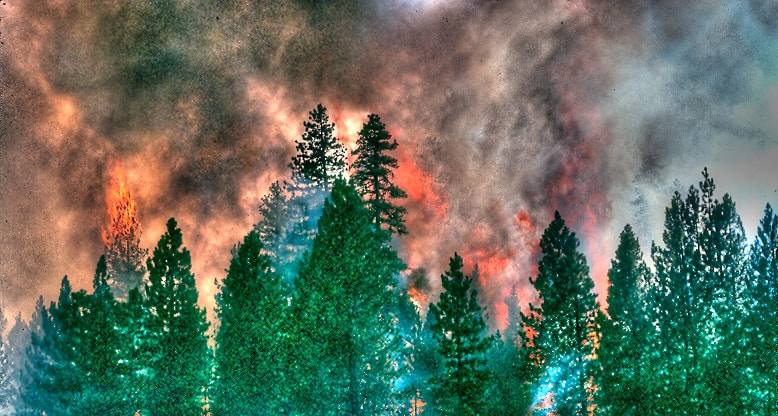
Regarding the picture: I did some processing with a High Dynamic Range (HDR) program to get this artsy view. It is interesting that it enhanced the flames better than in the original scan, from a Kodachrome slide. I shot this while filling in on an engine, on the Lassen NF, back in 1988.
Seems like you can’t talk about national forest management these days without also talking about wildfires. As an environmentalists I’ve gotten used to being blamed for wildfires no matter what the truth or the reality really is. Heck, environmentalists were even blamed by Montana Senator Steve Daines for this summer Roaring Lion Fire on the Bitterroot National Forest…even though that fire was started by some irresponsible teenagers and a lawsuit against a proposed timber sale and roadbuilding project in the area was filed – not by any environmental group – but by a local homeowner/property owner who happens to be a former U.S. Forest Service smokejumper and the owner a wood products manufacturing company. Go figure.
In the decade between 2006 and 2015, humans started nearly half of the 73,110 wildfires on national forest lands.
Campfires were responsible for one-third of the 33,700 human-caused wildfires in that decade. Those fires burned over 1.2 million acres.
This year saw 8,500 acres burned in the Roaring Lion fire outside Hamilton. Four young people were charged last week with negligent arson, a felony, for allegedly leaving the campfire that started that wildfire, which destroyed 16 homes and cost $11 million to fight.
“It’s a significant issue for us,” said Jennifer Jones of the U.S. Forest Service’s Fire and Aviation Management office in Washington, D.C. “We have a finite number of fire personnel and equipment. The more that we have to allocate to fight human-caused fire, the fewer we have to fight the fires we can’t prevent, which are those caused by lightning.”
This piece in the New York Times from Christopher Ketcham seems worthy of discussion on this blog. In Montana, public lands issues have been the centerpiece of pretty much every single statewide campaign this year. However, to date, not one politician in Montana has said anything about last week’s verdict in the Bundy Trail, and what that may mean for the safety of thousands of public lands employees in our state, or the future management of America’s public lands. Then again, I’m not sure I can think of one single example of where any statewide politician in Montana has ever said anything negative about ranchers that graze their livestock on our federal public lands for literally pennies on the dollar, at a tremendous impact to native wildlife, watersheds and the heath of our range and forested ecosystems. -mk
With the jury acquittals last week of Ammon and Ryan Bundy and their accomplices in the 41-day armed takeover of the Malheur National Wildlife Refuge in Oregon last winter, the lives of federal land managers in the American West got a whole lot more difficult.
This was more than just a court victory.
The Bundys landed a blow against a culture of public service embodied by the federal employees responsible for maintaining law and order and protecting our wildest Western landscapes. And while we don’t know the reason for the acquittals in what seemed like an open-and-shut case of guilt, it comes against a backdrop of deep antipathy in parts of the West toward the environmental regulation of the hundreds of millions of acres of rangeland, forests and national parks managed by the federal government on behalf of all Americans.
This hostility is particularly strong in the high desert of southeastern Oregon that is home to the refuge, described by the environmental historian Nancy Langston in an Op-Ed article earlier this year as “a place of bitterly contested human histories that remain potent today.”
The federal land managers I’ve spoken to — rangers, biologists and law enforcement officers, almost all of them so fearful they won’t go on the record — worry that extremist copycats who seek to undermine the federal public lands system will be emboldened by the verdict.
On September 17, an arsonist is suspected of setting six fires along a remote one-mile stretch of gravel road near the Soup Springs campground on the edge of the Modoc’s South Warner Wilderness. Four of the fires were contained promptly at less than a half-acre each and a fifth was held to less than 300 acres after a couple of days. The sixth, called “Soup 2,” escaped initial attack. Blown by westerly prevailing winds, it moved uphill to the sparsely-vegetated wilderness where, over the course of a week, it burned about 2,200 acres.
On day 2, for example, over 900 firefighters were assigned to the fire as it burned largely, and appropriately, unchecked into the wilderness. On day 3 alone, the Forest Service spent $909,655!
Why spend so much money watching a fire burn into the wilderness, with nothing of consequence threatened and season-ending rain in the forecast? One explanation might be the $2.3 million in “indirect” costs the Modoc national forest is allowed to charge to the fire. With the fiscal year about to expire at the end of September, every national forest has an incentive to spend as much as possible against the agency’s $1.6 billion wildfire suppression account. Which may help explain how the Forest Service managed to spend its largest fire appropriation in history during a decidedly uneventful national forest fire season.
Note that the study was performed by three activists who are strongly opposed to logging: Curtis M. Bradley (Center for Biological Diversity), Chad T. Hanson (John Muir Project), Dominick A. DellaSala (Geos Institute).
From their paper’s conclusion: “In general, our findings—that forests with the highest levels of protection from logging tend to burn least severely—suggest a need for managers and policymakers to rethink current forest and fire management direction, particularly proposals that seek to weaken forest protections or suspend environmental laws ostensibly to facilitate a more extensive and industrial forest–fire management regime.”
The following is a press release from the University of California-Berkeley. mk
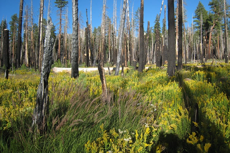
A severe fire cleared an area of forest in the Illilouette Creek Basin in Yosemite National Park, allowing it to become a wetland. Wetlands and meadows provide natural firebreaks that make the area less prone to catastrophic fires. Scott Stephens photo
Berkeley — An unprecedented 40-year experiment in a 40,000-acre valley of Yosemite National Park strongly supports the idea that managing fire, rather than suppressing it, makes wilderness areas more resilient to fire, with the added benefit of increased water availability and resistance to drought.
After a three-year, on-the-ground assessment of the park’s Illilouette Creek basin, University of California, Berkeley researchers concluded that a strategy dating to 1973 of managing wildfires with minimal suppression and almost no preemptive, so-called prescribed burns has created a landscape more resistant to catastrophic fire, with more diverse vegetation and forest structure and increased water storage, mostly in the form of meadows in areas cleared by fires.
“When fire is not suppressed, you get all these benefits: increased stream flow, increased downstream water availability, increased soil moisture, which improves habitat for the plants within the watershed. And it increases the drought resistance of the remaining trees and also increases the fire resilience because you have created these natural firebreaks,” said Gabrielle Boisramé, a graduate student in UC Berkeley’s Department of Civil and Environmental Engineering and first author of the study.
Boisramé and co-author Sally Thompson, a UC Berkeley ecohydrologist and assistant professor of civil and environmental engineering, found that even in the drought years covered by the study, the basin retained more water than similar areas outside the park. That translated into more runoff into the Upper Merced River, which flows through Yosemite Valley, at a time when other rivers in the surrounding areas without a restored fire regime showed the same or decreased flow.
“We know that forests are deep-rooted and that they have a large leaf area, which means they are both thirsty and able to get to water resources,” Thompson said. “So if fire removes 20 percent of that demand from the landscape, that frees up some of the water to do different things, from recharging groundwater resources to supporting different kinds of vegetation, and it could start to move into the surface water supplies as stream flow.”
The study was published in this month’s issue of the journal Ecosystems.
If the results are confirmed from other studies, including the UC Berkeley team’s new project analyzing the Sugarloaf Creek Basin in Sequoia and Kings Canyon national parks, they could alter the way the federal government as well as water districts deal with fire, benefiting not only the forest environment but potentially also agriculture and cities because of more runoff into streams and reservoirs.
“I think it has the potential to change the conversation about wildfire management,” said co-author Scott Stephens, a fire expert and UC Berkeley professor of environmental science, policy and management who has studied the Illilouette basin since 2002.
This “wildfire management” strategy is counter to the federal government ‘s 110-year-old Smokey Bear policy, which is followed throughout the West and emphasizes suppressing fires wherever they occur for fear they will get out of control. With persistent drought and a warming climate, the U.S. Forest Service budget is increasingly going to firefighting. On most federal land, only forest thinning and human-initiated prescribed burns are allowed as a way to manage the trees and underbrush.
Stephens noted, however, that these agencies have recognized the folly of total suppression – thanks in part to his own studies throughout the Sierra Nevada over several decades – and current draft wildland management policies for three of the state’s national forests allow active wildfire management in up to 60 percent of the forests.
The value of forest clearings
Wildfire management, as opposed to suppression, comes with major changes in the way the forest looks, Stephens and Thompson said. Unlike the dense stands of pine and fir most people associate with Yosemite and similar mid-elevation Sierra Nevada and Rocky Mountain forests, the Illilouette Creek basin has thinner forests and more clearings with dead trees.
“There is much more dramatic structural change in this forest than most people would probably feel comfortable with,” he said. “You are talking about low-density forests and gaps of 4 or 5 acres, up to maybe 100 acres. These are the result of major fires about every decade or so, large enough to cause tree scarring and affecting as much as one-quarter of the basin.”
These fire-caused clearings, however, act as natural fire breaks and make the area resistant to catastrophic fires such as the 2013 Rim Fire in the western part of the park, which burned 250,000 acres and left patches up to 20,000 acres in extent in which not a single conifer tree survived. These areas could take a century to recover, Stephens said.
“In the Illilouette basin we lost about 20 percent of the forest cover, but there was a 200 percent increase in wetland vegetation: meadows starting to reemerge from forests that have probably encroached on historical locations,” Thompson said. “That sets us up to think that this new regime should be leakier as far as water goes — leaky in the way that suits us as a society.”
Even if these wildfire management techniques don’t produce more runoff, Thompson added, “I think it is a fabulous result in terms of forest management if you end up with a healthier forest with some better intact aquatic habitat, even if you don’t see a drop of water further downstream. It is still the right thing to do from an ecological point of view.
“Bottom line, this strategy might be a triple win-win-win for water, forest structure and fire risk,” she said.
The ‘jewel’ of Yosemite National Park
The findings are the culmination of a 14-year study led by Stephens and his UC Berkeley colleagues to learn how monitoring natural, lightning-caused fires with a bias toward letting them burn affects the landscape, the vegetation and the groundwater. Only four areas in the western U.S., including two in California – the Illilouette Creek basin and the Sugarloaf Creek basin – have allowed lightning fires to burn in large areas for decades.
Most studies of different ways to manage wildland fires have been limited to a few hundred acres, and it’s hard to extrapolate from such limited experiments to an entire forest. Luckily, Yosemite National Park started its experiment in 1973 – spurred by a 1963 report authored by the late UC Berkeley forester Starker Leopold – to let nature take its course in the Illilouete Creek watershed, stepping in only when fires in the basin threatened to get out of control or sent too much smoke into Yosemite Valley two miles to the northwest.
“This is the first study that looks at fire regime restoration on a watershed scale with empirical data,” he said. “Others do smaller areas or modeling, but this is 40,000 acres – a big place – over many years.”
One reason the basin was chosen was that it was surrounded by granite walls, which naturally prevented fires from spreading outside the basin. It had not been burned by the indigenous tribes of the region, which often set fires to increase acorn production, and had no history of prescribed burns. In fact, it saw only natural, lightning-caused fires except for an interval of nearly a century – 1875 to 1972 – when the park suppressed all fires.
While Stephens and his many students documented the changes in fire over the past 400 years, Boisramé and Thompson analyzed aerial photos to document vegetation change. Then, with the help of installed sensors and more than 3,000 soil moisture measurements throughout the basin, the team was able to estimate the amount of water in the landscape today versus in the past. They found similar or marginally drier conditions where forests had been replaced with shrubs, but these were balanced by much wetter conditions in small areas where meadows expanded.
They observed more snow reaching the ground because of the clearings, and more snow remaining during the spring, delaying runoff. And in recent drought years, when surrounding basins saw more trees die, there was almost no tree mortality in the Illilouette basin.
“In order to really understand whether this approach should be part of our management toolkit, I would recommend that we give it a crack in a few other places,” Thompson said. “This appears to be a promising management strategy without significant harm and with several very strongly quantifiable benefits and several very suggestive outcomes.”
Boisramé, who spent the past four summers sampling and camping in the Illilouette Creek basin, emphasized that this is not a strategy that would work everywhere. But in wildernesss areas where wildfire management is being considered because of its safety benefits – to reduce underbrush and eliminate fuel for out-of-control and catastrophic fires that risk lives and property – the ecological and hydrological benefits are a big bonus. Areas with similar elevation and climatic conditions to the Illilouette basin, and thus perhaps suitable for managed wildfire, comprise about 18 percent of the Sierra Nevada, though the strategy may work at lower elevations as well.
“The whole ecosystem will be better off if we let the natural fire process back in,” she said.
The research was supported by a grant from the federal Joint Fire Science Program.
“Clean water tops wish list in Northwest as feds revise plan,” according to an article on Greenwire about a poll of 600 registered voters in counties in Washington, Oregon and California, commissioned by the Wilderness Society.
The results of the poll are here. As with most polls, the wording of the questions can have a strong influence on the responses. In this case, the questions seem framed to mirror the activities and outcomes desired by the Wilderness Society. For example, to this question:
“Let me read you some specific components of ways that have been suggested to revise the Northwest Forest Plan and get your reaction. For each, please tell me if you would favor or oppose that component.”
These are the components given to respondents:
Improve trails and campgrounds to enhance recreation opportunities.
Prioritize restoring forests to their natural conditions.
Limit logging and road building within 300 feet of rivers, lakes, and streams.
Limit logging and road building in old-growth forests.
Limit the use of clear cut logging operations.
Designate certain areas to be managed primarily for carbon storage, which will minimize impacts of climate change.
Restrict road building in areas where roads can interfere with the movement of wildlife.
What do you think? Is is a fair and balanced poll?

