AFRC: Fuel Reduction Supports Firefighters, Protects Communities During Oregon’s Flat Fire

This is from AFRC’s August 2023 newsletter. It reminds me of shaded fuel breaks I helped maintain many years ago on the El Dorado NF, using Rx fire and/or mechanical brush removal (AKA grunt work projects — fire crews with chainsaws). Here’s a good video about these fuel breaks and the 2021 Caldor Fire.


Fuel Reduction Supports Firefighters, Protects Communities During Oregon’s Flat Fire

Fuel reduction projects are often maligned by those who oppose active forest management. Critics point to the fact that, during certain conditions, no amount of fuels reduction will stop large fires from burning out of control. Although evidence suggests that fuels-reduction projects and timber sales can have a moderating effect on fire behavior during even the largest conflagrations; it is true that when conditions become extreme, a 200-foot fuel break will have little ability to “stop” a fire.

Where anti-forestry groups miss the mark on fuel reduction projects is in judging their effectiveness where it counts – during active firing operations. Such is the case on the Rogue-Siskiyou National Forest, where years of fuel reduction work and strategic timber sales have given firefighting personnel a leg-up in their effort to control the 2023 Flat Fire.

The Flat Fire started on July 15 in the Oak Flat Campground near the town of Agness, Oregon. Strong winds, hot and dry conditions, and an abundance of snags and brush leftover from the 2002 Biscuit Fire, enabled early growth on the Flat Fire. Within a week over 20,000 acres had burned and there was a real threat that the fire could push into Agness or Gold Beach if left un-checked. Snags not only provided easily combustible fuel for the fire, but they also complicate firefighting efforts as crews cannot mobilize where the risk of overhead hazards are too high. Simply-put: due to the fuel loads, the forecasted weather, proximity to communities, and the occurrence of the fire so early in the season, the Flat Fire threatened to become an historic conflagration.

Fortunately, the Flat Fire started near a ridgeline that the Rogue River-Siskiyou National Forest had long identified as a critical control point within their boundary. Wildhorse Ridge begins above the confluence of the Rogue and Illinois Rivers near Agness and extends south for about 19 miles, before terminating near the confluence of the Pistol and North Fork Pistol Rivers. As a strategic control point, Wildhorse Ridge is the first line of defense between fires coming out of the Kalmiopsis Wilderness and the town of Gold Beach.

The importance of Wildhorse Ridge played out in 2002 during the Biscuit Fire, where crews were able to contain the fire’s westward advance along Wildhorse Ridge, thus preventing continued destruction of public and private resources during what was (at the time) the largest wildfire in state history. Although much of the forested area between the Kalmiopsis Wilderness and Wildhorse Ridge had burned completely during the Biscuit Fire, many green islands of lightly burned timber remained.

Following the Biscuit Fire, the strategic importance of Wildhorse Ridge was increased as it now not only protected Gold Beach, but also an immense swath of unburned timberland of mixed public and private ownership. To bolster the ridgeline’s defense, and to impart greater resilience within the moderately-burned green islands, the Forest began a series of timber sales and fuels reduction projects along this ridgeline starting in 2006. The aim of these projects varied from non-commercial fuels reduction to conventional timber sales via commercial thinning. These projects were also designed to ensure that that roads across the ridge remained in drivable condition in the event of necessary emergency response.

The effectiveness of these projects was tested this summer during the early days of the Flat Fire, and it didn’t take long before the value of these treatments became clear. As the fire broke out, firefighting personnel were able to utilize the roadway to quickly gain access to the fire’s origin and establish an anchor point, preventing spread towards Agness. As the fire progressed south, Wildhorse Ridge became an invaluable resource to move personnel in and out safely. Treatments along the ridge made it possible for firefighters to safely backfire into the main fire and eliminate flashier fuels between the main fire and the ridge without the risk of putting fire into overgrown fuels.

The Forest was also able to take advantage of some breaks along the way. The 2018 Klondike fire afforded the Forest the opportunity to reopen containment lines along the fire’s eastern front, and weather moderated at pivotal points to allow firefighters to gain ground on the fire. But while good fortune can be a saving grace during fire season, nothing compares to hard work and preparation. The Rogue River-Siskiyou National Forest was well-prepared to utilize Wildhorse Ridge during the Flat Fire because of their own hard work.

It’s still too early to predict the final impacts of the 2023 Flat Fire. The fire continues to burn, and there is no end in sight for the year’s fire season. But as of August 28, the Flat Fire is 34,242 acres, 58% contained and has grown very little in the past few weeks. This comes as a welcome relief as the Forest must divert resources to their Wild Rivers Ranger District, where the Six Rivers Complex along the OR/CA border continues to advance into Oregon.

If the Rogue River-Siskiyou can hold the fire in place through the season, the Forest should be a model for federal land managers who have been tasked with preparing their forests to withstand the effects of unprecedented global climate change. Fortune favors those who are willing to work for it. /Corey Bingamen
National Parks Are Using Conventional Tools in New Ways to Restore Imperiled Forests

From the NPS:

Coming Full Circle: How Parks Are Using Conventional Tools in New Ways to Restore Imperiled Forests

Depriving western old-growth forests of fire brought them to the brink. Now the fire they need also threatens them. To fix this, parks are returning to mechanical forestry methods.

“As shown by our pilot study, in these situations, mechanical thinning can mimic some effects of prescribed fire. This is increasingly supported by science, which has demonstrated that thinning can reduce air quality impacts, increase water yield, reduce tree stress, and improve tree health. The goals of these thinning treatments are to retain and recruit old-growth and large, vigorous, mature trees and allow the subsequent use of low-intensity prescribed fire to maintain the stand in perpetuity.”

A Three Sisters Wilderness Trails Presence

Wilderness ranger standing by lake
Les Joslin collecting campsite data in Three Sisters Wilderness.

 By Les Joslin

My first summer in the Three Sisters Wilderness included several days locating and surveying campsites along the Pacific Crest National Scenic Trail, a dozen or so miles of which I accessed via bumpy old Road 600 that took me to the trailhead on the southwestern bank of Irish Lake. Despite that famous trail’s popularity, public contacts proved far and few between.

The only person I met on the Pacific Crest Trail one of those 1990 summer days made an immediate impression on me. Why? The first thing I noticed about him was the big pistol he packed on his hip. “Do you know where Dennis Lake is?” he asked. “My name is Dennis and I want to camp at Dennis Lake.” I got out my map and showed him how to get there. “Thanks,” he said. And that was that.

Another day that summer, I met a young couple camped along that stretch of the Pacific Crest Trail at Brahma Lake. I introduced myself and explained my purpose before I began to collect the data I needed at their campsite. “Do you know where Bristah Lake is?” the young woman asked.

“Yes,” I replied. “It’s along the trail about h

alf way between the Mirror Lakes Trailhead and the Mirror Lakes.” I’d already surveyed that area.

“Do you know how it got its name?”

“No, but I think I’m about to find out.”

“My name is Cheryl Bristah,” she continued. “”I have two sisters. My husband—my fiancé at the time—took me to a charity ball in Portland and made the winning bid on a prize offered by the publisher of the Three Sisters Wilderness map.” That was Geo-Graphics in Beaverton, Oregon. “The prize was naming that little lake.” Apparently her fiancé saw a certain symmetry in naming the little unnamed Three Sisters Wilderness lake for the three Bristah sisters, and did so on the next edition of the map.

Some years later I amazed a friend who served on the Oregon Geographic Names Board with that story. “They can’t do that!” he and, later, the whole board said, and so advised the map publisher.

A couple I met one September 1991 evening on the Pacific Crest Trail stretch between the Wickiup Plain and Sisters Mirror Lake—where I’d just finished my survey of the many camping sites around that lake and its several sister lakes—made my day when, after a brief discussion, they expressed appreciation at meeting a wilderness ranger on the trail. “We’ve hiked up here for years, and you’re the first ranger we’ve ever seen!” Just my presence, they said, assured them the Forest Service really cared and affirmed their faith in the government.

I felt good, even as I felt concern for the Forest Service’s minimal presence in this most visited unit of the National Wilderness Preservation System in Oregon noted for its scenic trails that included something over forty miles of the Pacific Crest Trail. A good encounter with a ranger should be part of a visitor’s wilderness experience, it seemed to me.

As it happened, my feeling for the land and the people kept me serving as a friendly face and a helping hand in the Three Sisters Wilderness—albeit in many ways I didn’t anticipate—for many summers to come even as it opened doors to other unexpected opportunities.

BLM’s New Centralized E-bike Approval Policy

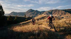
Scott Streater had an interesting article in E&E News yesterday about a new BLM policy on e-bikes.

The Bureau of Land Management is clamping down on the use of electric bikes in areas where motorized, off-highway vehicles are prohibited — concerning some outdoor recreationists but pleasing conservation groups worried about protecting natural resources.

At issue is BLM’s instruction memorandum, dated Aug. 1 and sent to all field offices, that walks back a Trump-era rule exempting e-bikes from off-road vehicle regulations, thus allowing them to be used in some cases on backcountry trails and other areas where motorized transport is generally prohibited.

BLM says in the latest memo that when it comes to authorizing the use of e-bikes in certain areas — such as on remote mountain and backcountry trails — it warrants the bureau taking a more “cautious approach” to regulation than what was outlined in the 2020 rule.

Specifically, the memo signed by Thomas Heinlein, assistant director of the National Conservation Lands and Community Partnerships directorate, requires BLM state, district and field offices to obtain his department’s approval “before using the e-bike rule to exclude e-bikes from the definition of off-road vehicle” or before authorizing “e-bikes on trails on which motorized vehicles are otherwise prohibited.”

Doing so “will allow BLM leadership to carefully consider the issues raised by application of the rule in site-specific circumstances,” the memo says.  The directorate “is better situated than individual state, district, and field offices to monitor new research on impacts and the compatibility of e-bike use on public land,” the memo says. It calls for the directorate to stay current on “relevant research” on e-bike use in the event that future studies indicate “e-bike use results in different — and potentially greater — impacts than what was assumed when the BLM promulgated the e-bike rule in 2020.”
The instruction memo requirements do not apply to people with disabilities who request “to ride an e-bike on trails where mechanized use is allowed and off-road vehicle use is otherwise prohibited,” it says.

************

So going to the memo itself..

Moreover, the National Conservation Lands and Community Partnerships Directorate is better situated than individual state, district, and field offices to monitor new research on impacts and the compatibility of e-bike use on public land. To that end, the Directorate will monitor the status of relevant research. Staying apprised of recent developments will allow the Directorate to know whether new research indicates that e-bike use results in different—and potentially greater—impacts than what was assumed when the BLM promulgated the e-bike rule in 2020.

What’s interesting about this to me is the idea of running certain decisions through Headquarters and requiring a centralized approval.  A person could argue that a centralized office would be better able than a field office to monitor “relevant research” on just about anything.

Second, it may be difficult for the BLM to enforce critical aspects of the e-bike rule. Under the rule, an e-bike can be excluded from the definition of off-road vehicle and, therefore, allowed on trails where off-road vehicle use is otherwise prohibited, only when the electric motor is not exclusively propelling the e-bike for an extended duration. Despite language in the rule’s preamble asserting that such enforcement challenges are not unique, this limitation, which is intended to help keep speeds down and prevent riders from venturing too far into the backcountry, may be difficult to police on remote, non-motorized trails.

I wonder if scarce BLM law enforcement resources are best employed checking to see that bikes are e-bikes or not on trails.   But if there’s no enforcement people on remote non-motorized trails, it really doesn’t matter exactly what the rules are.

Conservation groups praised the move, saying it’s needed to ensure that increased public access to more remote areas afforded by the motorized bikes does not trump resource protection. “We are pleased the BLM is taking this issue seriously and recognizes that a ‘cautious approach’ is needed in managing e-bikes, particularly e-mountain bikes, on public lands,” Judi Brawer, a wildlands attorney at the Southern Utah Wilderness Alliance, said in a statement. Brawer said that adding motorized mountain bikes “to already crowded trails necessitates the caution and further study provided for in this new guidance.”

So the problem is too many people? And yet the same groups often advocate for “protection” designations based on the fact that they attract more people and revenue to gateway communities.

I asked Scott which conservation groups exactly, and he replied in an email: “SUWA. Sierra Club, PEER, Pacific Crest Trail, Backcountry Horsemen Association, some hiking conservation group whose name escapes me.”

I guess there’s two questions for me here.. if you don’t trust District Managers to make the right decisions, why start with e-bikes?  One of my contacts pointed out that centralizing decisions like this was considered to be bad during the Trump Admin, and the local folks were thought to be better at making decisions.  And so it goes…

Firewise Coercion vs Cooperation?

“After the great fires in London in 1666 and Chicago in 1871, building codes started addressing the risks one building posed to adjacent buildings and the public,” from a nice summary of building codes history in Mother Earth News.

How many “great fires” will it take before we wise up to the fact that cooperation isn’t sufficient to protect communities from fires that ignite out-of-doors? As was the case with building codes, the insurance industry is taking the lead. But not by constructively developing model Firewise codes (e.g., for vegetation management and home design that resists exterior ignition) and urging state and local governments to adopt them. Instead, the insurance industry is taking a hike, refusing to underwrite homes in potential high-loss areas. In response, state and local governments are either coercing the insurance industry to underwrite or subsidizing insurance for the newly uninsured. Neither tactic addresses the underlying problem.

Unless and until governments adopt enforceable Firewise regulations to protect against catastrophic community loss, we will continue to suffer catastrophic community losses.

Why Weren’t Hawaii’s Firewise Websites Enough to Prevent Maui Tragedy?

Hawaii has several Firewise websites that seek to educate homeowners about best practices. The state has also written fire mitigation plans and developed fire risk maps. Notwithstanding these planning efforts, Lahaina was obliterated by a wind-driven wildfire. The catastrophe is likely to exceed 100 fatalities and cost billions to rebuild the town.

A series of vegetation-related events set the stage for this catastrophe. First was the 20th-century elimination of the native fire-resistant forest vegetation by pineapple and sugar cane plantations. Next was the abandonment of those plantations and their replacement by invasive grasses. Add in terrain-driven high winds common to parts of Hawaii plus seasonal drought and all that was missing was an ignition source, which has yet to be determined, but, once again, wind-downed power lines may prove to be the culprit.

After I made these observations last week on a firefighter’s website, which got me banned from the site (🤣), Sharon suggested I re-visit the topic here.

In my original comment on the firefighter site, I noted that Hawaii has no “Firewise-type program.” The firefighter blog’s owner responded to me with links to Firewise information websites. Although helpful, I explained to her that information is not a “program” that will move the needle at a community-wide level. Moving the needle requires enforceable building and vegetation codes, zoning, and ordinances, as I explained in a subsequent comment before being censored.

If it is to be effective, “Firewise” must be more than putting information on a website, doing analyses, drawing maps, and formulating plans. Firewise must also include on-the-ground actions. In Maui, that would have included replacing the invasive weeds with native species plantings. In their abandoned status, these former plantation lands are a time bomb — a deadly nuisance — that tragically blew up, as knowledgeable folks had warned for years. In other words, but for the invasive grasses, this tragedy would likely not have happened. Government is in the best position to require the former pineapple and sugar cane plantation owners to abate this nuisance. Unless and until that happens, the Lahaina tragedy will repeat itself elsewhere.

Mitigating the invasive grass threat would also have been much less expensive than wholesale Firewise refurbishment of Lahaina’s existing housing stock. Now, of course, Lahaina has the opportunity to replace its housing fire-wisely, with, one hopes, new and enforced building codes and zoning.

What Do Resort-y Parts of Hawaii, the Mountain West, Great Britain and Australia Have in Common? Housing Affordability and Displacement

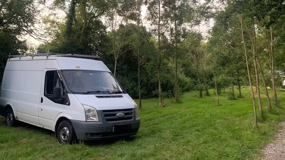
Summer Auty is living in her van because rents are so high in Frome (England)


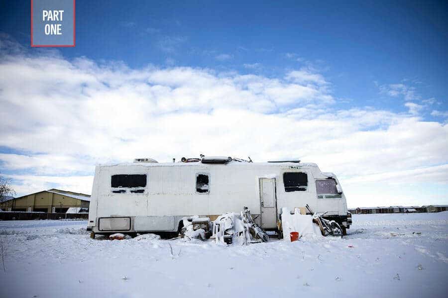
A RV stands on a street in Bozeman, Montana, in December 2022, a housing “fix” many locals are turning to as rents rise. Photo by Janie Osborne

I’m curious about gentrification, and whether residents of an area (Native or not) should some kind of right to continue to live there, given that it has become an area where young people are priced out of housing and costs of living.  You can think of say, Jackson in Wyoming. I don’t know the answer, but I’m raising it as a question. And would current natives have more of a right than new migrant low income people with jobs there?

We have our own Jacksons, Vails, and so on in the US, sometimes near federal lands, and the amenity migration plus tourism has been spreading post-Covid. Here’s one of many articles on that in Montana.

The Hawaiians have their own (at least Native Hawaiians according to this WaPo article)

The displacement of Native Hawaiians is a particularly acute concern now, as much of the island has been targeted for gentrification, driving up the costs of living and forcing many Native Hawaiians to move to mainland cities like Las Vegas.

And the short-term rental phenomena and displacement also occurs in England, as per this BBC story.

In nearby Bruton, the chair of the town council, Ewan Jones said the rise of holiday lets had taken many rental properties out of the market.

“We have the UK’s biggest farmhouse cheese manufacturer in this parish, you talk to them and their number one concern is ‘where do our workers live?'”

He said schools in particular were worried about the supply of homes their teachers and support staff could afford to live in.

This statement could be about Durango or any number of communities in the US… it’s just interesting this seems to be a common trend across many countries (at least those whose news is in English).

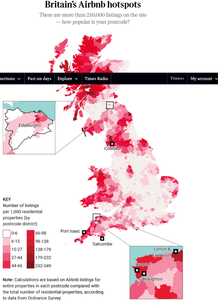
After I read this excellent article in the The Times Sunday Magazine, I went down a curiosity rabbit-hole on Airbnb and influences on housing availability. The Times has a six month deal for one pound.  Seems like this would be a great interactive map and story for the US.. I wonder if someone’s done it?

From the story..

Devon locals complaining about how Devon locals are being priced out of Devon — so far, so unsurprising. But in the past few years the focus of complaint has changed. The main threat used to be second home owners. In 2011 local councillors formed a steering committee to promote affordable housing and local jobs; their charter firmly stated that stemming the tide of second homes was a priority. But now that threat has been overshadowed by a new and more virulent one. The area has seen a huge, Silicon Valley-charged influx of Airbnbs. Of the 1,022 residential properties in Lynton’s EX35 postcode, 163 of them are available for short-term rental on Airbnb. That’s almost one in six properties, making it one of the most Airbnb’d places in the UK. But not the most.

Airbnb was originally presented as a pocket-money booster for people with a spare room — the company’s pitch to investors in 2008 was “book rooms with locals, rather than hotels”. But data compiled exclusively for The Sunday Times Magazine illustrates just how pervasive Airbnb has become in many of Britain’s most popular tourist areas. That the demand for holiday homes should be higher in these areas is to be expected, but the scale of the shift to short-term lets — and the knock-on effect this is having on villages, towns and cities and the people who try to live in them — is dramatic.

Here’s an article about how it works in Australia, with some interesting ideas..

Given holiday homes will remain an important part of tourism infrastructure in regional areas, could we make use of them in more strategic ways? For instance, during natural disasters or housing crises?

An estimated 65,000 people were temporarily displaced during the 2019-20 bushfires that ravaged the east coast. Some 3,100 houses were also destroyed, leaving around 8,000 people in urgent need of accommodation.

Similarly, over 14,000 homes were damaged in NSW by last year’s floods, and more than 5,000 were left uninhabitable.

A year later, many people in NSW continue to live in inadequate accommodation. Government-issued temporary homes, such as campervans and “pods”, are in woefully short supply.

Housing generally takes a long time to build, making it difficult to respond to such short-term increases in demand.

More strategic and creative use of the short-term rental stock might be the answer. We have seen some gestures by Airbnb and other platforms to support people displaced by disasters, but these responses have largely been ad hoc and uncoordinated.

When disaster zones are declared, Commonwealth and state governments could mandate and coordinate access to short-term rental accommodations for displaced residents and relief workers.

We could even extend such declarations during housing crises like the one we’re experiencing now, as the mayor of Eurobodalla on the NSW south coast has suggested. This would give governments time to deliver longer-term housing solutions in areas of heavy demand.

EPA, Rx Fires, and Smoke

This is interesting (thanks again for Nick Smith at HFHC for the link).  EPA press release:

EPA approves Washington’s Smoke Management Plan to allow strategic use of prescribed fires to manage forest health and protect air quality

Updated plan provides more flexibility for managing prescribed burning while continuing to minimize air quality impacts from smoke.

Contact Information
Suzanne Skadowski ([email protected])

206-900-3309

SEATTLE (August 10, 2023) – The U. S. Environmental Protection Agency has approved Washington State’s updated Smoke Management Plan under the Clean Air Act. The Smoke Management Plan regulates prescribed burning on forest land aimed at reducing fuel loading, restoring forest ecosystems, and potentially reducing the risk to communities from catastrophic wildfires, while minimizing air quality impacts from smoke.

“As wildfires become more frequent and severe, particularly here in the Northwest, we are working closely with our local, state, tribal and federal partners to help prevent, prepare for, and mitigate those risks and impacts,” said Casey Sixkiller, Regional Administrator of EPA’s Region 10 office in Seattle. “By increasing the flexibility in the tools and timing for prescribed burning, we can better prevent and reduce the health impacts of smoke from wildfires on our communities.”

Key revisions to Washington’s Smoke Management Plan are expected to modernize the approval process so that prescribed fire can be a more effective tool to reduce the risk of catastrophic wildfires while also preventing and managing air quality impacts.

“Prescribed burning is a critical component of DNR’s continued forest health work,” said Commissioner of Public Lands Hilary Franz. “Using ‘good fire’ to remove potential fuels safely and efficiently makes our forests and grasslands healthier and less susceptible to the explosive wildfires that have filled Washington’s summer skies with smoke the last decade. With this plan, we’ll be able to do the work we need to keep our skies and lungs clear.”

“In recent years, wildfire smoke has repeatedly blanketed Washington, taking an enormous toll on the health of our state’s communities,” said Heather Bartlett, Ecology’s deputy director. “This updated plan provides an important tool for preventing wildfire, and we’re pleased we were able to work with our partners to protect air quality and public health.”

Wildfire has had a serious impact on communities across Washington during the past decade with many large-scale wildfires impacting air quality. Prescribed fires are increasingly used as a land management tool to help reduce the likelihood of potentially catastrophic wildfires by reducing the buildup of unwanted fuels and strengthening ecosystems. Prescribed burning —the controlled application of fire to wildland fuels— is done under specific environmental conditions and protocols, confined to a predetermined area and on a limited intensity and scale required to attain forest land management objectives. The State anticipates increasing the application of prescribed fire in response to the increasing threat of wildfires in Washington.

The Department of Natural Resources has jurisdiction for prescribed burning on forest lands in Washington State, while the Department of Ecology is responsible for updating and implementing the Clean Air Act State Implementation Plan. EPA last approved the Washington Smoke Management Plan in 2003. Following significant wildfires, the Washington State Legislature directed the Department of Natural Resources to study prescribed burning practices and improvements needed to the Smoke Management Plan and to increase the pace and scale of prescribed burning to reduce fuel loads and help prevent catastrophic wildfire. Ecology submitted the updated Smoke Management Plan for review, approval, and inclusion in the State Implementation Plan in August 2022.

For more information on prescribed burns, restrictions and permits in Washington state, visit the Department of Natural Resources Burn Portal at: https://burnportal.dnr.wa.gov/

For wildfire smoke information in Washington state, including health risks, air monitoring and forecast smoke levels, visit Ecology’s Smoke and Fire Management page at: https://ecology.wa.gov/Air-Climate/Air-quality/Smoke-fire

The interagency Washington Smoke Blog provides also real-time information on current wildfire smoke conditions and wildfire updates at: https://wasmoke.blogspot.com/

~ ~ ~ ~ ~


Steve Ellis Talks About Using Retardants

Steve Ellis talks about retardants on behalf of the USFS retirees group, in a Jefferson Public Radio interview…. Almost 30 minutes. I haven’t listened to it yet. JPR’s July 24 interview with Andy Stahl is here.

When wildfires break out, one of the first tools is still the air tanker, dropping tons of red fire retardant into the path of the fire. The U.S. Forest Service is seeking a permit to use the red slurry under the Clean Water Act, the result of a lawsuit filed against the agency by Forest Service Employees for Environmental Ethics.

We recently spoke to the organization’s leader about the dangers of fire retardant, especially to waterways. Here we get a defense of the tactic from the National Association of Forest Service Retirees. Steve Ellis is the board chair of NAFSR and our guest, giving us an extended defense of the tanker planes and their payloads in firefighting.

Firefighters back off growing fires in dangerous dead forests north of Pagosa Springs in southwestern Colorado

From the Denver Post — thanks to Nick Smith at HFHC for the link.

Firefighters back off growing fires in dangerous dead forests north of Pagosa Springs in southwestern Colorado

Federal officials declared “full suppression” approach to 1,133-acre wilderness fire but cannot engage it for now

“There is no way to engage the fire because it is extremely deep in the wilderness. There are no roads. No trails. It is burning in extremely thick timber that is mostly standing dead and downed trees. It is extremely steep terrain. We’re not going to put firefighters at risk,” San Juan National Forest spokeswoman Lorena Williams said.

“We are developing plans for when the fire reaches terrain where we can engage it,” Williams said. “In areas surrounding the wilderness, we do have critical infrastructure — utility power lines, gas lines.”