Variable-Density Thinning Research and Virtual Tour

Kudos to the Stanislaus National Forest for its report that says “science shows that thinning and fuels treatments work” and a virtual tour of the project area on the Stanislaus-Tuolumne Experimental Forest in California. The link is to an press release that explains the science findings on variable-density thinning and provides a link to a virtual tour of the area. Note the warnings about the virtual tour taking a LONG time to load — it does, even with high-speed Internet. They recommend using the Chrome browser, which I did.

I haven’t viewed the entire tour yet, but the opening scenes show a dense stand that is very much in need of treatment — a fire there would be intense. It’ll have to be mechanically thinned before Rx fire can be used. The scene is representative of many, many sites in the Sierras. Similar conditions, with different species, exist across the western US.

Perhaps not coincidentally, the Stanislaus recently released the RoD for the Social and Ecological Resilience Across the Landscape (SERAL) project. A news article on the project explains that “The project is planned on an area that totals 118,808 acres of public and private lands that include 94,823 acres in Forest Service jurisdiction….”

The Stanislaus aims to use variable-density thinning (VDT) in the project area. VDT is controversial in the eyes of some environmental groups. For example, a coalition of groups convinced a federal court that VDT is highly controversial, scientifically, as proposed for the Crystal Clear Restoration Project in Oregon; the court agreed, and ruled that the Mt. Hood NF erred in using an EA. The forest had planned to do an EIS, but the White River Fire burned much of the project area in 2020.

On VDT in the experimental forest, the Stanislaus says, “What they found was that during a recent severe drought that killed over 147 million trees statewide, the two thinned treatments came through relatively unscathed, experiencing far less tree mortality than the adjacent unthinned areas. By reducing competition, the remaining trees had greater access to sunlight, water and the nutrients found in soils. They also found that the addition of prescribed fire is key to a more vibrant and diverse understory plant community, similar to what these forests once contained.”

This photo shows before and after conditions:

It will be interesting to see if enviro groups challenge the SERAL project. The news article says SERAL was “born from an ongoing partnership between the federal Forest Service, the collaborative Yosemite Stanislaus Solutions group, and Tuolumne County. Other partners include Sierra Pacific Industries, the Tuolumne River Trust, and the Central Sierra Environmental Resource Center in Twain Harte.”

In any case, I recommend taking the time to experience the virtual tour.


Science to Support the Wildfire Crisis Strategy

The USFS recently sent out an R&D Special Issue, “Science to Support the Wildfire Crisis Strategy.” Lots of science on topics of our recent discussions. I hope this format will work….


Researchers and Fire Managers Strengthen Ties
An issue titled Developments in Wildland Fire Research in Fire Management Today compiles the latest advances in managing fire, measuring fuels and smoke, co-producing science on prescribed fire and understanding how fire interacts with other disturbances.
New Comprehensive Resource on Past, Present and Future Fire Ecology
Over 70 experts, including Forest Service scientists, managers and external partners wrote a broad synthesis on fire ecology for every major forest type in the U.S. The book outlines management options for reducing wildfire risk while maintaining biological diversity and ecosystem integrity.
A Critical Analysis of Plans to
Restore Forest Resilience
As we ramp up forest management to historic levels, many may wonder if these efforts can effectively reduce wildfire risk to communities. And will these efforts also create landscapes that are resilient to disturbance? A research team including Forest Service scientists asked these difficult questions in a recent in-depth synthesis. The authors conclude that a range of proactive, science-based management activities will be needed to keep up with changing trends in climate and wildfire.
Using Forest History as a Guide for Future Resilience
Ideally, future forests will be tolerant of climate change and other disturbances. Figuring out what these forests should look like is tricky. A recent study by Forest Service scientists and partners found that between 1911 and 2011, dry forests in the western U.S. became six to seven times more crowded and average tree size shrank by 50%. Based on historical conditions, the authors suggest that the key to future resilience is promoting low density forests. This will reduce competition for resources among trees, allow them to grow larger and provide them with greater capacity to withstand disturbance.
Do Communities Trust Land Management Agencies?
To find out, Forest Service scientists surveyed five wildfire-prone communities in the western U.S. They learned that communities tended to trust more when they perceived competence and coordination among agencies. The authors suggest that managers focus on active communication, demonstrating competence and showing intent to act in the best interest of communities.
Delivering Smoke Science
Directly to People
The AirFire Research Team is part of a collaborative interagency program that studies wildland fire emissions, smoke and air quality. Their mission is to help public agencies and communities prepare for smoke impacts before wildfire occurs. They developed a real-time Smoke Map that is also available as a mobile app.
Wildfires are Becoming
More Active at Night
Forest Service scientists and partners used satellite imagery to monitor wildfire activity at night across the conterminous U.S. Between 2003 and 2020, they estimated a 20-50% increase in fire activity at night, which outpaced daytime increases. More intense and expansive night fire activity will likely accompany more large wildfires, posing additional danger to firefighters and communities.
When to Let Wildfires Burn?
One way to help restore fire-adapted ecosystems is to let wildfires do some of the work of prescribed fires. Deciding when not to fully suppress a wildfire is extremely complex, finds a recent review that includes a Forest Service co-author. Operational concerns and risk aversion were two important obstacles to managing wildfire in this way.

OSU research suggests Forest Service lands not the main source of wildfires affecting communities

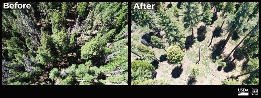
More research—this time by Oregon State, Colorado State, and the Forest Service’s Rocky Mountain Research Station—suggesting that the U.S. Forest Service and timber industry continues to bark up the wrong tree with a focus of logging on public lands as a means to protect communities from wildfire. This quote from Dr. Chris Dunn of Oregon State’s College of Forestry (who’s researcher areas are silviculture, fire, and forest health) was particularly interesting: “The Forest Service’s new strategy for the wildfire crisis leads with a focus on thinning public lands to prevent wildfire intrusion into communities, which is not fully supported by our work, or the work of many other scientists, as the best way to mitigate community risk.”

The following article was published by Oregon State University.

CORVALLIS, Ore. – Research led by Oregon State University shows that fires are more likely to burn their way into national forests than out of them.

The findings contradict the common narrative of a destructive wildfire igniting on remote public land before spreading to threaten communities, said Chris Dunn of the OSU College of Forestry.

The study, which looked at more than 22,000 fires, found that those crossing jurisdictional boundaries are primarily caused by people on private property.

It also showed that ignitions on Forest Service lands accounted for fewer than 25% of the most destructive wildfires – ones that resulted in the loss of more than 50 structures.

“In the old framing, public agencies bear the primary responsibility for managing and mitigating cross-boundary fire risk and protecting our communities, with their efforts focused on prevention, fuel reduction and suppression,” Dunn said. “This has been the dominant management approach of years past, which is failing us.”

The findings, published today in Nature Scientific Reports, follow by a few weeks the Forest Service’s release of a new 10-year fire strategy, Confronting the Wildfire Crisis. The strategy aims for a change in paradigm within the agency, Dunn said.

“We are long overdue for policies and actions that support a paradigm shift,” he said.

Scientists including Dunn and OSU’s Will Downing investigated 27 years of fires that crossed jurisdictional boundaries. The collaboration also included scientists from Colorado State University and the Forest Service’s Rocky Mountain Research Station.

Cross-boundary fires consumed just over 17 million acres during the study period of 1992 to 2019, and about half of the burned area was Forest Service land. The study area covered almost 141 million acres across 11 states and included 74 national forests.

Of all ignitions that crossed jurisdictional boundaries, a little more than 60% originated on private property, and 28% ignited on national forests. Most of the fires started due to human activity.

“The Forest Service’s new strategy for the wildfire crisis leads with a focus on thinning public lands to prevent wildfire intrusion into communities, which is not fully supported by our work, or the work of many other scientists, as the best way to mitigate community risk,” Dunn said.

“A substantial portion of the wildfire problem is a community destruction problem,” added Michael Caggiano of Colorado State. “The Forest Service can contribute to an advisory or facilitation role to address the home ignition zone, including fire resistant design and zoning, and fuels management on private lands, but states, local government and homeowners are better positioned than the USFS to manage those components of wildfire risk.”

A paradigm shift that could mitigate wildfire risk would begin with the recognition that the significant wildfires occurring in western states is a fire management challenge with a fire management solution, not a forest management problem with a forest management solution, Dunn said.

“The only way we are going to address the wildfire problem on large public lands at the scale of the challenge is through the effective and efficient management of wildfires over the long run,” he said.

Dunn said that means allowing some fires or portions of fires to burn to provide risk reduction and ecological benefits, identifying and preparing locations where suppression is likely to be effective, and developing strategies to rapidly distribute resources to where they are most needed and can do the most good.

“Our research has significant potential to inform and guide development of effective cross-boundary risk mitigation strategies, including identifying where and how work on the ground can be most effective,” he said. “The main source of our communities’ exposure to wildfire risk is clearly not our national forests.”

The study showed that in many cases, national forests were a net receiver of cross-boundary wildfire rather than a source, and that those fires tend to happen in areas with higher densities of roads and people.

Dunn credits the Forest Service for accepting the modern realities of wildfire and for embracing collaborative governance and cross-boundary partnerships. He added that managing fire in multijurisdictional landscapes has become a centerpiece of wildfire strategic planning and that evidence suggests fire transmission across boundaries will continue to increase.

“As the Forest Service’s strategy moves forward, we think there could be opportunities to learn from what their state partners are doing, such as the more comprehensive policies passed in Oregon in 2021,” he said. “Oregon’s omnibus wildfire bill is a science-driven approach that recognizes the shared responsibility we all have in adapting to the fire environment.”

The legislation requires those homes at greatest risk to mitigate at the home ignition zone and also addresses landscape resilience and improved wildfire response.

Dunn calls it “the type of comprehensive policy we need to address the multitude of impacts wildfires have on communities, ecosystems, industry, etc. It recognizes that the Forest Service is neither the sole source of the problem nor the sole solution to the problem, but rather one of many pieces to a paradigm shift society needs to make.”

Matthew Thompson and Karen Short of the Rocky Mountain Research Station also took part in the cross-boundary fire study, which was partially funded by the Forest Service.

Student Questions of the Day: Books About the Forest Service and Resources for Graduate Programs

One of the original reasons for The Smokey Wire was to help students.  So a student asked these questions, and I’ll put them out to the The Smokey Wire community.

– Do you have any book recommendations that relate to FS culture, planning, or policy? I am currently reading The Bitterroot and Mr. Brandborg.
– Do you know of any good resources for looking into graduate programs, specifically in forestry/ land use planning fields?
Of course, I have to put in a plug here for Steve Wilent’s 193 Million Acres, with chapters by yours truly and other TSW contributors. Steve, maybe you have a list of chapters and authors for that book, as well as thoughts on other books?
Also, I think that professional societies such as SAF might play some kind of role with resources for graduate programs, but don’t know for sure.

Western Governors’ Association: Working Lands Workshop, Task Force on Collaborative Conservation, and Interior West Maple Sugar?


Three interesting items from the Western Governors Association:

Working Lands Webinar.  February 23-24 in Boise, but is livestreamed (and recorded). Anyone can register.  Some interesting stuff on the agenda. If you’re interested, you’re invited to watch and write up your observations for a Smokey Wire post. These are always interesting to me as they often have speakers with on-the-ground knowledge of issues and solutions.  Also the atmosphere is generally “let’s all work together” rather than enemy-finding. At the ones I’ve been to, I was allowed to ask questions of the speakers.

New Task Force with Interior, Ag and States.  This seems like a good idea.  There is a Wildfire Commission in the new infrastructure bill, but it’s got kind of a federal-esque makeup.  It sounds like their might be some overlap between these groups re: fire resilience/mitigation.

The Task Force will serve as a forum for federal, state, and territorial representatives to collaboratively and effectively respond to the land, water and wildlife challenges facing Western landscapes through shared expertise and dialogue, strategic resource and capacity coordination, information and data sharing, and joint problem-solving. The Task Force will be essential to strengthening this state/territory-federal collaboration as local, state and federal leaders implement the recently enacted Infrastructure Investment and Jobs Act, which contains historic investments in wildlife restoration, drought mitigation, and wildland fire resilience.

This is from the WGA news roundup: USDA investing in helping build a maple sugar industry in the Interior West:

Sun said there are programs also looking into producing maple syrup in other regions of the U.S., like the Midwest and Pacific Northwest, “but they (didn’t) have any other project in the Intermountain West until this opportunity.”

So now, this group of academics and businesses will lead both research and outreach in the region. That includes researching which tree species in the Mountain West provide the best syrup, and when people should tap them.

They’re also providing workshops and working with landowners to teach people how to tap trees. Upcoming workshops on tapping trees in the West can be found here. They’re only in Utah for the rest of this year, but they expect to do more in the next few years.

However, for those who are enthusiastic about tapping trees, make sure you know who owns those trees and you get permission. When he started out, Knudson decided to tap trees near his home in Missoula, and he said, “I tapped the city trees, and so they had a conniption fit a little bit.”

So now he seeks out privately-owned trees, and makes sure they’re healthy and not over-tapped.

Here’s a cool video.

Planning for Future Climate by Forest

I just stumbled on a new (I think) storymap from the USFS, Climate by Forest. It’s “A tool for exploring climate change information on National Forest System lands.”

“Using the first version of Climate By Forest, forest planners could obtain climate change graphs and data files with just a few clicks. However, they still had to perform statistical analyses on the data to test whether projected changes would lead to a significant departure from historical conditions. This step required days to weeks of a climate specialist’s time to find, process, and reformat data files. To resolve this, developers incorporated the relevant statistical methods into the tool, enabling managers for every unit in the lower 48 states to access projections and the relevant statistical documentation for their plans from Climate By Forest in a matter of minutes.”

Here’s an example using the Columbia River Gorge National Scenic Area:


Best available mature science

This paper on ocean acidification has an element that is relevant for forest planning and litigation, and specifically the definition of “best available science.”

Ocean acidification has received much attention in the press, such as in a 2009 NT Times article, “Rising Acidity Is Threatening Food Web of Oceans, Science Panel Says.” The Times wrote that, “Now an international panel of marine scientists says this acidity is accelerating so fast it threatens the survival of coral reefs, shellfish and the marine food web generally.”

This month a study reported that a “Meta-analysis reveals an extreme “decline effect” in the impacts of ocean acidification on fish behavior.” PLoS Biol 20(2): e3001511. https://doi.org/10.1371/journal.pbio.3001511

A press release says the paper “demonstrates that the apparent severity of ocean acidification impacts on fish behaviour, as reported in the scientific literature, has declined dramatically over the past decade.”

The press release includes this passage (emphasis added]:

The researchers used meta-analysis to analyse trends in reported effects of ocean acidification on fish behaviour in studies published from 2009-2019. While early studies reported extremely clear and strong effects, the magnitude of those impacts has decreased over time and have been negligible for the past five years.

“A textbook example of the decline effect”, explains Dr. Clements, lead author of the study. “The decline effect is the tendency for the strength of scientific findings to decrease in magnitude over time. While relatively well-recognized in fields like psychology and medicine, it is lesser known in ecology—our study provides perhaps the most striking example of it in this field to date.”

To determine what might have caused the decline effect in their meta-analysis, the authors explored numerous biological factors, but found that biological differences between studies through time could not explain the results. Instead, common scientific biases largely explained the decline effect.

“Science often suffers from publication bias, where strong effects are selectively published by authors and prestigious journals”, says co-author Prof. Jutfelt. “It’s only after others try to replicate initial results and publish less-striking findings that true effects become known. Our analysis shows that strong effects in this field are favorably published in high impact journals.”

Maybe forest planners, litigants, and courts ought to use the “best available mature science,” not necessarily the latest science.

“Operational resilience” in western US forests

Here’s a new paper that will no doubt be controversial: “Operational resilience in western US frequent-fire forests.” The full text is here. Sounds innocuous, but a Bloomberg article about the paper summarizes: “To Save Western U.S. Forests, Cut Them Way Back, Study Suggests.” This may sound radical, but the consequences of not doing this are clear, according to the authors including some well-known researchers: Malcolm P. North, Ryan E. Tompkins, Alexis A. Bernal Brandon M. Collins, Scott L. Stephens, and Robert A. York:

“The first two decades of the new century have demonstrated that disturbance complexes including drought, insect epidemics, and landscape-level, high-severity fire will be stressing and in some places, type converting dry, western U.S. conifer forests.”

USFS forest planners ought to take this into account when looking at desired future conditions.

Abstract:

With the increasing frequency and severity of altered disturbance regimes in dry, western U.S. forests, treatments promoting resilience have become a management objective but have been difficult to define or operationalize. Many reconstruction studies of these forests when they had active fire regimes have documented very low tree densities before the onset of fire suppression. Building on ecological theory and recent studies, we suggest that this historic forest structure promoted resilience by minimizing competition which in turn supported vigorous tree growth. To assess these historic conditions for management practices, we calculated a widely-used measure of competition, relative stand density index (SDI), for two extensive historical datasets and compared those to contemporary forest conditions. Between 1911 and 2011, tree densities on average increased by six to seven fold while average tree size was reduced by 50%. Relative SDI for historical forests was 23–28% of maximum, in the ranges considered ‘free of’ (<25%) to ‘low’ competition (25–34%). In contrast, most (82–95%) contemporary stands were in the range of ‘full competition’ (35–59%) or ‘imminent mortality’ (≥60%). Historical relative SDI values suggest that treatments for restoring forest resilience may need to be much more intensive then the current focus on fuels reduction. With the contemporary increase in compounding stresses such as drought, bark beetles, and high-severity wildfire, resilience in frequent-fire forests may hinge on creating stands with significantly lower densities and minimal competition. Current management practices often prescribe conditions that maintain full competition to guide development of desired forest conditions. Creating stands largely free of competition would require a fundamental rethinking of how frequent-fire forests can be managed for resilience.


Less than a penny a day: New USFS and BLM livestock grazing fees announced

If you are a public lands rancher in the American West, what’s the daily cost for your privilege to graze your private domestic sheep on U.S. Forest Service or Bureau of Land Management administered lands?  Less than a penny a day.

If you graze cows on federal public lands, the grazing fee per day per cow jumps up to around 3 cents per day.

Keep in mind that livestock grazing is authorized on nearly 250 million acres of federal public lands, including authorized within over 25% of all designated Wilderness acres in the lower 48 states. The cost of livestock grazing on native wildlife and clean water are well documented.

Below is a press release from Western Watersheds Project:

For immediate release: Feb. 1, 2022 

HAMILTON, Mont. – Today, the Bureau of Land Management and the U.S. Forest Service announced the fee for grazing on federal public lands in 2022: a mere $1.35 per cow/calf pair per month (also called the animal unit month, or AUM), the lowest possible fee allowed under a Ronald-Reagan-era Executive Order.

“The absurdly low fee paid by commercial beef cattle producers to graze public lands flies in the face of this Administration’s commitments to conservation, biodiversity and addressing the impacts of climate change,” said Josh Osher, Public Policy Director for Western Watersheds Project. “President Biden should immediately rescind Reagan’s Executive Order and establish a fee that reflects the true costs of public lands grazing.”

Despite contributing only 2-3 % of all the beef consumed in the United States, commercial grazing is one of the most heavily subsidized activities on public lands.  The program costs taxpayers a minimum of over a billion and half dollars every 10 years, and the minimal fee recoups just one-tenth of the cost of its administration. The cost to beef producers to feed their stock on public lands is substantially less than the cost to feed a pet hamster each month.

“It’s a great deal for the beef industry, but it’s a horrible deal for the American public because of the compounded costs of plant and animal extinction, fouled waterways, increased risks of wildfire, ongoing predator killing, and the irreplaceable cultural resources being trampled to bits,” said Osher.

The grazing fee is based on a temporary formula set in 1978 and continued through Executive Order in 1986. The fee was $2.31 per AUM in 1981, the highest fee ever charged, which adjusted for inflation would be the equivalent of $7.09 today, more than five times the current fee. Lease rates for private pastureland in the Western U.S. average over $20 per AUM.

“Beef producers on public lands are the only tenants in the country whose rents stay low, year after year,” remarked Osher. “The livestock industry is getting a sweet deal to stay on public lands while many people in the country struggle to find affordable housing.”