This morning I got an email from U.S. Forest Service Research News, which including a link to this new research from the USFS and partners concerning wildfires in California.
While the research may be surprising to some, it’s not at all surprising to many of us who have said the same thing going back a few decades now. We’ve had perhaps over a hundred debates about this on the blog over the years. Heck, Dr. Jack Cohen’s research documented much of this going back into the 1980s, if not even earlier. Richard Halsey and his California Chaparral Institute have been also talking about these issues for at least 20 years. And those of us who’ve been branded as “environmental terrorist groups” – and blamed for California wildfires by the likes of former Interior Secretary Ryan Zinke – have been also trying to get the public and policy makers to understand the dynamics at play for decades as well.
Remember, it’s been very common for politicians from through the country (but especially the West) to use wildfires in California as the reason why we need to dramatically increase logging on our public lands by systematically weakening bedrock environmental laws. While that may make for good politics when people turn on their TV’s and see flames, it doesn’t make for good policy that will protect communities, firefighters and save lives and money.
Most California Fires Occur in Area of Wildland-urban Interface with Less Fuel and More People
Madison, WI, September 24, 2019 – In California, the state with more building destruction by wildfire than all of the other states combined, new research by a U.S. Department of Agriculture Forest Service scientist and University of Wisconsin-Madison partners found something surprising. Over nearly three decades, half of all buildings destroyed by wildfire in California were located in an area that is described as having less of the grasses, bushes and trees that are thought to fuel fire in the wildland-urban interface, or WUI.
The study by H. Anu Kramer with Forest Service scientist Miranda Mockrin and colleagues, “High wildfire damage in interface communities in California,” notes that a portion of the WUI defined as “interface” and characterized by having more homes but relatively little wildland vegetation experienced half of the building losses due to wildfire but composed only 2 percent of the total area burned by the wildfires assessed in the study. The study was recently published in the International Journal of Wildland Fire and is available at: https://www.nrs.fs.fed.us/pubs/58348
California’s expansion of housing within and adjacent to wildland vegetation is not unique; the most recent assessment shows that the WUI now includes about one-third of homes in the United States. As wildfire management has become more complex, costly and dangerous, defining what constitutes WUI and defining more specific types of WUI has become more important as local communities strive to apply resources and policy-decisions where they will be most effective in saving lives and property.
The Federal definition of WUI describes two specific areas: “interface” WUI includes developed areas that have sparse or no wildland vegetation, but are within close proximity of a large patch of wildland. “Intermix” WUI, on the other hand, is defined as the area where houses and wildland vegetation directly intermingle. Both are separate from “rural” areas, which may be characterized by agricultural land and low-density housing and development (less than 1 house per 40 acres).
“Our findings show that WUI areas do experience the vast majority of all losses, with 82 percent of all buildings destroyed due to wildfire located in the WUI,” Mockrin said. “We were surprised to find 50 percent of all buildings lost to fire being destroyed in the interface portion of the WUI, however. Many risk reduction plans focus on natural vegetation fueling fire, but in the interface WUI where so much of the destruction is occurring, we have to consider finer-grained fuels such as wood piles, propane tanks, and cars.”
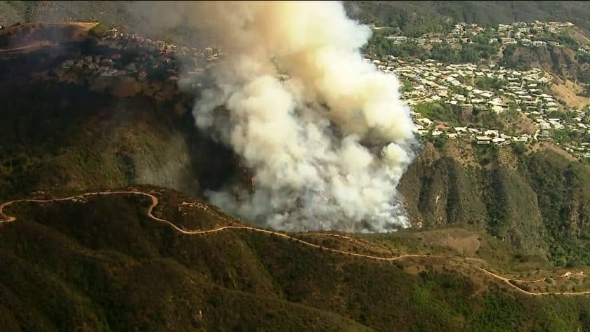
Study findings suggest that wildfires are still rare in urban areas. The Tubbs fire that struck Santa Rosa, Calif., in 2017 was similar to other California wildfires in that the majority of buildings lost in the fire were located in the WUI; however, the Tubbs Fire was unique in having 25 percent of all destruction occurring in urban areas. In comparison, 4 percent of destruction occurred within urban areas in other California fires. Other recent and highly destructive fires, including the 2018 Carr, Camp and Woolsey fires, included no urban area within their perimeters, exemplifying the rarity of the Tubbs’ building destruction in urban areas.
“Although the Tubbs fire was not the norm, it seems like every fall there is a new record-setting fire in California, with three of the five most destructive fires in state history having burned in the last 5 years and the deadliest California fire (the Camp fire) burning last year,” Kramer said. “These fires are fueled by the homes themselves, landscaping, and other man-made fuels that are seldom included in the fire models that are used to predict these fires. Our work highlights the importance of studying and mitigating the fuels in these interface WUI areas in California where most of the destruction is occurring.”
In addition to solidifying definitions of interface and intermix WUI so communities can address their different attributes in wildland fire planning, researchers suggest that fire behavior models should be revisited.
The study was co-authored by Volker Radeloff of the University of Wisconsin-Madison and Patricia Alexandre of the University of Lisbon.