Balanced Post-fire Treatments in the Rim Fire

I ran across this excellent article from  Eric Holst, Senior Director of the Environmental Defense Fund’s “working lands program”.

Here’s the link: https://www.edf.org/blog/2014/02/18/after-rim-fire-surprising-role-salvage-logging

P9132046-web

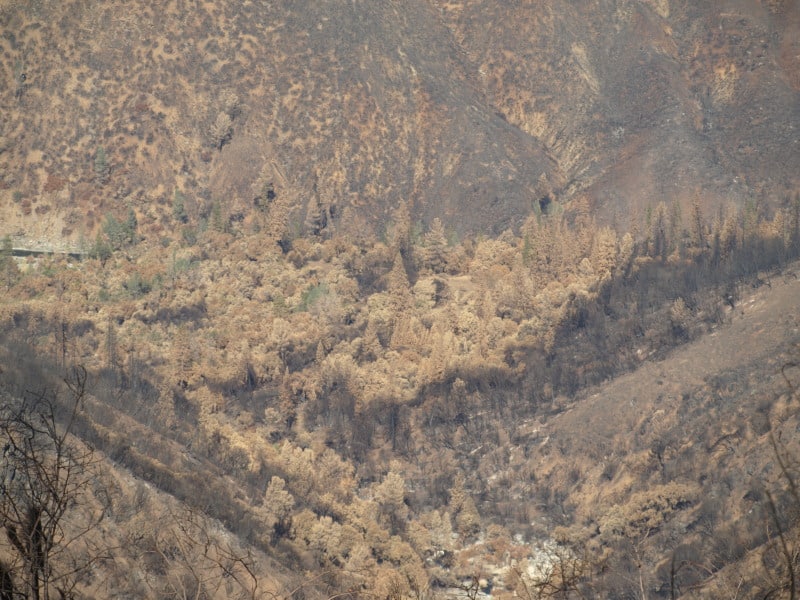
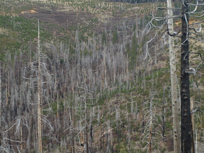
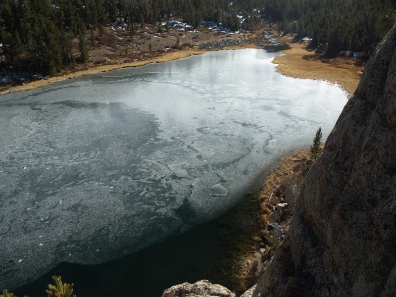
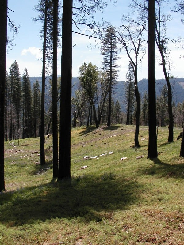
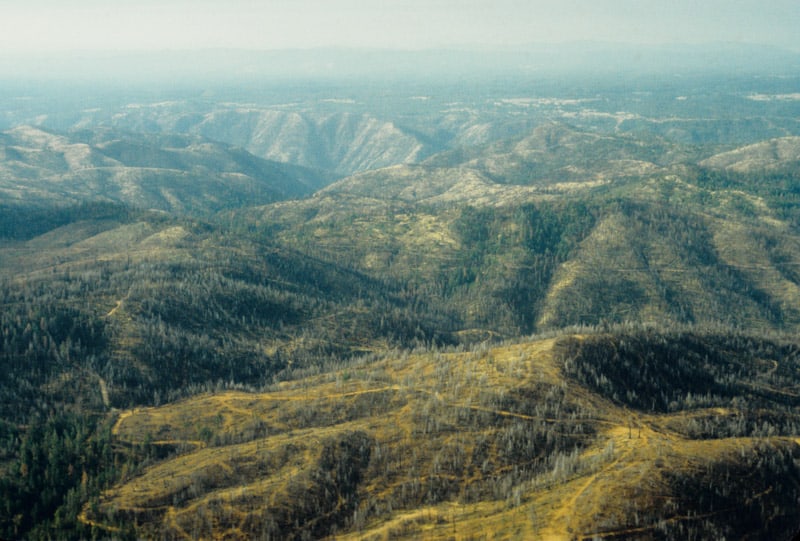
This picture is a view looking down into the Tuolumne River Canyon, from the “Rim of the World” overlook. Down there is where the fire started. I’d bet the spin on this wildfire would be VERY different if it was ignited by lightning.

Holst is showing some excellent judgement in looking at the bigger picture of the realities of the Rim Fire, seeing that “letting nature take its course” isn’t the way to go on every burned acre.

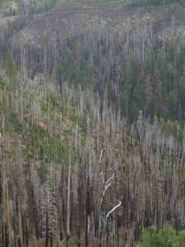
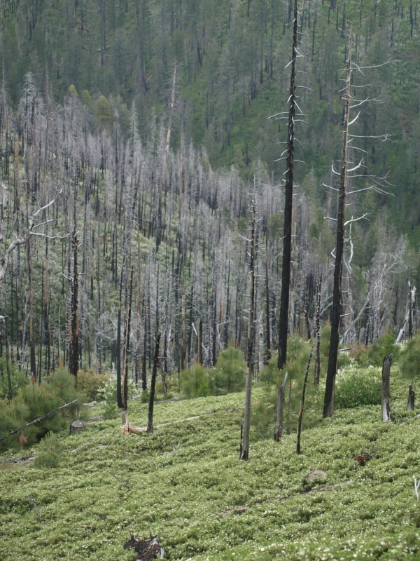
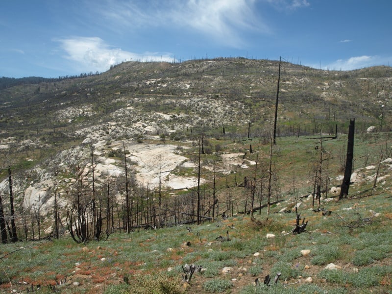
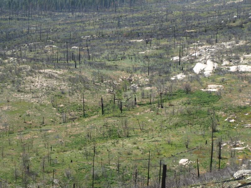
The Forest Service recently proposed to conduct salvage logging – removal of dead trees – on about 30,000 of the 98,049 acres of high intensity burned area and remove hazard trees along 148 miles of high use road in the burn perimeter. While it may seem counterintuitive for a conservationist to do so, I support this effort. In the high intensity areas, the Rim Fire burned so hot that it not only killed every tree but the top inch or two of soil with critical soil microfauna, and seed stocks were also sterilized. Fire of this intensity has been relatively rare in the moist middle elevations on western slopes of the Sierra Nevada and the native forests are not adapted to bounce back from this type of fire.

There are also some “interesting” comments, and a hint of “eco-bickering”. In those comments is also a return of the “Chapparalian”, using his actual name (instead of one of his many pseudonyms and even fake names). There are also some other interesting names commenting about these issues. John Buckley, a local leader of an environmental group comments with an open mind and a dose of reality. Others continue to spout the misguided idea that leaving the Rim Fire alone is the only way to go. Some commenters talked about the reality that we have plenty of BBW habitat, protected within the National Park. One reality not covered is that re-burns cause extensive damage that is very difficult to recover from, especially in areas left to “recover on their own”.

I still see that post-fire management is essential to getting big trees back on the land. We already have site-specific evidence that forests didn’t return when post-fire management was excluded, 40 years ago. We ended up with old growth brushfields, and a few stunted trees. Those old brushfields burned at moderate intensity. We have a big variety of landscapes, with differing burn intensities and site-specific conditions. This partial comment is spot-on, regarding these facts

It is interesting to see how many comments Eric’s post attracted from authors who are vehement that absolutely nothing except ‘let nature takes its course’ on National Forest lands. Since we have 100,000 acres of National Park land for that experiment, it would be more interesting to apply some other options on the National Forest lands. In the climate change debate, we continue to witness the rapid expansion of vocal people so sure of their own story that they refuse to even consider the possibility that it is worth learning more about the changing earth. Hopefully, this fate will not befall the response to the Rim Fire.

It seems pretty clear to me that a few open-minded people from both sides are seeing the realities of the Rim Fire, and its future.

Power Fire 2014

We’ve seen pictures of the Power Fire, on the Eldorado National Forest, before. I worked on salvage sales until Chad Hanson won in the Ninth Circuit Court, with issues about the black-backed woodpecker. The court decided that the issue needed more analysis, as well as deciding that the Forest Service’s brand new mortality guidelines were “confusing”. From these pictures, it is very clear to see that those mortality guidelines were way more conservative than they maybe should have been.

P9262156-web

As you can see, in this finished unit(s), there were ample snags available for birds to use, despite multiple cuttings, due to the increased bark beetle activity, during the logging. No one can say that they didn’t leave enough snags, (other than the Appeals Court). These pictures are very recent, shot last month.

P9262142-web

This picture amused me, as I put this sign up back in 2005. Plastic signs last much longer than the old cardboard ones.

P9262128-web

Here is another view of the area, chock full of snags, well beyond what the salvage plans asked for, to devote to woodpeckers and other organisms that use snags. People like Chad Hanson want more high-intensity wildfires, and more dead old growth. It is no wonder that the Sierra Club decided he was too radical, even for them.

Edit: Here is the link to a previous posting from almost 2 years ago, with pictures. https://forestpolicypub.com/2012/05/28/the-power-fire-six-years-later/

The East Side of the Sierra Nevada

I recently took a trip with my brother, as he wanted to try out my old digital camera. There is an abundance of “protected areas” here (including Wild Willies Hot Springs), and timber projects have been gone for about 20 years, now. Below is the Mono Lake Tufa Preserve, a fee-area which accepts the Park Service passes. There is a nice boardwalk down to the lake shore, paved parking and bathrooms.

P9111546-web

Turning off Highway 395, at Tom’s Place, there is easy access to the John Muir Wilderness. We took a short hike and found this really nice overlook to one of the many lakes close to the trailhead. Despite the lack of snow, there is no lack of cold, making persistent ice on the lake. This watershed extends up to 13,700 feet.

P9101347-web

I have visited North Lake, before, back in the mid-80’s, during a three-day ski mountaineering trip. This road has easy access to Paiute Pass and the nearly-14,000 foot Mount Humpreys, west of Bishop. This road has three forks, each of which provide access to the Sierra Crest (and hydro locations).

P9101488-web

More of my adventure, including Yosemite National Park, at www.facebook.com/LarryHarrellFotoware

Vintage Yosemite Photo

I’ve been digging through my old Kodachrome slides, and I found this view of the Tuolumne River and Poopenaut Valley, within Yosemite National Park. This area burned in the Rim Fire, and it is representative of what lies below, in the Stanislaus National Forest. Of course, little of this would even be worth salvaging, even it is wasn’t in the National Park. You might notice the abundance of digger pines, even on the north-facing slopes. This is the beginning of an impressive canyon, and it becomes a Wild and Scenic River, when you reach the Park boundary. Of course, very little fuels work could have been done, within this awesome canyon. However, fuelbreaks could have been installed all along the edge of this canyon, knowing that there would eventually be an ignition, within the canyon. Lightning fires happen all the time in this portion of the Sierra Nevada. I really want to get in here and re-visit these spots, for some repeat photography.

Poopenaut-web

American “Jungle”?

While I am waiting for a delivery, so I can complete the pieces of art for an upcoming show, I dug up this old picture of a dogwood tree, in South Carolina. Indeed, some parts of the South seem like jungle, especially when you include the kudzu and greenbriar. I was on assignment, back in 2003, to inspect forest inventory plots (in advance of thinning projects) on the Sumter National Forest. I also did plots, myself, when all inspections were completed. I made a species list, and it included 40 different harwdood species, including 20 different oaks, and only 3 conifers.

dogwood_bark-web

I had to dredge up all that 25 year old Dendrology information on trees I had never seen before. Luckily, I didn’t have to split out some of those species, including hickories. It was a challenge I welcomed, and was schooled by a patient detailer who I clicked with, right away. Yes, they still use “metes and bounds”, down there. Being from the west coast, there was some culture shock but, “Southern Hospitality” definitely isn’t a myth! However, “Barbecue” is quite a different concept there, and good pizza and Mexican food is hard to find.

www.facebook.com/LarryHarrellFotoware

Take a Breath, See the Sights and Enjoy the Scenery

With all the controversial crossfires going on, here, lately, and the angst that goes along with it, we need to be reminded that most of us want the same outcomes and benefits for our forests and public lands.

Let us take a small break here, and smell the ….. errr…. deer poop.

P9090806-web

My last trip to Yosemite, before the Rim Fire started, was to Tuolumne Meadows, a high elevation “Mecca” for enlightened Yosemite lovers. I’ve seen big bucks here before but I didn’t think there was such a big herd of these “muleys”, who migrate over the top of the Sierra Crest from the Mono Lake area. I had seen and “shot” about 20 nice bucks before I ran into this group. For the whole day, I saw almost 40 bucks, and some of them were rather tame. In all my years of working in the woods, in many different National Forests, in many different states, I’ve never seen such a rack on a buck. I’m not a hunter so, is a buck like this very common? I’m sure that “trophy hunters” wouldn’t hesitate to shoot this guy but, I prefer to “shoot” him, this way.

Why We Need to Salvage and Replant the Rim Fire

Greg asked why we should bother with salvage logging on the Rim Fire, and I tried to explain how bear clover would dominate landscapes. He also seemed confused about modern salvage projects, here in California. Everything, here in California, is fuels-driven, as wildfires happen up to 13 times per century, in some places in the Sierra Nevada.

This picture shows how dense the bear clover can be, blocking some of the germination and growth of conifer species. Additionally, bear clover is extremely flammable and oily, leading to re-burns. This project also included removing unmerchantable fuels, including leaving branches attached. Yes, it was truly a “fuels reduction project”. You might also notice how many trees died, from bark beetles, after this salvage sale was completed. Certainly, blackbacked woodpeckers can live here, despite the salvage logging. Hanson and the Ninth Circuit Court stopped other salvage sales in this project, in favor of the BBW.

P9256073-web

When you combine this bear clover with a lack of fire salvage and chaparral brush, you end up with everything you need for a catastrophic, soils-damaging re-burn and enhanced erosion, which will impact long term recovery and the re-establishment of large tree forests. Actually, there has already been a re-burn within this project since salvage operations in 2006. Salvage logging greatly reduced that fire’s intensity, as it slicked-off the bear clover, but stayed on the ground. Certainly, if the area hadn’t been salvaged, those large amounts of fuels would have led to a much different outcome.

Now, if we apply these lessons to the Rim Fire, we can see how a lack of salvage in some areas within the Rim Fire will lead to enhanced future fires, and more soils damages and brushfields. When the Granite Fire was salvaged in the early 70’s, large areas were left “to recover on their own”, in favor of wildlife and other supposed “values”. When I worked on plantation thinning units there, those areas were 30 year old brushfields, with manzanita and ceanothus up to eight feet high. Those brushfields burned at moderate intensity, according to the burn severity map. Certainly, there were remnant logs left covered by those brushfields, leading to the higher burn severity. It was the exact same situation in my Yosemite Meadow Fire example, which as you could see by the pictures, did massive damage to the landscape, greatly affecting long term recovery. Here is the link to a view of one of those Rim Fire brushfields, surrounded by thinned plantations.

https://maps.google.com/maps?hl=en&ll=37.999904,-119.948199&spn=0.003792,0.008256&t=h&z=18

I’ve been waiting to get into this area but, I expect the fire area will remain closed until next year. The plantations were thinned and I hear that some of them did have some survival, despite drought conditions and high winds, during the wildfire. In this part of California, fuels are the critical factor in wildfire severity. Indians knew this, after thousands of years of experience. They knew how to “grow” old growth forests, dedicating substantial amounts of time and energy to “manage” their fuels for their own survival, safety and prosperity. Their preferred forest included old growth pines, large oak trees, very little other understory trees, and thick bear clover. Since wildfires in our modern world are a given, burning about every 20 to 40 years, we cannot be “preserving” fuels for the next inevitable wildfire.

We need to be able to burn these forests, without causing the overstory pines to die from cambium kill, or bark beetles. That simply cannot be done when unsalvaged fuels choke the landscape. We MUST intervene in the Rim Fire, to reduce the fuels for the next inevitable wildfire that WILL come, whether it is “natural”, or human-caused. “Protected” old growth endangered species habitats may now become “protected” fuels-choked brushfields, ready for the next catastrophic wildfire, without some “snag thinning”.  We cannot just let “whatever happens”, happen, and the Rim Fire is a perfect example of “whatever happens”. Shouldn’t we be planning and acting to reduce those impacts, including the extreme costs of putting the Rim Fire out, and other significant human costs? Re-burns are a reality we cannot ignore, and doing nothing is unacceptable. Yes, much of the fire doesn’t have worthwhile salvage volumes, and that is OK but, there are less controversial salvage efforts we can and should be accomplishing.

Here is an example of salvage and bear clover, six months after logging with ground-based equipment. This looks like it will survive future wildfires. You can barely even see the stumps, today! The bear clover has covered them.

clean_salvage-06

The Future of the Rim Fire?

These are 2011 views of the A-Rock/Meadow Fire re-burn, within Yosemite National Park, after 4 years of “recovery”. The actual “recovery” time is now at 24 years, since the original A-Rock Fire raged through majestic old growth. You can barely make out the road into Yosemite Valley. You might also notice a lack of any conifer trees growing back.

Meadow-fire-2001-web

Even fire-adapted oak trees are doing very poorly, and the large snags from the previous stand, before the A-Rock Fire in 1989, are completely gone. Remember, no salvage logging happened away from roadside hazard trees.

OLYMPUS DIGITAL CAMERA

This is how the Sierra Nevada “recovers” from catastrophic wildfires. It can take hundreds of years to re-grow a forest, without help from humans. Indeed, Yosemite is a living laboratory, and it is clearly showing us some “lessons learned”. It is also clear that any Yellowstone recovery parallel to Sierra Nevada wildfires is not supported by actual results.


Aerial view of the 1987 Complex Fire Salvage

I took this shot while flying with a Forest Service buddy in 1989.

Aerial-1987-complex-web

I am pretty sure that this is Forest Service land, near the Groveland Ranger District office. When I worked there in 1990, the Timber Management Officer was still angry at the less-than-aggressive post-fire salvage efforts that allowed so many “brain dead” trees to die and add to the fuel loading. I’m sure that all those dead trees had some green needles on them as salvage logging was proceeding. As you can clearly see in the photo, there are PLENTY of snags left in this HUGE wildfire zone. This isn’t even where the fire burned hot. The subsequent bark beetle bloom spread northward, chewing up forests more than 100 miles away. On the Eldorado, our Ranger District harvested 300 million board feet, between 1989 and 1992, of dead and dying timber from the severe bark beetle infestation. We were lucky, able to slide our EIS into place before the litigators could gather their case together. The Tahoe National Forest was too slow, and lost 2 years worth of salvage logging opportunities, turning merchantable dead trees into future wildfire fuels.

The Lake Tahoe Basin Management Unit was also hard hit, and slow to react. Here is a 1990 view of the north end of the Lake Tahoe Basin. My first two summers in the Forest Service were spent at the top of that mountain as the Martis Peak fire lookout. Of course, there are a LOT more dying trees up there than just the brown trees. So many of those trees became unmerchantable before they could be salvaged, as the public and eco-groups hoped that “nature” would take care of the problem. Since fire suppression in the Tahoe Basin is ensured, most of those dead trees are now horizontal, and perfectly preserved as fuels for the next big, destructive, erosion-causing, lake-polluting disaster.

tahoe_bugs2

Plantation Thinning Success on the Rim Fire

Derek tipped me off about the new BAER fire severity maps, yesterday, and I was happy to see that the efforts to thin plantations has resulted in lower fire intensities. Here is the link to both high and low resolution maps. It is not surprising that fire intensities outside of this thinning project I worked on were much higher, and I doubt that there was much survival in the unthinned plantations. Those plantations were the within the 1971 Granite Fire, and is yet another example of forest re-burn. This part of the fire has terrain that is relatively gentle, compared to the rest of the burned areas. To me, it is pretty clear that fuels modifications reduced fire intensities.

This photo below shows a boundary between burn intensities. The area east of road 2N89 was thinned and burned much cooler than the untreated areas to the west. The areas in between the plantations had moderate to high burn intensities, due to the thick manzanita and whitethorn. Those areas were left to “recover on their own”. The SPI lands did not fare as well, as they didn’t thin their plantations.

Rim-Fire-plantations

The highest burn intensities occurred in the old growth, near the Clavey River. Activists have long-cherished the areas around this river, and I am assuming that these were protected as spotted owl/goshawk PACs. As you can see, this area has very thick old growth, and it shows on the map as high intensity. This same scenario is one that Wildlife Biologists have been worrying about for many years, now. These wildlife areas have huge fuel-loading issues and choked understories. Prescribed fires cannot be safely accomplished in such areas, without some sort of fuels modifications. Last year, I worked in one unit (within an owl PAC) on the Eldorado where we were cutting trees between 10″ and 15″ dbh, so that it could be safely burned, within prescription.

Clavey-old-growth

Nearly all of the Groveland Ranger District’s old growth is now gone, due to wildfires in the last 50 years. What could we have done differently, in the last 20 years?