New Aerial Photos of the Rim Fire

Google Maps now has updated photos that include the Rim Fire. Now, we can explore the whole of the burned areas to see all of the damages and realities of last year’s epic firestorm.

P9132051-web

.

Here is where the fire started, ignited by an escaped illegal campfire. The bottom of this deep canyon has to be the worst place for a fire to start. It’s no wonder that crews stayed safe by backing off.

http://www.google.com/maps/@37.8374451,-120.0467671,900m/data=!3m1!1e3?hl=en

.

While there has been talk about the forests within Yosemite National Park, a public assessment has been impossible, in the National Forest, due to closures. Here is an example of the plantations I worked on, back in 2000, completed just a few years ago. What it looks like to me is that the 40 year old brushfields caused most of the mortality within the plantations. A wider look shows some plantations didn’t survive, burning moderately. When you give a wildfire a running start, nothing can stand in the way of it.

http://www.google.com/maps/@38.0001244,-119.9503067,1796m/data=!3m1!1e3?hl=en

.

There is also a remarkable view of Sierra Pacific Industries’ partly-finished salvage logging. Zoom into this view and take a look at their latest work, including feller-bunchers. Comments?

http://www.google.com/maps/@37.9489062,-119.976156,3594m/data=!3m1!1e3?hl=en

More Rim Fire Pictures

All too often, once a firestorm goes cold, a fickle public thinks the disaster is over with, as the skies clear of smoke. In the situation of the Rim Fire, the public hasn’t had much chance to see the real damages within the fire’s perimeter. All back roads have been closed since the fire was ignited. Besides Highway 120, only Evergreen Road has been opened to the public, within the Stanislaus National Forest.

From my April trip to Yosemite, and Evergreen Road, this unthinned stand burned pretty hot. This would have been a good one where merchantable logs could be traded for small tree removal and biomass. Notice the lack of organic matter in the soil.

P9202313-web

Sometimes people say there is no proof that thinning mitigates fire behavior. It’s pretty clear to me that this stand was too dense and primed for a devastating crown fire. I’m guessing that its proximity to Yosemite National Park and Camp Mather, as well as the views from Evergreen Road have made this area into a “Park buffer”. Now, it becomes a “scenic burn zone”, for at least the next few decades.

P9202306-web

There is some private land along Evergreen Road, which seem to have done OK, at least in this view. Those mountains are within Yosemite National Park. Sadly, the media likes to talk about “reduced burn intensities, due to different management techniques”, within Yosemite National Park. Only a very tiny percentage of the National Park lands within the Rim Fire have had ANY kind of management. Much of the southeastern boundary of the fire butts up against the Big Meadow Fire, generally along the Tioga Pass Road (Highway 120). Additionally, much of the burned Yosemite lands are higher in elevation, as well as having larger trees with thicker bark. You can also see that there will be no lack of snags for the blackbacked woodpecker. Can anyone say, with scientific sincerity, that over-providing six years of BBW habitat will result in a significant bump in birds populations? The question is really a moot point, since the Yosemite acreage, alone, does just that.

P9202301-web

People have, and will continue to compare the Yosemite portion of the Rim Fire to the Stanislaus National Forest portion, pointing at management techniques and burn intensities. IMHO, very little of those comparisons are really valid. Apples versus oranges. Most of the Forest Service portion of the fire is re-burn, and there is no valid Yosemite comparison (other than the 2007 Big Meadow Fire). It has been a few months since I have been up there, and I expect that there are plenty of bark beetles flying, and the trees around here have no defense against them, with this persistent drought. Everything is in motion and “whatever happens” is happening.

Rim Fire Terrain Effects

Below is a picture of the Tuolumne River and Poopenaut Valley, just a mile or so below Hetch Hetchy’s O’Shaughnessy Dam. As you can see, the area burned rather lightly. What might be the reason for this area to survive, almost unscathed? I think there is a “micro-climate” at play, here. Most of this is Yosemite National Park.

P9202324-web

Certainly, there are plenty of fuels, and California is in a historic drought. Firefighters did not “heroically” save this area from the flames. No management was done to make this area more resilient. Comparing this area to scorched places downstream, I think I have the answer. Farther downstream, the fires were enhanced by the nearly constant breeze, flowing down during the night and morning, and flowing up, with the heat of the day. Cold air sinks and warm air rises. This spot is pretty unique along the Tuolumne River. As the canyon turns from a glacier-sculpted valley into a V-shaped gorge, the cold air from higher elevations runs into this bottleneck, pooling up in this last valley, going downstream. Temperature inversions stay longer and stabilize the breezes, reducing fire behaviors.

One thing I did notice in this area was that many single digger pines were “selectively burned” as individuals. Those long slender needles were good at catching the small embers.

Burn Intensity in the Rim Fire

I ventured into the Rim Fire, where access is (still) very limited, and found a variety of conditions. Along Evergreen Road, on the way into the Hetch Hetchy area of Yosemite National Park, I first saw an area that had a prescribed burn accomplished, a few years ago. A “windshield survey” of that saw that there were plenty of trees surviving. I wasn’t surprised to see scattered mortality. It remains to be seen how many of these green trees already have bark beetles in them. In fact, I’m sure that some trees have changed color since I was there, in late April.

Farther up the road, near the historic Camp Mather, I saw this managed area and wondered why it didn’t survive very well. You can see that understory trees were cut, reducing the ladder fuels. Farther up the gentle slope there appears to be some survivors. All of the trees in this picture are likely candidates for bark beetles, and the green ones can support more than one generation. We are already seeing accelerated bark beetle mortality outside of the fire’s perimeter.

P9202311-web

I scanned around, looking for a reason why the stand had so much mortality. Looking across the road, down the hill, I saw the reason why. It is pretty clear that this stand hadn’t seen any management, and the hot wind from the fire pushed the crown fire across the road. Some of those trees were simply just “cooked” by the hot gases, blowing through their crowns. While I have seen these fire-resilient pines sprout some buds the next spring, few of them survive through the next summer, for multiple reasons.

P9202312-web

With over 250,000 acres burned, of course there will be a varied mosaic, with lots of examples of things we like to talk about, no matter what your point of view is. I will post more examples of what I saw in future posts.

Balanced Post-fire Treatments in the Rim Fire

I ran across this excellent article from  Eric Holst, Senior Director of the Environmental Defense Fund’s “working lands program”.

Here’s the link: https://www.edf.org/blog/2014/02/18/after-rim-fire-surprising-role-salvage-logging

P9132046-web

This picture is a view looking down into the Tuolumne River Canyon, from the “Rim of the World” overlook. Down there is where the fire started. I’d bet the spin on this wildfire would be VERY different if it was ignited by lightning.

Holst is showing some excellent judgement in looking at the bigger picture of the realities of the Rim Fire, seeing that “letting nature take its course” isn’t the way to go on every burned acre.

The Forest Service recently proposed to conduct salvage logging – removal of dead trees – on about 30,000 of the 98,049 acres of high intensity burned area and remove hazard trees along 148 miles of high use road in the burn perimeter. While it may seem counterintuitive for a conservationist to do so, I support this effort. In the high intensity areas, the Rim Fire burned so hot that it not only killed every tree but the top inch or two of soil with critical soil microfauna, and seed stocks were also sterilized. Fire of this intensity has been relatively rare in the moist middle elevations on western slopes of the Sierra Nevada and the native forests are not adapted to bounce back from this type of fire.

There are also some “interesting” comments, and a hint of “eco-bickering”. In those comments is also a return of the “Chapparalian”, using his actual name (instead of one of his many pseudonyms and even fake names). There are also some other interesting names commenting about these issues. John Buckley, a local leader of an environmental group comments with an open mind and a dose of reality. Others continue to spout the misguided idea that leaving the Rim Fire alone is the only way to go. Some commenters talked about the reality that we have plenty of BBW habitat, protected within the National Park. One reality not covered is that re-burns cause extensive damage that is very difficult to recover from, especially in areas left to “recover on their own”.

I still see that post-fire management is essential to getting big trees back on the land. We already have site-specific evidence that forests didn’t return when post-fire management was excluded, 40 years ago. We ended up with old growth brushfields, and a few stunted trees. Those old brushfields burned at moderate intensity. We have a big variety of landscapes, with differing burn intensities and site-specific conditions. This partial comment is spot-on, regarding these facts

It is interesting to see how many comments Eric’s post attracted from authors who are vehement that absolutely nothing except ‘let nature takes its course’ on National Forest lands. Since we have 100,000 acres of National Park land for that experiment, it would be more interesting to apply some other options on the National Forest lands. In the climate change debate, we continue to witness the rapid expansion of vocal people so sure of their own story that they refuse to even consider the possibility that it is worth learning more about the changing earth. Hopefully, this fate will not befall the response to the Rim Fire.

It seems pretty clear to me that a few open-minded people from both sides are seeing the realities of the Rim Fire, and its future.

Power Fire 2014

We’ve seen pictures of the Power Fire, on the Eldorado National Forest, before. I worked on salvage sales until Chad Hanson won in the Ninth Circuit Court, with issues about the black-backed woodpecker. The court decided that the issue needed more analysis, as well as deciding that the Forest Service’s brand new mortality guidelines were “confusing”. From these pictures, it is very clear to see that those mortality guidelines were way more conservative than they maybe should have been.

P9262156-web

As you can see, in this finished unit(s), there were ample snags available for birds to use, despite multiple cuttings, due to the increased bark beetle activity, during the logging. No one can say that they didn’t leave enough snags, (other than the Appeals Court). These pictures are very recent, shot last month.

P9262142-web

This picture amused me, as I put this sign up back in 2005. Plastic signs last much longer than the old cardboard ones.

P9262128-web

Here is another view of the area, chock full of snags, well beyond what the salvage plans asked for, to devote to woodpeckers and other organisms that use snags. People like Chad Hanson want more high-intensity wildfires, and more dead old growth. It is no wonder that the Sierra Club decided he was too radical, even for them.

Edit: Here is the link to a previous posting from almost 2 years ago, with pictures. https://forestpolicypub.com/2012/05/28/the-power-fire-six-years-later/

Wildfire: Study questions U.S. policy of forest ‘restoration’

Please consider this article from E&E a companion to this February 10th post on this blog. – mk

WILDFIRE: Study questions U.S. policy of forest ‘restoration’
By Phil Taylor, E&E reporter, 2/14/14

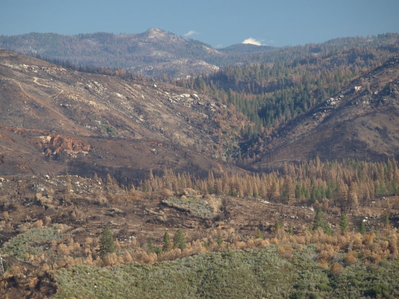
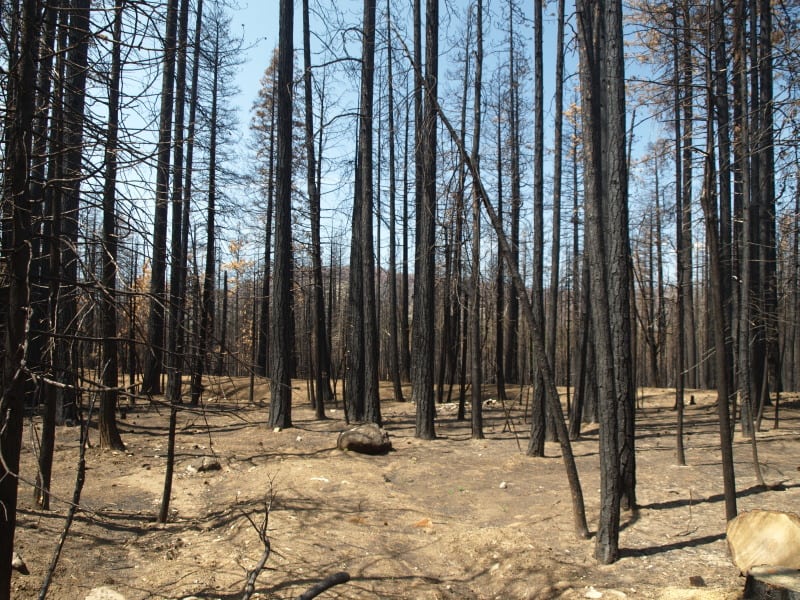
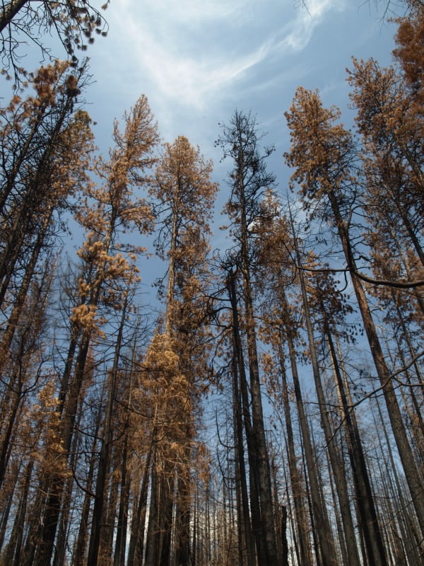
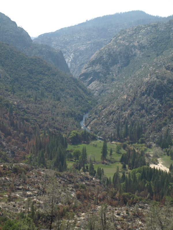
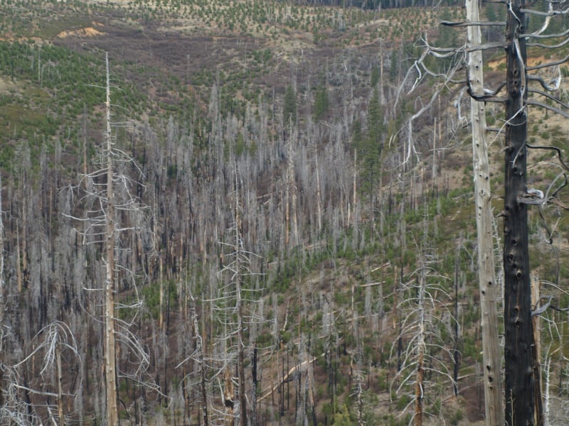
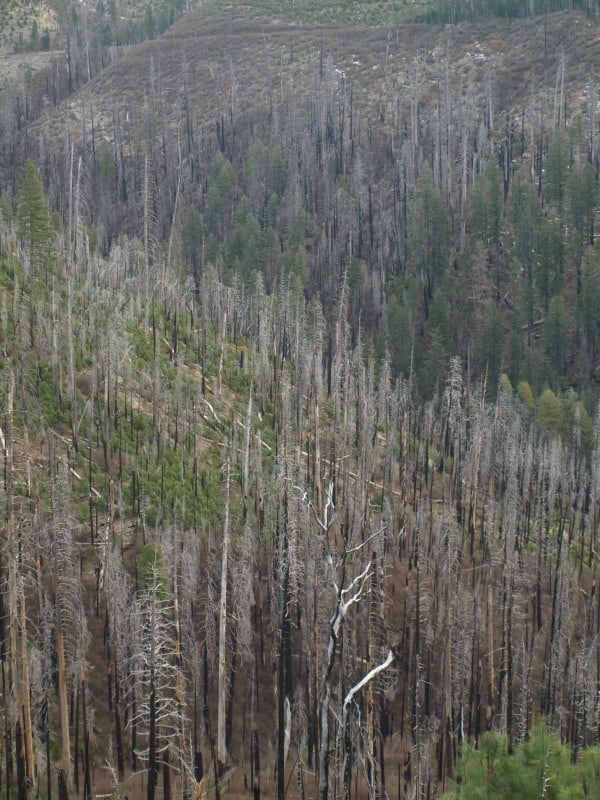
Western forests today experience fewer high-severity wildfires than they did more than a century ago, depriving some fire-dependent species and stifling biodiversity, according to a new study.

The study challenges conventional wisdom held by politicians and the Forest Service that the West is experiencing an unnatural burst in uncharacteristic wildfires as a result of a century of wildfire suppression.

In fact, some Western forests are experiencing a “deficit” in high-intensity blazes and in some cases should be encouraged to burn, said the study published this month in the journal PLOS ONE.

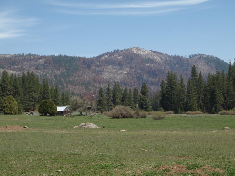
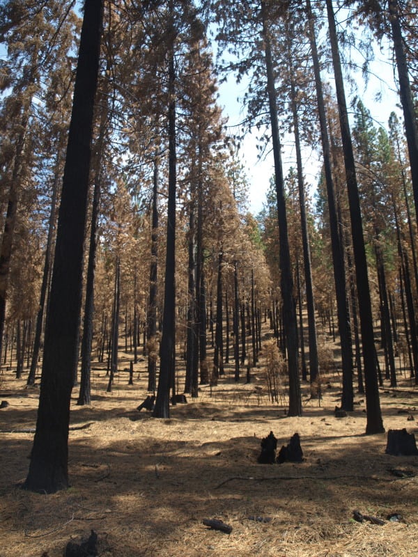
It questioned the government’s policy of mechanically thinning, or “restoring,” backcountry areas to ensure fires stay low to the ground and create “park-like” conditions. Thinning to reduce high-severity wildfire can reduce habitat for the imperiled black-backed woodpecker, often requires new roads and can introduce invasive species into the forest, the study authors said.

It’s bound to spark some controversy considering high-severity wildfires threaten lives and property and drain billions of dollars in taxpayer money each year. Moreover, aggressive forest thinning and restoration policies are politically popular because they create rural jobs and seek to mitigate wildfire threats to communities.

“Given societal aversion to wildfires, the threat to human assets from wildfires, and anticipated effects of climate change on future wildfires, many will question the wisdom of incorporating historical mixed-severity fire into management goals,” the study said. “However, a major challenge lies with the transfer of information needed to move the public and decision-makers from the current perspective that the effects of contemporary mixed-severity fire events are unnatural, harmful, inappropriate and more extensive due to fire exclusion — to embrace a different paradigm.”

The study was funded by Environment Now, a nonprofit foundation in California whose goals include “preserving and restoring coastal, freshwater and forest ecosystems.”

It was independently conducted by 11 scientists from several Western universities, the Canadian Forest Service, the Earth Island Institute and Geos Institute.

The study used U.S. Forest Service data and other published sources to explore the historical prevalence of “mixed-severity fire regimes” in ponderosa pine and mixed-conifer forests in western North America and to try to determine whether mixed-severity fire patterns in those forests had changed as a result of the past century of fire suppression.

On the latter question, it concluded that the past century of fire suppression has not “greatly increased the prevalence of severe fire,” even though fuel levels in Western forests are believed to be much higher.

Since 1930, the rate of young forest establishment fell by a factor of four in the Sierra Nevada and Southwest, by a factor of three in the Klamath, and by half in the eastern Cascades and central and northern Rockies, it said.

The study recommends the government focus its fire mitigation work adjacent to homes in the wildland-urban interface instead of in the backcountry, where managed wildland fires could promote ecological benefits.

“The need for forest ‘restoration’ designed to reduce variation in fire behavior may be much less extensive than implied by many current forest management plans or promoted by recent legislation,” the study said. “Incorporating mixed-severity fire into management goals, and adapting human communities to fire by focusing fire risk reduction activities adjacent to homes, may help maintain characteristic biodiversity, expand opportunities to manage fire for ecological benefits, reduce management costs, and protect human communities.”

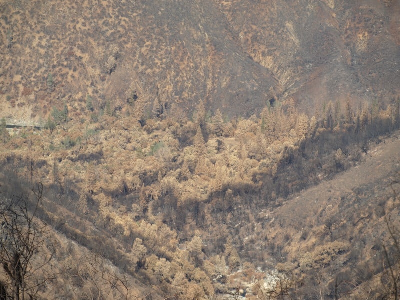
But other scientists and policymakers have argued that the societal benefits of taming mega-fires often trump whatever ecological benefits they may produce. In addition, climate change is expected to intensify droughts that create dangerously dry fuel conditions. Fire seasons are more than two months longer than in the 1970s, the Forest Service has said. (Editor’s note: using 1970s as the starting point is disingenuous–the 1950s-1980s were cooler and moister)

A study commissioned by the Interior Department and led by Northern Arizona University last spring found that although hazardous fuels treatments near communities can reduce wildfire risks to homes and people, backcountry fuels treatments are important to prevent mega-fires that can scorch watersheds and drain federal wildfire budgets (E&ENews PM, May 28, 2013).

While fire in the backcountry can be beneficial if it stays low to the ground, landscape-scale “crown” fires can damage watersheds, tarnish viewsheds and threaten communities, NAU’s Diane Vosick, one of the study authors, said last spring.

“In order to get ahead of the cost of large and severe fire, more treatments will be needed outside the wildland-urban interface,” Vosick told the Senate Energy and Natural Resources Committee last June.

The Forest Service and Interior Department also face political pressure to restore backcountry areas.

In December 2011, Congress inserted language in its appropriations report ordering both agencies to halt policies that direct most hazardous fuels funding to the wildland-urban interface, spending it instead on the “highest priority projects in the highest priority areas.”

For now, “restoration” across the National Forest System remains popular policy in Congress and in Western states.

According to the Forest Service, the states of Florida, Georgia, Utah, California, Texas, Arizona, New Mexico and Colorado have all experienced their largest or most destructive wildfire in just the last several years. Wildfires burn twice as many acres annually compared with the 1970s, and the number of wildfires annually that cover more than 10,000 acres has increased sevenfold.

Forest Service Chief Tom Tidwell last week told Congress there are nearly two dozen landscape-scale collaborative forest restoration projects underway that seek to “re-establish natural fire regimes and reduce the risk of uncharacteristic wildfire.”

“Our findings are sure to be controversial as each year federal agencies spend billions of dollars in fuel reduction costs in the backcountry based on the assumption that we have more high-severity fire now than we did historically,” said Dominick DellaSala, chief scientist at the Geos Institute, one of the study’s authors. “Fuel treatments are best targeted immediately adjacent to where people live, given that the increasing costs of suppressing fires is not ecologically justifiable and may, in fact, produce artificially manipulated landscapes that need more fire to remain healthy and productive.”

Examining Historical and Current Mixed-Severity Fire Regimes in Ponderosa Pine and Mixed-Conifer Forests of Western North America

The other day I got the following note and link to some new relevant research from Douglas Bevington, author of The Rebirth of Environmentalism: Grassroots Activism and the New Conservation Movement, 1989-2004.  Bevington’s note is shared below with his permission, along with a link to the new study and article. . – mk

——————

I wanted to let you know about an important new study that was just published by the high-profile science journal PLOS ONE. The article, titled “Examining Historical and Current Mixed-Severity Fire Regimes in Ponderosa Pine and Mixed-Conifer Forests of Western North America,” was co-authored by 11 scientists from various regions of the western US and Canada.

Their study found that there is extensive evidence from multiple data sources that big, intense forest fires were a natural part of ponderosa pine and mixed-conifer ecosystems prior to modern fire suppression. These findings refute the claims frequently made by logging and biomass advocates that modern mixed-severity forest fires (erroneously called “catastrophic” fires) are an unnatural aberration that should be prevented through more logging (“thinning”) and that more biomass facilities should be built to take the resulting material from the forest.

In contrast to these claims, logging done ostensibly to reduce fire severity now appears to be not only unnecessary, but also potentially detrimental when it is based on erroneous notions about historic forest conditions and fire regimes. These findings have big implications for biomass and forest policy, so I encourage you to take a look at this article.

The full article in PLOS ONE is available here.

Here are a few key points from the abstract and conclusion:

Abstract, p. 1

“There is widespread concern that fire exclusion has led to an unprecedented threat of uncharacteristically severe fires in ponderosa pine and mixed-conifer forests of western North America. These extensive montane forests are considered to be adapted to a low/moderate-severity fire regime that maintained stands of relatively old trees. However, there is increasing recognition from landscape-scale assessments that, prior to any significant effects of fire exclusion, fires and forest structure were more variable in these forests….We compiled landscape-scale evidence of historical fire severity patterns in the ponderosa pine and mixed-conifer forests from published literature sources and stand ages available from the Forest Inventory and Analysis program in the USA. The consensus from this evidence is that the traditional reference conditions of low-severity fire regimes are inaccurate for most forests of western North America….Our findings suggest that ecological management goals that incorporate successional diversity created by fire may support characteristic biodiversity, whereas current attempts to ‘‘restore’’ forests to open, low-severity fire conditions may not align with historical reference conditions in most ponderosa pine and mixed-conifer forests of western North America.”

Conclusion: p. 12

“Our findings suggest a need to recognize mixed-severity fire regimes as the predominant fire regime for most of the ponderosa pine and mixed-conifer forests of western North America….For management, perhaps the most profound implication of this study is that the need for forest ‘‘restoration’’ designed to reduce variation in fire behavior may be much less extensive than implied by many current forest management plans or promoted by recent legislation. Incorporating mixed-severity fire into management goals, and adapting human communities to fire by focusing fire risk reduction activities adjacent to homes, may help maintain characteristic biodiversity, expand opportunities to manage fire for ecological benefits, reduce management costs, and protect human communities.”

“Counties in Crisis”: A Draft Introductory Narrative

Note from Ron:  Earlier this month, I posted an article on Shoshone County, Idaho’s 2005 documentary, “Forests in Crisis” at the “Not Without a Fight!” blog — including a field for viewing the 27-minute film.  Yesterday, by way of continuing the same theme, I posted a possible draft intro to a new and updated version of the County’s film, now titled, “Counties in Crisis.”  Sharon generously invited me to cross-post the newer article to “A New Century of Forest Planning.”  Thank you, Sharon!

U.S. national forests and grasslands

Scene One:  Setting Up The Problem

It’s a story that, for the most part, has fallen below the national news horizon.

America’s 155 national forests cover almost 190 million acres, the great majority in the West.  This great expanse of forested land falls across and affects more than 700 American counties, roughly a fifth of the nation’s total number of counties.  Some counties host only small patches of national forest while in others national forests may cover much or even most of their landscapes.

This presence has manifold consequences for local communities.  The Forest Service owns and governs these lands, thus limiting the inputs of local citizens and governments to an advisory role only.  For many years, national forests and local communities got on tolerably well.  The Forest Service’s multi-use philosophy made ample room for the needs and economies of local communities.  But this working relationship has broken down.  Now, local communities and counties have in effect become unhappy captives of Forest Service policies and limitations –- policies that no longer serve local needs and aspirations.

There are four basic local needs that define the relationship, and thus also the breakdown:

  1. The protection and enhancement of forest health;
  2. the protection and enhancement of local forest-related economic activity;
  3. the planning and execution of hazardous fuels reduction and forest thinning to reduce threat of catastrophic wildfire; and
  4. the provision of adequate support for the functioning or operation of local governments and schools.

In better times, each of these four domains helped serve the requirements of the others, all acting in concert to keep local communities and their surrounding forests healthy, productive, and in balance.  In bad times, however, the four domains act against one another, thus exacerbating the circumstances within each domain.  Without timber harvests, for example, the increase of fuel in the forest worsens the risk of catastrophic wildfire; by the same token, the absence of revenue from such harvests weakens county government and school resources and, as well, shortchanges Forest Service efforts to manage forest health.   (continue reading)

FS’s Rocky Mtn Research Station: Rural homes must be more fire resistant

Sometimes you wake up in the morning and the newspaper has an article that basically re-states what you’ve been saying for nearly the past twenty years, at least as far as home wildfire protection is concerned.

Making rural homes more resistant to fire is the best way to reduce the number of homes lost to wildland fires, according to a recent paper published by Missoula researchers.

That statement may suggest a “duh, right,” but in the past much of the pressure to reduce the intensity and occurrence of wildland fires has been on federal and state land managers to remove fuels from public lands through logging.

“We have the ability to change the character of the fires that come out of the wildlands,” said David Calkin, of the Forest Service’s Rocky Mountain Research Station in Missoula, the principal author of the research. “But if we’re concerned about homes burning up, then we need to think about the home ignition zone.”

Jack Cohen, Mark Finney and Matthew Thompson collaborated on the research paper.

The home ignition zone is the home itself and the area immediately around it. If a homeowner’s land is left untreated to prevent fire ignition, even low-intensity fires from far away have produced firebrands carried by the wind for miles that have burned houses, Calkin’s research showed.

Read Brett French’s entire article here.