Field Trip to Buffalo Gap National Grassland, Wall, South Dakota: One of the Forest Service’s Little-Known Treasures

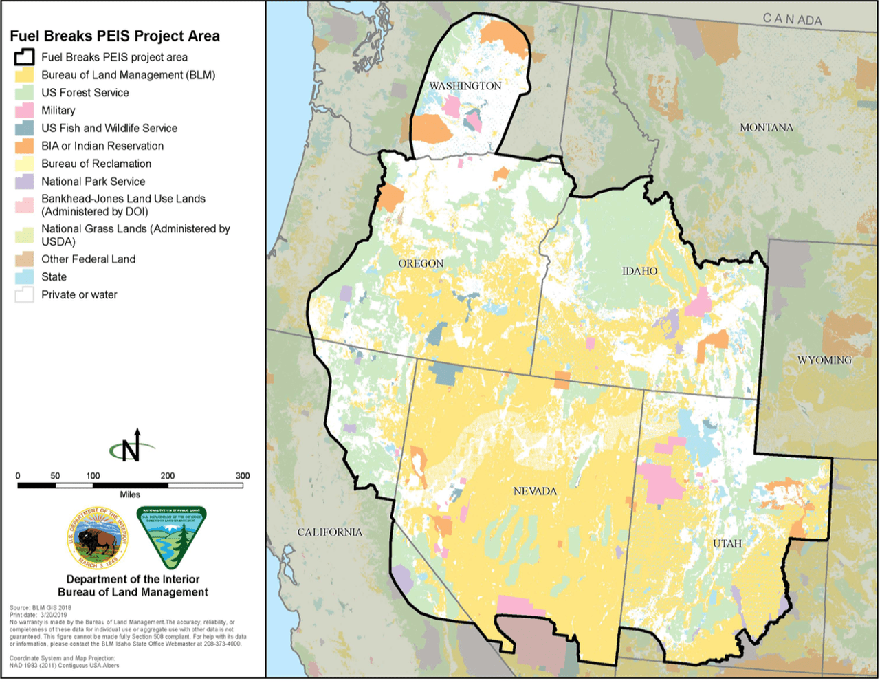
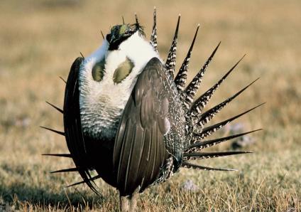
A recent Rocky Mountaineers (Forest Service retiree organization) annual gathering included a field trip to the Buffalo Gap National Grassland.  Wall, South Dakota is also the home of the National Grasslands Visitor Center that tells the story of the National Grasslands.. an important part of our country’s natural heritage.  For those of you who like field trips, you can get some of the fun without the travel. Travis Mason-Bushman (with the hat) and all those young people we met are outstanding at telling their stories and answering questions.   They are dedicated, committed, professional with a depth of knowledge and experience.   I know I can shuffle off this mortal coil and these folk will take care of the National Grasslands and Forests just fine.

One of the videos has some breathing at the beginning, which is distracting, but it goes away.

The story of the black-footed ferret recovery is very interesting, including how they are being managed to protect from disease, and their genetics.  The black-footed ferrets that are alive today in the United States come from a foundation of seven ferrets.There’s even a discussion in the video of using high-tech techiques.. cloning.. to increase genetic diversity.  Tissue samples of Willa, a captured ferret from Meeteetse, were cryopreserved when she passed away. They were thawed and used to produce a cloned ferret who was an exact clone of Willa. Unfortunately she (Elizabeth Ann) required surgery and cannot be bred.  If you’re interested, this from the Meeteetse Museums has all the juicy and technical details.   The mechanisms that organisms have to continue to live, thrive and survive small population sizes are not really understood.  Estimates of MVP are based on many assumptions of things we don’t know and don’t understand.  It’s a mysterious human process by which “best guess at this time” is transmuted into “scientists tell us” and then directly into policy.

This is the story of some dispersed recreation challenges the District has.  This area is adjacent to the Badlands National Park, which has limited camping, and camping has mushroomed.  While the District has little recreation funding or staff; they are doing what they can.


Travis does a great job, as always, explaining the history of the Grasslands.  I don’t see it exactly the same way, though.   Travis says something like “people determined that the land was best left alone” which I don’t think is how people thought in the 1930s.   They wanted to get vegetation back.. hence reseeding and shelterbelts, so that the land could be used for grazing.  The idea was also to show neighboring farmers better practices.

Here’s an example from a Pawnee National Grassland history:

The area along Crow Creek near Briggsdale was the first reclamation and demonstration plot in this area. Seventy acres of meadow improvement began with the construction of two dams and three diversion ditches to spread the flood water over the meadows and provide limited irrigation on other areas. Throughout the other acquired areas, existing fences were torn down, moved or new fences constructed to surround an economically manageable pasture. Springs were developed and wells dug. Windmills were erected and “catch basins” constructed to collect as much run-off water as possible. The policy was “no cow would have to go more than three-quarters of a mile for water.” The plowed and denuded lands were planted to mostly crested wheatgrass, an introduced species from Russia which is well adapted to our climate and is palatable to livestock. Trees were planted to form wind breaks and provide habitat for wildlife. Within two years, the planted grasses revegetated the plowed areas and grazing was allowed on a limited basis.

And

This was not accomplished without trials, anger and frustration. Attempts were made to have the land returned to private ownership, but were defeated. The deep-seated individualism of the westerner made it difficult for them to accept a change from the old ways. Successful demonstrations and evident restoration of the land occurred and gradually the new, proven methods of land management were accepted by most of the population, both association members and nonmembers.

One of the reasons I bring this up is that it reminds me of watershed restoration which seems agreed upon and in some senses easier than some of the ideas we have now about “ecological restoration” which requires, in some cases, attempting to bring back all the plants and animals that previously lived there (at the correct densities and age structures, but of course not the same genetics). “We don’t want dirt to blow away and we want vegetation to cover the soil, hopefully something edible for cows” is a water and soil based restoration.. and fast forwarding, if we were to focus on these basics (soil, water, and air) and let the plants and animals fall where they may, the work of restoration would be simpler. Then hydrologists and soil scientists would be in charge instead of economists, endangered species biologists, historic vegetation ecologists, or climate modellers. It would be an interesting thought experiment, anyway.

In researching this post, I ran across an interesting website called the Encyclopedia of the Great Plains. Many interesting topics to browse there, and here’s the entry for climate.

The Great Plains, therefore, has a large range in both annual and daily temperatures. During the midwinter months (January and February), when cold, dry air from central Canada dominates, temperatures are very cold, with mean temperatures varying from 40ºF across the Southern Plains to as low as 10ºF across the Canadian Prairies. During midsummer (July and August), when the Plains are dominated by either warm, moist air from the Gulf of Mexico or warm, dry air from the Southwest, mean temperatures increase to approximately 80ºF through the Southern Plains and approximately 66ºF across the Canadian Prairies. This gives the region a much larger range in annual temperature than is found elsewhere in North America. For example, the range in mean monthly temperature between January and July in Omaha, Nebraska, is approximately 56ºF, while in Philadelphia, Pennsylvania, and San Francisco, California (each at a similar latitude), the ranges are 46ºF and 14ºF respectively.

***

The year-to-year variability in temperature and precipitation across the Great Plains is very large. This variability is especially evident in the recurrent problem of drought. The very warm and often dry summer weather that is characteristic of the Plains leads to high evaporation and transpiration (water loss from plants) rates. Soils are often depleted of their moisture, leading to stressed natural and cultivated vegetation. A measure of the lack of available soil moisture for plants, the soil moisture deficit, has been calculated for the entire Great Plains region for the period 1895 through 1994. From this it is clear that the Plains as a whole has undergone recurrent periods of drought over the last century, especially during the 1930s (the Dust Bowl years) and the 1950s. The large annual (within one year) and interannual (year-to-year) variability of Great Plains climate makes the region a natural laboratory for studying the effects of climate variability on a host of problems associated with the interaction of humans with their environment.

Perhaps the people, animals and plants of the Great Plains have something to teach us about adapting to any changes in climate and climate variability.

Science is clear: Catastrophic wildfire requires forest management

Science is clear: Catastrophic wildfire requires forest management” was written by Steve Ellis, Chair of the National Association of Forest Service Retirees (NAFSR), who is a former U.S. Forest Service Forest Supervisor and retired Bureau of Land Management Deputy Director for Operations—the senior career position in that agency’s Washington, D.C., headquarters.

I have extracted a few snippets (Emphasis added) from the above article published by the NAFSR:

1) Last year was a historically destructive wildfire season. While we haven’t yet seen the end of 2021, nationally 64 large fires have burned over 3 million acres. The economic damage caused by wildfire in 2020 is estimated at $150 billion. The loss of communities, loss of life, impacts on health, and untold environmental damage to our watersheds—not to mention the pumping of climate-changing carbon into the atmosphere—are devastating. This continuing disaster needs to be addressed like the catastrophe it is.

2) We are the National Association of Forest Service Retirees (NAFSR), an organization of dedicated natural resource professionals—field practitioners, firefighters, and scientists—with thousands of years of on the ground experience. Our membership lives in every state of the nation. We are dedicated to sustaining healthy National Forests and National Grasslands, the lands managed by the U.S. Forest Service, to provide clean water, quality outdoor recreation, wildlife and fish habitat, and carbon sequestration, and to be more resilient to catastrophic wildfire as our climate changes.

3) As some of us here on the Smokey Wire have been explaining for years, the NAFSR very clearly and succinctly states:
Small treatment areas, scattered “random acts of restoration” across the landscape, are not large enough to make a meaningful difference. Decades of field observations and peer reviewed research both document the effectiveness of strategic landscape fuel treatments and support the pressing need to do more. The cost of necessary treatments is a fraction of the wildfire damage such treatments can prevent. Today’s wildfires in overstocked forests burn so hot and on such vast acreages that reforestation becomes difficult or next to impossible in some areas. Soil damage and erosion become extreme. Watersheds which supply vital domestic, industrial, and agricultural water are damaged or destroyed.

4) This summer, America watched with great apprehension as the Caldor Fire approached South Lake Tahoe. In a community briefing, wildfire incident commander Rocky Oplinger described how active management of forestlands assisted firefighters. “When the fire spotted above Meyers, it reached a fuels treatment that helped reduce flame lengths from 150 feet to 15 feet, enabling firefighters to mount a direct attack and protect homes,” The Los Angeles Times quoted him.

5) And in a Sacramento Bee interview in which fire researcher Scott Stephens was asked how much consensus there is among fire scientists that fuels treatments do help, he answered “I’d say at least 99%. I’ll be honest with you, it’s that strong; it’s that strong. There’s at least 99% certainty that treated areas do moderate fire behavior. You will always have the ignition potential, but the fires will be much easier to manage.” I (Steve Ellis) don’t know if it’s 99% or not, but a wildfire commander with decades of experience recently told me this figure would be at least 90%. What is important here is that there is broad agreement among professionals that properly treated landscapes do moderate fire behavior.

6) During my career (Steve Ellis), I have personally witnessed fire dropping from tree crowns to the ground when it hit a thinned forest. So have many NAFSR members. This is an issue where scientist and practitioners agree. More strategic landscape treatments are necessary to help avoid increasingly disastrous wildfires. So, the next time you read or hear someone say that thinning and prescribed fire in the forest does not work, remember that nothing can be further from the truth.

BLM Great Basin fuel break EIS

The BLM has released its final decision to implement 11,000 miles of fuel breaks in six states.  The figure is in miles because the fuel breaks would be constructed along roads and right-of-ways.  Given our discussion of the Forest Service trend towards large landscape “condition based” management decisions, this language from an article quoting the BLM piqued my curiosity (my emphasis added):

According to Jennifer Jones, a spokeswoman for the BLM, the program will help streamline the implementation process by reducing or eliminating the need for environmental analysis. Once the plan is finalized and funding available, said Jones, “offices will be able to use it immediately and for many years to come.”

The timeline for implementation and the location of fuel breaks will depend on what offices develop plans and apply for funding.

The BLM’s notice of availability added:

… these potential treatment areas cover approximately 38 million acres within the project area boundary.

The goal of these Programmatic EISs is to significantly minimize the subsequent National Environmental Policy Act (NEPA) work required to approve on-the-ground projects.

(A second EIS will address “fuel reduction and restoration” over the same area.)

These statements sound like the more conventional approach to programmatic NEPA analysis (such as has been done for the use of herbicides).  They are intended to provide context for subsequent site-specific analysis that will produce overall savings in planning efficiency.  They make no pretense that this large scale analysis would necessarily be a substitute for site-specific analysis as some Forest Service proposals have stated. This kind of “merely programmatic” analysis has sometimes been given more leeway by the courts because a subsequent site-specific analysis would follow that would address site-specific issues and effects that have not been addressed.

The BLM decided also to do an EIS, unlike some of the Forest Service efforts that used an EA.  This analysis of effects of fuel breaks is also probably more site-specific than area-wide, “condition-based” Forest Service proposals because they know where the candidate corridors are, and they know the area of BLM lands where no action would be taken (away from these corridors).   (The scientific validity of fuel breaks is also discussed.)

Recovery planning for the Gunnison sage-grouse

The U. S. Fish and Wildlife Service has released a draft recovery plan for the Gunnison sage-grouse in Colorado and Utah.  The Center for Biodiversity doesn’t like it, but more to the point, they like less how the BLM is managing Gunnison sage-grouse.  More to the point because recovery plans are not mandatory, while federal land management plans can be – and plan components must be mandatory to be considered “regulatory” enough to carry much weight in ESA listing and delisting decisions.  As the FWS said, “Establishing durable regulatory mechanisms that are binding and enforceable, such as revised land use planning amendments, will be important for recovery.”

CBD:

The recovery plan comes on the heels of BLM decisions not to designate any Areas of Critical Environmental Concern for Gunnison sage-grouse in the Tres Rios and Uncompahgre Resource management plans, and to adopt inadequate safeguards for the birds’ habitat in recent land-use plans. For example, although the draft recovery plan calls on federal land-management agencies to improve their resource management plans and protect suitable habitat within four miles of breeding sites, the BLM’s August 2019 proposed resource plan for its Uncompahgre Field Office protects only habitats within 0.6 miles of breeding sites. The BLM admits this would “fall short of minimum protection standards to maintain sage-grouse viability.”

“Bringing the Gunnison sage-grouse back from the brink requires decisive and concerted action, but instead we have two federal agencies working against each other,” said Michael Saul, a senior attorney at the Center for Biological Diversity. “The Fish and Wildlife Service is urging federal land managers to improve protections for public-land habitat, but the BLM is moving in the opposite direction. This is a recipe for extinction for this beautiful bird. We’ll do everything possible to keep that from happening.”

The timing is also such that BLM plans were released prior to the draft recovery plan.  That means that the BLM should start taking another look at how their plans address this species and take into account the new information and recommended measures.  The same is true for the 10% of sage-grouse habitat that occurs on national forest lands. BLM is not subject to NFMA, so its obligation to maintain species viability to avoid listing under ESA is not as clear as for the Forest Service.  Forest Service plans must “contribute to recovery” of listed species, so failure to address elements of this recovery plan when it is final should raise serious questions.

In addition to specific conservation measures like the four-mile buffers for breeding leks, the draft recovery plan provides some specific desired conditions that could be included in land management plans:

2. Regulatory mechanisms or other conservation plans or programs, such as land-use management plans, reduce and ameliorate threats associated with habitat loss and degradation in all populations, such that:

A. Habitat in Dove Creek is improved and maintained at a quantity calculated to support a HMC of 30, although this criterion is not measured by achieving the target HMC.

B. Habitat in CSCSM is maintained at a quantity calculated to support a HMC of 7, although this criterion is not measured by achieving the target HMC.

C. Habitat is improved and maintained in Gunnison Basin, San Miguel, Piñon Mesa, Crawford, and Monticello at a quantity calculated to support the target HMCs as listed in Table 1.

At a minimum, the land management agencies will need to explain how these plans contribute to meeting their requirements under ESA to manage their programs to promote recovery of listed species, which should include how they are implementing the final recovery plan.

Trump Administration sage-grouse plans stopped

The district court for Idaho has enjoined the Trump Administration’s attempt to cut back protection of sage-grouse on BLM lands in Idaho, Wyoming, Colorado, Utah, Nevada/Northeastern California, and Oregon from that provided by plan amendments in 2015. (A similar decision has been pending for national forest plans.) The changes made in the 2019 amendments to BLM land management plans can not be implemented, and the provisions in the 2015 amendments will apply (projects must be consistent with the 2015 amendments) until the case is decided on the merits.  (A link to the opinion is included with this news release.)

Moreover, the court telegraphed the merits pretty clearly:

“… the plaintiffs will likely succeed in showing that (1) the 2019 Plan Amendments contained substantial reductions in protections for the sage grouse (compared to the 2015 Plans) without justification; (2) The EISs failed to comply with NEPA’s requirement that reasonable alternatives be considered; (3) The EISs failed to contain a sufficient cumulative impacts analysis as required by NEPA; (4) The EISs failed to take the required “hard look” at the environmental consequences of the 2019 Plan Amendments; and (5) Supplemental Draft EISs should have been issued as required by NEPA when the BLM decided to eliminate mandatory compensatory mitigation.”

(1) “The stated purpose of the 2019 Plan Amendments was to enhance cooperation between the BLM and the States by modifying the BLM’s protections for sage grouse to better align with plans developed by the States. While this is a purpose well-within the agency’s discretion, the effect on the ground was to substantially reduce protections for sage grouse without any explanation that the reductions were justified by, say, changes in habitat, improvement in population numbers, or revisions to the best science contained in the NTT and CTO Reports.” The agencies did not fulfill their duty to explain why they are now making a different decision based on the same facts.

(2) The no-action alternative did not meet the purpose and need, and there was only one action alternative. “Common sense and this record demonstrate that mid-range alternatives were available that would contain more protections for sage grouse than this single proposal.”

(3) The BLM prepared six EISs based on state boundaries, but failed to provide the “robust” cumulative effects analysis this situation required. In particular, “connectivity of habitat – requires a large-scale analysis that transcends the boundaries of any single State.”

(4) “Certainly, the BLM is entitled to align its actions with the State plans, but when the BLM substantially reduces protections for sage grouse contrary to the best science and the concerns of other agencies, there must be some analysis and justification – a hard look – in the NEPA documents.” The court took particular note of the EPA comments that were ignored, and Fish and Wildlife Service endorsement of the 2015 amendments in deciding not to list the species under ESA because they adopted scientific recommendations (see below).

(5) Compensatory mitigation measures were eliminated after the draft EIS, which “appears to constitute both “substantial changes” to its proposed action and “significant new circumstances” requiring a supplemental EIS.

The case provides a good example of how science is considered by a court, which allowed declarations from outside experts to determine if relevant environmental consequences were ignored. The court relied heavily on earlier scientific reports that included normative “recommendations,” but the court focused on their scientific conclusions, such as “surface-disturbing energy or mineral development within priority sage-grouse habitats is not consistent with the goal to maintain or increase populations or distribution,” and “protecting even 75 to >80% of nesting hens would require a 4-mile radius buffer.” The Final EISs stated that there would be no measurable effects or they would be beneficial to sage-grouse, but the BLM either had no analysis or ignored this contrary information.


Grasslands More Resilient Carbon Sinks Than Forests?: Behind the Study

Study Figure 1: Grassland (A) and forest (B) retreat or expansion in response to 21st century climate changes. Blue indicates expansion; red indicates contraction. Forests retreat in all future climates except those associated with aggressive emissions reductions (RCP 2.6)/Sharon’s note: see places where trees are increasing, many under 2.6 and even some under 8.5

You all may have seen the news report “Grasslands More Reliable Carbon Sink Than Trees” I’m not exactly sure whether this site is a source of UC Davis press releases, or a more broad climate communications site.

Their basic argument is that because forests have most of their carbon above ground, and they burn up that carbon in wildfires (the video has a very nice graphic that depicts this), then grasslands are better because their carbon doesn’t burn up. First, note that this statement claims that this scientific information is relevant to policy in terms of California’s cap and trade program.

A study from the University of California, Davis, found that grasslands and rangelands are more resilient carbon sinks than forests in 21st century California. As such, the study indicates they should be given opportunities in the state’s cap-and-and trade market, which is designed to reduce California’s greenhouse gas emissions to 40 percent below 1990 levels by 2030.

So we are talking investments conceivably in the next 10 years to reduce GHGs. But what was most peculiar to me was how they went about figuring this out, and some of their results. First of all, they referred to RCP 8.5 as a “business as usual” scenario. If this were a NEPA document, we might say that there is scientific controversy around that claim. Many would say that it’s a “useful worst case scenario” not “business as usual”. Of course, you don’t have to have a Ph.D. in atmospheric physics to think that people might disagree about what’s likely to happen in the future, and that prophecy is unlikely to have a meaningful probability distribution.

Most interesting to me, though, were their efforts to predict where trees would go away and be replaced by grasslands under that climate scenario. This can be seen in the figure above, and also a figure I couldn’t copy that is a placeholder for the video for the paper here.

Tree or grass people might wonder, how could you possibly predict that, given what we know of trees and grasses? Well, it’s possible to link a variety of models. I think the authors did real nice work in explaining their paper, using an open source journal and describing the limitations of their work.

Here’s the first sentence of their results and conclusions:

In contrast to the conventional paradigm, we show that the inherent resilience of grassland vegetation to drought and wildfire (figure 1) translates to a more reliable C sink than forest ecosystems (figure 2) in response to 21st century climate changes.

But their caveats include:

Factors such as species traits, biodiversity, rapid evolution, and human management intervention could alter our model-based findings from the projections provided here. Consequently, our results indicate the potential direction of change as opposed to predictions that consider the full ensemble of ecological, physiological and management factors that can alter pathways and responses of ecosystems to climate change.

(my bold, human management intervention like fire suppression?) In what sense is it realistic to model the carbon impacts of future wildfires while not considering fire suppression?

and

Future work could focus on such factors as the evolutionary history of trees to fire, the physiological adaptations of ecosystems as well as regional species to fire, drought and climate change, the effects of biodiversity on ecosystem resilience as well as a comprehensive analysis of the goods and services provided by forests and grasslands.

The research was funded by the National Science Foundation. I wonder if on their research panels, there is ever a thought of “is there a point at which running models has little real world data that the information produced is not worth funding, or we should be clear that it is basic science with no real-world relevance? NSF doesn’t have to care whether its research is policy relevant, because its mission in broader than that, it’s mission is to “advance the progress of science” but as I’ve argued before, if researchers make the claim that it is, perhaps there should be some kind of standard. For those of you who haven’t seen my effort in this direction here’s a link to Eight Steps to Vet Scientific Information for Policy Fitness.

On wonders whether if the California policy makers had (1) framed the questions they felt they needed answered relevant to their cap n trade program (2) reviewed existing literature on grasslands, forests, trees, drought, fires and climate change, would they have prioritized this kind of study?

Greater sage-grouse amendment amendment

Three years ago the Forest Service had this to say about the greater sage-grouse:

Two US Forest Service Records of Decision and associated land management plan amendments are the culmination of an unprecedented planning effort in cooperation with the Bureau of Land Management to conserve greater sage-grouse and its habitat on National Forest System lands and Bureau of Land Management-administered lands.

Last week it was this (and they initiated a public comment period):

Since approving the plan amendments in 2015, the Forest Service has gathered information and determined that the conservation benefits of Forest Service plans in Nevada and other states can be improved. That is, through repeated scoping, close collaboration with state and other federal agencies, and internal review, the Forest Service has identified proposed changes in the text of the greater sage-grouse plan amendments which would improve their clarity and efficiency and better align them with the Bureau of Land Management and state plans.

Specifically, the Preferred Alternative makes modifications to land management plans within the issue areas of: Habitat management area designation, including designating sagebrush focal areas as Priority Habitat Management Areas compensatory mitigation and net conservation gain; minerals plan components and waivers; exceptions and modifications; desired conditions; livestock grazing guidelines; adaptive management; treatment of invasive species; and changes to clarify text and eliminate errors and redundancies.

Oddly, it sounds like all of the new information must say that sage-grouse are doing better than we thought three years ago and/or they are less vulnerable to oil and gas drilling than we thought three years ago. The most important change in forest plans is probably this one (from an AP article):

The Obama administration created three protection levels for sage grouse. Most protective were Sagebrush Focal Areas, followed by Primary Habitat Management Areas and then General Habitat Management Areas. The Forest Service plan reclassifies the 1,400 square miles (3,600 kilometers) of Sagebrush Focal Areas as primary habitat.

The focal areas allowed no exceptions for surface development, while primary habitat allowed for limited exceptions with the agreed consent of various federal and state agencies. Under the new plan, the cooperation of states and some federal agencies to exceptions in primary habitat will no longer be needed for some activities but can be made unilaterally by an “authorized officer,” likely an Interior Department worker. That appears to be an avenue for opening focal areas to natural gas and oil drilling.

This amendment decision will be subject to the 2012 Planning Rule requirements for species viability and species of conservation concern (SCC) (from the DEIS):

… the FS is considering the effect on the greater sage-grouse as a potential SCC for each LMP that would be amended by this decision. The analysis in this DEIS shows that the amendments maintain ecological conditions necessary for a viable population of greater sage-grouse in the plan area for each LMP to which the amendments would apply.

Recall that the current conservation strategy was “generally viewed as keeping the bird from being listed for federal protections under the Endangered Species Act.”  What will the Zinke that is charge of the Fish and Wildlife Service have to say to the Zinke that is in charge of the BLM (and apparently the Forest Service)? Why does this remind me of political appointee Julie McDonald’s interference with decisions about lynx? Is it more about a new boss than about new science?  “A federal lawsuit is likely.”

Some more background is provided here.

Why we need coordinated planning for habitat connectivity

The Bridger-Teton National Forest amended its forest plan in 2008 to designate the portion of the “Path of the Pronghorn” migration corridor in Wyoming for special management to protect this historic 90-mile route with a northern terminus in Grand Teton National Park used for summer range.  It’s probably the most significant action taken by the Forest Service to plan for wildlife connectivity.

The BLM chose to not play along at the southern end where major oil and gas fields are found in the species’ winter range, and the migration route lacks recognition, and protection, through BLM lands along its southern reaches.  Now they have issued an EIS for oil and gas development there.  Ideally, the EIS will disclose the effects on pronghorn migration and on the national park (using the best available science), which could include exterminating this migration and its pronghorn herd.  But I wanted to comment on the planning aspect of this problem.  BLM blames the State of Wyoming:

“It would help us out if the [Wyoming] Game and Fish were to formally designate something in there,” said Caleb Hiner, who manages the BLM’s Pinedale Field Office.

The Forest Service didn’t wait for state action to protect national forest lands.  As an environmental activist said, “The BLM has all the authority it needs to protect what it wants to protect in a site-specific document,… The BLM could decide tomorrow that it doesn’t want to lease or develop any of the NPL.”

The 220-square-mile project has major economic potential, and could generate 950 jobs and produce somewhere in the range of 3 trillion cubic feet to 5 trillion cubic feet of natural gas, Hiner said. It would add up to 350 wells to the landscape annually for the next 10 years, a level of development that equals the number of wells permitted for drilling in the BLM’s entire Pinedale Field Office during 2017.

The argument by the proponent seems to be that they can figure out mitigation well-by-well, but at that point there is little opportunity to develop an effective strategy for pronghorn to navigate the system of wells, especially with no plan-level requirement to do so.

It is important for federal land managers be leaders in coordinating connectivity conservation planning, if for no other reason that that may be what is necessary to provide for viable populations of migrating species to continue to use federal lands.  The absence of a plan based on an overarching strategy for the full extent of the herd’s range could now be fatal to a ecological phenomenon that has been occurring, in part on national forest lands, for thousands of years.


Forest Service prosecutes mudders

The federal government does go to court sometimes to protect our natural resources, here in North Dakota:

Three men accused of damaging U.S. Forest Service land four years ago while going mudding in the Little Missouri National Grasslands now face criminal charges in federal court.

Five full-sized pickups got stuck in the mud in the area known as Estes Springs. The individuals involved then got two road graders to try to recover the pickups, but then got the road graders stuck in the wet and muddy conditions.

The area has signs indicating it is National Forest Service land and directing the public to stay on established roads and trails.

Jan Swenson, executive director of the Badlands Conservation Alliance, saw photos of the incident four years ago and said it looked like the pickups had driven donuts in the mud following a rainstorm.

“It is great to see the Forest Service following through,” Swenson said. “It would be encouraging to see other government entities follow through on enforcement issues as well.”

Forest Service on the bandwagon to unprotect sage grouse

Time is running out to comment on the notice that initiated “the scoping process to solicit public comments on greater sage-grouse land management issues that could warrant land management plan amendments” on 15 national forests and grasslands.  (Comments are due Friday.)  The majority of sage grouse habitat is found on BLM lands (I think the Forest Service has 8%) and the Forest Service is following behind the Department of Interior’s lead to “consider” rolling back restrictions, especially those that interfere with oil and gas drilling.  Those restrictions were added to Forest Service and BLM plans in amendments that were adopted in 2015 pursuant to the 1982 planning regulations for species viability, and have been credited with avoiding the need to list sage grouse as threatened or endangered.  The Forest Service concedes that amendments it would propose would be likely to be “directly related” to, and therefore subject to, the new diversity and viability requirements of the 2012 Planning Rule.  More background from the Forest Service here.