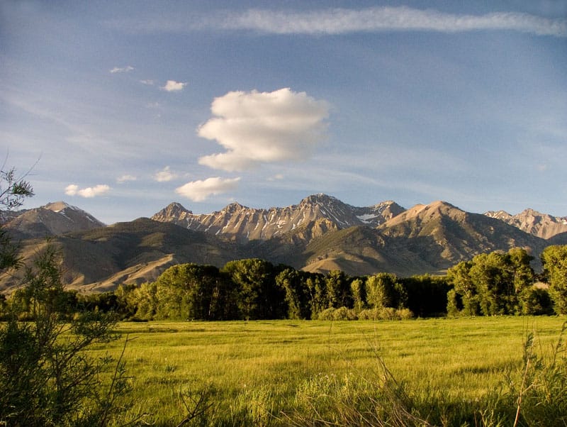
This will be the first of many postings to share my photography associated with our National Forests. I have worked on 23 National Forests across the country, in 11 states. The photos I took while working for the Feds will be available for free limited usage, if someone thinks it might help their cause. Others can be available matted and/or framed *smirks*
(Edit: Sharon wanted bigger!)
Several of these peaks in the Lost River Range of Idaho are over 12,000 feet. I met this other detailer, who was doing wildlife surveys, and was shocked to learn that he was climbing part of the way up these mountains, looking for rare species. Yes, he was over 50 years old! I was doing aspen surveys, mapping, photographing and analysis, in support of a new grazing plan. It was in my power to recommend protective measures for the impacted aspen stands. Of course, everything that eats grass, eats aspen. I felt it was meaningful work.

Excellent Larry.
Well seen. Well felt.
Your sense of light, your appreciation for richness of depth and color does your subject justice. It is very clear this comes from the heart.
Your narrative is a nice addition too — I can almost see a lone climber descending in the distance.
Larry, 50 is the new 40 ;)? Anyway, I met a 65 year old climbing a 14er last year and yes, he was going faster than I was . Of course, pretty much everyone goes faster than I do. Aging just makes conditioning more important. My opinion, gained from many painful experiences.
Larry Harrel takes some of the finest photographs of America’s forests as anyone. I hope steps are being taken to archive his work as it grows and continues to be refined. The correlation of photograph locations over time can produce incredible repeat photography sequences that can be analyzed for documented change, and the dynamics involved in those changes. Both Charles Kay and Jack Ward Thomas have published important repeat photography works, as have Fred Hall and several other scientists. Larry’s work deserves this type of consideration, particularly if it can be incorporated into pre- and post- wildfire, bug-kill, and restoration project planning and documentation.
Plus, many of the prints are truly beautiful or inspiring on their own.
Here is a link to the Google Maps satellite view.
http://maps.google.com/maps?hl=en&ll=44.010102,-113.762741&spn=0.401004,1.056747&t=h&z=11
I am finding these satellite pictures to be fun to explore, and visit the places you worked in years ago.
Larry : Size matters;)! It is beautiful
Bob: Great idea! I would think that that would be a simple thing to do given today’s applications.. a database of photos linked by gps coordinates and date. does anyone know of someone doing this?
Hi Sharon:
We’ve been trying to do this very thing for several years, but keep getting waylaid by software conflicts, available resources, and my own limitations. We are currently working on a set of 2300+ GPS-referenced photos taken of the Coos, Coquille, Elk, and Sixes basins last year (about 1,400,000 acres) with a Garmin 550T, and about 5,000 GPS-referenced photos taken of the Upper South Umpqua in 2010, in which we kept the GPS references in an Excel database ledger. We also keep trying to integrate QTVR panoramas, but keep creating conflicts. I think we’re ready to try Google Earth now, once some more time becomes available.
Here’s a couple of past attempts:
http://www.orww.org/B&B_Complex/Repeat_Photography_Grid/index.html
http://www.orww.org/Rivers/Umpqua/South/Upper_Headwaters_Project/Photographs/index.html
Once funds become available, both of these sites need to be revisited and made functional — but the basic idea and datasets are in place.
Bob Z.
This is a beautiful photo! Have you considered sharing these with the National Forest Foundation? I know they would be very interested in these! They are always looking for ways to “show off” all the beautiful places that our National Forests offer.
Some I can offer up for free, and some I would ask for a usage fee, if they do such a thing. I had a Government digital camera, which I used at work. Legally, those shot “on the clock” are, at least, partly-owned by the Forest Service, and cannot be offered for sale. Future picture postings will indicate picture status.
Yes, Mike, that “golden hour” light was really in effect. I need to review that evening’s pictures and see if I can dredge up some others gathering “digital dust”. It’s always cool to find a gem that you’ve overlooked for weeks, months or years.
Larry, you might check out the following website to “post” your photos. It’s made up of individual photographers who post JPEG’s, some are free “public domain”, and some are Fee (copyright). I love the site. It’s a good site for “stock photos” of forestry, logging and wildfire. It was started by a bright young lady named Kari Greer,whose “wildfire” photos you would certainly recognise. It’s called “forestphoto”
Here’s the link:
http://www.forestphoto.com/asset-bank/action/viewHome