 If there were a The Smokey Wire Fix Not Fight Timely Innovation Award, this effort by the Colorado Mountain Club would be a winner. We’ve been talking about keeping track of recreation impacts and here is a way for volunteers to provide information, and also for volunteers to help fix the problems. I’m sure others have been frustrated by wanting to report something on a trail and not having the time to figure out which District you’re on, or want to call around to find the Recreation staff. And if it’s that hard for retirees, it must be more difficult for others.
Below is some information about the RIMS app and here’s a link to an overview pdf. Here’s the website where you can take a training video and learn to use the app.
Features
• Geo-located point data
• Drop-down surveys & objective metrics
• Photos
• Online maps & functionality
• Cloud sync for real-time data
Users
• Agency Staff
• Stewardship Organizations
• Trained Volunteers
• Enabled for Android or Apple devices
• Simple & Easy to Use!
Accessibility
• Trail, Campsite, Sign, Facility & Visitor Use
Assessments
• No Cost for data collection
• Custom Assessment Development (invasive species,
wildlife monitoring, etc.)
The CMC folks worked with agency staff to develop it, and here’s how agency staff and volunteers can use it:
There are a few ways both agencies and stewardship groups can access the data –
· All assessments are viewable through the RIMS app itself and users (including agency staff) can filter the data by assessment type and date. We are adding a new “sharing” function in the next month which will allow a user to send the details of an assessment directly via email.
· The webviewer is a browser-based tool that displays assessments on a map an allows for some additional filtering.
· Finally, our customized reporting dashboards are available for land managers or stewardship groups this spring and include geographically filtered data (e.g. only assessment within a Forest Service Ranger District’s boundaries) as well as charts, graphs, maps, and full data exporting capabilities. The dashboards can also generate automatic email notifications on a daily/weekly/monthly basis to help direct rapid response stewardship work. For example, a trail crew leader might want a weekly report of all the new downed trees that have been reported on the district to help inform where to direct staff or volunteer efforts.
The workflow for resolving issues is as follows: App users can re-assess any survey in the RIMS app to update the current conditions at that location. For example, if a downed tree is reported June 1 and a volunteer hikes that same trail June 7 to remove the downed tree, they can re-assess the first survey, remove the record of the downed tree and the issue will be marked as resolved within the app database. If for some reason the volunteer does not use the app to report the work they completed, another user could hike the same trail at any point after that and re-assess the original survey to mark it as resolved. The re-assessments are also helpful for measuring change over time: for example, re-assessing a dispersed camping area year after year to measure growth of the site, increased vegetation damage, etc.
We are still working through some details of this workflow but the ideal scenario in the future is that we have enough folks using RIMS and re-assessing issues that we always have a relatively current view of current conditions on the ground.
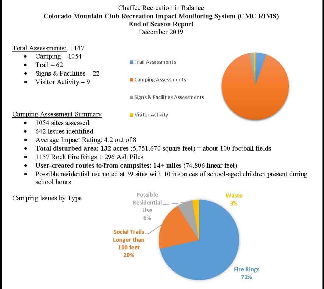
Here’s a link to a report from Chaffee County from July to November. My pet peeve that this could help with are dispersed campers that don’t respect the two week camping ban, or leave their trailers in a spot for what appears to be all of hunting season, taking up the choicest spots and not actually being there.
The image above is from the Chaffee County report. The CMC folks’ intention is to ultimately go national, so please spread the word in your area!
Once, while working for the Eldorado NF, I saw an RV pull up and park on top of an archaeological site that was flagged in pink. As they piled out of the vehicle, it was clear that they were drinking on the way up. I engaged with them and requested that they pick another spot. It turned out that several of them were friendly County Sheriffs officers. They did go find another spot.