Forrest Fleischmann has an interesting Twitter thread on this, worth examining for anyone interested.
How do we decide where we should focus ecological restoration? A recent paper in @nature by Strassburg et al. provided advice that mostly ignored people. We think this is wrong, and Nature has now (finally!) published our response. https://t.co/qVYuv5qUzz
— Forrest Fleischman (@ForrestFleisch1) July 13, 2022
Here’s a quote from a paper by Fleischmann and others that was an answer to another Nature paper (which in turn was responded to by the original authors). Ironically, I couldn’t access the others without a Nature subscription:
Moving forward, land-use priorities could be better identified if scientists and policy-makers work with organizations representing people who live on and manage lands. Top-down approaches to defining global restoration priorities create unrealistic targets and are less likely to succeed in the long-term. At the same time, they risk exacerbating injustice, food insecurity and displacement. Restoration, like any land-management intervention, must ultimately be implemented by people in their distinct social and ecological contexts. Global models that ignore these contexts tell us little about when and where ecological restoration can succeed.
I ran across a job that’s being advertised on LinkedIn for the Wildlife Conservation Society a New York not-for-profit, which seems to be related to zoos. Here’s their program overview:
Program Overview
The overarching goal of WCS’s Forest & Climate Change Program is to help realize the full potential of forests, to deliver climate change mitigation and adaptation, along with national, global and regional biodiversity conservation, through a linked set of programmatic priorities: (1) Protecting Intact forests; (2) Preventing the expansion of deforestation and forest degradation; (3) Reforesting in and around WCS priority landscapes; and (4) Building resilience to the impacts of climate change.
We work both globally and in support of WCS field programs to achieve results at scale, using a varied, adaptive set of tools for impact:
• Using science, including spatial planning and monitoring, to identify priorities for action and measure our impact from a global scale down to specific landscapes, enabling more effective, adaptive implementation;
• Supporting policy reforms to accelerate implementation of each priority at national and regional levels, including through governmental, intergovernmental, and private sector initiatives;
• Catalyzing financial investment and innovation to enable effective and durable progress on each priority, and to help key geographies connect with favorable investment opportunities;
• Fostering economic alternatives at local and national levels to support green economic development for each priority in ways that both protect forests and promote human well-being;
• Building capacity within government and local community partners to effectively lead on implementation and delivery of each priority;
• Employing savvy strategic communications to support and amplify all of the above to inform key decisionmakers and the constituencies that influence them
Ah but what are “intact” forests? Here’s a Nature article
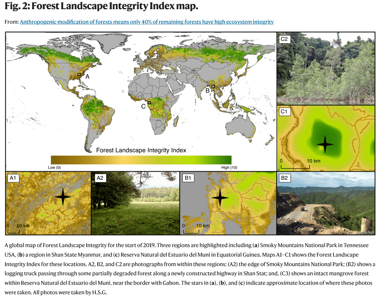
Around a third of global forests had already been cleared by 200038, and we show that at least 59% of what remains has low or medium integrity, with > 50% falling in these two broad categories in every biogeographical realm. These levels of human modification result partly from the large areas affected by relatively diffuse anthropogenic pressures whose presence is inferred near forest edges, and by lost connectivity. We also map a surprising level of more localized, observed pressures, such as infrastructure and recent forest loss, which are seen in nearly a third of forested pixels worldwide.
Conservation strategies in these more heavily human-modified forests should focus on securing any remaining fragments of forests in good condition, proactively protecting those forests most vulnerable to further modification8 and planning where restoration efforts might be most effective39,40,41. In addition, effective management of production forests is needed to sustain yields without further worsening their ecological integrity42. More research is required on how to prioritize, manage, and restore forests with low to medium integrity41,43, and the FLII presented here might prove useful for this, for example, by helping prioritize where the best returns on investment are, in combination with other sources of data (e.g., carbon)44.
The cited paper on production forests (42) says:
The state of the enabling environment for SFM and progress made at the operational level demonstrates commitment to sustainable forest management by governments, industry and communities. At the same time further investment in addressing these limitations is clearly needed to promote and support SFM – particularly in low income forest countries and in large parts of the tropical climatic domain. Overall, the evidence shows a trend favourable to SFM globally that will help ensure forests remain a valued part of our common future.
It almost sounds as if from the cite “sustaining yields without reducing integrity” integrity and yields can coexist? So confusing.
Looking at the map of “Forest Landscape Integrity” it sounds a bit as if some institutional entities think they know best how to manage (or not) landscapes and those living there (human beings). It seems to me to be fairly arrogant. Isn’t colonialism what wreaked havoc on many of those countries in the first place? If a country has fewer intact forests or makes up its own criteria, why is it the international community’s business? In the simplest world of helping communities, the first step is to ask them what they need. Why do these international efforts and NGO’s seem to skip this step?
In addition, count me very mistrusting of a) satellite maps and b) indices of things that aren’t measured well in the first place, and then mooshed together. Many thanks to Forrest and his colleagues for pushing back on this nascent neocolonialism.
I can’t access Forrest’s paper without a Nature subscription. The article he and his colleagues are responding to reminds me of “Strategic Forest Reserves can protect biodiversity in the western United States and mitigate climate change,” Open access. The people and communities affected aren’t in the equation.
https://www.nature.com/articles/s43247-021-00326-0
Abstract:
“Forest preservation is crucial for protecting biodiversity and mitigating climate change. Here we assess current forest preservation in the western United States using spatial data and find that beyond the 18.9% (17.5 Mha) currently protected, an additional 11.1% (10.3 Mha) is needed to achieve 30% preservation by 2030 (30 × 30). To help meet this regional preservation target, we developed a framework that prioritizes forestlands for preservation using spatial metrics of biodiversity and/or carbon within each ecoregion. We show that meeting this preservation target would lead to greater protection of animal and tree species habitat, current carbon stocks, future carbon accumulation, and forests that are important for surface drinking water. The highest priority forestlands are primarily owned by the federal government, though substantial areas are also owned by private entities and state and tribal governments. Establishing Strategic Forest Reserves would help protect biodiversity and carbon for climate adaptation and mitigation.”
Try this one.. https://conservancy.umn.edu/bitstream/handle/11299/228408/GlobalPriorities-finaledits.pdf?sequence=3&isAllowed=y
Thank Gaia that U of Minn has an open-access policy!
I am confused by the use of the image/graphic at the top of this post. The Strassburg paper that Fleischman rebuts is “Global Priorities for Ecosystem Restoration” (https://www.nature.com/articles/s41586-020-2784-9) but the graphic comes from a paper titled “Anthropogenic modification of forests means only 40% of remaining forests have high ecosystem integrity” which lists Strassburg among its many credits. It is unclear in the post which paper is being rebutted and which paper contains the quotes. I could figure that out but it is not easily discerned. Is the inclusion of the job posting intended to highlight the ‘top-down’ conservation problem? The priority “Protecting Intact Forests” (mentioned in the job description) would not seem to me be a cause of negative impacts to local peoples. If a forest is intact then it isn’t being used for agriculture and likely isn’t being used for forest products production. In our own region the protection of intact forest ecosystems is certainly of highest priority for many people and local/regional conservation organizations. IMHO the protection of intact high integrity ecosystems (forest, grassland, wetland, estuary, etc…) should be the highest priority and I can’t see how this negatively impacts any constituency other than those who wish to profit from resource extraction and land speculation. Restoration of damaged or less ecosystems is an entirely different discussion than protection of intact ecosystems.
Regarding the comment “In addition, count me very mistrusting of a) satellite maps and b) indices of things that aren’t measured well in the first place, and then mooshed together. ” I don’t see how that broad generalization is useful. Any large data set should be carefully considered when it is assessed. I read the paper where the graphic came from and find it to be reasonable and useful – no mooshing to my eye. My usual practice with maps is to ‘check the data against known territory’ and see how it measures up. In the case of the Forest Integrity data (you can download it and import into GIS – https://www.forestintegrity.com/download-data) the data looks pretty good for its intended use when checked against western North Carolina. It is important that measurement of the large scale landscape is used in scientific analysis and policy discussions. There’s will always, necessarily, be some opaqueness around the margins but we should be able to rely on our own knowledge and intuition to inform our judgement as regarding usefulness and accuracy.
Nick,
Here is the first para of the methods
To produce our global Forest Landscape Integrity Index (FLII), we combined four sets of spatially explicit datasets representing: (i) forest extent23; (ii) observed pressure from high impact, localized human activities for which spatial datasets exist, specifically: infrastructure, agriculture, and recent deforestation27; (iii) inferred pressure associated with edge effects27, and other diffuse processes, (e.g., activities such as hunting and selective logging)27 modeled using proximity to observed pressures; and iv) anthropogenic changes in forest connectivity due to forest loss27 (see Supplementary Table 1 for data sources). These datasets were combined to produce an index score for each forest pixel (300 m), with the highest scores reflecting the highest forest integrity (Fig. 1), and applied to forest extent for the start of 2019. We use globally consistent parameters for all elements (i.e., parameters do not vary geographically). All calculations were conducted in Google Earth Engine (GEE)60.
That sounds like mooshing to me. “datasets were combined”. I also like to check against my local area, but haven’t figured out how to get it into GIS. Could you help? Thanks!
I guess it depends on what you call mooshing… they describe their methodology and created an index scoring. Without digging too far into the weeds of the scoring rules/rubric I tend to just look at the data in an area I know well (western NC) and see how much sense it makes. Short answer is that it made sense. I could easily identify areas of National Forests aligned with medium integrity, noted a few areas of high integrity that made sense given their remoteness and location, and saw the low integrity areas closely mapped to cities, roads, and river corridors (areas where there are large human and agriculture impacts). Zooming closer I could see smaller scale disturbances within medium intensity areas such as roads and power lines or utility ROW. So that’s enough for me to qualify for reasonable aggregation of large scale datasets. Mooshing, in my eye, is when datasets are combined without reasonable methodology and conclusions are made that are not supported by the quality of the datasets. In this case, we have no better data than satellite imagery and related technologies (IR, thermal, LIDAR, etc…) – so make resonable and considered assumptions and show your work. I’m good with that. I do wish they had better explained the delineation of Low/Medium/High.
In order to get the data into GIS I registered at the link and downloaded the fii_NorthAmerica.tiff which is a GEOTIFF file. Import it as a raster layer. The other format is ArcGIS layer file but I use QGIS and don’t have a way to display that. One thing I did notice is that the Index is at a scale of 1-10 while the tiff has raster values from -3000 to 10000. I am looking for an explanation of that scale from the authors but no response yet.
I don’t think I have GIS.. is there a free version you could recommend?
QGIS is free. Plenty powerful as an alternative to ArcGIS. Of course there’s a learning curve but the documentation is good and there is a large user community and plenty of video how-to examples online. https://qgis.org/en/site/
“In the simplest world of helping communities, the first step is to ask them what they need.” But in the more complicated world of saving the world, why wouldn’t you start with the big picture? I don’t view it as “colonialism” (a disparagement that is too “woke” for me anyway) for scientists to say, “if your criterion for success is X, then do Y.” (Example: “Establishing Strategic Forest Reserves would help protect biodiversity and carbon for climate adaptation and mitigation.”)
Of course, if that is not implementable, it’s not going to be successful, but implementability is determined by other important factors like land tenure and government institutions that these scientists may not be best equipped to address. I don’t see a lot of value in debating this as if some decision-maker would take it out of the box and just do it. To me this is more of an assessment than a plan. I have been more interested in the process for facilitating local decisions that help achieve larger scale goals (especially collaborative conservation planning for connectivity, such as https://largelandscapes.org/).