On March 21, the Council on Environmental Quality provided “Guidance for Federal Departments and Agencies on Ecological Connectivity and Wildlife Corridors” to federal agencies. The Forest Service was a member of the working group that developed this guidance.
“Connectivity is the degree to which landscapes, waterscapes, and seascapes allow species to move freely and ecological processes to function unimpeded. Corridors are distinct components of a landscape, waterscape, or seascape that provide connectivity. Corridors have policy relevance because they facilitate movement of species between blocks of intact habitat, notably during seasonal migrations or in response to changing conditions… Increasing connectivity is one of the most frequently recommended climate adaptation strategies for biodiversity management.”
“To the maximum extent practicable, Federal agencies are expected to advance the objectives of this guidance by developing policies, through regulations, guidance, or other means, to consider how to conserve, enhance, protect, and restore corridors and connectivity during planning and decision-making, and to encourage collaborative processes across management and ownership boundaries. Any existing corridor and connectivity policies or related policies should be updated as needed to align with the objectives in this guidance. Federal agencies should have new or updated policies ready to implement by the first quarter of 2024 and make their policies publicly available. Federal agencies should also actively identify and prioritize actions that advance the objectives set forth in this guidance.”
“Federal agencies should not limit engagement in restoration activities only to circumstances when restoration serves as a mitigation strategy to compensate for adverse impacts from projects or actions. Instead, Federal agencies should consider where there are opportunities in their programs and policies to carry out restoration with the objective of promoting greater connectivity.”
One of the specific “focal areas” listed in the memo is “forest and rangeland planning and management.” “Connectivity and corridors should factor into high-level planning and decision-making at Federal agencies as well as into individual decisions that lead to well-sited and planned projects.” “In carrying out large-scale planning required by statutory mandates (citing NFMA and FLPMA) Federal agencies should consider updating inventories of Federal resources under their associated management plans to assess connectivity and corridors.”
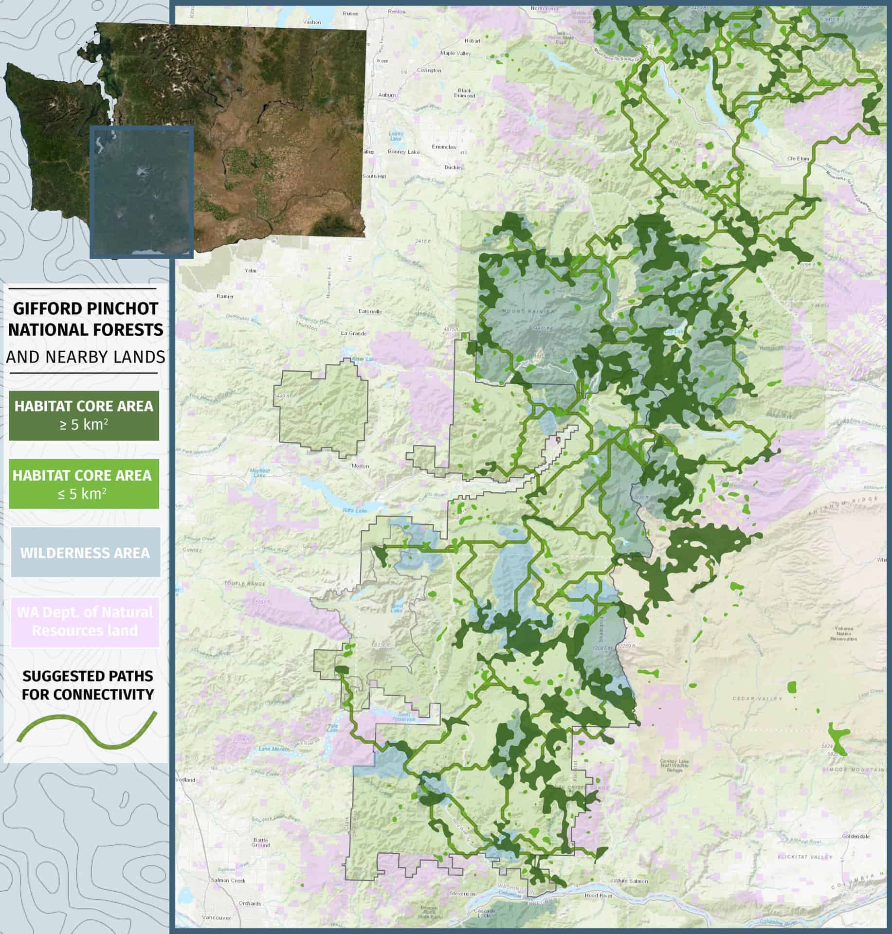
The Forest Service 2012 Planning Rule already includes language requiring that forest plans address connectivity as part of its wildlife viability considerations. I had something to do with that, but I was regularly disappointed in the agency’s unwillingness to “think outside the green lines” about how species occurring on a national forest depend on connectivity across other land ownerships, so I’m always happy to see someone try to make them do that:
“Ecological processes and wildlife movement are not limited by jurisdictional boundaries. Therefore, Federal agencies should seek active collaboration and coordination with other Federal agencies, Tribes, States, territorial, and local governments, as well as stakeholders to facilitate landscape, waterscape, and seascape-scale connectivity planning and management, and consider appropriate collaboration with other nations. Prioritization and strategic alignment of connectivity efforts across partners improves the effectiveness of each entity’s activities and enables larger-scale conservation, enhancement, protection, or restoration to occur.”
“Federal agencies with investments on Federal lands or in Federal waters adjacent to designated areas that may have conservation outcomes (e.g., National Park System units, national monuments, national forests and grasslands, national marine sanctuaries, national estuarine research reserves, wilderness areas, national wildlife refuges, etc.) should explore collaborative opportunities to enhance connectivity across jurisdictional boundaries.”
These kinds of initiatives seem to come and go, but we should at least expect to see the land management agencies tell us what they think under this administration by next year. If anyone happens to notice, let us know!
If the plans don’t include maintaining such connectivity, then they are doomed to fail. Dead forests make very poor wildlife corridors.
We talked about this in Colorado some years ago (corridors). We were waiting, as I recall, for the State to map some corridors. I think they were doing some analysis to see if they could predict future corridors based on climate change (contractors). It seems logical that riparian areas might be good for wildlife, so we could just use those. But then there is linking public ownership, which is good in terms of ease of implementation and also joining recreation trails. But if you join recreation trails, will there be too many people for the wildlife to use it as a corridor?
I think all this (thinking about connectivity and corridors) is a good idea, but like so many things, within the area of connectivity there are still a variety of trade-offs.
It looks like in this 21 report the State is still wanting to do it..I wonder about other states?
https://drive.google.com/file/d/1nKR7fdQpcLHsU_z7XoJz5s7jXdvLwUqs/view
I can’t figure out how to insert an image in comments, but there is a map of state connectivity policy here: https://conservationcorridor.org/digests/2021/06/state-by-state-connectivity-policies-in-the-us/
(But it says legislation has been enacted for Colorado.)
yes, based on your link here is what the legislation says..
Colorado 2019 EO 11 Directs Colorado agencies to identify policy, regulatory, and legislative opportunities to ensure the ongoing conservation of seasonal big game habitat and migration corridors
Colorado 2021 SJR 21-021 Aims to protect and enhance habitat connectivity in the state through the establishment of a working group to develop state policies on corridors, as well as the commission of a report on state corridors and voluntary policies to support willing landowners in improving connectivity
Colorado 2022 SB22-151 Creates a $5 million fund for measures that reduce wildlife-vehicle collisions and reconnect habitat fragmented by roads
Pew says we “lead” in protecting wildlife corridors but ..apparently it funds a position and asks for a commission and the joint resolution is non-binding. According to Pew this lead to “a frenzy” of action.
I did find this elk map from 2017, but I wonder how accurate it.. it maps “specific mappable site through which large numbers of animals migrate and loss of which would change migration routes. This information was derived from field personnel.”
https://geo.colorado.edu/catalog/47540-5d77dba17ddc9900093cf4c3
CPW seems to focus on wildlife corridors crossing roads, which makes sense.
https://coloradowildlife.org/colorado-parks-and-wildlife-issues-science-based-big-game-winter-range-and-migration-corridors-report/
Perhaps our marketing with Pew and the Center for Landscape Conservation outweighs our actual…er… actions? Other than highway crossings which is indeed good work.
https://cpw.state.co.us/conservation/Pages/CON-Transport-Corridors.aspx
How I insert an image in comments… I make a “fake” post and upload the photo, and then copy the html into the comment. Seems to work, albeit kludgy.
Highway crossings are the most obvious way to maintain/improve connectivity, but they don’t obviously involve federal lands, and it is rare to see much involvement from federal land managers. Yet the wildlife is often trying to get from one piece of public land to another, so it seems like those agencies should be viewing wildlife crossings as a management tool that they should be supporting, and in some places maybe leading on (similar to fire management maybe, another cross boundary issue).
Also, we have to hope (especially given the cost of highway improvements), that any private land adjacent to highway structures is protected from further human development. Federal land managers should actively support that as well.
In some places, there may also be needs to facilitate connectivity by not adding developments to federal land, and forest plans should have a connectivity strategy (collaboratively developed during forest planning) that would identify those areas.
Connectivity corridors are a fraught approach, in part because a lot of species disperse randomly.
Narrow corridors are better than nothing, wider corridors are better than narrow corridors, but “permeable landscapes” are far superior.
The Northwest Forest Plan addressed connectivity, (at least for Threatened spotted owls) as follows …
— large reserves with connections to at least two other reserves,
— reserves spaced close enough to allow dispersal,
— maintain some level of habitat suitability in the “matrix” (between the reserves).
For all the critters that can not disperse 10-12 miles like a flying owl, the NWFP relies on the network of riparian reserves and the survey and manage program.
This kind of approach also represents (more by accident than by intent) a pretty good climate adaptation strategy, especially in a topographically complex landscape, where reserves encompass elevational gradients, and the reserve network encompasses latitudinal diversity.
Hopefully this policy can accommodate sound approaches like this.
I agree. I’d distinguish two kinds of corridors. There are those that provide “distinct components of a landscape, waterscape, or seascape” that provide connectivity because those components are what a species naturally prefers to travel through (for species with that kind of affinity, like ungulates). Then there are those that are what’s left of a fragmented landscape that retain enough permeability for a species (including retained corridors connecting reserves), and which is where crossings of fracture zones (esp. highways) should be prioritized for terrestrial species.