I happened to run across something that contradicts Bob Zybach’s repeated assertions that, “these fires have been clearly predicted by me and others because of USFS management policies and Wilderness designations and have zero to do with warming climate or drier fuels.” The Union of Concerned Scientists calculated the effect of warming climate and drier fuels on burned area, and the result from their peer-reviewed analysis is not “zero.”
Climate change is causing hotter, drier conditions that are also fueling these increasingly large and severe wildfires. In particular, vapor pressure deficit (VPD), a measure of atmospheric “thirst,” has emerged as a key way of tracking how climate change is amplifying wildfires because of its role in regulating water dynamics in ecosystems and, together with rising temperatures, contributing to increasing dryness (Box 1).
UCS used a combination of data and modeling to determine how much the carbon emissions associated with 88 major carbon producers (hereafter, the “big 88”) have historically contributed to increases in VPD and burned forest area across the western United States and southwestern Canada (see Methodology).
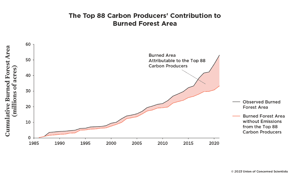
Across western North America, the area burned by forest fires increases exponentially as VPD increases, which means that relatively small changes in VPD result in large changes in burned forest area. The observed rise in VPD has enabled a steep increase in the forest area that has burned across the region since the mid-1980s. Since 1986,1 a cumulative 53.0 million acres of forest area has burned across western North America as VPD has risen. Without emissions tied to the big 88, the rise in VPD would have been much smaller, and 33.3 million acres (IQR 27.7 million–38.5 million) would have burned (Figure 4). That means that 37 percent (IQR 26–47 percent) of the cumulative burned forest area from 1986 to 2021 is attributable to emissions from the big 88. This represents nearly 19.8 million acres of burned forest area, or an area roughly the size of Maine.
You can criticize UCS for being agenda-driven (and we’ve talked about the limitations of “burned area” as a metric), but I’d challenge Bob or others to provide a similarly peer-reviewed research paper that attributes fire effects to his chosen causes.
I don’t buy it; correlate the beginning and intensification of WFU in federal policy, and the “change” in firefighting response. Up until the late 1990’s, the FS (anyway) put most emphasis on putting fires out while they were small, and doing so quite aggressively. These factors must have some way being factored into the graph. Otherwise, it is a nice picture – of something…..
There are three primary reasons for the horrific destruction due to unplanned wildfires over the last 15 years, especially. And it’s a tie for the top spot. See page 15 of “A Call to Action.” I don’t spend a lot of time quibbling about the top three. But we better address these three, for sure. The lack of care [i.e., maintenance; management] for our forests [forest are more than just trees] is clearly a major culprit. We all know this. Right now, just for the Forest Service, the annual budget to effectively address this issue is about $3 billion short. Yes, $3 billion. Yet we seem okay with spending +$1 million/hour fighting fires with absolutely no end in sight. Annual damages from wildfires are approaching $1 trillion. Let’s do the math. What would +$3 billion for the next 5-7 years contribute to reducing suppression costs and damages? Clearing more than $3 billion beginning in years 6-7; it’s not even a close call. I have found myself not debating the “top three” reasons any longer. I just wish we could band together and be an influencing force to effectively address this national emergency. Properly coalesced, we certainly have the position power to do exactly that.
Very respectfully,
I agree that, in addition to the effect of temperatures, it’s not hard to make the case that there should be a correlation between the number of standing trees and burned area. But it’s harder to make the case for how much more logging we should be doing than we have been, especially in light of the adverse effects (and doubtful benefits) of removing larger trees. That’s the research I’d like to see, but it really plays out in site-specific projects that have to make that case on their own.
What do you mean by logging exactly? I see some possibilities
cutting trees and leaving them.. or burning in piles
cutting trees and removing them, whether or not they are used for personal or commercial purposes
I also don’t understand what you mean by removing “larger” trees.. larger than the trees they are next to? Commercial sized?
“Larger” = ecologically rare and valuable. Also, most people seem to agree that larger trees are more fire resistant and removing them is therefore not likely to make a forest more fire resistant. Both are reasons to not cut them down. The instances where overstory trees pose a fire threat should be viewed as the exception rather than the rule, and a project should have to make that case based on site-specific information. (Instead of simply labeling every timber sale as “fuels reduction.”)
They do make site specific cases..that’s what silvicultural and fuels prescriptions are??
Is a mature white fir next to a resilient P pine “ecologically rare and valuable)? Is a large white fir ever “fire resistant”?
I think we’ve seen enough disputes about the fire protection value of removing large trees to think that agency administrative records are not making that case.
Or maybe they are making the case adequately if the FS is winning in court..
It would be nice if the correlation was just the number of standing trees and burn areas. The fuel mixture (fine up to large), structure, topography, and weather all play a part in the the burn characteristics. An examination of the Oregon Rum Creek Fire fire pattern and behavior makes this very clear. Some of the areas that had extreme stand replacing burn behaviors were very heavily managed/treated. While right next to it was very thick high density stands that burned at low intensity or not at all. Other areas that have had no modern harvest/treatment showed a matrix of burn from no/low to medium to high burn severity. What is obvious is the time frame when the fire took off after an agressive initial attack was due to weather/wind and and all fuels seemed to burn. Once the weather calmed down then fuels and topography seem to be the drivers. And the suppression effort I’m sure played a part. There was a lot of aerial support (retardant) on some of the areas with mixed results (limited access for ground crews to follow up after drops in the northwest section).
So I would be surprised if there would be a simple x number of trees vs burn area equation.
So I don’t think it’s 0, but I know the UCS doesn’t know, in fact no one knows for sure because all the changes are too difficult to separate and in fact, there aren’t even data for many of the variables.
Also I looked at this and I didn’t see exactly how it was peer-reviewed.
When I know that they don’t know… and yet they claim they are Very Sure!!! I wonder what’s behind it.. Do they really not know how things work (scary) or don’t they care (possibly scarier?)
“The authors thank three anonymous scholars who reviewed either this report or the associated publication in Environmental Research Letters.”
Kitzberger T, Falk DA, Westerling AL, Swetnam TW (2017) Direct and indirect climate controls predict heterogeneous early-mid 21st century wildfire burned area across western and boreal North America. PLoS ONE 12(12): e0188486. https://doi.org/10.1371/journal.pone.0188486
Buch, J., Williams, A. P., Juang, C. S., Hansen, W. D., and Gentine, P.: 2023. SMLFire1.0: a stochastic machine learning (SML) model for wildfire activity in the western United States, Geosci. Model Dev., 16, 3407–3433, https://doi.org/10.5194/gmd-16-3407-2023.
Second, I’d add that in contrast to “Weather conditions at local and regional scales during the fire season are dominant factors influencing fuel flammability and annual area burned [17–20].” I’d say that weather, the efficacy of suppression, and suppression strategies and tactics are dominant factors influencing annual area burned.
It’s kind of like… predicting river floods assuming no levees.