Landscape Scale Assessments- Rim of the Valley-Who’s on First?

On this blog, there have been many discussion of planning over different spatial scales and ownerships. In yesterday’s AP story in the San Jose Mercury News about an assessment in Southern California toward an all-lands approach.

PASADENA, Calif.—The National Park Service is beginning a lengthy study on ways to conserve corridors of wilderness around the intense urbanization of Los Angeles.

Officials suggested Friday that the outcome would likely be a proposal to Congress for collaborative management between the National Park Service, U.S. Forest Service and public-private partnerships, but property rights advocates charged that it will lead to a land-grab for a national park.

The story included this interesting (hopefully) misspelling:

Smeck said the process will include a series of meetings this summer to gather public input and identify stakeholders. Officials will determine which areas rise to national importance and study how the Park Service might fight in with existing entities doing conservation work.

A different take on the same thing showed up yesterday in the Pasadena Star

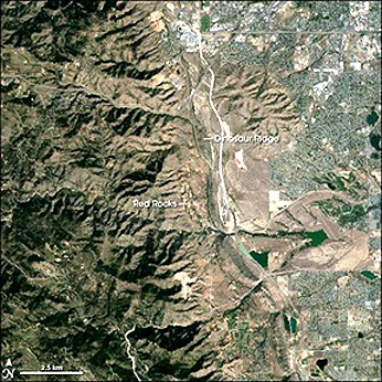
PASADENA – U.S. Forest Service officials announced Friday the beginning of a five-year study of an open space that stretches from the Santa Monica range to the San Gabriel Mountains.

The Rim of the Valley Corridor includes private and public land from the Santa Monica Mountains, Santa Susanna Mountains, San Gabriel Mountains, Verdugo Mountains and San Rafael Hills.

The Forest Service wants to bring the lands under federal protection and would study the possibilities of trail development, land acquisition and preservation of wildlife corridors that connect different sections of open space in the area.

Read more: http://www.pasadenastarnews.com/news/ci_15231347#ixzz0pzxqGQ9l

It’s interesting how the two different stories described the role of the Park Service compared to the Forest Service. The creative aspect is to take an “all lands” approach and for only $500K over 4 years, and the fact that is is not part of an NFMA process. It is also interesting that the AP story talks about “wilderness” in a kind of generic way..

“The question then became decades later, would we feel the same foresight? Would we be able to anticipate the same kind of growth in population, the same need to proactively try to preserve this incredible wilderness area?” said Schiff, whose district includes foothill communities along the wilderness areas.

So it is not particularly clear from these news stories if the assessment is for land allocations within the Forest Service land, to identify potential acquisitions and easements, to give the Park Service a larger role in collaboration, to “protect wilderness” or all of the above.

Boundaries, Eh.


Photo by Nie.

A Canadian Whale? A Vancouver Canucks fan? Drink Labatt’s blue? Smoke du Maurier’s at a Tim Horton’s?  Other clues….

I spent part of last week at a workshop focused on “Integrating and Applying Conservation Science for Transboundary Coastal Temperate Rainforests.”  Basically a lot of intense time thinking about the Tongass in Southeast Alaska and the Mid-to-North Coast of British Columbia (including the Great Bear Rainforest, Haida Gwaii, etc.). 

I was struck by how similar the discussions were to those here on the blog.  People on both sides of the border are struggling with so many similar planning, management, conservation, and community issues.  Lots of the same stuff, but in a much different governing context.

One of the most obvious themes of the workshop is the importance of boundaries in forest management and conservation.  That this place is ecologically connected is beyond question.  It is collectively the largest temperate rainforest in the world.  The region also faces some similar threats, and not just those from the “timber wars” that have long characterized the region. 

Similarities and connections notwithstanding, the region is dominated by boundaries.  Consider just two.  First, there is the obvious international boundary.  So strong is this demarcation that is has impeded the sharing of information and makes it difficult to learn lessons from one another.  The workshop was designed to start chipping away at this problem. 

Another boundary is that between terrestrial and marine conservation.  One of the things making the Tongass so different (and special) compared to other national forests is its marine interactions and context (an archipelago).  Same goes for coastal/island BC.  Take, for example, the fascinating relationship between salmon and forests (a compelling story about why we need more holistic, integrated planning:  background on the “salmon forest project” and associated EquinoxSalmonArticle). Despite these interactions, approaches to protected areas most often focus on terrestrial reserves, and ignores the marine. 

There are other boundaries as well, from disciplinary to professional that play out in sometimes baffling ways.  Of course, a lot of this is old ground, and we don’t need to re-hash all the ecosystem management stuff of the past.  But the situation does raise a couple interesting questions from a forest planning standpoint, including:

1) Does an “all-lands” approach (as articulated by the USFS in its planning process) necessitate “due consideration” of adjacent lands in Canada?  (The NOI states that “plans could incorporate an “all lands” approach by considering the relationship between NFS lands and neighboring lands.  The threats and opportunities facing our lands and natural resources do not stop at ownership boundaries.” 74 Fed. Reg. 67,169. 

2) Are there examples of integrated protected lands/marine areas that are instructive from a wastershed/planning perspective? (The NOI states that “land management plans could emphasize maintenance and restoration of watershed health…”.

Water and Watersheds- Unifying Principle for a New Planning Rule?

Guest post by Jim Furnish, former Deputy Chief for National Forest Systems, USDA Forest Service

Why Is Water So Important?

The connection between forests and water has long been recognized, and was at the core of why national forests were created. The Organic Act of 1897 speaks to “favorable conditions of water flow” (which we would articulate differently today), and the strong inference is to both quality and quantity. Forests and their waters were under clear threats from rampant logging, grazing, and mining. Today, although such overt abuses have been stopped, the value of clean abundant water flowing from public land is greater than ever.

Watersheds behave much like a human veinous system, serving every part of the landscape and ushering water out and away through ever larger streams. Water is a direct and inerrant reflection of the health of the landscape — it cannot lie. It is the lifeblood of the landscape, thus, biota is usually bunched and concentrated in and near water. A century of conservation has no doubt served to avert degradation, yet population and commercial pressures continue to impact watershed health.

Is watershed restoration necessary? The underlying question is important — is there anything to restore, and, if yes, how/why did it get that way? On national forests, did the Forest Service play a causal role? The response to these questions draws sharp differences, often breaking along ideological lines. But what does the land say?

Invasive species, degraded fish stocks, threatened species, loss of riparian health — no matter your ideology, all these speak plainly to the reality that things are not as they should be, no matter the cause. What niche should national forests occupy as it relates to reasonable public expectations for watershed health? I would hope the Forest Service would aspire to a high calling. It should be noted that severity varies greatly, and some watersheds remain in great shape, while others are in poor health.

Today, watershed restoration must be an essential unifying principle for land managing agencies — and an important element in an effective and useful planning regulation. Water is a crucial essence for almost all land management considerations.

Earth to FS Planning: Get a Blog!

Yes I know that the FS thinks it has a Planning Rule blog. But it doesn’t. Not a real blog anyway. All it has, so far, is a poor excuse for a comment aggregator. The other day I decided to leave a comment on Peter Williams’ recent post on the “official blog”. Guess what? The so-called blog won’t accept comments that include paragraph breaks. No HTML is allowed. And, best I can tell, even simple “http” references are not converted to active links. So I decided that until and unless the FS is willing to at least fix the paragraph breaks problem—or tell folks how to use the blog so that it will include “breaks”—I will just use real blogs outside the “official” smokescreen. Here is the comment I intended to post as a response to Peter, slightly edited:

Here is my “take” on Peter Williams’ final two questions, restated a wee bit:

How might the planning rule provide for an all lands approach and address the contribution of NFS lands to local communities?

  • How can the new planning rule, by itself or as a road map for developing forest plans, reflect the interdependency of social, economic, and ecological systems in a way that supports sustainable management of national forests and grasslands?
  • How can it help provide or ensure opportunities for goods and services to support vibrant rural, regional, and national economies?

My guess is that any planning rule that is developed in the long tradition of “rules” dating back to 1979 will not be helpful in achieving the goals embedded in the questions. Why? Because the focus of each “rule” has always been on developing a “Forest Plan” as if there were wide discretion in that process and “as if” the forest administrative unit made sense as an overall “catchall” for decision-making. Neither is the case.

One problem is that there can not be wide discretion in forest-level decision-making if only because the ecosystems embedded in each administrative unit of the national forest system are themselves part of broader ecosystem wholes, e.g. larger watersheds, larger “basin and range” systems, both, and more. This means that what works for sustainability (instead of against) re: “forest subsystem contributions” to ecosystems must be informed by the needs of broader wholes. So too with social systems. An “all lands approach” must be scaled, hierarchically, to guide development of plans at subscales. Maybe a NFMA “rule” can address such, but we haven’t seen one yet. Only with such an adaptive management assessment information system could forest-level decision-making begin to make any sense. And the ecosystems/social systems scale problem is but one of many problems that impede wide discretion in decision-making. Another is what I call the “wicked problem” problem.

The Forest Service has never (to my knowledge) addressed “wicked problems” (Wikipedia link: http://en.wikipedia.org/wiki/Wicked_problem. Such problems were first introduced to the Forest Service in 1986 by Allen and Gould (Journal of Forestry) and to the world by Rittel and Webber in 1973 (Policy Sciences). Anyone who has studied forest management problems knows that they are indeed politically wicked and cry out for approaches much different from the “comprehensive rational planning” approach that the Forest Service always gravitates toward. Even when dressed up with terms like “adaptive” or “adaptive management” the reality of the approaches used always have rational-planning at their core.

One thing is certain when dealing with wicked problems: You can only hope to accomplish anything when you are able to define the scope the problem (time, space, issues, etc.) into “decision containers” that people (stakeholders, administrators, etc) can get their minds around. It seems that traditional “forest plan” containers are hopelessly over-filled when land management zoning, land management goals and objectives, program goals and objectives, and related “standards and guidelines” are all in play — and “in play” in a spatial container that isn’t really relevant to many of the objectives at hand. I have long felt that rational planning approaches simply can’t work. Here is how I put it in my Epistle to the Clinton-era Committee of Scientists (link: http://www.fs.fed.us/eco/eco-watch/cos_greenplans.html) , written when I was an employee of the Forest Service:

… [W]e have failed to learn the lesson that there is a difference between complex problems and wicked problems (see: G.M. Allen’ and E.M. Gould. 1986. “Complexity, wickedness, and public forests.” J.For 84(4):20-23, also Henry Mintzberg. 1994. The Rise and Fall of Strategic Planning). According to Allen and Gould, politically wicked problems can not be solved by any multi-step planning process designed to “collect more data, build bigger models, and crunch more numbers … [expecting that] surely the right answer would be forthcoming.” Allen and Gould suggest that the Forest Service’s general operating norm for planning–more data, fancier analysis, more computing power, more scientists–reflects a “naive hope that science can eliminate politics.” This problem went unresolved–is still unresolved–because [Forest Service] ‘professional arrogance’ wouldn’t allow [the agency] to admit that national forest management and planning is ‘political’.

Why not try adaptive management, better still Adaptive Co-Management (Resilience Alliance Link: http://www.resalliance.org/2448.php) when thinking in terms of an “all lands approach”. Note here that the adaptive management I’m talking about is multiple-scale oriented, addresses wicked problems, and involves double loop learning (More here: http://en.wikipedia.org/wiki/Organizational_learning). Maybe such adaptive co-management can be and will be fit into the NFMA “rule” rewrite. But I doubt it. As I mentioned in an earlier post, I hope I am proven wrong.

Final thought: If adaptive co-management is to work, decision-makers will have to constantly check and “be checked” to make sure that decisions (cumulatively) aren’t afflicted with policy “decision traps.” E.g. a set of decisions might be afflicted with “policy drift” — a “tyranny of small decisions” that eventually runs counter to policy aims due to the cumulative effects of sequential or segmented decisions.
The New Energy Economy and Forest Plans

The process that we determine whether public or private land for transmission lines or a combination, is environmentally, socially and economically “best” for new powerlines is critical in our new energy economy is a key policy question. See today’s story about Governor Freudenthal’s concerns. One thing that’s for sure is that forest plans in and of themselves can’t keep up with these requests, although management areas or themes or suitability (lines on maps) may be helpful concepts when these questions come up.

Development, Forest Planning and an All Lands Approach

In the news over the weekend,  we have seen stories on the the move toward community forests in the Oregonian, and an article in the New York Times entitled “Housing Boom Near Preserves Hamstrings Conservation” on a study of the housing boom near forests and other conservation areas.

Given the pressure of development, and the desire for forest planning to take an “all lands” approach, what kinds of things should a planning rule or a forest plan contain?

Should a precursor to a forest plan be a mapping of wildlife corridors and linkages?