Whitebark pine still waiting on ESA

Whitebark pine are being killed by a disease, white pine blister rust, as well an insect, the mountain pine beetle, according to the Fish and Wildlife Service.

Meanwhile, other species of trees have crowded out whitebark pine due to fire suppression efforts over the past century, the agency said.

The Wildwest Institute and the Alliance for the Wild Rockies couldn’t convince the 9th Circuit Court of Appeals that whitebark pine should be a priority for protection under the Endangered Species Act.  The Fish and Wildlife Service found whitebark pine to be warranted for listing but precluded by higher priorities.  The priority system the agency uses for considering additional species made whitebark pine a priority for listing, but the court held that the Service doesn’t have to follow its own priorities.  Whitebark pine remains a candidate species.

Are Trump’s climate censors at the door of forest planning?

In conjunction with publishing its notice of intent to prepare an EIS and draft forest plan, the Gila National Forest revealed a bit of the thinking going on on at least one national forest about whether they should continue to address climate change in the forest planning process.

Throughout the assessment process, the Forest team took a close look at the significant effects of climate change on the Gila. According to Schulz, directives from U.S. President Donald Trump to other agencies to release no evidence of climate change they find have not been represented in the assessment report.

“The documents still do talk about climate change,” he said. “You will see that. We will just see how this all works moving forward. There are a lot of aspects we will still be talking about using some aspects of terminology, like ‘drought.’ There is clearly strong local interest in managing the effects of climate change.”

So maybe they would address climate change without saying the words?  At least they’re moving forward, for now.  It’s actually hard to imagine major backsliding in forest planning since the planning rule requires the use of the best available scientific information, and I think the Forest Service has been a leader in trying to apply climate change science.  The point about local interest is important, too.  If nothing else, if someone brings it up, the agency can’t arbitrarily dismiss it.

Summary of fire debate points

The latest from Headwaters lays out their point of view on several topics that have been discussed a lot on this blog (with cites).  The 2016 paper is posted in full and is pretty short and sweet.  The key points:

1. Fire size and frequency will increase under a warmer and drier climate

2. Fuel reduction on federal lands will do little to reduce acreage burned and homes lost

3. Not all forests need restoration

4. High severity fires often have ecological benefits

5. Insect outbreaks do not necessarily make fires worse

6. Land-use planning can reduce wildfire risk

7. Managing more fires to burn safely can reduce risk and increase ecological benefit

Case closed?

Carbon is Not the Enemy (from Nature)

webnature_graph_carbon_17-11-16

I liked that this seems to be a more positive way of looking at what we can do to reduce climate change…what McDonough does (in an essay in Nature) proposes is a more holistic way of looking at carbon.. looking at the different uses and values of carbon.

“Such terms highlight a confusion about the qualities and value of CO2. In the United States, the gas is classified as a commodity by the Bureau of Land Management, a pollutant by the Environmental Protection Agency and as a financial instrument by the Chicago Climate Exchange.”

Here’s the link.

Natural Range of Variation in the southern Sierra national forests

So what did the Sierra, Sequoia and Inyo do to apply this planning rule requirement to terrestrial ecosystems?  I’ve just reviewed the draft plan and DEIS, and I don’t think I’ve got a good answer.  They don’t directly say what NRV is or how they determined it (at least in the places I’ve looked).

The Bio-Regional Assessment says this (p. 39):  “NRV only was not used because at this time conditions are far removed from them in terms of fire regime, and even a modest shift toward that level of resiliency would benefit ecological integrity and is more feasible in a short period of time. The planning rule specifically provides for using ecological integrity based on measures other than NRV where this is the case.”

This view is supported by the Planning Handbook (1909.12 FSH 12.14b) (but again, the Handbook does not appear to be supported by the Planning Rule): “In some situations, there is not enough information to understand the natural range of variation under past disturbance regimes for selected key ecosystem characteristics or the system is no longer capable of sustaining key ecosystem characteristics identified as common in the past based upon likely future environmental conditions. In these cases, the Interdisciplinary Team should establish an alternative ecological reference model for context for assessing for integrity by identifying the conditions that would sustain these key ecosystem characteristics.”  However no “alternative ecological reference model” was documented.

For terrestrial vegetation the Bio-Regional Assessment then apparently ignores itself (p. 98):  “Under the 2012 Planning Rule, “natural range of variability” is a key means for gauging ecological integrity. Ecosystem sustainability is more likely if ecosystems are within the bounds of natural variation, rather than targeting fixed conditions from some point in the past (Wiens et al. 2012, Safford et al. 2012). Safford et al. (2013a) compiled comprehensive, scientific literature reviews on natural range of variability, and these are the primary basis for the summary below.”  The summaries conclude whether ecosystems are within or outside of NRV, but they don’t say what NRV is.

The Sierra Assessment says this (p. 17):  “Comprehensive, scientific literature reviews on natural range of variability were compiled. The following is an overview. Consistent with trends across the entire assessment area, terrestrial ecosystems in the Sierra NF are predominantly outside the natural range of variability (NRV) for key indicators of ecological function, structure, and composition. First, nearly half (44 percent) of the area of the Sierra NF dominated by woody vegetation (or 76 percent of montane coniferous forests) is in a highly departed condition with respect to the historic fire return interval, burning at frequencies that are significantly longer than pre-settlement fire regimes (Safford and van de Water 2013). The Sierra NF has missed an average of three to four fire return intervals across all vegetation types dominated by trees or shrubs (Safford and van de Water 2013). Subalpine forests are the exception, burning at intervals that within one or two fire return intervals.”

The Bio-Regional Assessment describes fire history on p. 33, and the Sierra Assessment appears to use historic fire intervals as a reference, but what are the vegetation conditions that would produce the desired fire intervals (which would be the NRV for vegetation)?  I didn’t find a document that says what what vegetation NRV is or how it was determined, or even what the “key indicators” are.  The draft plan does have desired conditions for vegetation, and the DEIS says those are or are based on NRV.  The quickest way to get a feel for these DC=NRV is Tables 1-7 in the draft revised forest plan.

What is NRV for vegetation characteristics?  Are they based on the best available science? Did they properly use historic reference conditions?  What was the reference period? Did they consider climate change?  Are these sustainable desired conditions?  Do they comply with the requirement for ecological integrity?   Do they provide conditions needed for at-risk species? You’d think the answers to these important questions would be easier to find, but I’m out of time.  Maybe someone else can find some answers on the revision website somewhere.

Science consistency review on the southern Sierra national forests

The draft revised Sierra, Sequoia and Inyo national forest plans include aggressive restoration programs across the forest, including logging areas of existing old forest structure to protect old forests and associated wildlife species.  The Forest Service has asked (unidentified) reviewers to look at the draft forest plans and draft EIS and address these questions in the first science consistency review conducted under the 2012 planning rule (it is an optional process under associated agency policy):

1. Has applicable and available scientific information been considered?

2. Is the scientific information interpreted reasonably and accurately?

3. Are the uncertainties associated with the scientific information acknowledged and documented?

4. Have the relevant management consequences, including risks and uncertainties, been identified and documented?

Here are some of the topics being addressed:

• Vegetation: Forest Resilience, Seral stage distribution, Effects of post-disturbance harvest, and Impacts on native vegetation.

• Fire and Fuels: Fuels management and community protection, Current fuel loading, Current and future wildfire trends, Effectiveness of treatments for fuel reduction.

• Wildlife and Habitat: Impacts to wildlife and their habitats, terrestrial and aquatic, Protection of old forest and associated species, Threatened and endangered species habitat requirements and availability, Species of Conservation Concern habitat requirements and availability.

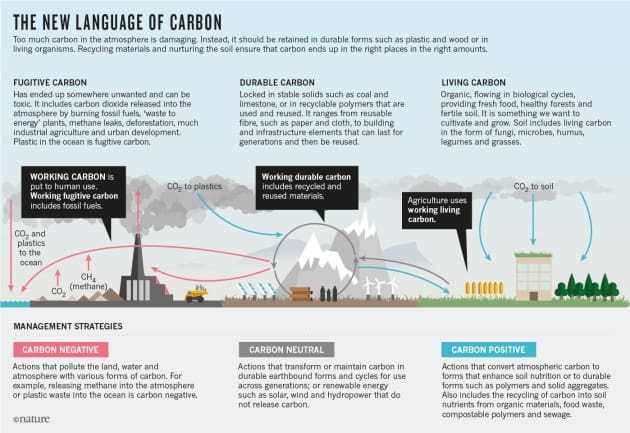
• Climate Change: Current and projected trends, Effects on wildlife habitats and populations, Effects on carbon sequestration and carrying capacity

Given the debate on this blog surrounding these issues, the results should be interesting.  However there is no commitment here to any public release or discussion of the results.  The comment period on the draft EIS closes August 25th.  The results of this review were scheduled to be available in August.  “The technical experts (on the planning team) will review the report, consult and address any concerns from the review team, and incorporate any recommendations that would benefit the final EIS.” 

Given the debate on this blog surrounding these issues, the results should be interesting.  However there is no commitment here to any public release or discussion of the results.  The comment period on the draft EIS closes August 25th.  The results of this review where scheduled to be done in August.  “The technical experts (on the planning team) will review the report, consult and address any concerns from the review team, and incorporate any recommendations that would benefit the final EIS.”

Here is the revision website.

Utah to sue to get federal lands

Or at least they’ve set aside the money to pay for it (the lawsuit, not the land).  So what are they waiting for?  Maybe they are hoping a Trump administration would make it unnecessary?

(Some of you would probably also like Heartland’s take on forest fires.  “But now, the Department of the Interior misinforms us, ‘climate change is making it worse. Wildfire seasons are now hotter, drier and longer than in the past.’ Sure they are. Wanna buy a bridge?”)

Helping realtors think about climate change

Previous posts have discussed how where we choose to live contributes to the effects of climate change, both by promoting carbon lifestyles and building in locations at risk.  The Missoula Organization of Realtors hosted a conference on the effects of climate change on their industry.  This is a step in the right direction.  Missing from the presentation though were the perspectives on urban interface living from local government planners and public land managers.

Climate Change Update

I shot this picture from the top of Mammoth Mountain Ski Area, along the Sierra Crest. At the end of July, there should be a lot more snow and ice (including small glaciers) in this view of north-facing slopes. The view behind me was obscured, for three afternoons, by a Fresno area wildfire, with smoke drifting up over the crest. I’m sure that the groundwater levels are extremely low, as well.

P9288472_tonemapped-web

Water levels at Mono Lake also continue to drop, exposing more of the famous Tufa formations, created by the fluctuating lake levels, over tens of thousands of years.

P9288543_tonemapped-web