Why We Need to Salvage and Replant the Rim Fire

Greg asked why we should bother with salvage logging on the Rim Fire, and I tried to explain how bear clover would dominate landscapes. He also seemed confused about modern salvage projects, here in California. Everything, here in California, is fuels-driven, as wildfires happen up to 13 times per century, in some places in the Sierra Nevada.

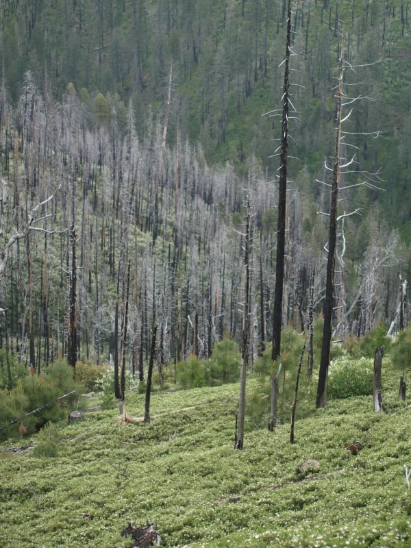
This picture shows how dense the bear clover can be, blocking some of the germination and growth of conifer species. Additionally, bear clover is extremely flammable and oily, leading to re-burns. This project also included removing unmerchantable fuels, including leaving branches attached. Yes, it was truly a “fuels reduction project”. You might also notice how many trees died, from bark beetles, after this salvage sale was completed. Certainly, blackbacked woodpeckers can live here, despite the salvage logging. Hanson and the Ninth Circuit Court stopped other salvage sales in this project, in favor of the BBW.

P9256073-web

When you combine this bear clover with a lack of fire salvage and chaparral brush, you end up with everything you need for a catastrophic, soils-damaging re-burn and enhanced erosion, which will impact long term recovery and the re-establishment of large tree forests. Actually, there has already been a re-burn within this project since salvage operations in 2006. Salvage logging greatly reduced that fire’s intensity, as it slicked-off the bear clover, but stayed on the ground. Certainly, if the area hadn’t been salvaged, those large amounts of fuels would have led to a much different outcome.

Now, if we apply these lessons to the Rim Fire, we can see how a lack of salvage in some areas within the Rim Fire will lead to enhanced future fires, and more soils damages and brushfields. When the Granite Fire was salvaged in the early 70’s, large areas were left “to recover on their own”, in favor of wildlife and other supposed “values”. When I worked on plantation thinning units there, those areas were 30 year old brushfields, with manzanita and ceanothus up to eight feet high. Those brushfields burned at moderate intensity, according to the burn severity map. Certainly, there were remnant logs left covered by those brushfields, leading to the higher burn severity. It was the exact same situation in my Yosemite Meadow Fire example, which as you could see by the pictures, did massive damage to the landscape, greatly affecting long term recovery. Here is the link to a view of one of those Rim Fire brushfields, surrounded by thinned plantations.

https://maps.google.com/maps?hl=en&ll=37.999904,-119.948199&spn=0.003792,0.008256&t=h&z=18

I’ve been waiting to get into this area but, I expect the fire area will remain closed until next year. The plantations were thinned and I hear that some of them did have some survival, despite drought conditions and high winds, during the wildfire. In this part of California, fuels are the critical factor in wildfire severity. Indians knew this, after thousands of years of experience. They knew how to “grow” old growth forests, dedicating substantial amounts of time and energy to “manage” their fuels for their own survival, safety and prosperity. Their preferred forest included old growth pines, large oak trees, very little other understory trees, and thick bear clover. Since wildfires in our modern world are a given, burning about every 20 to 40 years, we cannot be “preserving” fuels for the next inevitable wildfire.

We need to be able to burn these forests, without causing the overstory pines to die from cambium kill, or bark beetles. That simply cannot be done when unsalvaged fuels choke the landscape. We MUST intervene in the Rim Fire, to reduce the fuels for the next inevitable wildfire that WILL come, whether it is “natural”, or human-caused. “Protected” old growth endangered species habitats may now become “protected” fuels-choked brushfields, ready for the next catastrophic wildfire, without some “snag thinning”.  We cannot just let “whatever happens”, happen, and the Rim Fire is a perfect example of “whatever happens”. Shouldn’t we be planning and acting to reduce those impacts, including the extreme costs of putting the Rim Fire out, and other significant human costs? Re-burns are a reality we cannot ignore, and doing nothing is unacceptable. Yes, much of the fire doesn’t have worthwhile salvage volumes, and that is OK but, there are less controversial salvage efforts we can and should be accomplishing.

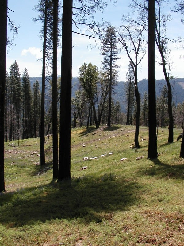
Here is an example of salvage and bear clover, six months after logging with ground-based equipment. This looks like it will survive future wildfires. You can barely even see the stumps, today! The bear clover has covered them.
clean_salvage-06

Science Policy Forum: Managing Forests and Fire in Changing Climate

Scientists claim policy focused on fire suppression only delays the inevitable. Read more here. The opening paragraph and names of the authors are below.

With projected climate change, we expect to face much more forest fire in the coming decades. Policymakers are challenged not to categorize all fires as destructive to ecosystems simply because they have long flame lengths and kill most of the trees within the fire boundary. Ecological context matters: In some ecosystems, high-severity regimes are appropriate, but climate change may modify these fire regimes and ecosystems as well. Some undesirable impacts may be avoided or reduced through global strategies, as well as distinct strategies based on a forest’s historical fire regime.

Authors: S. L. Stephens, J. K. Agee, P. Z. Fulé, M. P. North, W. H. Romme, T. W. Swetnam, M. G. Turner

Forest Modeling & Global Warming: Academic Job Security

Here is a presentation that will be made by Oregon State University professors to Congress later today in Washington DC:

Preserving the Role of Forests in Mitigating Climate Change

The majority staff of the Senate Environment and Public Works Committee, the Senate Energy and Natural Resources Committee, and the Senate Agriculture Committee encourage you to attend a briefing where forest-carbon scientists will discuss the role of carbon in forest management and climate change mitigation in relation to the President’s Climate Action Plan and to carbon strategies underway by federal land managers and of consideration to members of Congress.

When: September 26 at 2 pm

Where: Senate Environment and Public Works Committee, 406 Dirksen Senate Office Building

Who: Beverly Law, Mark Harmon, Dominick DellaSala

America’s forests play a critical role in addressing carbon pollution, removing nearly 12 percent of total U.S. greenhouse gas emissions each year. In the face of a changing climate and increased risk of wildfire, drought, and pests, the capacity of our forests to absorb carbon is diminishing. Pressures to develop forest lands for urban or agricultural uses also contribute to the decline of forest carbon sequestration. The Administration and Congress are working to identify new approaches to protect and restore our forests, as well as other critical landscapes including grasslands and wetlands, in the face of a changing climate.

Presenters will focus on four key questions:

1 – What does the best science say about the role of forest ecosystems in climate change mitigation and adaptation planning and how can forests be best managed to optimize their carbon uptake and storage potential?

2 – What role do natural disturbances (fire, insects) play in forest carbon budgets and how do forest management strategies such as thinning affect carbon budgets on federal lands?

3 – How does forest carbon management and forest carbon preservation fit with the President’s Climate Action Plan and with efforts of federal land managers to treat carbon as a “multiple use” on federal lands?

4 – What role has federal lands management such as the Northwest Forest Plan and the forest planning rule had in managing forests for carbon storage and uptake?

Presenter Biographies

Mark E. Harmon is the Richardson Chair and Professor in the Department of Forest Ecosystems and Society at Oregon State University and co-director the Cooperative Chemistry Analytical Laboratory (CCAL). From 1999 to 2006 he served as the lead principal investigator for the NSF-sponsored H. J. Andrews LTER and lead OSU scientist for the H. J. Andrews Experimental Forest in Oregon.  He has published over 120 peer-reviewed journal articles on a topics ranging from tree growth and mortality, decomposition of wood in the natural environment, management of coarse woody debris, carbon dynamics of forests, disturbances, and ecosystem modeling.

Dr. Beverly Law is Professor of Global Change Biology & Terrestrial Systems Science in the College of Forestry, and an Adjunct Professor in the College of Oceanic and Atmospheric Sciences at Oregon State University. Her research focuses on the effects of climate, fire, and management on forest carbon and water cycling, addressing issues such as vulnerability of forests to drought, and carbon implications of forest harvest regimes.

Dr. Dominick A. DellaSala is President and Chief Scientist of the Geos Institute in Ashland, Oregon and President of the Society for Conservation Biology, North America Section. He is an internationally renowned author of over 150 technical papers on forest and fire ecology, conservation biology, endangered species management, and landscape ecology.

Here is a comment I made to this blog two months ago concerning a presentation I gave more than 20 years ago on the exact same topic (Note: Bev Law was a fellow OSU forestry student at the time, as was Mark Harmon who also presented at the same conference) https://forestpolicypub.com/2013/07/19/lets-analyze-the-npr-story-fires-will-worsen/#comment-9124

Sharon: Thanks for excellent analysis and relevancy of Westerling’s work. I wrote a paper for EPA in 1993 that looked at the principal Global Warming computer models at that time (James Hanson’s heyday) in relation to carbon sequestration and forest plantations:

http://www.nwmapsco.com/ZybachB/Reports/1993_EPA_Global_Warming/index.html

Although one of my conclusions pointed to the “critical” value of new and improved modeling so far as gaining insights into “biospheric responses to climate change and to large-scale conifer forests,” the very first conclusion was: “Selection of a model is dependent upon the temporal and spatial scale of the question that is being asked.” The very same points you made about generalizing Westerling’s work.

My second conclusion was: “None of the models in current use has demonstrated an ability to make accurate or reliable projections.” My approach was to provide documented forest history conditions and see if the models could predict “backward” with any accuracy. They couldn’t. They still can’t. A model that can’ predict the past is incapable of predicting the future, by definition.

I won’t make any snarky comments as to how I think these things get funded and who pays the bills, but I will say that Westerling’s conclusions as a modeler with an economics background are significantly different than my own, based on my Phd and subsequent research in the study of forest fires. Westerling is probably a great guy and a proven scholar, but there are far more qualified and knowledgeable individuals than him when it comes to forest fire behavior. He was not an appropriate selection for this review, and for the reasons you give.

Idaho Statesman: Wildfires snare even managed areas

Idaho_Statesman

You can read Rocky Barker’s entire article here. Below are some highlights.

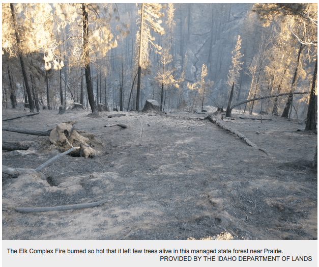
Emmett logger Tim Brown had just completed the White Flat timber sale on the Boise National Forest near Prairie when the Elk Complex Fire burned through in early August, destroying most of the remaining trees.

“That timber sale completely burned up,” said Dave Olson, a Boise National Forest spokesman.

The same happened on state lands nearby.

With extremely dry conditions and 50-mph winds, the fire burned so intensely that even the 6,000 acres of intensively managed state endowment forests burned, said Idaho Department of Lands Director Tom Schultz.

“There is little that land managers can do to prevent that kind of intense fire behavior,” said Schultz, who holds a master’s degree in forestry.

SO MUCH FOR RESTORATION TO HISTORICAL NORMS

Gil sent this in and suggested it as a new thread.. but I thought it was an interesting juxtaposition with this piece in the Denver Post on Park Service fire policy.

Otherwise, park officials prefer to herd fires where they want them to go and allow blazes to burn out on their own.

It’s a science-based approach that serves the same function as offseason forest thinning and controlled burns. But those arguments often fail to stand up to public distaste for trees burning in beloved national parks.

and..

As the Rim fire invades Yosemite, park officials pore over maps that reflect the historic fire return interval — the frequency that natural fire goes through an area. Every acre of the park is mapped in this fashion, and each has a fire “prescription.”

So, for instance, when the blaze hits an area of the park where fire returns every 12 years — but hasn’t been burned in 16 years — the prescription for that area is to let it burn.

“In the national parks, a major part of our job is to protect a place so that nature can work,” said Yellowstone spokesman Al Nash. “In many large parks in the West, fire is one way that nature works.”

I wonder if these folks are even aware that Nature is an idea and managing to a historic frequency is based on an idea and value, not “science.” These people are in dire need of Botkin and his book. IMHO.

So back to Gil’s post. Like I said, interesting juxtaposition.

SO MUCH FOR RESTORATION TO HISTORICAL NORMS <–

Click to access FS_Climate1114%20opt.pdf

– "By the end of the 21st century, forest ecosystems in the United States will differ from those of today as a result of changing climate. Although increases in temperature, changes in precipitation, higher atmospheric concentrations of carbon dioxide (CO2), and higher nitrogen (N) deposition may change ecosystem structure and function, the most rapidly visible and most
significant short-term effects on forest ecosystems will be caused by altered disturbance regimes. For example, wildfires, insect infestations, pulses of erosion and flooding, and drought-induced tree mortality are all expected to increase during the 21st century. These direct and indirect climate-change effects are likely to cause losses of ecosystem services in some areas, but may also improve and expand ecosystem services in others. Some areas may be particularly vulnerable because current infrastructure and resource production are based on past climate and steady-state conditions. "

– PNW – "Climate is projected to become unfavorable for Douglasfir (Pseudotsuga menziesii (Mirb.) Franco) over 32 percent of its current range in Washington, and up to 85 percent of the range of some pine species may be outside the current climatically suitable range." Bye, Bye NSO, Hello Barred Owl.

– NE – "A warmer climate will cause a major reduction of spruce-fir forest, moderate reduction of maple-birch-beech forest, and expansion of oak-dominated forest. Projections of change in suitable habitat indicate that, of the 84 most common species, 23 to 33 will lose suitable habitat under low- and high-emission scenarios, 48 to 50 will gain habitat, and 1 to 10 will experience no change."

Yosemite Wildfire Study

While browsing for historical fire maps, I ran across this interesting study of Yosemite wildfire issues. I scanned some of the study and felt it would be useful information.

http://staff.washington.edu/jlutz/Publications/Lutz_vanWagtendonk_Thode_Miller_Franklin_Climate_Fire_IJWF_2009.pdf

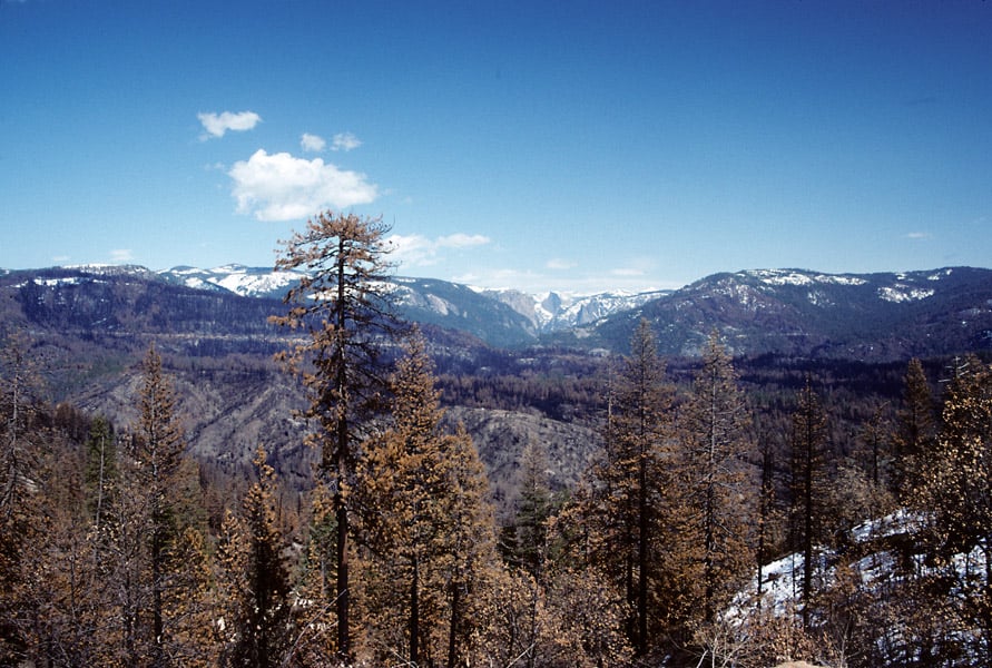
I didn’t know that there are fewer individual and less severe wildfires in the early season, due to snowpack’s effect on thunderstorm development. The Forest Service land, where I took this 1990 picture of the A-Rock Fire, has burned 13 times in the last 100 years. Why did this particular wildfire kill so much old growth, when previous uncontrolled fires did not?

A-Rock3-web

You can also see the fire’s “twin”, across the canyon. It also has suffered a re-burn, although it was the Park Service who let a fire get out of hand, on that incident too. The A-Rock re-burned when a prescribed fire was lit, and lost, within an hour of ignition. The Meadow Fire burned for weeks, costing $17 million, closing the Park during the height of tourist season. The Forest Service portion of the A-Rock Fire hasn’t re-burned, yet.

Renewable energy in the West on track to be cost-competitive with fossil fuels — without subsidies

Bob Berwyn had this post which I found interesting..being from Golden, it’s hard for me not to be optimistic about transitioning to a low carbon economy in the next couple of decades.

Here’s a link.

Energy is related to our usual business for a number of reasons; can occur on public land, climate change is ultimately related, and possibly that if this kind of development led to cheaper power than hydropower dams (I don’t know much about relative pricing) it seems like it might be a good thing for salmon. More important than keeping timber harvesting with appropriate BMPs from O&C lands, for example.

Below is an excerpt:

“Renewable energy development, to date, has mostly been in response to state mandates,” Hurlbut said. “What this study does is look at where the most cost-effective yet untapped resources are likely to be when the last of these mandates culminates in 2025, and what it might cost to connect them to the best-matched population centers.”

The study draws on an earlier analysis the lab conducted for the Western Governors’ Association to identify areas where renewable resources are the strongest, most consistent, and most concentrated, and where development would avoid protected areas and minimize the overall impact on wildlife habitat.

Other findings include:

Montana and Wyoming could emerge as attractive areas for wind developers competing to meet demand in the Pacific Northwest.
The challenge for Montana wind power appears to be the cost of transmission through the rugged forests that dominate the western part of the state.
Wyoming wind power could also be a low-cost option for customers in Utah, which also has its own diverse portfolio of in-state resources.
California, Arizona, and Nevada are likely to have surpluses of prime-quality solar resources. None is likely to have a strong comparative advantage over the others within the three-state market, unless environmental or other siting challenges limit in-state development. Consequently, development of utility-scale solar will probably continue to meet local needs rather than expand exports.
New geothermal development could trend toward Idaho by 2025 since much of Nevada’s resources have already been developed. Geothermal power from Idaho could be competitive in California as well as in the Pacific Northwest, but the quantity is relatively small. Reaching California, Oregon, and Washington may depend on access to unused capacity on existing transmission lines, or on being part of a multi-resource portfolio carried across new lines.

The study notes future electricity demand will be affected by several factors including: trends in the supply and price of natural gas; consumer preferences; technological breakthroughs; further improvements in energy efficiency; and future public policies and regulations. While most of these demand factors are difficult to predict, the study’s supply forecasts rely on empirical trends and the most recent assessments of resource quality.

USFS Fire Lab and Wuerthner: Wind Drives All Large Blazes

Below are excerpts from a couple of articles about the fact that wind and weather conditions drive all large wildfires.

From the Missoulian:

Larry Bradshaw was riding his motorcycle down U.S. Highway 12 on Monday afternoon when he noted the building smoke and stiffening winds.

It was an acute observation for a meteorologist who has worked at the U.S. Forest Service’s Fire Sciences Laboratory in Missoula since 1992, and still maintains the National Fire Danger Rating System.

Bradshaw tuned into the scanner a few hours later and listened as chaos unfolded ahead of the West Fork II fire, the blaze jumping the highway he’d ridden hours earlier before making a run east down the Lolo Creek Canyon.

“The winds were really strong out of the west,” said Bradshaw. “The inversion broke there earlier than it did in Missoula.”….

“It was the same recipe used on every fire – it’s dry and it’s windy,” said Finney. “We have a canyon situation and a couple fires low in the canyon. The fires have topography working in their favor – the canyon topography helping with the winds.”

The tools used by fire managers to predict the interaction of wind, topography, weather and fuel were developed here by the likes of Bradshaw and Finney and dozens of other scientists working up and down these hallways, part of the government’s Rocky Mountain Research Station….

“The thing we have to realize is that fires are inevitable. They’re impossible to completely exclude from the landscape,” Finney said.

“By trying to do that and doing it so successfully, what we’ve done is saved up the fires for the worst conditions. When you get rid of all the fires under moderate conditions, all you have left are the extreme ones.”

The other article is a column by George Wuerthner, which appear at The Wildlife News:

As large fires have spread across the West in recent decades, we hear increasing demands to reduce fuels—typically through logging. But logging won’t reduce the large fires we are experiencing because fuels do not drive large fires….

The ingredients found in all large blazes include low humidity, high temperatures, and drought. Assuming you have these factors, you can get an ignition if lightning strikes. But even an ignition won’t lead to large fires.

The final ingredient in all large blazes is wind.

Wind’s effect is not linear. In other words, increasing wind speed from 10 mph to 20 mph does not double fire spread, rather it leads to exponential fire growth and increases the burn intensity….

Most large fires have wind speeds of 30-50 mph or more. Wind makes fire fighting difficult since embers are blown miles ahead of the burning fire front. It is also the reason why wind makes fuel reduction projects ineffective.

Wind drives flames through and over fuel treatments. Even clearcuts with little or no fuel will not halt a wind driven fire. The wind driven fire just dances around and over any fuel breaks.

The biggest problem with fuel reductions is that one can’t predict where and when fires will occur. The likelihood of a wildfire will encounter a treated forest in the time scale when fuel reduction are effective is incredibly low.

The vast majority of acreage burning around the West are occurring in higher elevation forests like lodgepole pine and various fir species that naturally burn at infrequent intervals, often hundreds of years apart. As a consequence, a fuel treatment in such forests is a waste of time because the probability of a fire occurring at all in the time when fuel reductions are effectiveness is extremely low.

Even in drier forests like ponderosa pine that burn more frequently the chances that a fire will encounter a fuel treatment while it’s most effective is around 1-2%.

There is a role for fuel reduction projects. The best ones are targeted near communities and other areas of interest. The idea being one cannot predict where a fire may start, but one can predict what you don’t want to burn up in a fire. So focus fuels reductions adjacent to those places.

The most important fuel reduction projects should occur in the communities themselves. Removal of wood piles from adjacent to homes. Clearing pine needles from roofs. Getting rid of flammable building materials like cedar shake roofs.

Reducing the flammability of homes are the kinds of “fuel reductions” that work and should be encouraged. If these fuel reductions were implemented religiously, we wouldn’t have to worry about wildfires in the hinterlands, and we could permit these blazes to do the important ecological work they perform without continual interference from humans, yet feel secure in the knowledge that our communities were safe from wildfires.

Climate Change and Fire Management Implications

glyph

I realized that many readers might be interested in this research synthesis and not be following comments (I found this in response to a comment by John Persell) so here it is.

I think folks are pretty aware of current climate thinking and its impacts on fire. There is even a handy synthesis for managers here on the Wildland Fire and Climate Change part of the Climate Change Resource Center. Like many things about climate change, what you should do is generally sort of common-sensical to practitioners (although we might disagree about details and priorities)

When I worked in Climate Change in the Forest Service, I used to say if it’s not in CCRC, you probably don’t need to know.

Options for Management

In some western dry forests, particularly those affected by 20th-century fire exclusion, thinning and surface fuel treatment (including prescribed burning) can reduce fire severity and fire hazard [36], although maintenance treatments may be required every 20 to 40 years. Strategic placement of treatments can greatly increase the effective area treated [37]. In unmanaged forests, especially in areas in which fire suppression is difficult, expensive, or counterproductive to resource objectives, managers can take advantage of the self-limiting nature of wildfire. Fire spread rates and severity are reduced when a fire reaches a recently burned area [38].

Fuel treatments will be challenging to implement at spatial scales large enough to have much impact, especially if wildfire increases greatly in the future, but can enhance resilience on specific landscapes with high resource, economic, or political values (e.g., the wildland-urban interface). In the Southeast, undergrowth may grow even faster in warmer temperatures. Management practices may need to respond to an increase in available fuels, while anticipating a shortening of the prescribed burning “season”, particularly in Florida [39].

Some general guidelines for adaptation [40,41,42]

Increase landscape diversity — increase large-scale resilience, size of management units, and connectivity.
Maintain biological diversity — experiment with species and genotype mixes, and identify species, populations, and communities that are sensitive to increased fire and develop conservation plans for them.
Plan for post-disturbance management — treat fire and other ecological disturbances as normal processes and incorporate fire management into planning.
Maintain and improve the resilience of watersheds and aquatic ecosystems by implementing practices that protect, maintain, and restore watershed processes and services.
Implement early detection and rapid response — monitor post-fire conditions, and eliminate or control exotic species early on.
Manage for realistic outcomes — identify key thresholds and prioritize projects with a high probability of success; abandon hopeless causes; consider even alternatives that might be undesirable in an unchanging climate.
Incorporate climate change into restoration — avoid trying to replicate historical conditions, but continue to learn lessons from historical variation.
Develop regulations and policies that take climate change into account — raise awareness with stakeholders, and work with local stakeholders from the onset of projects.
Anticipate big surprises — expect mega droughts, larger fires, species extirpations, loss of resilience and system collapses, and incorporate these events in planning.

West Fork 2 Fire, Lolo National Forest

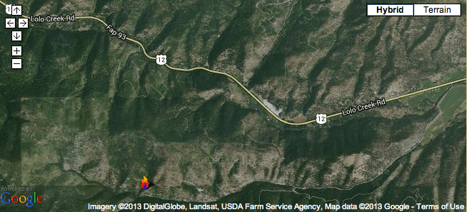
Official image from the federal government's InciWeb site showing the landscape burning as part of the West Fork 2 fire on the Lolo National Forest. The flame on the bottom portion of the image shows the general location of the start of the fire.
Official image from the federal government’s InciWeb site showing the landscape burning as part of the West Fork 2 fire on the Lolo National Forest. The flame on the bottom portion of the image shows the general location of the start of the fire.

Consider this post sort of a companion piece to Larry’s “American Fire, Tahoe National Forest” post below. The West Fork 2 wildfire started via a lightning strike early Sunday morning. Yesterday, was yet another 90+ day in Missoula (adding to the record total number of days over 90 this year). By mid-day humidity bottomed out at 16% and the winds gusted from the west at 40 mph.

As a result the West Fork 2 fire – burning through a heavily fragmented, clearcut, logged, roaded, weeded landscape just west of Lolo, Montana – ripped pretty good, burning some houses and dumping smoke, ash and charred bark into the Missoula Valley.

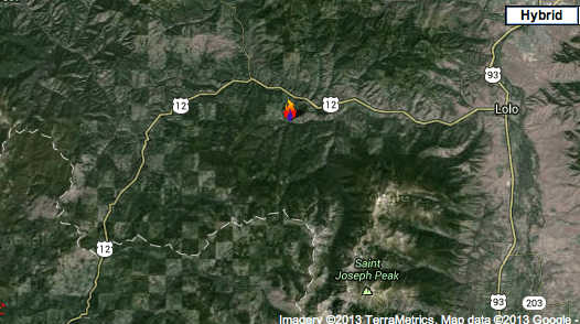
Here’s another image of the general location of the fire from a wider angle, showing more of the heavily fragmented landscape.

WestFork2_Wide Pan

P.S. And thank goodness the Tar Sands megaloads came through – and blocked all traffic – on US Highway 12 a few days ago…and not during the course of this wildfire incident. One has to wonder how the evacuation of homes, people, pets and belongings and the response of firefighters, sheriffs and emergency personal would have been impacted a few days earlier with the Tar Sands megaloads blocking the highway.