Social Science around Communities and Fire Adaptation: I. The Museum Fire and Aftermath

A view of a steep slope burned by the Museum Fire. Photo courtesy of Melanie Colavito, Ecological Restoration Institute
Every fire season it seems like news stories tend to quote a variety of scientists, including climate scientists, but not so much social scientists. Which in a way is odd, because the journalists always ask them questions like “what should be done?” and “what are the barriers?” which social scientists have studied across the West for decades (at least). I’m going to highlight some of these over time, and hopefully we at least will then be familiar with some of their work by next fire season. We can observe the nature and culture of communities that the studies examine; their location and physical/biological/ecological context; their proximity to universities and other scientific institutions, and other elements of interest that may influence the scientists’ findings. TSW and other folks are encouraged to send me links to such studies.

First I’ll start with this post on Catrina Edgeley and Melanie Colavito’s work in Flagstaff. This article was originally posted on the Fire Adapted Communities Learning Network Blog and is reproduced here with their permission. They are social scientists with the NAU Ecological Restoration Institute. I first heard about this work via a presentation Catrina gave at the SAF Convention last fall. I appreciate how they condensed their work for accessibility. The Museum fire was started by contractors’ equipment working on a fuels reduction project, so the scientists studied how that influenced peoples’ ideas about fuel treatments.

How can we harness public support for restoration and wildfire risk reduction?

Based on our survey data, high public support for active forest management seems likely to continue. How can we capitalize on this “window of opportunity” moving forward?

*Incorporate and continue community-approved approaches. Familiarity with the rationale and need for existing management activities like FWPP have built confidence in collaborative approaches. That is no small feat and took several decades to achieve in the Flagstaff area. However, now that it has become ingrained in community culture, the community is more socially resilient to fire events when they do occur. Acknowledging local support for, and continuing to invest in, collaborative approaches will be key to maintaining momentum for forest management in Flagstaff.

Collaborative community-based approaches and building trust is significant.

*Demonstrate what you’ve learned from past fires (and how you’ve implemented those lessons) to build trust. The last page of our survey allowed respondents to provide additional comments they thought might be relevant to our study. Many long-term Flagstaff residents commented that once the Museum Fire began, they clearly saw lessons learned implemented from the Schultz Fire. While newcomers and more skeptical respondents asked how professionals would use takeaways from the Museum Fire moving forward. Transparency about how a fire event advances local wildfire response within agencies and governments is key to building confidence and opening an inclusive conversation about local fire adaptation. Successful efforts to create transparency in Flagstaff have included Coconino County and Forest Service employees speaking directly with the public about changes to decision-making processes, mailing fact sheets that document updates and changes on public land to adjacent private property and acknowledging agency and organizational limitations before, during and after fire. Highlighting specific partnerships that have emerged after fire was often well-received and celebrated by members of the public in Flagstaff.

The California Wildfire and Forest Resilience Action Plan of 2021- Forest Service Contributions

Are we headed for an abstraction knock-down with the 2012 Planning Rule requiring managing National Forests for “ecological integrity” and states like California promoting “resilience”? I bolded the FS goals below. Note that with regard to PB, CALFIRE, among other things,  will “increase support for workforce development and training programs, and evaluate options to address liability issues for private landowners seeking to conduct prescribed burns for the private insurance market.” I just posted the summary below, so there may be other FS contributions in the main document.

****************************************

In January the State of California came out with:

The Wildfire and Forest Resilience Action Plan is designed to strategically accelerate efforts to:
» Restore the health and resilience of California forests, grasslands and natural places;
» Improve the fire safety of our communities; and
» Sustain the economic vitality of rural forested areas.

To meet these goals, the following will need to be achieved:
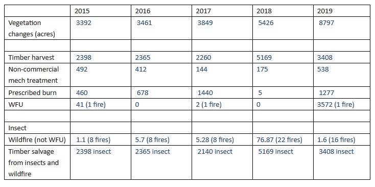
Scale-up forest management to meet the state and federal 1 million-acre annual restoration target by 2025.
» The Department of Forestry and Fire Protection (CAL FIRE) and other state entities will expand its fuels management crews, grant programs, and partnerships to scale up fuel treatments to 500,000 acres annually by 2025;
» California state agencies will lead by example by expanding forest management on state-owned lands to improve resilience against wildfires and other impacts of climate change; and
» The USFS will double its current forest treatment levels from 250,000 acres to 500,000 acres annually by 2025.

Significantly expand the use of prescribed fire across the state:
» CAL FIRE will expand its fuels reduction and prescribed fire programs to treat up to 100,000 acres by 2025, and the California Department of Parks and Recreation (State Parks) and other state agencies will also increase the use of prescribed fire on high-risk state lands;
» The USFS, in partnership with CAL FIRE, tribal governments, and other agencies will seek to establish a Prescribed Fire Training Center to provide training opportunities for prescribed burn practitioners and focus training efforts on western ecosystems;
» CAL FIRE will also establish a new tribal grants program, increase support for workforce development and training programs, and evaluate options to address liability issues for private landowners seeking to conduct prescribed burns.” for the private insurance market;
» The USFS will significantly expand its prescribed fire program to attain its 500,000-acre target for forest treatments by 2025.

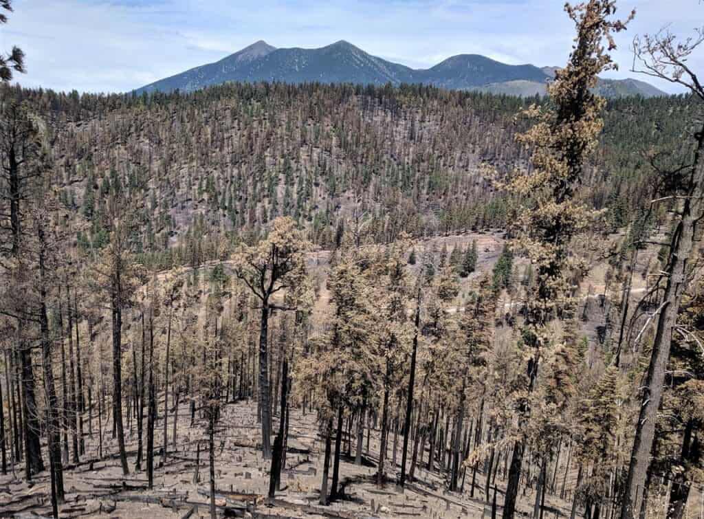
Reforest areas burned by catastrophic fire:
» The USFS will develop a restoration strategy for wildfire impacted federal lands and CAL FIRE will partner with the California Office 6 January 2021 of Emergency Services (Cal OES) and other federal, state, and local agencies to develop a coordinated strategy to prioritize and rehabilitate burned areas and affected communities. These ecologically-based strategies will focus on silvicultural practices that increase carbon storage, protect biodiversity, and build climate resilience.

Support communities, neighborhoods, and residents in increasing their resilience to wildfire:
» CAL FIRE will significantly expand its defensible space and home hardening programs and launch a new program building upon the Governor’s 35 Emergency Fuel Break Projects by developing a list of 500 high priority fuel breaks across the state. This list will be continuously updated.                                    
» The California Natural Resources Agency (CNRA) will expand its Regional Forest and Fire Capacity (RFFC) Program to all high-risk areas throughout the state and increase local and regional governments’ capacity to build and maintain a pipeline of forest health and fire prevention projects.

Develop a comprehensive program to assist private forest landowners, who own more than 40 percent of the state’s forested lands:
» CAL FIRE will coordinate the implementation of several grants and technical assistance programs for private landowners through a unified Wildfire Resilience and Forestry Assistance Program.

Create economic opportunities for the use of forest materials that store carbon, reduce emissions, and contribute to sustainable local economies.
» The Governor’s Office of Planning and Research (OPR) is leading the development of a comprehensive framework to expand the wood products market in California and will partner with CAL FIRE, the Governor’s Office of Business and Economic Development (GoBiz), the USFS, and the California Infrastructure and Economic Development Bank (iBank) to draft a market development roadmap and catalyze private investment into this sector.

Improve and align forest management regulations:
» The Board of Forestry and Fire Protection (BOF) is leading the expansion of a new online permitting tool and permit synchronization initiative to provide a one-stop shop for permits from several agencies and will use the California Vegetation Treatment Program (CalVTP) to streamline project planning and environmental review.

Spur innovation and better measure progress:
» CAL FIRE and the USFS, in coordination with the USDA California Climate Hub, the California Air Resources Board (CARB), and other agencies, will seek to establish a Forest Data Hub to coordinate and integrate federal, state, and local reporting on forest management and carbon accounting programs, and serve as a clearinghouse for new and emerging technologies and data platforms.
This strategy will also be integrated into the state’s efforts to combat climate change through the following actions:
1.   Scale-up forest thinning and prescribed fire efforts to reduce long-term greenhouse gas emissions and harmful air pollution from large and catastrophic wildfires;
2.  Integrate science-based climate adaptation and resiliency strategies into the emerging state-wide network of regional forest and community fire resilience plans;
3. Drive forest management, conservation, reforestation and wood utilization strategies that stabilize and increase the carbon stored in forests while preserving biodiversity and revitalizing rural communities;
4. Improve electricity grid resilience; and
5. Promote sustainable land use.

The Path to Healthy Headwater Forests: PPIC Webinar Tomorrow!

The webinar is from 11-12 Pacific and features a presentation of their (PPIC is the Public Policy Institute of California) research paper, a panel discussion, and questions and answers. Here’s the link to the webinar information and registration. The study (found here) has some interesting charts and graphs. I picked a few to highlight below. There’s an interesting interactive map, but I couldn’t copy it here.

Here are their findings:

Last summer, California and the US Forest Service (USFS) jointly agreed to significantly increase two important management approaches—mechanical thinning and prescribed fire—over the next five years. In January, the Forest Management Task Force released California’s first action plan for forest health. State funding for improving forest health has increased since 2019, and the governor’s 2021‒22 budget proposes to continue this trend.

As policymakers and forest managers take steps to accelerate the pace, understanding the scale and scope of recent management efforts can provide useful guidance. Yet until now there hasn’t been a comprehensive picture of how private, state, and federal entities have managed forests. To fill this gap, we did a basic accounting of management efforts in mixed-conifer forests in the Sierra‒Cascade region over the past decade.

Here are four takeaways:

*Forest management is not scaling fast enough to meet forest health objectives. Experts suggest that reducing the spread of severe wildfires requires strategically treating and maintaining approximately 20‒30% of forests on the landscape. Forest managers have treated around 16% of the region’s mixed-conifer forests over the past decade. Management levels vary across the region, with only 8 of the 24 watersheds meeting or exceeding this target (Figure 1c). The pace has been considerably faster on lands owned by the private sector and non-federal agencies (28%) than on federally owned lands (11%).

*Timber harvest has been the main management approach. Though its primary purpose is to harvest logs, some timber harvest techniques also reduce wildfire risk and improve resilience to drought and pests. More than two-thirds of the 912,000 acres managed over the past decade used timber harvesting (Figure 2). The practice was more prevalent in northern watersheds, where private forest ownership is more common. The costs and benefits of different management approaches—timber harvest, mechanical thinning, and prescribed burning—should be at the center of discussions about which to use where.

*Management approaches vary based on ownership. Nearly 90% of acres managed on private forests were harvested (Figure 3). By contrast, federal forests had a more diversified management portfolio, and timber harvest accounts for less than half of managed acres on these lands. In absolute terms, USFS carried out three times more mechanical and prescribed burning treatments compared to private and other public landowners in the region.

*The pace of management has been flat. Although the share of non-timber management has increased, the overall pace of management has remained relatively stable over the past decade—at around 90,000 acres annually (Figure 4). One likely explanation: public funding sources that support management have also been stagnant over this period. The pace should pick up once new state funds for forests reach the ground.

As forest managers and policymakers chart a course to improve forest health, improving our overall understanding of past management activities is essential. Our analysis helps provide a clearer picture of forest management accomplishments and gaps—which can in turn help set priorities for allocating scarce management resources. Yet the technical challenge of even basic accounting of these activities remains immense. Data sets that make accounting possible have different levels of quality and collection standards. Improving the accuracy, completeness, and comparability of data collected on forest management across the headwater region will be critical for evaluating progress toward meeting goals for forest health.

It’s kind of interesting to me that the data we need doesn’t seem to exist, and yet… so much funding seems to be going to various satellite imaging efforts. Maybe it’s time for the western FIA’s to start a Fire-Related Forest Vegetation data effort.. they already have the history of working with stakeholders, States and Tribes and dealing with privacy issues. A bipartisan unity-building effort? After all, everyone likes good data!

Fuels reduction projects limited damage from Creek Fire: Post from Wildfire Today

Thanks to Bill Gabbert and Wildfire Today for this post to a video about fuel treatments and the Creek Fire.

Part of the post is a video produced by the Alaska Interagency Incident Management Team featuring folks from the Forest Service and Calfire about how their work…worked.  For those of us who have worked in the Sierra, it may be interesting to see what the stands looked like after mechanical treatments and prescribed burns, and what they looked like after the fire came through.


We’ve Been Adapting to Climate in These Places for 10,000 Years: Learning from Ancient WUI Practices in New Mexico

Conceptual map of landscape zones and 27 fire and wood uses for Hemish people.

At a webinar I attended yesterday, one of the speakers worked for Indian Country Today.   He spoke a bit about climate and pointed out that Native people have been adapting to changing climate for 10,000 years. Recently in the scientific literature, we’ve heard much more about traditional burning practices, and what we can learn from Native American practices. Perhaps the selection of Deb Haaland as Interior Secretary could accelerate this trend, especially with scientific research as USGS is in Interior.

Thanks to Rebecca Watson  for the link to this interesting (open-source, yay!) study  by Roos et al.

Policy Implications.

The Jemez ancient WUI obviously contrasts with modern WUI in the American West in ways that make the ancient WUI an imperfect analog for modern conditions. The economic, technological, and political differences are irreconcilable but they do not obviate the relevance of the ancient WUI for modern problems. The cultural contrasts between ancient and modern WUI highlight opportunities to cultivate more resilient communities by supporting particular cultural values. Two of the important characteristics of the Jemez ancient WUI are: 1) That it was a working landscape, in which properties of the fire regime were shaped by wood, land, and fire use that supported the livelihoods of the residents; and 2) that there was much greater acceptance of the positive benefits of fire and smoke. We emphasize that these are malleable cultural features, because reshaping western United States culture by learning from indigenous cultural values may be critical for building adaptive and transformative resilience in modern communities (26288586). Learning to value the positive benefits of fire and smoke and to tolerate their presence will undoubtedly be critical to WUI fire adaptations. Furthermore, the ancient WUI highlights two key processes that may make modern WUI more resistant to extreme fires: 1) Intensive wood collecting and thinning, particularly in close proximity to settlements; and 2) using many small, patchy fires annually (approximately 100 ha) rather than using larger burn patches (thousands of hectares) to restore fire and reduce fuel hazards, particularly closer to settlements. Many WUI communities—especially rural and Indigenous communities—rely on domestic biomass burning for heat during the winter. Public/private–tribal partnerships to thin small diameter trees and collect downed and dead fuel for domestic use could have dual benefits for the community by meeting energy needs and reducing fuel loads. Tribal communities that have deep histories in a particular forested landscape may be ideal partners for supervising such a program (87). Lessons from the Jemez ancient WUI also suggest that federal and state programs to support prescribed burning by Native American tribes, WUI municipalities, and private land owners would provide equal benefit to modern communities (88). It is imperative that we understand the properties and dynamics of past human–natural systems that offer lessons for contemporary communities (8991). The Jemez ancient WUI is one of many such settings (729297) where centuries of sustainable human–fire interaction offer tangible lessons for adapting to wildfire for contemporary communities.


Vegetation Change and Vegetation Management: A Potential New National Forest Report Format

I remember Chris Iverson, noted expert in wildlife and forest planning, saying something once about forest plans like “if you don’t do much, you shouldn’t spend as much time planning.” As I recall, he was talking about the Chugach compared to the Tongass forest plans. But what exactly is “doing much”? What seems to be most controversial and widespread is vegetation management for forest management.

I thought it would be interesting to see where the Rio Grande (with a recent plan revision) fell on that scale, and many thanks to them for their help in collecting this information. I think it would be great to have this information available for all forests. First, the total acres of the Rio Grande is 1.83 million acres to give context. You could easily do this table with percentages and be able to compare the acres impacted by management across different National Forests, as well as vegetation changes due to human and other factors.

What we got from the Forest was total acres of all vegetation treatments, not duplicating the same acres with different treatments (double counting).

According to the forest, the average timber harvest has been around 3100 acres per year. All of that has been insect salvage except for 120 acres in 2017. So that’s about 2% of the forest per year. Of course, salvaging spruce beetle trees that are dead may have different impacts than green sales, but this table is about all acres impacted by vegetation management and other vegetation change.

After collecting this information, I realized that a 10 year timespan may have been better. In 2013, the West Fork Complex Fire burned 87,662 acres of the Rio Grande. Then there’s the spruce beetle outbreak itself over time, accumulating to 617,000 acres. I didn’t fill in that row in the table, but the information is available from the aerial survey folks.

It would be interesting to see at least 10 years with the acreage by type plotted over time, including large events like bug and fire acres, for each National Forest. I think it would be very informative to compare forests, both in total acres of different kinds of human and other vegetation changes, and percentages of the total acres impacted.

I’m not saying that this is the perfect formulation for people to get a grasp of “relative vegetation management” I’m just asking “doesn’t this way of looking at it tell us something of value”?

What would you add or change?

Also circling back to the forest planning question, if some forests, say in R5, have had up to 80 % of their forest affected by wildfires over the past 5 to 10 years, should everyone else stop planning so that they can go into revision? And if “fires are going to get larger due to some combination of fire suppression, increased ignitions and climate change” should then the amount of vegetation modeling done during plan revision be scaled back for fire-prone Forests as not a great investment? Perhaps less energy on modeling and more energy on responding to fire and other changes via amendment?

Study: Wildfires produced up to half of pollution in US West

Hayman Fire 2002 from Colorado Springs. Wildfire smoke isn’t new, but measuring it has definitely ramped up in the last 20 years.

I like how this the author of this AP story sought out different scientific points of view. Thanks for sending, Rebecca!

Some scientists say: Wildfires are all about climate change, study in PNAS:

The findings underscore the growing public health threat posed by climate change as it contributes to catastrophic wildfires such as those that charred huge areas of California and the Pacific Northwest in 2020. Nationwide, wildfires were the source of up to 25% of small particle pollution in some years, the researchers said.

“From a climate perspective, wildfires should be the first things on our minds for many of us in the U.S.,” said Marshall Burke, an associate professor of earth system science at Stanford and lead author of the study.

“Most people do not see sea-level rise. Most people do not ever see hurricanes. Many, many people will see wildfire smoke from climate change,” Burke added. The study was published in the Proceedings of the National Academy of Sciences.

Other scientists say: Wildfires are not ALL about climate change, and why pick 10 years if you have satellite data?

There’s little doubt air quality regulations helped decrease other sources of pollution even as wildfire smoke increased, said Loretta Mickley, an atmospheric chemist at Harvard University. But it’s difficult to separate how much of the increase in smoke pollution is driven by climate change versus the forest fuel buildup, she added.

Mickley and researchers from Colorado State University also cautioned that fires can vary significantly from year to year because of weather changes, making it hard to identify trends over relatively short periods such as the decade examined in the new study.

Yet other scientists say:

The new study matches up with previous research documenting the increasing proportion of pollution that comes from wildfire smoke, said Dan Jaffe, a wildfire pollution expert at the University of Washington. Jaffe added that it also raises significant questions about how to better manage forests and the role that prescribed burns might play.

“We have been making tremendous progress on improving pollution in this country, but at the same time we have this other part of the puzzle that has not been under control,” Jaffe said. “We’re now at the point where we have to think about how to manage the planet a whole lot more carefully than we’ve done.”

While looking at some historic documents about air quality, I ran across this:

On 28 July 1994, dry-lightning storms started multiple wildfires across the Eastern Cascades of central Washington State. Conditions were extremely dry in the national forests. The 1994 water year was the third in a row in which annual streamflow had been well below average at various long-term gaging stations (USGS 2004; Robison 2004). Water years 1993 and 1994 were more than one standard deviation below period of record average values for the Wenatchee, Stehekin and Methow Rivers. The largest of the fires burned 185,000 acres (74,867 ha) on the Wenatchee National Forest. At that time, it was the largest wildfire complex within a single national forest in the history of the Forest Service (FS). The fires caused many weeks of impaired air quality in all five cities of Chelan County. This paper discusses the evolution of two resource management programs, the Healthy Forests Initiative, relying heavily on prescribed fire, and the Air Quality Management Program, both of which have evolved since the fires of 1994. The subject area is the Okanogan-Wenatchee National Forests (Forests) of central Washington State (Figure 1).

Folks have obviously been trying to ramp up prescribed fire since the mid-90’s- even before climate change developed as the umbrella issue.

Will framing it as a climate issue instead (as promoted by some scientists) help or hurt these efforts that have struggled for at least thirty years to get attention and support? Not to pick on Jaffe but the quote says “we have to think about how to manage the planet a whole lot more carefully than we’ve done.” I think there’s been quite a bit of thinking, since Biswell in the 40’s. The problem to me is about actually doing something that’s been adequately thought out, but has a host of well-documented difficulties in implementation. Will the energy of defining it as a climate issue bring it more attention and push us over the hill of difficulty? Or just more words and studies?

North Versus Hanson

Experts Frustrated by Stalled Efforts to Counter Megafires

“Use every damn tool you’ve got,” he said. “If we could have beavers on crack out there I’d be donating to that process — anything that will speed up the pace and scale of this thing.”

Dr. Malcolm North

Linn County Files Lawsuit To Obtain Documents on Beachie Creek Fire

Beachie Creek Fire progression map

In one of my jobs with the Forest Service, I had the FOIA people working on my staff.  Through these folks, I gained some understanding, and experienced a some small amount of what it is to work in FOIA.  It’s a strange job in that you have a widely varying workload (with no upper bound) and required deadlines, but only so many knowledgeable people available to work. And it tends not to be glamorous or highly valued, with sometimes disrespectful folks in the public to work with. So here’s a shout out to them!

This story from Wildfire Today also reminded me of the gap between “doing” jobs (in this case, time was a factor) and “critiquing” jobs (at anyone’s leisure).  We need to introduce more fire into the landscape; but if people in hindsight are seen (in a courtroom) to have made “mistakes” in doing it.. well then. People are less willing to take chances, and so the idea of restoring fire to the landscape possibly becomes impossible.

A county in Oregon has filed a lawsuit against the U.S. Forest Service that is related to the Beachie Creek Fire that burned over 193,000 acres east of Salem, Oregon in September.

The Davis Wright Tremain law firm in Portland submitted a request September 28 on behalf of Linn county, requesting records related to the fire. The request cited the Freedom of Information Act (FOIA) which requires a federal agency to respond within 20 business days, unless there are “unusual circumstances,” or notify the party of at least the agency’s determination of which of the requested records it will release, which it will withhold.

About 12 percent of the Fire was in Linn County, with the rest in Marion and Clackamas Counties. The Linn-Marion county line is near Highway 22 close to the communities of Lyons, Mill City, Gates, Detroit, and Idanha where many structures were destroyed.

The Forest Service replied to the FOIA in a letter dated the next day, saying (and this is an exact quote):
“Please be advised your request is not perfected at this time and we will be reaching out to you to discuss clarification once it has been to thoroughly review.”
After not receiving the documents or apparently hearing nothing further from the Forest Service, the attorneys for Linn County filed a lawsuit November 2, 2020 in the U.S. District Court in Eugene, Oregon.

Here’s (some of) what the FOIA asked for:

The information Linn County requested from the Forest Service was about the agency’s policy for managing fires, and the Beachie Creek Fire in particular. Some examples:

Contracts and documents relating to arrangements made with outside contractors for firefighting equipment and training in the Pacific Northwest;
Maps and records depicting all former “owl circles” and all locations of other endangered species habitat in the 2 years immediately preceding the Beachie Creek Fire;
Records declaring the Beachie Creek Fire a Prescribed natural Fire, a Management Ignited Fire or a Wildfire, and all records discussing or relating to that declaration;
Records illustrating the Suppression Response for the Beachie Creek Fire;
Records illustrating the Control Strategy for the Beachie Creek Fire;
Records relating to inputs to and outputs derived from the FLAME computer program or any other predictive computer analysis for the Beachie Creek fire for the period commencing on August 1, 2020, through the date records responsive to this request are provided;
All Social media posts discussing or describing the Beachie Creek Fire;
All current Forest Service Manuals in effect immediately preceding the Beachie Creek Fire and effective throughout the Fire Event.

Here’s Bill Gabbert’s take:

The Forest Service is notorious for flagrantly violating the law in regards to the mandatory standards for providing information requested with a FOIA. They have been known to stall for years, or have simply refused to comply. Not every citizen seeking information from their government has a petty cash account with $400 for the filing fee, or the tens of thousands of dollars it could take to pay attorneys for a FOIA lawsuit. Our citizens deserve transparency. However, it also seems unusual to file a lawsuit approximately 26 business days, as Linn County did, after initially submitting the FOIA — just 6 days over the 20-day requirement.

(I’m not sure what the $400 would be for.)

The comments and references to other fires are also interesting. Especially related to size of fires, and changes in suppression strategies over time.

Hundreds of Giant Sequoias Considered Dead From Wildfires

It appears that rumors of ‘natural and beneficial’ wildfires in the southern Sierra Nevada have been ‘greatly exaggerated’. Even the Alder Creek grove, which was recently bought by Save the Redwoods, was decimated. Of course, this eventuality has been long-predicted.

https://www.latimes.com/environment/story/2020-11-16/sierra-nevada-giant-sequoias-killed-castle-fire