NOAA Smoke Map Link

This says it’s for today, but not sure it is.

Smoke maps can be handy for planning outdoor activities.

I’d always appreciated getting smoke maps from Bill Gabbert on Wildfire Today. Here’s how to get one for current and past days. If you don’t see the smoke colors, just go to the three lines on the left and make smoke toggle on. For some reason, I get the smoke overlay on some devices/days and not others, so if you don’t see it don’t give up.

Wilder Than Wild Documentary: Let’s All View and Discuss!

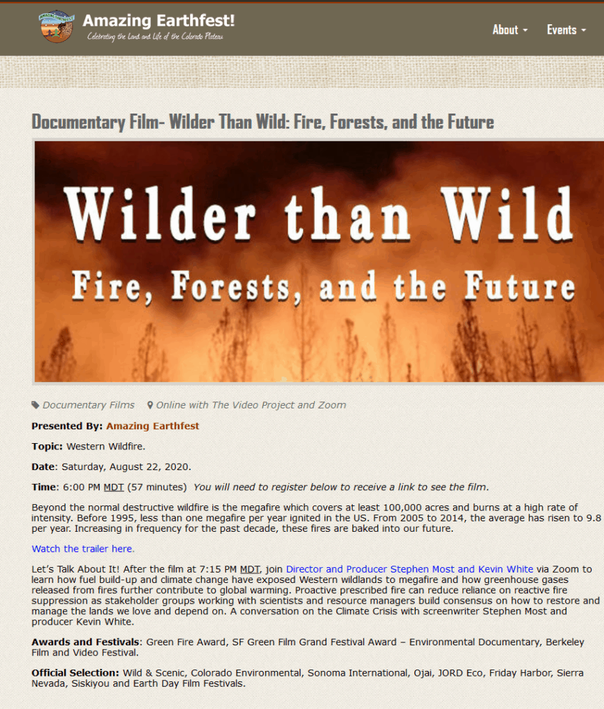
Matthew posted this by Doug Bevington about a documentary that elicited some discussion, but since it was shown by different stations across the US at different times, it was hard for us to see it together and discuss.

Stephen Most told me that Amazing Earthfest has a discussion of it on their schedule of events for August 22 at 6pm MDT. You can see Wilder than Wild online for free plus a Q & A with Stephen Most and the director, Kevin White, after it streams. You just need to register here, at the Amazing Earthfest site. Once you’ve registered, they provide a link so that you can view the film.

I watched the film and then re-read Bevington’s post, which, as you may recall started with:

Unfortunately, the filmmakers have chosen to make glaring omissions—excluding key scientific and environmental voices and leaving out essential facts—that cause their film to distort these issues more than it informs. As a result, the film gives cover to policies that are harmful to forests, dangerous for public safety, and detrimental to the climate, while steering attention away from genuine solutions.

I suppose it goes without saying that I did not see it that way.

What the film said to me is that:

1. Wildfires can do bad things to people, wildlife and their habitat, and watersheds.
2. Climate change will make things worse.
3. To protect things humans value, plus places where other creatures can live, we need to use PB and WFU.
4. Native Americans managed land using burning, and so PB has been used for thousands of years before Native Americans were killed off and displaced.
5. Given changed conditions, vis a vis people and climate change, we need to work together to figure out what is best for our mutual futures.

I don’t know how anyone can argue with these, but am willing to have the discussion in the comments.

The film also calls into question some of the proposed solutions:

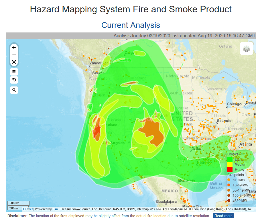
6. Some have said that the solution is for people to move somewhere else -out of the WUI- but you just can’t move entire towns and cities away. Plus the population is growing, and major cities have housing costs that are so high, people move farther away for affordability. There’s no way to force people to pay high rents for tiny places. The film says that there are 50 million folks currently living in the WUI.

7. Some have said something along the lines of “if you just protect 100 feet around your home, everything would be fine.” But the film shows a variety of infrastructure other than structures that are burned. Is a solution to make communities more fire-resilient? Yes. Is a solution also to keep fires out of cities and towns? Also yes. Is this controversial or wrong?

Finally, I thought it was interesting that people used the concept of “ecosystems evolving with fire”- but if Native Americans are thought to have been in California for 19000 years then the ecosystems evolved with Native Americans’ use of fire. We also know the climate has been changing for that time period, such that then we can’t really go back to a pre-Native American time (if we wanted to pick a human-free time). It seems that we’d have to say “the Native Americans got it right and that’s where we need to go even though the climate has changed since they were killed off” or “everything’s changed, given our values for species and people’s needs, we’re going to have to muddle through together.”

My own observations:

* Great videography of the fires and post-fire from above.

* There’re photos that show an old growth forest before and after an intense fire that certainly gives you the impression that at least some fires are not good for old growth and old-growth dependent species.

* Note that Calfire and the Park Service have prominent role in the film- hard to fit in the framing that it’s all about the FS wanting to log.

* The film shows the personal impacts of having a fire run through your community. In the El Paso County (Colorado) offices, we used to have an art exhibit created by people impacted by the Waldo Canyon Fire. These stories of personal impacts of wildfire I think are important to hear. Because (at least here) we do all need to work together, to keep fire out of communities, to evacuate, to house the people and animals, to tolerate PB smoke, and so on.

Quibbles:

If the quote about FS vs. NPS policies seemed not what you remember from the past… here’s an article by NPS that goes into more detail.

One thing that seemed to fit that wasn’t mentioned was the liability problem with PB. But this documentary was about California, and perhaps that is not a problem there.

Your thoughts?

Touchless reforestation

Drone technology is being used for tree-planting in response to afforestation and carbon sequestration needs, including use after wildfires. How might this change national forest management?

To quickly plant around a trillion trees—a goal that some researchers have estimated could store more than 200 gigatons of carbon—Flash Forest argues that new technology is needed. In North America, trees need to grow 10-20 years before they efficiently store carbon, so to address climate change by midcentury, trees need to begin growing as quickly as possible now. “I think that drones are absolutely necessary to hit the kind of targets that we’re saying are necessary to achieve some of our carbon sequestration goals as a global society,” she says.

But to restore forests that have already been lost, the drones can work more quickly and cheaply than humans planting with shovels. Flash Forest’s tech can currently plant 10,000 to 20,000 seed pods a day; as the technology advances, a pair of pilots will be able to plant 100,000 trees in a day (by hand, someone might typically be able to plant around 1,500 trees in a day, Ahlstrom says.) The company aims to bring the cost down to 50 cents per tree, or around a fourth of the cost of some other tree restoration efforts.

This has obvious implications for tree-planting crews, but how about something like salvage logging?  Other issues?

Webinar Tomorrow: Managing Fire for Water: Lessons Learned from Watershed Protection Partnerships for Wildfire Risk Reduction

May 27, 2020 10:00 am – 11:00 am PDT

FREE
Register

Among the values at risk from wildfire are community drinking water supplies, as forested watersheds on public land are often a primary or significant source of drinking water. In some places across the West, watershed protection partnerships have formed to address this threat by bringing together the stakeholders of these watersheds for collaborative planning and investment in source water protection. This webinar will explore the concept of watershed protection partnerships and how they span organizational boundaries for collective action to address wildfire and other risks. We will offer lessons learned from how these partnerships have been implemented in Colorado and New Mexico, and direct implications and applications for communities in Oregon.

Fire History and Human History in the Sierra Nevada: Taylor et al. 2016

Figure 2 from Taylor et al., 2016: “Regime shifts in time series (1600-2015 CE) of Sierra Nevada fire index, summer moisture (i.e., PDSI), and summer temperature (i.e., WANT). A switch to new regime (fire or climate) is shown by a vertical line … The number of tree-ring sites recording fires in each year for the 1600-1907 CE period shown by a dashed line. The fire regime periods are indicated by color shading: 1600-1775 CE (green), 1776-1865 CE (orange), 1866-1903 CE (blue), and 1904 CE to present (pink).”

This is the second of the two papers on how past human activities have affected current conditions. This is relevant to our understanding of what we see today, as well as any reference points for Historic or Natural ranges of variation. What I really liked about this 2016 paper is that it tackled the history of the Sierra Nevada specifically related to fire.

I first found the description of the study in this post by Leny Quinn-Davidson of the Fire Adapted Communities Learning Network.  Here is a link to the original paper, which is also worth reading, especially for those who don’t know much California history and/or find it interesting. The excerpts below are all from the Quinn-Davidson post.

The authors identified four major fire regime periods since 1600, which they were able to link to patterns of human activity. The first regime shift occurred in 1776, triggering a 90-year period of enhanced fire activity. During that period, the mean fire index was almost twice what it had been before 1775. The paper shows that this regime shift was coincident with the timing of Native American contact with Spanish missionaries in the region, which occurred in 1769. It’s not exactly intuitive, but the authors explain that the decimation of Native Americans—and a subsequent reduction in light burning—allowed for an increase in fuel continuity and wildfire activity during that period. This connection is further evidenced by the increased sensitivity of fire activity to climate—a relationship that was relatively weak when Native Americans were conducting widespread burning.

The second regime shift occurred in 1866, at which point fire activity dropped back to pre-1776 levels. The authors attribute this shift to major land use changes across the region—mostly associated with intensive livestock grazing, which denuded herbaceous vegetation and had notable effects on fuel continuity and fire spread. During this period, fire activity was also less sensitive to climate than it had been during the previous period because of a lack of fuels.

The third shift is the one we’re all most familiar with: the beginning of the fire suppression era in the early 1900s. During the fire suppression period, in which we’re still operating today, fire activity has been 4–8 times less than in any other period in recent history. Likewise, the fire-climate relationship has been weak for most of this period; the 20th century has shown increased warming trends, yet fire activity has largely been squelched by human activity. Only in recent decades have we seen a strengthening of that relationship, as a perfect storm of high fuel accumulations, longer fire seasons and drier conditions enables fires of unprecedented severity and size, appearing to override the moderating effects of human management.

But the really valuable thing about this new paper by Taylor et al. is that it gives us a larger context to work within. Yes, recent decades have had increased fire activity and increased sensitivity to climate—we’ve all seen it. But let’s remember that our collective frame of reference is relatively short; for most of us, our vision of what’s natural or normal in terms of fire comes from the mid to late 20th century—the height of our fire disconnect. This paper allows us to look back and see that the human relationship to fire is enduring and powerful, and that our biggest mistake in the last century has been to deny ourselves that intimacy—to value “nature” over nurture. History tells us that we should be able to buffer climate effects, but only if we actively engage at a grand scale. I think we’re ready.

Virus driving forest fire policy

It looks like the pandemic is taking the Forest Service back to the old days of fire suppression, when the goal was to have them all out by 10:00 am.  It will be interesting to see (if it’s possible) what actual difference that makes in the coming fire season (which is predicted to generally be normal or slightly worse).  Of course changes in operations from social-distancing may also be a factor.  And this all has be squared with the Chief’s pronouncement (quoted there):  “Forest Service resources will be used “only when there is a reasonable expectation of success in protecting life and critical property and infrastructure.”

Prior to this year’s COVID-19 complications, the U.S. Forest Service and other agencies have increasingly looked to low-intensity, managed fires on wildlands to improve ecosystem health and reduce undergrowth that can lead to intense, out-of-control fires. This fire strategy has meant allowing unintentional fires and prescribed burns to reduce excessive undergrowth when conditions are favorable.

“We want to try to limit the amount of fire that is out on the landscape this year, which is in contrast to what we’ve been trying to do around here. We’ve been trying to get fire out on the landscape. But for obvious reasons, for the health of our  firefighters and the public in general, we need to limit those as best we can,” said James Pettit, fire staff officer for Coconino National Forest.

Another benefit of the quick suppres­sion strategy this year, according to Pettit and Russ Shumate, a district manager for the Arizona Department of Forestry and Fire Management, is reducing the need to bring large numbers of fire fighters and support staff together for long operations. Shumate noted that managing a large fire can involve fire camps with 500 people. Controlling spread in these conditions might be challenging.

Shumate said quick suppression will also allow the state fire agency to manage fires with fewer resources, something he is expecting this year.

“In the previous days of the Forest Service they had what they called a ‘10 o’clock rule’ — the goal was to suppress all fires before 10 o’clock the next morning. We’re not going to state it as that aggressive, but it’s a real similar strategy [this year]” Pettit said.

The USFS instituted the “10 a.m. policy” in 1935. It was officially replaced in 1977 with a policy that expanded fire fighting strategies to include managed burns.

A similar message is coming from the Bitterroot National Forest (with more about “fewer resources” from the Job Corps):

Wilson said the objective will be to keep all fires on the national forest — including wilderness — small and limit the amount of smoke that’s produced.


Let’s Talk About Specific CE’s in the Rissien Report: III. Pine Valley Wildlife Habitat Improvement Project

Front page of CE documentation.

This CE is particularly interesting because the scientific basis for treatment is right upfront.

The TNC analysis used a reference baseline concept referred to as Natural Range of Variability (NRV) to look at ecological departure for each ecological system on the district. The current condition of ecological systems was derived using the metric known as Unified Ecological Departure. This is a single measure that integrates concepts of: (1) ecological departure in the traditional sense, (2) high risk vegetation classes, and (3) acceptable amounts of certain unharmful or benign uncharacteristic vegetation classes. Twelve ecological systems on the
district were selected for simulations of likely future conditions under various regimes of active management.
Nine of these systems are brought forward in this analysis (Table 1 and Figure 1). A full breakdown of ecological departure by structural stage for each of the nine systems is available in Appendix 2.

How Many Acres?

320,000 acres are under review for treatments including the 250,000 acres in IRA outside of wilderness areas. Treatments would not occur in areas where vegetation is within a desired NRV or in areas where it is determined that restoration would not be successful.

Note: The TNC analysis maps show where treatments are outside NRV.

Purpose and Need

The purpose and need for the proposed project include:
 Improve and/or maintain wildlife habitat across the Pine Valley Ranger District including habitat for Threatened and Endangered species, Forest sensitive species and Forest focal species and species of concern (California condor, peregrine falcon, northern goshawk, Townsend big-eared bat, spotted bat, elk, mule deer, wild turkey, flicker, grey vireo, broad-tailed humming bird, Virginia’s warbler and brewer’s sparrow).
 Improve and/or maintain stand conditions in mature and old growth pinyon-juniper stands.
 Restore ecosystem composition and/or structure, to reduce the risks of uncharacteristic wildfire effects, and to conditions within the range of variability that would be expected to occur under natural disturbance regimes of the current climatic period (36 CFR 294.13 (b)(1)).

Note: the last bullet is language directly from the 2001 Roadless Rule.

Proposed Action

Based on findings from the Landscape Conservation Forecasting and project design features (Table 2) the Dixie NF proposes the following actions to improve wildlife habitat and select vegetation community conditions on the Pine Valley Ranger District:
1. Trend vegetation communities towards the Natural Range of Variability (NRV) as identified in the TNC Landscape Forecasting report (2014) using the most appropriate tool or suite of tools such as: mastication, harrow, seeding (rangeland drill and/or aerial), chipping, lop and scatter, cut/pile, and prescribed burning.

2. Modify existing conditions to improve wildlife habitat and reduce the threat of uncharacteristic wildfire across the landscape by manipulating vegetation age class and species diversity distribution across the project area.

There are 32 pages of detailed documentation, including design criteria. I didn’t see anything about later site-specific analysis on this one. Page numbers would have been helpful.

Again, here is the plain English of this category: 36 CFR 220.6(e)(6) “Timber stand and/or wildlife habitat improvement activities that do not include the use of herbicides or do not require more than 1 mile of low standard road construction”. This one seems to fit wildlife habitat improvement. Would you agree with the use of the category if they did the same activities in the same places, but had documentation and scoping separate for each site? Would you agree if they took some activities (say PB) and used a different category for PB? Based on this reading I don’t see any timber harvest (not pinyon or juniper).

Let’s go back to the way the news story was written: “Under this administration, there’s really only one goal and that’s measured in board-feet,” Rissien said. Uh..I wouldn’t go looking for board feet in PJ in Region 4, myself.

Here’s another quote: “Rissien and others question how the Forest Service can know that such large projects won’t have detrimental environmental effects. By using a CE, the Forest Service doesn’t have to conduct an environmental study, so the public has no information to know if the forest or wildlife is affected.” I’m just pointing out that the condensed info in these CE’s, that is the three we’ve looked at so far, is equivalent to that required in an EA. From CEQ’s guidance here:

While the regulations do not contain page limits for EA’s, the Council has generally advised agencies to keep the length of EAs to not more than approximately 10-15 pages. Some agencies expressly provide page guidelines (e.g., 10-15 pages in the case of the Army Corps). To avoid undue length, the EA may incorporate by reference background data to support its concise
discussion of the proposal and relevant issues.

New Forest Service “Wildfire Risk to Communities” Website

This is an example of the mapping for Seeley Lake MT

Kevin Vogler sent in this announcement:

Here’s a link to www.WildfireRisk.org that the USFS rolled out this afternoon:

Wildfire Risk to Communities is a free, easy-to-use website with interactive maps, charts, and resources to help communities understand, explore, and reduce wildfire risk. It was created by the USDA Forest Service under the direction of Congress and is designed to help community leaders, such as elected officials, community planners, and fire managers. This is the first time wildfire risk to communities has been mapped nationally with consistent methodology. Unlike other risk assessments that may focus on multiple values at risk, this analysis was designed to provide information related to the risk to homes and other buildings.

The highest mission priority for the Forest Service is sustaining our ability for wildfire management and emergency response. This interactive website provides valuable information on what communities can take to mitigate wildfire risks.

It’s always interesting to look at your favorite areas on the maps. I forwarded this to my county planning department in case they hadn’t seen it.

Two Coronavirus Stories: Changes to Fire Management: R-2 Regional Forester on Current Recreation and Fire Safety Precautions

This photo is of Florida Forest Service (not the feds) training on March 8.
Here’s an AP story about wildfire suppression folks and what they’re doing. It covers several different topics so it’s worth it to read the whole thing, but here’s a sample excerpt:

Wildfires have already broken out in Texas and Florida, and agencies are scrambling to finish plans for a new approach. They are considering waivers for some training requirements to previously-certified crew members, and moving some training online.

Other proposals include limiting fire engines to a driver and one passenger, requiring other crew members to ride in additional vehicles. They may scrap the normal campsite catering tents in favor of military-issue MREs, or “Meals Ready to Eat” to reduce touching serving utensils.

Federal resources for firefighting efforts may be more scarce, leaving states to deal with more fires.

In light of the “unprecedented challenge” of the pandemic, Forest Service resources will be used “only when there is a reasonable expectation of success in protecting life and critical property and infrastructure,” says Forest Service Chief Victoria Christiansen.

Meanwhile, here’s a link to a current press release by Region 2 that involves both recreation and fire safety (I just quoted the recreation safety, but here is a link to the entire press release).

“While we know that going outside provides forest and grassland visitors needed space, exercise and satisfaction, we are taking the risks presented by COVID-19 seriously,” said Eberlien. “We are providing some recreation opportunities where we can while protecting and keeping employees, the public and our communities safe from the virus, as well as protecting and keeping communities and natural and cultural resources safe from unwanted human-caused wildfires.”
Recreation Closures
Developed recreation sites are temporarily closed while dispersed camping, hiking and river uses are allowed, although discouraged. Closed developed recreation sites include campgrounds, day-use areas, picnic areas, and any other constructed facility amenities – such as potable water stations, fire rings/grills, picnic tables, restroom facilities with flush or vaulted toilets, and trashcans and trash collection services. Parking facilities, trails and trailheads remain open. Dispersed camping includes camping on a national forest or grassland where recreation facilities or services are not provided.
Forest and grassland visitors camping in dispersed recreation sites, hiking or embarking on river activities are
encouraged to adhere to the following safety and responsibility guidelines.
• Stay close to home to keep other communities safe.
• Stay 6 feet apart from others.
• Avoid crowding in parking lots, trails, scenic overlooks and other areas.
• Take CDC precautions to prevent illnesses like COVID-19.
• Prepare for limited or no services, such as restroom facilities and garbage collection.
• Prepare to pack out trash and human waste.

I wonder whether all Regions are taking the same approach? FWIW, the people I observed last week at an uncrowded Forest Service trail (all ten or so we saw in four hours) appeared to be following the precautions.

Mt. Hood (lack of) science loses in 9th Circuit

The way courts approach scientific controversy is a common thread on this blog.  We happen to have a perfect example from the Ninth Circuit Court of Appeals (link to the opinion included) last week.  And it happens to involve the science of “variable density thinning” to reduce wildfire threats, another popular topic here.

The Project is the Crystal Clear Restoration Project on the Mt.  Hood National Forest.  The stated primary purpose of the Project is to reduce the risk of wildfires and promote safe fire-suppression activities.  It would use “variable density thinning” to address wildfire concerns, where selected trees of all sizes would be removed.  According to the plaintiffs, it  would encompass nearly 12,000 acres and include almost 3000 acres of logging of mature and old-growth forests along with plans to build or re-open 36 miles of roads.  The court held that an EIS was required because of scientific controversy about the effects of variable density thinning on what plaintiffs characterized as “mature, moist forest.”  The court also found that the Forest failed to show that cumulative effects would not be significant.

In both cases, the court found that the Forest “did not engage” with the information provided by the plaintiffs after, “The plaintiffs, especially Bark, got people out into the landscape and spent thousands of hours collecting information about what was going on in the land and gave that information to the Forest Service,” said attorney Brenna Bell, who spent four years on the case.  Failing to engage is a common reason for the Forest Service failing to win in court, especially when under pressure to meet “timber volume targets imposed by President Donald Trump’s administration.”

The EA stated that the Project would assertedly make the treated areas “more resilient to perturbations such as . . . largescale high-intensity fire occurrence because of the reductions in total stand density.”  Plaintiffs had provided “substantial expert opinion” that disputed that outcome.  As plaintiffs point out in their victory notice, here is how the court viewed it:

“Oregon Wild pointed out in its EA comments that “[f]uel treatments have a modest effect on fire behavior, and could even make fire worse instead of better.” It averred that removing mature trees is especially likely to have a net negative effect on fire suppression. Importantly, the organization pointed to expert studies and research reviews that support this assertion

Oregon Wild also pointed out in its EA comments that fuel reduction does not necessarily suppress fire. Indeed, it asserted that “[s]ome fuel can actually help reduce fire, such as deciduous hardwoods that act as heat sinks (under some conditions), and dense canopy fuels that keep the forest cool and moist and help suppress the growth of surface and ladder fuels . . . .” Oregon Wild cited more than ten expert sources supporting this view.”

Even the fuels report by the Forest Service acknowledged the possibility of increased fire severity. The court held (emphasis added):

“In its responses to these comments and in its finding of no significant impact, the USFS reiterated its conclusions about vegetation management but did not engage with the substantial body of research cited by Appellants. Failing to meaningfully consider contrary sources in the EA weighs against a finding that the agency met NEPA’s “hard look” requirement as to the decision not to prepare an EIS. This dispute is of substantial consequence because variable density thinning is planned in the entire Project area, and fire management is a crucial issue that has wide-ranging ecological impacts and affects human life.”

The opinion is short and worth reading as a good example of how not to approach NEPA effects analysis (i.e. “let’s make this fit into an EA instead of an EIS”).  The court cited 9th Circuit precedent for this requirement: “To demonstrate a substantial dispute, appellants must show that “evidence from numerous experts” undermines the agency’s conclusions.” The court is not choosing the science; only faulting the Forest Service for ignoring conflicting views that it found rose to a level of scientific controversy.  Under NEPA, evidence of scientific controversy requires an EIS to fully explore how the use of that science may be important to determining environmental impacts.