The popularity of categorical exclusions

WildEarth Guardians noticed that the Forest Service is approving more and more vegetation management projects using categorical exclusions from NEPA procedures:  “a category of actions which do not individually or cumulatively have a significant effect on the human environment.”  They decided to do a little research, and found someone to report on it.

Rissien used Forest Service postings to tally all the logging and/or burning projects proposed for the past quarter – January through March – where forest managers had applied a “categorical exclusion” to avoid the public process normally required by law.

For just those three months, 58 national forests– that’s three-quarters of the forests in the West – proposed 175 projects that would affect around 4 million acres.

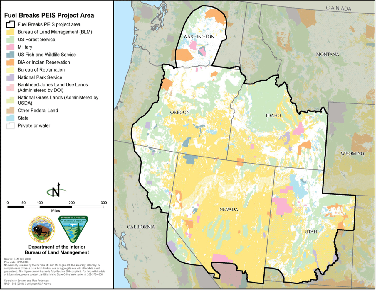
Rissien found, during the past quarter, USFS Region 4 – which covers southern Idaho, Nevada and Utah – proposed four projects that exceeded 100,000 acres each. One was 900,000 acres alone.

USFS Region 1, which includes Montana, northern Idaho and North Dakota, proposed 30 projects with CE’s last quarter, totaling more than 215,000 acres.

Logging projects intended to reduce insect or disease infestation or reduce hazardous fuels can be as large as 3,000 acres with some limitations. One CE created by the Forest Service for “timber stand and/or wildlife habitat improvement” has no acreage limit. Rissien found the Forest Service uses that for a majority of projects, and doesn’t even give a reason for others.

(There is also the “road maintenance” CE that has been the subject of litigation, including EPIC v. Carlson, here.)

There are some things to question in the article, but the slant of the article is not so much that what the Forest Service is doing is illegal, but that it is being done without much public information or awareness.  The article also points out that the Forest Service just seems to be following its marching orders from the president.  Tracking through the links gets you to this letter from the acting deputy chief, which says:

Consistent with this direction, Regional Foresters are to ensure that the Agency meet minimum statutory timeframes for completion of National Environmental Policy Act documentation and consultation with regulatory agencies. Categorical exclusions to complete this work should be the first choice and used whenever possible. I encourage you to explore creative methods and set clear expectations to realize this priority effort.

There’s a few points to make here.  I’m not aware of any “minimum statutory timeframes” for NEPA or consultation (the consulting agencies do have a deadline for providing a biological opinion).  I would translate “explore creative methods” into “take legal risks.”  Artificial deadlines aren’t creative, but they also result in legal risks.  Last is the implication that the use of categorical exclusions somehow avoids the need for an administrative record that shows that the use of the categorical exclusion isn’t arbitrary – that it fits the requirements of the category and does not have any extraordinary circumstances that could result in significant effects.  The lack of public review or an administrative objection process may save time, and it forces an opponent to sue, but it increases the risk of losing the case on an issue that could have been resolved before the decision.  (But if it gets points on the board during the game, does it matter what happens after?)  WEG said, “But we have to take their word for it since there is no supporting analysis we can review.”  If that’s what is really happening, it would eventually be a problem for the Forest Service in court.

More research on less tree growth after fire

(RJ Sangosti, The Denver Post)


This article summarizes some recent research on the topic:

Among Stevens-Rumann,’s work was a 2017 study of nearly 1,500 sites charred by 52 wildfires in the U.S. Rocky Mountains. Her research found that lower elevation trees had a tough time naturally regenerating in areas that burned between 2000 and 2015 compared with sites affected between 1985 and 1999, largely due to drier weather conditions.

More recently, a 2019 study written by her colleague Kerry Kemp found that both Douglas fir and Ponderosa pine seedlings in the Idaho’s Rocky Mountains — just south of B.C. — were also struggling in low-lying burned areas due to warmer temperatures, leading to lower tree densities.

Both studies attribute climate change to be the lead cause of why the trees are struggling to grow back in certain fire-scarred areas.

As a result, some ecosystems will no longer be able to support tree species. Instead they may convert to grasslands, she said.

We’ve talked about this before (for example, here).  But I would like to know how this kind of information is being incorporated into long-term planning for timber harvest levels. In accordance with the requirement for sustainability on national forests, we should be assuming forest growth consistent with the natural range of variation, which should reflect the effects of climate change on future forests.  What I would expect to be seeing based on this kind of research is reduced area suitable for timber production because it would become too dry, and reduced volume resulting from reduced density, slower growth rates and more frequent fires.  “Sustained yield” means that projections of lower future timber yields may lead to reduced near-term volume. I’ve looked at the timber volume documentation for a few forest plan revisions, and I haven’t found anything there about climate change (there’s usually an unconnected section on the effects of climate change somewhere).  (Projected timber harvest volumes are not tending to go down in revised forest plans.)  Maybe that just requires digging deeper than the public-facing documents or maybe it’s not happening.   Does anyone know more about this?

Let’s Discuss: Other D Candidates’ Wildfire Proposals

from this website https://www.270towin.com/2020-democratic-nomination

In yesterday’s post, I quoted from Bloomberg’s website. It’s harder to find this information for others, but this article in the Desert Sun, did a nice job of rounding up the other candidates’ answers (although like for my requests from the campaigns, not everyone responded). Thanks to Susan Britting for providing this link! Also note that Malcolm North, a Forest Service Research scientist, was allowed to talk to the press and even design a thoughtful question for the candidates.

Warren

Wildfires pose an especially serious threat to low-income communities, people with disabilities, and seniors. That’s why Elizabeth has committed to:

*Improving fire mapping and prevention by investing in advanced modeling with a focus on helping the most vulnerable — incorporating not only fire vulnerability but community demographics.
*Prioritize these data to invest in land management, particularly near the most vulnerable communities, supporting forest restoration, lowering fire risk, and creating jobs all at once.
*Invest in microgrid technology, so that we can de-energize high-risk areas when required without impacting the larger community’s energy supply.
*Collaborate with Tribal governments on land management practices to reduce wildfires, including by incorporating traditional ecological practices and exploring co-management and the return of public resources to indigenous protection wherever possible.
*She’s also committed to prioritizing at-risk populations in disaster planning and response and strengthening rules to require disaster response plans to uphold the rights of vulnerable populations. A Warren administration will center a right to return for individuals who have been displaced during a disaster and while relocation should be a last resort, when it occurs, she is committed to improving living standards and keeping communities together whenever possible.

My take: not so sure more modeling is needed, I’m assuming “more vulnerable” means old and/or poor and/or minority. It sounds like spending a lot of money to figure out how to prioritize spending money. This is one of those things that it would be interesting to see what it would look like in practice. Maybe poorer communities get fuel treatments around them, and richer communities need to pitch in? Perhaps it already works that way in practice. The idea of “returning public resources to indigenous protection wherever possible” sounds interesting. I’m not sure how I think the federal government should be involved in a “right to return.” Seems to me like something that should be worked out between people, communities, their local governments, and insurers.

Pete Buttigieg: wildfires are included in climate change and resilient infrastructure.

Tom Steyer:

As part of my Justice Centered Climate Plan, I will invest nearly $500 billion in the upkeep and protection of our watersheds, wetlands, national parks, and forests — and this includes fire management as well as protecting our clean drinking water. Because while some of the impacts of climate change are already here, there are levelheaded preventative measures we can take to protect ourselves and our forests from the worst dangers. My plan puts $555 billion into developing climate-smart communities and housing and an additional $755 billion into adaptation, resilience, and green infrastructure. This will ensure that the people who are displaced from fires and flooding have affordable places to live with access to green space. And it will also ensure that they have good-paying jobs building our new climate-resilient infrastructure, protecting our lands and waters, and serving communities hit by the climate crisis as long-term disaster recovery workers.

That’s a lot of money, but I’m curious about the “levelheaded preventative measures” and if those are the same as “developing climate-smart communities and housing” or “upkeep and protection” of private and federal lands.

Bernie Sanders:

We must invest now in mitigating these more frequent and severe wildfires, making our infrastructure more resilient, and preparing for disaster response. We must change our framework of fire suppression and forest management to take the whole local ecosystem into account, including the rural communities who are most vulnerable.

In California, developers are building houses in fire hazard zones, a move partially driven by the housing shortage. Bernie is committed to fully closing the 7.4 million unit shortage of affordable housing to guarantee housing to all as a right. We will work to ensure housing growth is climate-resilient, with experts and impacted communities included every step of the way.

We’ll expand the wildfire restoration and disaster preparedness workforce. We’ll increase federal funding for firefighting by $18 billion to deal with the increased severity and frequency of wildfires. Furthermore, we must facilitate community evacuation plans that include people experiencing homelessness, and increase social cohesion for rapid and resilient disaster recovery to avoid the use of martial law and increased policing in disaster response.

We’ll also amend the Stafford Act to ensure that FEMA ensures that recovery and rebuilding efforts make affected communities stronger than they were before the disaster so they are more resilient to the next disaster.

There are certainly many more voters (and delegates) in California, as the map above shows, so perhaps a California-centric view of wildfires is appropriate. Still, the relationship between housing shortages and living in fire-prone areas (grasslands, shrublands and forests) is more complicated in the Interior West than a lack of affordable housing in the cities. People would rather be here, and many are retired or work from home.

I like the idea of increasing social cohesion (but the martial law thing is a little scary). However, I wonder how politicians who spend their lives saying bad things about their opponents (and sometimes their supporters) can quickly spin to uniting people and community-building. I’ll be glad to see it if he is elected.

The other candidates apparently did not respond to the Desert Sun’s query (nor mine).

I’d have to give the “thoughtfulness about wildfire” aka “not just another climate issue” award to Bloomberg and Warren. Others have told me that they have more staff and that could be the reason. Certainly they are the only two who answered my questions, so there might be something to that. What do you think?

Let’s Discuss: Bloomberg’s Wildfire Resilience Plan

)

I’ve been trying to collect information on different D candidates’ positions on various federal lands policy issues. I was thinking we could take a candidate per day, but perhaps should have started sooner. Here is a link to a pdf

Mike will set a goal to reduce deaths and property losses from wildfires by 50% within four years. He will direct the U.S. Forest Service to coordinate with federal, state and local agencies, tribal leaders, environmental groups, rural communities, private timber companies, utilities, and the insurance industry to develop fire management plans for each state at risk.

Do States already have fire management plans? Would the goal possibly interfere with suppression choices to do WFU?

Double federal funding for fire management
Mike will double federal funding for fire management to $10 billion and devote half to mitigation efforts. These new resources will fund efforts to rapidly increase the pace and scale of forest restoration, reducing the risk of catastrophic wildfires. Federal money will also be directed to help fireproof homes and communities, develop evacuation plans, and strengthen other local resilience efforts, which will save lives, create jobs, reduce the costs and dangers of firefighting, and bolster insurance networks.

Of course, Presidents can’t actually double funding, but “increasing the pace and scale of forest restoration” sounds like another billionaire’s (currently President) policy. It’s nice to see some apparently bipartisan ideas.

Create a national Wildfire Corps to make communities more fire-resilient and restore healthy forest ecosystems
Mike will create a national Wildfire Corps, a new partnership between federal, tribal, state and local governments and communities. The Corps will hire and train thousands of workers to lead efforts to make communities more fire-resilient and restore healthy forest ecosystems. It also will provide enough firefighters to quickly contain wildfires when they break out.

I’m not sure that there is a lack of people if they were funded, perhaps there is, and/or a lack of training. I wonder if we asked fire people in communities would they see the same needs?

Use data and technology to detect and mitigate fires and to improve firefighting techniques. Mike’s administration will help fund a network of sensors and cameras to detect fires faster and more cheaply, and will strengthen the communications grid for public safety and emergency notifications. It will partner with state authorities to use satellites, drones, firefighting aircraft, and AI and communications technology to help predict the spread of fires and improve firefighting techniques.

Better technology.. why not?

What do you all think of these ideas?

BLM Great Basin fuel break EIS

The BLM has released its final decision to implement 11,000 miles of fuel breaks in six states.  The figure is in miles because the fuel breaks would be constructed along roads and right-of-ways.  Given our discussion of the Forest Service trend towards large landscape “condition based” management decisions, this language from an article quoting the BLM piqued my curiosity (my emphasis added):

According to Jennifer Jones, a spokeswoman for the BLM, the program will help streamline the implementation process by reducing or eliminating the need for environmental analysis. Once the plan is finalized and funding available, said Jones, “offices will be able to use it immediately and for many years to come.”

The timeline for implementation and the location of fuel breaks will depend on what offices develop plans and apply for funding.

The BLM’s notice of availability added:

… these potential treatment areas cover approximately 38 million acres within the project area boundary.

The goal of these Programmatic EISs is to significantly minimize the subsequent National Environmental Policy Act (NEPA) work required to approve on-the-ground projects.

(A second EIS will address “fuel reduction and restoration” over the same area.)

These statements sound like the more conventional approach to programmatic NEPA analysis (such as has been done for the use of herbicides).  They are intended to provide context for subsequent site-specific analysis that will produce overall savings in planning efficiency.  They make no pretense that this large scale analysis would necessarily be a substitute for site-specific analysis as some Forest Service proposals have stated. This kind of “merely programmatic” analysis has sometimes been given more leeway by the courts because a subsequent site-specific analysis would follow that would address site-specific issues and effects that have not been addressed.

The BLM decided also to do an EIS, unlike some of the Forest Service efforts that used an EA.  This analysis of effects of fuel breaks is also probably more site-specific than area-wide, “condition-based” Forest Service proposals because they know where the candidate corridors are, and they know the area of BLM lands where no action would be taken (away from these corridors).   (The scientific validity of fuel breaks is also discussed.)

Tahoe plan amendment for use of wildfires


(Not in the American Planning Association context of this publication, but in the NFMA context of national forests.)

I was alerted to the Tahoe situation by this supportive opinion piece in a local paper, which includes a link to the project record for the proposed plan amendment.  It provides an opportunity for a look at how fire management, and in particular wildfire management for resource benefits, should be addressed in national forest planning.  Fire and planning have had a rocky relationship in the Forest Service over the years, but here’s some current guidance.

Guidance for Implementation of Federal Wildland Fire Management Policy (February 2009) includes this:

Management response to a wildland fire on federal land is based on objectives established in the applicable Land/ Resource Management Plan and/or the Fire Management Plan.

Fire Management Plans, programs, and activities support land and resource management plans and their implementation.

The L/RMP will define and identify fire’s role in the ecosystem. The response to an ignition is guided by the strategies and objectives outlined in the L/RMP and/or the Fire Management Plan.

Values to be protected from and/or enhanced by wildland fire are defined in the L/RMP and/or the Fire Management Plan.

Wildland fire will be used to protect, maintain, and enhance resources and, as nearly as possible, be allowed to function in its natural ecological role. Use of fire will be based on L/RMP and associated Fire Management Plans and will follow specific prescriptions contained in operational plans.

Fire Management Plans are strategic plans that define a program to manage wildland fires based on the area’s approved land management plan.

The 2014 National Cohesive Wildland Fire Management Strategy required by the Federal Land Assistance, Management, and Enhancement Act of 2009 (FLAME Act), includes as a priority, “increasing use of wildland fire.”  Figure 3.4 shows a national map: “Spatial pattern of counties where options for managing wildfires
for resource objectives and ecological purposes might prove useful.”

The Forest Service Planning Handbook advises (among other things, §23.11c):

Standards or guidelines.  The plan may include standards or guidelines related to basic smoke management practices, non-fire fuels treatments, post-fire rehabilitation, prescribed fire treatments, and wildland fire responses.  A guideline or standard may provide guidance on when or how a specific tool is appropriate.

Here is the language from the current Tahoe forest plan (a standard):

Fire suppression strategy is control (with fast, aggressive initial attack) except where the contain strategy is authorized for specific management areas at fire intensity levels described under the practice description. Strength of attack will be based on hazard rating, fire weather, and values at risk.

The exceptions:

The Forest Plan allows Fire Managers to utilize fire for resource benefits in only a few limited areas of the Forest and only if the fire can be contained within an isolated fuelbed of 5 acres or less, a situation rarely encountered and at a scale too small to achieve meaningful ecological restoration or other resource benefits.

Here is the comparable language proposed for the amendment (a guideline):

Use naturally- (lightning-) caused wildfire ignitions to meet multiple resource objectives when and where conditions permit and risk is within acceptable limits. Multiple resource objectives include: re-introducing fire as a necessary ecological process; enhancing plant and wildlife habitat, including critical habitat for threatened and endangered species; improving forest health, conserving ecosystem services; managing smoke emissions; reducing fuel loading; and/or protecting communities and infrastructure.

So this all sounds like an improvement, but nowhere in the proposal or the discussion of the proposal does the Forest mention the role of the forest plan.  The “multiple resource objectives” should come from there.  They list 14 factors, and the only one that indirectly implicates the forest plan is “cultural and natural values at risk.”  A simple fix to the proposed guideline would be to use such ignitions to “achieve the desired conditions and objectives of the forest plan,” and add to the factor “… values at risk based on the forest plan.”  That should go without saying, but by failing to mention the plan, it suggests that decisions about prescribed wildfires could be made without reference to that document.  The forest plan may not be the first thing that comes to mind when a fire starts, but management of a fire, like everything else a national forest does, must be consistent with the applicable forest plan.

I do like the direct approach the Tahoe is taking with the smoke issue.

While the amendment could have short-term adverse effects on certain resources, for example, air quality, its effects would be largely beneficial by restoring the ecological role of fire and protecting forests and communities from the significant adverse effects of large-scale, uncharacteristic wildfire.

The proposed amendment is aimed at restoring air quality (36 CFR 219.8(a)(2)(i) by serving to offset smoke emissions from large, uncharacteristic wildfires


When forest plans are revised, a more comprehensive approach should be taken.  This will give you an idea what the Inyo has done.


Australia and US Wildfire, Similarities and Differences: III. Coverage of Negative Impacts of Wildfires on Wildlife and Water

A boom floats across a small bay near the dam wall at Warragamba Dam in Warragamba, Australia, on Wednesday, Jan. 29, 2020. Although there have been no major impacts on drinking water yet from the intense wildfires, authorities know from experience that the risks will be elevated for years while the damaged catchment areas, including pine and eucalyptus forests, recover. (AP Photo/Rick Rycroft)

In the last post in this series, we talked about “to what extent do models show that Australia and US wildfires are impacted by climate change?” Although that scientific work did not show Australia’s fires as necessarily having a big climate imprint, most of the stories I have read have focused on the climate angle. What is interesting to me is that that lens has led to many stories about the negative impacts of fires on wildlife and watershed.

In this AP story, the narrative is that bad/intense/hot fires lead to drinking water problems and flooding. The author even mentions the efforts of Denver Water to “clear trees and control vegetation” albeit perhaps not only in “populated areas” as the story says. There were also the stories (e.g., here in Scientific American) on wildlife deaths and burns. It’s true that Australia has many more unique species, so the loss in terms of biodiversity is different, but if you are a deer or elk or bear or raccoon, it would be equally unpleasant to be burned or killed by fire.

It seems that in the US there was a certain school of thought that fires were “natural” and so unpleasant effects to wildlife and water were just part of the deal, and in fact were particularly good for some species (while obviously not good for others, at least in the short term).

However, if you thought that the fires were “unnatural” due to previous fire suppression policies, then perhaps it might be more OK to intervene in terms of fuel treatments? Another question that perhaps was never discussed was how do you weigh making more habitat for one species compared to the deaths and injury to individuals of other species?

Looking back on the coverage, it looks to me like the narrative goes “climate change is bad and watershed and wildlife impacts from hot fires will be really bad” is a popular way to frame the Australian case. (If we don’t solve the international problem of climate change, the future looks worse and there are many negative impacts).

But in the US case, when the challenge was to do fuel treatments to help with suppression, (if we do prescribed burning and mechanical fuel treatments, it will help suppression folks deal with fires and lessen the likelihood of these negative impacts to wildlife and water) the same kinds of negative impacts to wildlife and water did not get as much press.

I’ve noticed in the press and in many climate science papers, as we shall see, predictions are made about bad things happening without acknowledging the efforts of other communities to dampen these effects. Some of these communities include fire suppression, plant breeding, water managers, and so on- each of whom have their own scientists who understand the mechanisms of responses and relevant uncertainties and unknowns. At the same time, other factors, such as fire suppression policies, or changes in prescribed burning practices, in the Australia example, may be overlooked in stories designed to attract attention in relatively small space. My concern is that it could make people more despairing and fearful about the future than they might be given what is known by all these scientific communities. Fear leads to anger at “the other” and the idea that the ends justify the means, and the accompanying unpleasant impacts to our society of that worldview.

Does anyone doubt that the western US and Australia would still need to deal with wildfires if there were no climate change? Hint: existence of fire-adapted plant and animal species.

Helena project clears the 9th Circuit, except for some “WUI”

Fine specimen of a real antique Morse code telegraph machine.
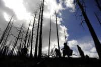
Copyright: Photowitch | Dreamstime.com

The Ninth Circuit Court of Appeals has upheld the Telegraph Vegetation Project on the Helena-Lewis and Clark National Forest, except for one question about the location of the Wildland Urban Interface (WUI).  The case was previously described on this blog here.  That description included this allegation by plaintiffs:

Agency used non-federal definition of the Wildland Urban Interface 


“While the lynx amendment allows logging in the Wildland Urban Interface, it also defines the Wildlife Urban Interface to be within one mile of communities,” Garrity explained. “But the Forest Service used a new definition provided by local counties and then remapped the Wildland Urban Interface to include areas over five miles away from communities.”

The court remanded the decision for 50 acres of the 5000-acre plus area to be treated, and left the record of decision in place while the Forest Service completes its reevaluation:

“The Forest Service has acknowledged that it erred in calculating the wildland-urban interface for the project area. The Forest Service estimates that, once it has corrected its error, 50 acres of forest that it had planned to treat may no longer be eligible for treatment. If that estimate proves correct, the Forest Service represents that it will not treat those 50 acres. We grant the government’s request for a voluntary remand to allow the Forest Service to undertake the necessary reevaluation.”

I have been interested in how WUI is identified, by whom, and using what process under what authority – especially the role of non-federal parties.  WUI is generally  identified based on the Healthy Forest Restoration Act of 2003 (HFRA).  Areas identified using that process qualify for streamlined projects in accordance with HFRA, and may be eligible for particular funding.  However (in accordance with HFRA), WUI projects are still subject to requirements of the governing forest plan.  Management direction for lynx is part of the forest plan, and this article (like plaintiffs) suggests it imposes greater restrictions on part of this project:

“In the second portion of the court’s order, the Forest Service proposed logging and thinning in areas defined as the “wildland-urban interface,” which is where houses or cabins meet the forest. Regulations related to lynx allow the removal of some trees and vegetation in lynx habitat if it falls within the wildland-urban interface and if the agency shows it is part of a wildfire mitigation project. The alliance inspected the area and reported only a handful of houses. The Forest Service conceded in court documents that it erred in calculating the size of the wild-land urban interface based on discrepancies between what qualifies.”

However, this actually indicates that the problem was in the definition of “community” (based the on number of houses), rather than the distance from one.  In fact, the Northern Rockies Lynx Management Direction refers to WUI “as defined by HFRA.”  Those definitions and criteria for “WUI” and “at risk community” are summarized by the Forest Service here.  Although which communities are to be included (they can self-identify) are mostly listed in the Federal Register, that doesn’t address their boundaries.  The district court opinion upheld the Forest Service WUI designation, stating that, “The Powell County Plan does not begin with the HFRA definition; it creates its own, “and “the Court is not persuaded by Council’s attempt to discredit the map provided by the Forest Service in the Telegraph Project EIS” based on that county plan. Yet it sounds like the map may have been wrong in this case.  This all reminds me of my take-home from my Forest Service days that “WUIs are fuzzy.”

Here’s why this might be important to planning.  I agree with the idea that forest plans (like the lynx direction) should identify areas with differences in long-term management that result from a wildland-urban influence.  However, if the WUI definition refers to another source (HFRA and a local plan), instead of being specifically defined in the plan itself through criteria and/or a map, there may be confusion about where and how the plan applies (as seems to be the case here).  (Yes I’m criticizing the lynx strategy for doing that; they didn’t take my advice.)  In addition, if external decisions about WUI locations change, the Forest Service may have to publicly consider whether to adopt that change in its forest plan (that situation wasn’t addressed in this case).  I’m also contrasting “decisions” with new “information” that affects how an existing decision applies (e.g. someone building a new house), which must be considered in a planning context but doesn’t necessarily trigger a plan amendment.  (A court has held that even changes in something like criteria for maps of lynx habitat must be considered in a public planning process when forest plan direction is tied to it.)

(The other issue addressed by the 9th Circuit in its short opinion was the ESA consultation process for grizzly bears.  The court approved a consultation process that tiered to forest plan decisions and consultation, which lead to streamlined project consultation.  The value of forest plan consultation has been questioned, but that value is evident here.)


Australia and US Wildfire, Similarities and Differences: II. How Much is Due to Anthropogenic Climate Change?

Time of emergence of anthropogenic climate change for (a) the frequency of days exceeding the 95th percentile, (b) the length of the fire weather season, (c) the peak 90‐day average FWI, and (d) annual maximum FWI. Mapped is the 17‐model median date at which the anthropogenic signal emerges based on the change exceeding the standard deviation of the baseline period. Areas of light gray highlight where the signal does not emerge for at least eight models by 2050. Unburnable lands where >80% of the area is water, snow, and ice or barren or sparsely vegetated are shown in dark gray. The percent of burnable land with emergence by 2050 is denoted in the bottom left corner of each map.

The above maps are from this paper by Abatzoglou et al.

Here’s a link to a Science Brief from the University of East Anglia about climate and wildfires. It’s kind of like a scientific rapid response team when an issue comes up, which made it easy to compare the Western US and Australia in terms of ACC.

First, here’s Australia

Climate change also affects fire weather in many other regions, although formal detection does not yet emerge from natural variability. ​Abatzoglou ​et al. (2019) suggest that the anthropogenic climate change signal will be detectable on 33-62% of the burnable land area by 2050. Other global studies agree that the effect of climate change is to increase fire weather and burned area once other factors have been controlled for (e.g. Huang ​et al.​, 2015; Flannigan ​et al.,​ 2013). ​Regional modelling studies corroborate these global findings by projecting how climate change will affect fire weather:…

Australia. Observational data suggest that fire weather extremes are already becoming more frequent and intense (Dowdy, 2018; Head ​et al.​, 2014). However, the divergence between anthropogenic and natural forcing signals is weaker, and more challenging to diagnose, than in other regions due to strong regional and inter-annual variability in the effect of the El Niño–Southern Oscillation on fire weather (Dowdy, 2018; Sharples ​et al.​ , 2016). ​Other important regional weather patterns, such as the Indian Ocean Dipole (IOD) and the Southern Annular Mode (SAM) also contribute to natural variability in fire weather, but their effects are increasingly superimposed on more favourable background fire weather conditions. ​Impacts of anthropogenic climate change on fire weather extremes and fire season length are projected to emerge above natural variability in the 2040s (Abatzoglou​ etal.,​ 2019)

Then here’s the western US:

The impact of anthropogenic climate change on fire weather is emerging above natural variability. ​Jolly et al. (2015) use observational data to show that fire weather seasons have lengthened across ~25% of the Earth’s vegetated surface, resulting in a ~20% increase in global mean fire weather season length. By 2019, models suggest that the impact of anthropogenic climate change on fire weather was detectable outside the range of natural variability in 22% of global burnable land area (Abatzoglou et al., 2019). Regional studies corroborate these global findings by identifying links between climate change and fire weather, including in the following regions with major recent wildfire outbreaks:…

Western US and Canada. Models suggest that the impacts of anthropogenic climate change on fire weather extremes and fire season length emerged in the 2010s (Abatzoglou ​et al.,​ 2019; Williams ​et al​., 2019; Abatzoglou & Williams, 2016). Yoon ​et al​. (2015) similarly predicted the occurrence of extreme fire risk would exceed natural variability in California by 2020. Kirchmeir-Young ​et al​. (2017) found that the 2016 Fort McMurray fires were 1.5 to 6 times more likely due to anthropogenic climate change, compared to natural forcing alone. Westerling ​et al. (2016) found that burned area was >10 times greater in Western US forests in 2003-2012 than in 1973-1982. The 2015 Alaskan wildfires occurred amidst fire weather conditions that were 34-60% more likely due to anthropogenic climate change (Partain ​et al.​, 2016).

Note that the claims are sometimes models and sometimes empirical. For example, the increase in burned area noted by Westerling may have had many reasons besides changes in fire weather.

If we accept the Australian claim at face value (differences due to anthropogenic climate change expected to show up in the 2040’s) then they have some time to get their prescribed burning and other programs up to speed before the additional problems due to ACC surface. In that case, it looks like they have about 20 years before they get the additional problems due to ACC. However, if climate modelers don’t understand the natural cycles or anthropogenic factors well enough, though, as seems likely, conditions could be worse sooner or later than the 2040’s. So the Aussies and us, despite the difference in model predictions both need to get on with prescribed burning, building and community design, improving suppression and all that.

As the authors state:

Nonetheless, wildfire occurrence is moderated by a range of factors including land management practises, land-use change and ignition sources.

Australians and US Wildfire, Similarities and Differences: I. Knowledge of Traditional Burning Practices

Hot fires such as this over large stretches of country can have detrimental effects on all sections of the forest depleting the seed stock and promoting germination that is too intense, destroying ground cover, and destroying canopy and the fauna that is associated with it.(from the Kelly paper)
Photo – Jiri Lochman

As the world’s attention has turned to the tragedies of the recent and ongoing Australian bushfires, it has been an opportunity for some of us to learn about bushfires, their history, and how Australians have handled them and perhaps compare their history and solutions to our own.

One theme that has been reoccurring on The Smokey Wire recently is that of looking at the written and oral histories of Native land use practices and land uses by non-Native settlers in the 19th and early 20th century. For me, it’s not about replicating the past, so much as understanding how and why Native peoples managed it and how the forests we see today were established.

I recently ran across this interesting piece by a Nyungar man named Glen Kelly in Landscope, a publication of Western Australia Department of Biodiversity, Landscape Conservation and Attractions. I couldn’t find the year it was published. In the paper is this quote from 1830:

While travelling from the Albany District to Perth in November 1830, John Lort Stokes wrote that:

“On our way we met a party of natives engaged in burning the bush, which they do in sections each year. The dexterity with which they manage so proverbially a dangerous agent as fire is indeed astonishing. Those to whom this duty is especially entrusted, and who guide or stop the running flames, are armed with large green boughs, with which, if it moves in a wrong direction, they beat it out … I can conceive no finer subject for a picture than a party of these swarthy beings engaged in kindling, moderating and directing the destructive element, which under their care seems almost to change its nature, acquiring as it were, complete docility, instead of the ungovernable fury we are accustomed to ascribe to it. Dashing through the thick underwood, amidst volumes of smoke-their dark active limbs and excited features burnished by the fierce glow of the fire-they present a spectacle which rarely falls to our lot to behold, and of which it is impossible to convey any adequate idea with words.”

Through the fog of racial bias, you can detect the author’s awe at the native peoples’ fire and land management skills.

But changes in land management have also occurred post-settlement, in fact, somewhat recently.

“that upon the cessation of Nyungar land management practices, dramatic changes occur to the land. Up until 20 or 30 years ago, Nyungar land management practices, which involved frequent cool fires over much of the country, were maintained to a large extent by the cattlemen of the south coast. They used the skills shared with them at the time of settlement, when a major part of the rural work force was Nyungar people. In the last few decades, however, we have witnessed some parts of our coastal land move from productive and vital areas to what we consider sick (mindytch) or dead country (noinch boodja). ”

Again, I don’t know the date of this piece, but Kelly was not finger pointing, but simply calling for:

We believe that the experimental non-use of fire and inappropriate use of fire that has been applied on the south­west coastal lands for the past few decades has been detrimental to the land of our origin. The fault for this does not lie at the feet of any one group or agency, but is a collective responsibility that needs to be recognised and rectified, quickly.

The whole paper is interesting as it places fire in the Nyungar cultural context.

If I had to guess, I would think that in the US, traditional burning knowledge and practices have been passed down in some places and not in others, due to the uprooting of Native people from their land and other factors. It would also be interesting to scan documents and journals from the 17 and 1800s for mention of then-current burning knowledge and practices. I wonder whether anyone has done that?