Yosemite’s Re-re-Burn

The El Portal Fire, burning in Yosemite National Park and the Stanislaus National Forest, has taken a familiar path. Starting very close to where the 1989 A-Rock Fire began, it easily burned up the steep canyon slopes, out of reach of firefighters. Not too many people are making the connection between this set of fires, the A-Rock, the Big Meadow and now the El Portal Fire, and the Rim Fire re-burn (and its prior fires).

Below is what the Foresta area looked like in November. Did those green trees survive this fire? We can’t be sure until the bark beetles have decided their fate, over the next few years. The forested slopes in the background were salvaged under the original A-Rock salvage project, and you can see that it looks about as good as a burned and salvaged landscape can be. Parts of that ridge top have had 13 fires in the last 100 years. The northern third of the fire burned into areas partially burned in the Big Meadow Fire. Up there, fuels are much heavier, and some of it had made it to the ground.

Edit: The fire’s boundary has slopped over that far ridge top but, there is less fuel on that dry west-facing slope, and the fire is just smoldering at the north end. Now, with more re-burn! It will be interesting to see how intense it was, burning through the salvaged part of the A-Rock Fire.


P9132004-web

So, how long do you think it will take to turn this former pristine old growth stand back into a viable forest? Remember, this was a prime summer site for Indians, who expended a lot of time and energy to manage the ladder fuels. You can also go see the bigger picture here, at https://www.google.com/maps/@37.7045826,-119.7624808,7211m/data=!3m1!1e3?hl=en The northern end is very close to Crane Flat. Suppression costs have topped 8 million dollars. Also, how long will it take before blackbacked woodpeckers are on THIS piece of land? We need to learn from this example, or be doomed to repeat this moonscape.

P9132021-web

New Aerial Photos of the Rim Fire

Google Maps now has updated photos that include the Rim Fire. Now, we can explore the whole of the burned areas to see all of the damages and realities of last year’s epic firestorm.

P9132051-web

.

Here is where the fire started, ignited by an escaped illegal campfire. The bottom of this deep canyon has to be the worst place for a fire to start. It’s no wonder that crews stayed safe by backing off.

http://www.google.com/maps/@37.8374451,-120.0467671,900m/data=!3m1!1e3?hl=en

.

While there has been talk about the forests within Yosemite National Park, a public assessment has been impossible, in the National Forest, due to closures. Here is an example of the plantations I worked on, back in 2000, completed just a few years ago. What it looks like to me is that the 40 year old brushfields caused most of the mortality within the plantations. A wider look shows some plantations didn’t survive, burning moderately. When you give a wildfire a running start, nothing can stand in the way of it.

http://www.google.com/maps/@38.0001244,-119.9503067,1796m/data=!3m1!1e3?hl=en

.

There is also a remarkable view of Sierra Pacific Industries’ partly-finished salvage logging. Zoom into this view and take a look at their latest work, including feller-bunchers. Comments?

http://www.google.com/maps/@37.9489062,-119.976156,3594m/data=!3m1!1e3?hl=en

More Rim Fire Pictures

All too often, once a firestorm goes cold, a fickle public thinks the disaster is over with, as the skies clear of smoke. In the situation of the Rim Fire, the public hasn’t had much chance to see the real damages within the fire’s perimeter. All back roads have been closed since the fire was ignited. Besides Highway 120, only Evergreen Road has been opened to the public, within the Stanislaus National Forest.

From my April trip to Yosemite, and Evergreen Road, this unthinned stand burned pretty hot. This would have been a good one where merchantable logs could be traded for small tree removal and biomass. Notice the lack of organic matter in the soil.

P9202313-web

Sometimes people say there is no proof that thinning mitigates fire behavior. It’s pretty clear to me that this stand was too dense and primed for a devastating crown fire. I’m guessing that its proximity to Yosemite National Park and Camp Mather, as well as the views from Evergreen Road have made this area into a “Park buffer”. Now, it becomes a “scenic burn zone”, for at least the next few decades.

P9202306-web

There is some private land along Evergreen Road, which seem to have done OK, at least in this view. Those mountains are within Yosemite National Park. Sadly, the media likes to talk about “reduced burn intensities, due to different management techniques”, within Yosemite National Park. Only a very tiny percentage of the National Park lands within the Rim Fire have had ANY kind of management. Much of the southeastern boundary of the fire butts up against the Big Meadow Fire, generally along the Tioga Pass Road (Highway 120). Additionally, much of the burned Yosemite lands are higher in elevation, as well as having larger trees with thicker bark. You can also see that there will be no lack of snags for the blackbacked woodpecker. Can anyone say, with scientific sincerity, that over-providing six years of BBW habitat will result in a significant bump in birds populations? The question is really a moot point, since the Yosemite acreage, alone, does just that.

P9202301-web

People have, and will continue to compare the Yosemite portion of the Rim Fire to the Stanislaus National Forest portion, pointing at management techniques and burn intensities. IMHO, very little of those comparisons are really valid. Apples versus oranges. Most of the Forest Service portion of the fire is re-burn, and there is no valid Yosemite comparison (other than the 2007 Big Meadow Fire). It has been a few months since I have been up there, and I expect that there are plenty of bark beetles flying, and the trees around here have no defense against them, with this persistent drought. Everything is in motion and “whatever happens” is happening.

This Is How Much America Spends Putting Out Wildfires

unbalanced budget

Here is an interesting article, with great graphics from Mother Jones Magazine. I just have a small extract here so you can get a flavor, but check out the links and graphics in the original.

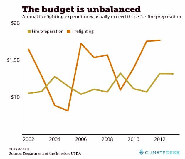
Indeed, firefighting expenditures have consistently outpaced fire preparation expenditures, even as experts like Covington and Douglas insist that, like the adage says, an ounce of prevention is worth a pound of cure. Since 2002, the average dollar spent on firefighting has been matched by only 80 cents in preparatory spending on things like clearing away hazardous fuels and putting firefighting resources in place:

Wyden’s bill, which he calls “arguably one of the first bipartisan efforts that could make a real dent in climate change,” is still in committee, and the House version has already taken heat from fiscal conservatives like Paul Ryan (R-Wisc.). In any case, it wouldn’t take effect until next year. But Covington argues that the government needs to approach wildfires as natural disasters on par with hurricanes and earthquakes, and that we should plan for a future that is much more severe than the past.

“Earlier in the century, if they saw what’s been going on since the ’90s, it’s just inconceivable,” he says. “It alarms me that people don’t realize how much is being lost.”

Some thoughts..

1)There are many sources of increased costs, as we have discussed here before. More rules, better equipment, etc.

2) I like that the article says “they are able to extinguish most fires when they are relatively small.” I wonder how that tracks with various let-burn policies, though.. as in “we are able to extinguish them, but we don’t.” And if they don’t, how many of the larger fires does that explain? If we let some fires burn on purpose, wouldn’t acreage increase over the time we didn’t?

3) I thought this was interesting… “In 2006, Westerling counted instances of fires greater than 1,000 acres in Western states; the study, published in Science, found that “large wildfire activity increased suddenly and markedly in the mid-1980s.” But CO2 I don’t think increased “suddenly” so I wonder if there is another explanation?

4) I found this quote intriguing, if you think about it..
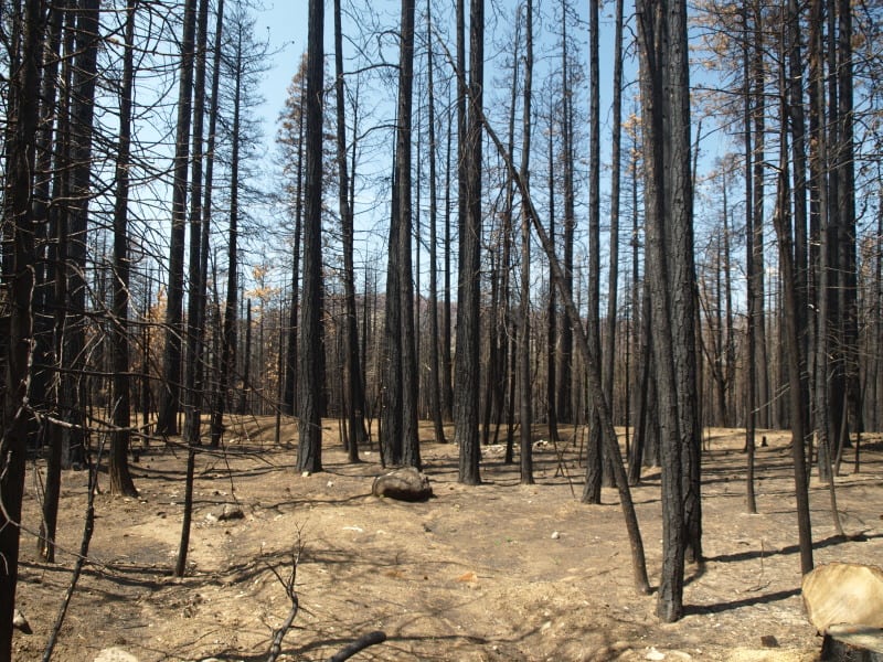
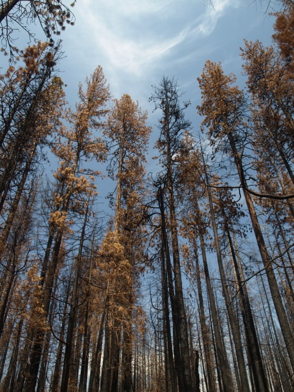
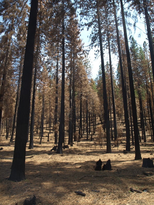
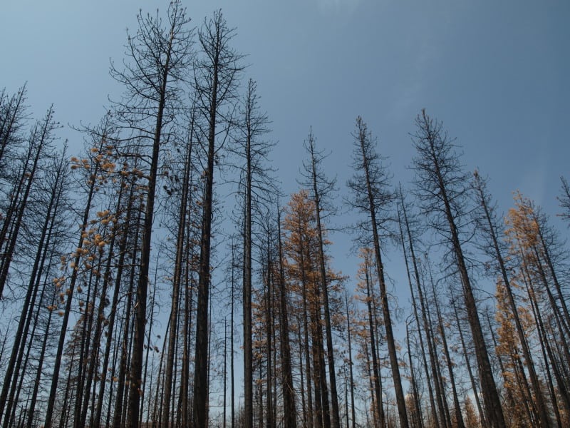
“Environmental change is complicating the work of fire managers who already had their work cut out for them restoring forests from the decades-long practice of suppressing all fires, which led to an unhealthy buildup of fuel that can turn a small fire into a megafire.”

Well, fire managers planned to “restore” forests that have an “unhealthy” buildup of fuels. It seems like there are only two ways of doing it..mechanical treatments and prescribed burns or some combination, if, in fact, we are talking about forests that have “unhealthy buildups.” Since it is really hard to do either one (litigation on mechanical, safety and health on prescribed burns) the idea that this will happen across all acres in the west, even with unlimited bucks, seems unrealistic to me. Maybe we need some more realistic ideas like “climate change has made fires unpredictable and scarier. Therefore we should do more mechanical fuel treatments.. enough to make a difference and protect communities, and be very very careful with prescribed burns and fire use.” Climate change makes things worse, but just makes us want more money, not change our approach?

5. I like that this article says that “80 cents in preparatory spending on things like clearing away hazardous fuels and putting firefighting resources in place” so hazardous fuel treatment is a good thing, yet as we have seen in the pages of this blog, those projects can be hung up for years in some cases due to the way appeals and litigation works.

6. In this Mother Jones article, people who argue for fuels treatment projects are Democrats (Wyden) and those against, Republican (because of the bucks). For those of us who have sat through House and Senate hearings, it’s a fascinating take.

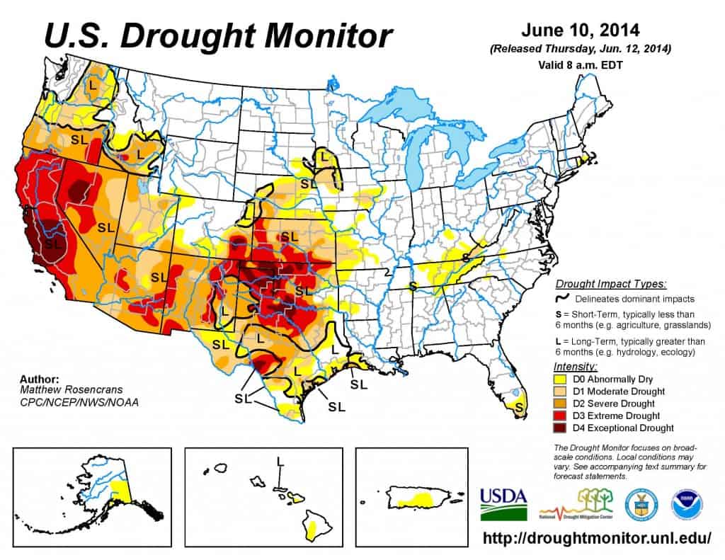
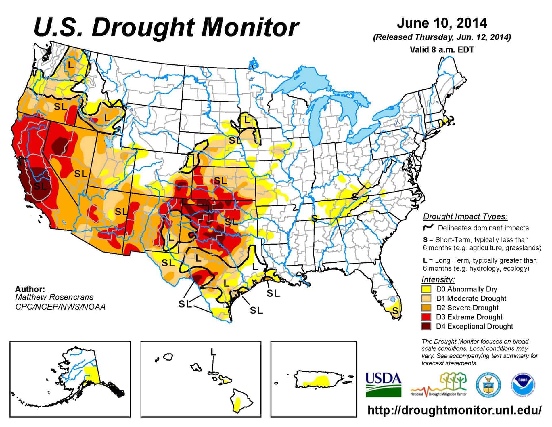
7. Finally, if you’re in the west, and you’re thinking “but we don’t have a drought, here, it’s been raining all spring and summer” you can find yourself in the helpful map below. Here is a link for more info.

drought

Move-On Petition on Wildfires from Nancy Freeman

I think this is the Canyon uranium mine on the Kaibab.

Nancy Freeman sent me this link to a Move-On Petition she started with regard to wildfires:

Please mandate that Forest Service and Department of Interior agencies designate our tax money for emergency measures to prevent wildfires now. The drought in the West makes the situation urgent. According to the National Interagency Coordination Center, there are 7 uncontained and 3 new wildfires on public lands on May 31, 2014.

The Government must act now to accomplish:
1) Stopping any industrial activities in the forests that contribute to wildfire danger.
2) Clearing of excess fuel: underbrush and ladder brush
3) Creating fire lines with environmentally friendly mechanical mulches
4) Instituting fire safety education and inspections in communities located in potential wildfire areas.

See http://www.g-a-l.info/ForestFireReport.htm for detailed information.

Here’s her argument:

The major causes of forest fires are nature, lightning, and human: campfires and cigarettes; however, faulty electrical wiring, sparks from vehicles and sparks from welding machinery are common, plus flames produced by hazardous waste spills from truck accidents on public lands. An overheated BLM vehicle caused the Chariot Fire that burned 7,000 acres in the San Diego Forest in July 2013. http://wildfiretoday.com/2013/07/08/california-chariot-fire]

Since industrial projects, especially mining operations, bring all but one of these “human cause” risks to the National Forest, it is clear that an increase of mining industry in our National Forests increases the fire risk. We have two examples in the region I live in Arizona.

In May 2011, two mining companies caused fires in the Coronado National Forest with welding projects. At the time, the “Fire Danger” was at Level 1: campfires and cigarettes are prohibited; yet in both cases the miners were out-of-doors welding in May. May and June are the hottest, driest months in the Southwest, which forest fire data confirms. A further complication is that industrial sites are surrounded by 10 ft. high chain-link fences for security reasons, making it impossible for fire fighting equipment to enter multiple acres of National Forest public land, except at a main gate.

Considering there are 170 mining operations being permitted in 44 National Forests in the West [www.mining-law-reform.info/proposed-mining-projects.htm], the fire danger from industrial mining needs to be addressed. National Forest Service record of mining project on the National Forest: FSOperations Records.

Sharon- I guess my problem with this (only having worked on forestry, grazing, oil and gas, underground and aboveground coal projects, powerlines, ski areas) is that while folks out there may cause some fires, they also put them out (their own and campers’, hunters’, and so-called “natural” ignitions). I don’t know the ratio of “start” to “put out”, but I’m not sure anyone else does, either.

I am curious about the problem with gates and firefighting, not sure I’ve heard about this before.

South on Wildfires and Climate Change

Pages from south on fire

Thanks to the SAF Linked-In group for this one. Here is a link to a story about Dr. South’s testimony to the Senate Energy Committee.

Here are a couple of excerpts:

Untrue claims about the underlying cause of wildfires can spread like “wildfire.” For example, the false idea that “Wildfires in 2012 burned a record 9.2 million acres in the U.S.” is cited in numerous articles and is found on more than 2,000 web sites across the internet. In truth, many foresters know that in 1930, wildfires burned more than 4 times that amount. Wildfire in 2012 was certainly an issue of concern, but did those who push an agenda really need to make exaggerated claims to fool the public?

Here is a graph showing a decreasing trend in wildfires from 1930 to 1970 and an increasing trend in global carbon emissions. If we “cherry pick” data from 1926 to 1970 we get a negative relationship between area burned and carbon dioxide. However, if we “cherry pick” data from 1985 to 2013 we get a positive relationship. Neither relationship proves anything about the effects of carbon dioxide on wildfires since, during dry seasons, human activity is the overwhelming factor that determines both the number and size of wildfires.

(I (SF) would argue that changes in suppression tactics/capabilities/technology are difficult to separate from other factors over time).

And

Untrue claims about the underlying cause of wildfires can spread like “wildfire.” For example, the false idea that “Wildfires in 2012 burned a record 9.2 million acres in the U.S.” is cited in numerous articles and is found on more than 2,000 web sites across the internet. In truth, many foresters know that in 1930, wildfires burned more than 4 times that amount. Wildfire in 2012 was certainly an issue of concern, but did those who push an agenda really need to make exaggerated claims to fool the public?
Here is a graph showing a decreasing trend in wildfires from 1930 to 1970 and an increasing trend in global carbon emissions. If we “cherry pick” data from 1926 to 1970 we get a negative relationship between area burned and carbon dioxide. However, if we “cherry pick” data from 1985 to 2013 we get a positive relationship. Neither relationship proves anything about the effects of carbon dioxide on wildfires since, during dry seasons, human activity is the overwhelming factor that determines both the number and size of wildfires.

Anyone is welcome to find other quotes of interest.

When I was at work, I often wondered “what difference does it make whether and how much current fires conditions are caused by climate change or not?” (Many climate scientists say it is too late to fix short-term changes). Would it make a difference in the 1) fire resilience planning for communities? 2) strategy for fuel treatments? 3) fire suppression? If so, how?

Note:I’m not picking on Dr. South here, the question has been raised by journalists and others, so a debate needs to happen. My point is: given that all this is extremely complex, what difference would different answers make in practice?

Fire Borrowing Impacts Colorado- from Bob Berwyn

To paraphrase an old song "the funding my friend is blowing in the wind..."
To paraphrase an old song “the funding my friend is blowing in the wind…”

Thanks to Bob Berwyn for this one..

Below are some excerpts:

FRISCO — U.S. Forest Service officials said they’ve had to defer reviews of ski area projects, delay trail improvements and forest restoration work because of the high cost of fighting wildfires. This year, the agency projects a $470 million gap that ripples through the entire Forest Service budget.

More than a dozen important projects in Colorado were on the hit list, according to a new report released this week by the Department of Agriculture. Some of the projects were canceled altogether because their funding has been diverted to fighting wildfires.

In Colorado, the following projects have been affected:

*Recreation Special Use permits for outfitter guides were deferred and ski area applications for four season use improvements were deferred.
*Emergency repairs on the Pike-San Isabel National Forests and Cimarron and Comanche National Grasslands were reduced to only critical repairs.
*A project to replace boundary signs that were destroyed in the High Park fire was canceled.
*Over 25,000 acres of ecosystem assessments, part of forest-wide inventories, were not accomplished.
*The Aquatic Nuisance Program (invasive species) with the State of Colorado was not funded.
*The Beaver Brookland acquisition project on the Arapaho-Roosevelt National Forest wasn’t funded.
*A $72,000 project to clear downfall and conduct related trail maintenance in areas affected by the bark beetle was deferred.
*Facilities improvement projects at the Lottis Creek Kiosks and the Crested Butte Forest Service housing were not completed.
*Abandoned mine mitigation work on the Akron Mine and Mill Site in Gunnison National Forest was deferred.
*Over $400,000 in watershed projects was deferred.
*Over $300,000 in wildlife management projects were delayed, deferred, or canceled.

Governor Talks Pot, Planes

A version of this article showed up in my “paper” Denver Post this morning. It’s an article on the Western Govs meeting. It might be interesting to compare with other western states’ press.

Here’s the quote about planes:

President Barack Obama on Monday spoke with the governors via telephone to discuss new funding strategies to fight wildfires — a persistent problem that is expected to worsen in Colorado in the decades to come, officials say. Colorado this year set aside about $20 million to contract for an aerial fleet to fight wildfires.

Hickenlooper, a Democrat, joked that the other governors on the panel will now want to borrow Colorado’s aircraft and that the state “will be generous” with helping out.

Bullock, a Democrat, said Montana each year sets aside money to fight wildfires, which he said “are almost always certain.” Sandoval, a Republican, noted that about 80 percent of Nevada is federal land.

“Because of that, there has to be proportional contribution from the federal government,” said Sandoval. “We can’t afford to buy planes to put out fires on federal land.”

It seems that the western govs think that planes (and therefore retardant) can be helpful at firefighting. Not just the Forest Service (this relates to previous discussions here and elsewhere).

Somewhat Related Note: if you read this article, you will note that Governor Hickenlooper mentions the Maureen Dowd op-ed on her eating of marijuana edibles. I think it’s interesting that the views of one op-ed writer for the Times becomes fodder for the Governor of a state to discuss. And if you’re curious, here’s a rejoinder by Vincent Carroll on some background to her piece (yes, we have an online section of the Post called “The Cannabist.”).

Person writes misleading op-ed. Governor ends up dealing with it. Would that have happened if the op-ed had been, say, in the Idaho Statesman? What kind of power does this kind of national media have, and are they using it wisely? How many people will read her op-ed, compared to those who read both hers and Carroll’s piece?

Rim Fire Terrain Effects

Below is a picture of the Tuolumne River and Poopenaut Valley, just a mile or so below Hetch Hetchy’s O’Shaughnessy Dam. As you can see, the area burned rather lightly. What might be the reason for this area to survive, almost unscathed? I think there is a “micro-climate” at play, here. Most of this is Yosemite National Park.

P9202324-web

Certainly, there are plenty of fuels, and California is in a historic drought. Firefighters did not “heroically” save this area from the flames. No management was done to make this area more resilient. Comparing this area to scorched places downstream, I think I have the answer. Farther downstream, the fires were enhanced by the nearly constant breeze, flowing down during the night and morning, and flowing up, with the heat of the day. Cold air sinks and warm air rises. This spot is pretty unique along the Tuolumne River. As the canyon turns from a glacier-sculpted valley into a V-shaped gorge, the cold air from higher elevations runs into this bottleneck, pooling up in this last valley, going downstream. Temperature inversions stay longer and stabilize the breezes, reducing fire behaviors.

One thing I did notice in this area was that many single digger pines were “selectively burned” as individuals. Those long slender needles were good at catching the small embers.

Burn Intensity in the Rim Fire

I ventured into the Rim Fire, where access is (still) very limited, and found a variety of conditions. Along Evergreen Road, on the way into the Hetch Hetchy area of Yosemite National Park, I first saw an area that had a prescribed burn accomplished, a few years ago. A “windshield survey” of that saw that there were plenty of trees surviving. I wasn’t surprised to see scattered mortality. It remains to be seen how many of these green trees already have bark beetles in them. In fact, I’m sure that some trees have changed color since I was there, in late April.

Farther up the road, near the historic Camp Mather, I saw this managed area and wondered why it didn’t survive very well. You can see that understory trees were cut, reducing the ladder fuels. Farther up the gentle slope there appears to be some survivors. All of the trees in this picture are likely candidates for bark beetles, and the green ones can support more than one generation. We are already seeing accelerated bark beetle mortality outside of the fire’s perimeter.

P9202311-web

I scanned around, looking for a reason why the stand had so much mortality. Looking across the road, down the hill, I saw the reason why. It is pretty clear that this stand hadn’t seen any management, and the hot wind from the fire pushed the crown fire across the road. Some of those trees were simply just “cooked” by the hot gases, blowing through their crowns. While I have seen these fire-resilient pines sprout some buds the next spring, few of them survive through the next summer, for multiple reasons.

P9202312-web

With over 250,000 acres burned, of course there will be a varied mosaic, with lots of examples of things we like to talk about, no matter what your point of view is. I will post more examples of what I saw in future posts.