Black Hills ghost trails come alive

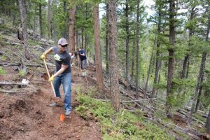
Two existing but unauthorized recreational trails will be considered for inclusion in the Black Hills National Forest’s official non-motorized trail system. But the trails were apparently blazed by users rather than Forest Service officials, and neither trail is considered part of the forest’s official trail system.

Just two years ago, the then-ranger of the Forest’s Mystic District, Ruth Esperance, threatened to criminally prosecute builders of unauthorized trails. The threat provoked a backlash among trail users, especially in the mountain-biking community, who accused forest officials of longstanding inaction on proposals for new trails.

In other words, they got tired of waiting and just decided to do it themselves, and the Forest Service is about to sanction that.  Meanwhile, four other proposed trails were set aside for now by Forest Service officials, who considered a total of six proposed trails as part of a new trail-proposal process that was created in August.  They were not approved because of unacceptable impacts.

Van Every identified numerous problems with the Storm Mountain and Victoria Lake trails. “Issues include routes through documented cultural sites, crossing private property, permitting bicycles on the historic Flume Trail where they are currently not authorized, crossing a major highway, fence crossings in the Foster Gulch area, lack of parking, and potential conflict with big game winter range,” Van Every wrote…  Furthermore, Van Every wrote, the Paha Sapa trail goes through the Norbeck Wildlife Preserve, where trail miles are limited by the Black Hills National Forest’s management plan.

For the two trails that were advanced for further review, several more steps in the process remain, including environmental reviews in accordance with the National Environmental Policy Act.

Well, this kind of points out the problem with this approach – these trails are already there and impacts have already occurred.  The reason the Forest Service doesn’t “just do it” is because there are resources they are charged with protecting that they are required by law to consider BEFORE they decide to do it.  But here is a great way to shortcut the process, and ignore legal requirements; just look the other way. The users could have funded the environmental analysis needed to proceed, but instead extra-legal “self-help” is apparently being rewarded.

Maybe this new process of “build it, then ask for it” will become the model for other places where the Forest Service doesn’t act fast enough on trails or other developments (or maybe even where they’ve already said “no”).  Maybe national forest neighbors (or their governments) will start using this approach to cut down trees on public lands that they consider a fire risk, or maybe they’ll burn them.  (This actually reminds me of the “shovel brigade” that rebuilt a Forest Service road in Nevada after a flood, which damaged bull trout habitat, but there the Forest Service at least resisted it.)
 

Collaborative flops

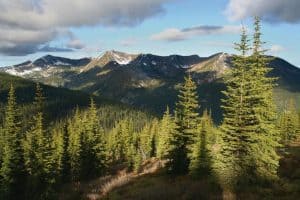
Salmo-Priest Wilderness, Colville National Forest.

The Colville National Forest released a draft Record of Decision for its revised forest plan on September 8. During the planning process, a collaborative group, the Northeast Washington Forestry Coalition submitted a proposal to designate more than 200,000 acres of new wilderness, to be offset by increased logging on other parts of the Forest and building new trails for mountain bikers, motorcyclists and ATV riders, who would lose access to some trails if Congress approved new wilderness. The revised plan proposed by the Forest includes only 60,000 acres of wilderness recommendations.

I guess that’s good news if you think that local collaboratives have too much influence on national forest decisions and/or if you are a proponent of logging. But wait!  It turns out that the most influence was wielded by the local governments, and the local timber company isn’t happy about that.

Russ Vaagen, vice president of Vaagen Brothers Lumber Co. and NEWFC board president, formally objected to the draft plan in a Nov. 6 letter. In the letter, he said the Forest Service’s decision was “skewed” by special interest groups. “The Colville National Forest belongs to all citizens of Washington and the United States,” he wrote. “Ferry, Stevens and Pend Oreille county commissioners represent just a tiny fraction of these citizens.” Later in the letter he said it’s unavoidable that locals will have “personal, financial interests” in what happens to federal land, but that those interests should “have no bearing on federal land management issues.”

This sort of left my head spinning. Maybe it’s because they didn’t get the increased logging either (I don’t know if that’s true)? Or maybe it’s that the “collaborative” part should win out over merely “local.” Or did the “local” actually use an end-run to obtain a top-down approach from an administration hostile to new wilderness?

I’ll go out on a limb here and suggest that since decisions to designate wilderness are inherently and legally political, this may legitimize and enhance the value of a local collaborative approach. Of course all is not lost on the Colville; the collaborative approach could count for something when the collaborative makes an end-run around the Forest Service to obtain wilderness legislation, since it can undercut an agency position that the Forest Service is doing what the public wants.

In another wilderness squabble involving an end-run by local governments to reduce wilderness protection, three counties in Wyoming have chosen to bypass a statewide collaborative process and support federal legislation that would eliminate wilderness study areas without designating any new wilderness.

Titled the “Restoring Public Input and Access to Public Lands Act of 2018,” HR 6939 would remove wilderness study designation and associated protections from approximately 400,000 federal acres in Lincoln, Big Horn and Sweetwater counties (see the bill below). The three counties declined to participate in a years-long consensus-based investigation of the wildlands. Saying the wilderness-study designation “prevents access, locks up land and resources, restricts grazing rights, and hinders good rangeland and resource management,” Cheney introduced her measure Sept. 27. It marked the third time she bypassed the Wyoming Public Lands Initiative sponsored by the Wyoming County Commissioners Association. Across the state, 777,766 acres of BLM and Forest Service property are protected by wilderness study designation. WPLI sought a single statewide wilderness bill to resolve study-area status. A majority of commissioners in the three counties, however, responded to Cheney’s early 2018 call for legislation before the WPLI process played out.

I’m cheering for the collaboratives here, too.

Pacific northwest collaboratives

This article is about the fact that the Malheur National Forest hasn’t had a lawsuit in 15 years.

Hannibal said “three to four times the amount of work” is getting done nowadays compared to 15 years ago. Timber sales data from the Malheur National Forest tell a similar story. From 2010 to 2016, the volume of timber cut from the forest more than doubled. The collaboration and a 10-year stewardship contract gets credit for saving the last sawmill in Grant County, Oregon, too.

It also links to the “Collaborative Directory” for the Pacific Northwest Region.

Every national forest in the Pacific Northwest has now aligned with at least one outside “collaborative,” as they are called. The idea is to build trust and get compromises done at the front end of proposed timber sales, thinnings or controlled burns. That way, the work doesn’t get bogged down in litigation or analysis paralysis later.

Forest Service directory lists 36 collaboratives associated with the 16 national forests in Oregon and Washington state. Some are more successful than others. Brown said the greater presence of endangered species west of the Cascades complicates the work of the groups active in wet-side forests.

It’s interesting to see how many groups are working where, but I just want to highlight that last point.  It suggests to me that addressing at-risk species is the key to successful projects, and that forest plans can and should provide the framework for doing so.  It would be nice to see revised forest plans treat this as an important issue and consider alternative approaches in that context.  On the other hand, there are no references to any forest plans or forest planning (as opposed to project plans and planning) in this document.  What am I missing?

Greater sage-grouse amendment amendment

Three years ago the Forest Service had this to say about the greater sage-grouse:

Two US Forest Service Records of Decision and associated land management plan amendments are the culmination of an unprecedented planning effort in cooperation with the Bureau of Land Management to conserve greater sage-grouse and its habitat on National Forest System lands and Bureau of Land Management-administered lands.

Last week it was this (and they initiated a public comment period):

Since approving the plan amendments in 2015, the Forest Service has gathered information and determined that the conservation benefits of Forest Service plans in Nevada and other states can be improved. That is, through repeated scoping, close collaboration with state and other federal agencies, and internal review, the Forest Service has identified proposed changes in the text of the greater sage-grouse plan amendments which would improve their clarity and efficiency and better align them with the Bureau of Land Management and state plans.

Specifically, the Preferred Alternative makes modifications to land management plans within the issue areas of: Habitat management area designation, including designating sagebrush focal areas as Priority Habitat Management Areas compensatory mitigation and net conservation gain; minerals plan components and waivers; exceptions and modifications; desired conditions; livestock grazing guidelines; adaptive management; treatment of invasive species; and changes to clarify text and eliminate errors and redundancies.

Oddly, it sounds like all of the new information must say that sage-grouse are doing better than we thought three years ago and/or they are less vulnerable to oil and gas drilling than we thought three years ago. The most important change in forest plans is probably this one (from an AP article):

The Obama administration created three protection levels for sage grouse. Most protective were Sagebrush Focal Areas, followed by Primary Habitat Management Areas and then General Habitat Management Areas. The Forest Service plan reclassifies the 1,400 square miles (3,600 kilometers) of Sagebrush Focal Areas as primary habitat.

The focal areas allowed no exceptions for surface development, while primary habitat allowed for limited exceptions with the agreed consent of various federal and state agencies. Under the new plan, the cooperation of states and some federal agencies to exceptions in primary habitat will no longer be needed for some activities but can be made unilaterally by an “authorized officer,” likely an Interior Department worker. That appears to be an avenue for opening focal areas to natural gas and oil drilling.

This amendment decision will be subject to the 2012 Planning Rule requirements for species viability and species of conservation concern (SCC) (from the DEIS):

… the FS is considering the effect on the greater sage-grouse as a potential SCC for each LMP that would be amended by this decision. The analysis in this DEIS shows that the amendments maintain ecological conditions necessary for a viable population of greater sage-grouse in the plan area for each LMP to which the amendments would apply.

Recall that the current conservation strategy was “generally viewed as keeping the bird from being listed for federal protections under the Endangered Species Act.”  What will the Zinke that is charge of the Fish and Wildlife Service have to say to the Zinke that is in charge of the BLM (and apparently the Forest Service)? Why does this remind me of political appointee Julie McDonald’s interference with decisions about lynx? Is it more about a new boss than about new science?  “A federal lawsuit is likely.”

Some more background is provided here.

Coastal pine marten proposed for listing as a threatened species

The U. S. Fish and Wildlife Service has proposed listing the coastal (Humboldt) marten, found in older forests in California and Oregon, as a threatened species.

“Martens are vulnerable to predation and increased competition in habitats that have been subject to either high–moderate severity fires or intensive logging in the last 40 years because both of these events remove the structural characteristics of the landscape that provide escape cover and are important to marten viability (canopy cover, shrub cover, etc.). These older forests have declined substantially from historical amounts…”

As a threatened species, the prohibitions in ESA against incidental take (§9) would not apply, but the FWS usually applies them using a special §4(d) regulation, which it is doing here. As is also common, they carve out exceptions to the prohibitions where take of the marten would be allowed; two of which would be relevant to national forest management:

(1) Forestry management activities for the purposes of reducing the risk or severity of wildfire, such as fuels reduction projects, fire breaks, and wildfire firefighting activities.

(3) Forestry management activities consistent with the conservation needs of the coastal marten. These include activities consistent with formal approved conservation plans or strategies, such as Federal or State plans and documents that include coastal marten conservation prescriptions or compliance, and for which the Service has determined that meeting such plans or strategies, or portions thereof, would be consistent with this proposed rule.

Here is the rationale:

“Although these management activities may result in some minimal level of harm or temporary disturbance to the coastal marten, overall, these activities benefit the subspecies by contributing to conservation and recovery. With adherence to the limitations described in the preceding paragraphs, these activities will have a net beneficial effect on the species by encouraging active forest management that creates and maintains the complex tree and shrub conditions needed to support the persistence of marten populations, which is essential to the species’ long-term viability and conservation.”

What this means is that forestry management activities that are not for the purpose of limiting fire or not consistent with the species’ needs would violate ESA if they harm any martens (unless they obtain an incidental take permit).

Regarding (1), I would ask whether all it takes to comply is for a project to say that it is for this purpose, or considering some of the discussions on this blog, does there have to be scientific support for the idea that a particular practice would actually have the intended effect.

Regarding (3), there is obviously a role for forest plans to include coastal marten conservation prescriptions. Presumably, plan components to create and maintain complex tree and shrub conditions for martens would be consistent with the NFMA requirement to provide ecological integrity and conditions needed for viability of at-risk species. What I haven’t seen before is a process by which the FWS reviews a forest plan for consistency with §4(d) criteria for a threatened species.

There could be future challenges to projects for violation of §9 because they do not meet these criteria.  The Center for Biological Diversity believes that “industrial logging” could meet these criteria and continue to occur in marten habitat.  At least (1) seems like it could be an exception that swallows the rule.  If it were dropped for fuel reduction projects, they could still occur if consistent with marten conservation under (3).

Gila plan revision’s “most divisive issues”

This is an account of a series of meetings that seems like a useful step in the forest planning process that I don’t think I’ve seen before:

Over the last year, the Forest’s planning team has held dozens of public meetings regarding the ongoing revision process. Through those, and other submission options, they have collected hundreds of comments on various aspects of the Gila’s management. Heather Bergman, of Peak Facilitator Group, called this round of meetings the “last call for ideas,” at Tuesday’s meeting in Reserve. Throughout the meetings, Bergman — whose company the Forest Service contracted to consult on the plan revision process — and Gila planner Matt Schultz showed attendees the range of opinions the team had gathered on each of the most divisive issues to that point.

These might be the same thing as “significant issues” under NEPA that warrant development of alternatives.  Here they are:

  • Livestock grazing management (“permittee should decide how resources are managed on their allotment” vs. “more restrictions placed on permittees” or eliminate grazing)
  • Land adjustments (“less public land” vs. “acquire desirable lands”)
  • Wilderness (delist some wilderness vs. significantly expand wilderness)
  • Riparian area management, restoration tools and “a few more”

Here’s what the facilitator took home:

“It is really amazing when you think about all of the different things the Forest Service manages on the Gila, these are the only things there is controversy on,” Bergman said. “There is a great deal of consensus on management, which is really nice.”

Lucky them!  Wildlife apparently didn’t make this list, which is not uncommon, even in places where it is a source of controversy, which is most places.  Maybe that’s because it is the underlying reason for other divisive issues like livestock grazing and riparian management.  (Maybe fire management is included under “restoration tools?”)

“Land adjustments” is not usually on this list, but at least on the Gila (home of Catron County) it looks like forest planning is seen as an opportunity to bring up privatization again.

Forest Service promotes wildlife overpass

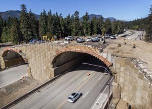
Despite a national effort (see pp. 29-30) to encourage it, and requirements in the 2012 Planning Rule to provide wildlife habitat connectivity, the Forest Service doesn’t seem to like to assert itself much in cross-boundary planning for such connectivity.  Here is a big exception, which should be an example of what can be done – and what should be done where the Forest Service is responsible for improving conditions for at-risk species.

By revamping the highway with wildlife’s needs in mind, officials were able to broker an easement with the U.S. Forest Service to add the additional lanes.

“It’s a win-win. We could improve transportation. We did lose some national forest,” said Garvey-Darda referring to construction of additional highway lanes. “But we can connect the North Cascades and the South Cascades.”

More importantly, I was told that the forest plan provided the basis for the Forest Service position in the negotiations that the North Cascades and South Cascades should be connected.  I can’t find language in the current plan that would clearly address this, but I know the plan revision process was moving towards useful language for connectivity.  Other revised plans are including language that at least provides some intent to participate in highway planning.  This is from the recently revised Kootenai National Forest Plan:

FW-DC-WL-17. Forest management contributes to wildlife movement within and between national
forest parcels. Movement between those parcels separated by other ownerships is facilitated by
management of the NFS portions of linkage areas identified through interagency coordination.
Federal ownership is consolidated at these approach areas to highway and road crossings to facilitate wildlife movement.

This would at least tell a Forest it needs to be a player and give them some leverage.  However, for at-risk species its role is to be a leader, and with nothing more than a desired condition and without identifying any linkage areas in the plan this would not meet any substantive requirements of ESA or NFMA (recovery or viability).  (Similar language in the uniform plan amendment for lynx does apply to mapped linkage areas.)


Zoning in the WUI

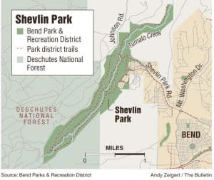
Another example of someone doing something right.  But it’s not the Forest Service; the Deschutes National Forest was listed as an agency that “either had no comment or did not respond to the notice.”  (The forest plan management area for much of the adjacent national forest is something called “other ownership,” but I couldn’t find what that means.)

Developers said they’ll cap the number of homes in the new zone at no more than 187 units — 100 on the north property and 87 on the south. Lots would all be designed to prevent risks of wildfire spreading and protect wildlife habitat, said Myles Conway, an attorney for Rio Lobo investments. Plans also call for a 42-acre wildlife conservation area adjacent to Shevlin Park.

The environmental watchdog group Central Oregon LandWatch, which fought to keep Bend’s urban growth boundary from encompassing the affected areas, “strongly supports” the so-called transect zone, LandWatch staff attorney Carol Macbeth said.

“It’s critical to take a new approach to development in the wildland-urban interface, and the Westside Transect is that approach,” Macbeth said. “It will provide a 4.5-mile first line of defense against approaching fires for developments like Awbrey Glen as fires approach from the west and northwest.”

Forest Service: We need more fires

An article in the Missoulian yesterday discussed “Toward Shared Stewardship Across Landscapes: An Outcome-based Investment Strategy,” a new Forest Service initiative that “rethinks the agency’s approach to wildfire, invasive species, drought and disease.”  It seeks a more coordinated and broader-scale approach with the states.  It seems to focus mostly on “systems that evolved with frequent fire.”

“Pre-settlement, 20 percent of California was on fire every year,” Phipps said. “That’s the scale of the problem. Lots of communities are doing wildfire protection planning, but they’ve been looking at, on average, 50 times less than the large landscapes we need to be concerned about.

“This is not about pruning trees,” Phipps continued. “Today, on average we’re treating about 1 to 2 percent of the area we need. We need to create conditions where 30 to 40 percent of that area can be treated with low-intensity ground fire before we get a significant reduction of risk.”

Rawlings also acknowledged that prescribed burning was a more inexpensive way of treating the forest than harvesting. And according to Forest Service research, more burning must happen for even productive timber land to stay healthy. Examinations of last year’s Rice Ridge and Lolo Peak fires near Missoula showed that even heavily logged timber stands had little effect on the big fires’ progress. But past burn scars and prescribed burn areas did slow or redirect the fires.

“We know in these fire-adapted systems, there’s no substitute for fire,” Phipps said. “Even in areas where there’s commercial value, if we want to reduce the fuel density of forests, we still have to bring fire back.”

That raises several challenges. The first is how to reshape public opinion about the need for fire. That means getting people used to having smoky air in the spring and fall, when prescribed burns can take place under safer conditions and release up to 10 times less toxic pollutants than mid-summer megafires.

“Prior planning opens up possibilities for us,” Phipps said. “In a year like this year, it’s not a good strategy to take risks and allow fire to roam on initial attack. But two or three years out of 10, we can allow fire to roam.”

“We need to mutually agree where the best places for investment are,” French said. “The way to get ahead of this is mutual, collaborative, cooperative work across the communities affected. We can’t do it alone.”

It looks like they missed an opportunity to promote the relevance of forest planning to making the strategic decisions about where we consider to be “fire-adapted systems” (or other areas) where active fuels management would be appropriate.

Some August FS court cases


The Forest Service recently won two lawsuits involving timber projects in Montana.

  • In Native Ecosystem Council v. Marten, the district court upheld the Telegraph Vegetation Project on the Helena Lewis and Clark National Forest.
  • In Native Ecosystem Council v. Erickson, it upheld the Smith Shields Forest Health Project on the Custer Gallatin National Forest.  One of the issues involved an amendment to the forest plan that modified standards applicable to elk habitat and old growth. In both cases, the court found that Forest was not arbitrary in concluding that the effects of the amendments were not significant and did not require an EIS.

In Sierra Club v. USFS, the 4th Circuit Court of Appeals ruled against the Jefferson National Forest for improperly amending its forest plan to create an exception to forest plan standards to allow the construction of the Mountain Valley Pipeline.  This was the first direct judicial test of the 2012 Planning Rule, but it was actually a test of a 2016 amendment to the Planning Rule that governs the application of the 2012 Rule to forest plan amendments.

That addition to the Planning Rule said:  Forest Service “shall . . . [d]etermine which specific substantive requirement(s) within §§ 219.8 through 219.11 are directly related to the plan direction being added, modified, or removed by the amendment,” and then “apply such requirement(s) within the scope and scale of the amendment,” and an agency’s “determination must be based on the purpose for the amendment and the effects (beneficial or adverse) of the amendment,” 36 C.F.R. § 219.13(b)(5).  The Preamble to the 2016 changes said, “When a specific substantive requirement is associated with either the purpose for the amendment or the effects (beneficial or adverse) of the amendment, the responsible official must apply that requirement to the amendment.

The Forest Service said that because the pipeline project would mitigate effects on soil and riparian resources they would not be “substantial,” and therefore the Forest did not apply the requirements of the 2012 Planning Rule related to soil and water resources, including “the ecological integrity of riparian areas” (36 C.F.R. § 219.8(a)(3)(i)).  The court held that, “the clear purpose of the amendment is to lessen requirements protecting soil and riparian resources, so the amendment was directly related to these requirements, and the Forest must apply the applicable Planning Rule requirements. It also held that the Forest had not adequately analyzed the effects of the pipeline on soil and riparian areas. The court remanded the amendment to the Forest “for proper application of the Planning Rule soil and riparian requirements to the Forest Plan amendment.”