Forest plan contributes to recovery of the lesser long-nosed bat

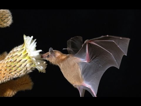
This cave-roosting nectar-feeding bat was listed as endangered in 1988, and has just been delisted.   According to the U. S. Fish and Wildlife Service:

The primary concern regarding future viability of this subspecies continues to be roost site disturbance or loss. This is primarily an issue related to human activities and destructive actions at these roost sites.

One of the three recovery criteria is “Protect Roost and Forage Plant Habitats.”  In its final delisting rule, the FWS cites the recently revised Coronado National Forest Plan as an existing regulatory mechanism that would protect the species (one of the 5 factors to be considered in listing a species, and a key one for this species):

More than 75 percent of the range of this species in the United States is on federally managed lands and these federal agencies have guidelines and requirements in place to protect lesser long-nosed bats and their habitats, particularly roost sites… If the lesser long-nosed bat is delisted, protection of their roost sites and forage resources will continue on Federal lands because agency land-use plans and general management plans contain objectives to protect cave resources and restrict access to abandoned mines, both of which can be enforced by law enforcement officers. In addition, guidelines in these plans for grazing, recreation, off-road use, fire, etc., will continue to prevent or minimize impacts to lesser long-nosed bat forage resources. The Coronado National Forest’s 2017 Land and Resource Management Plan (LRMP) includes standards and guidelines to retain and enhance areas with paniculate agaves in order to benefit the lesser long-nosed bat.

Federal land management plans directly address the main threats to the species, providing assurance that improving trends in population numbers would continue, and allowing delisting to be warranted.  Recovery of listed species should be an important goal for plan components in revisions of the rest of the national forest plans.  (Even where the value of a species is not as obvious as being “vital to the tequila industry.”)

Huron-Manistee forest plan contributes to recovery of the Kirtland’s warbler

The U. S. Fish and Wildlife Service has proposed removing the Kirtland’s warbler from the list of endangered species.  It inhabits young stands of jack pine in the Great Lakes region and was one of the first species listed in 1967 due to fire suppression and parasitic cowbirds.  More background from the FWS is here.

The 2006 Huron-Manistee forest plan includes many plan components designed to promote the species’ recovery.  One management area includes 7 areas identified as essential Kirtland’s warbler habitat or emphasis areas.  In these areas, among other things, the forest plan prohibits grazing, trail construction, and common variety minerals mining, and there are breeding season restrictions on recreation.

The forest plan also says:

A considerable portion of the dry sand outwash plains on the Huron National Forest in Management Area 4.2 will be managed as essential habitat for the Kirtland’s warbler… This prescription area contains approximately 45 percent of all National Forest System lands on the Huron-Manistee National Forests, which includes approximately 136,000 acres of Kirtland’s warbler emphasis areas.

Objectives:

Create approximately 1,600 acres of essential breeding habitat each year. Approximately 15,960 acres of essential breeding habitat will be available at any one time into the foreseeable future. This will enable the Forests to provide for a minimum of 420 pairs of Kirtland’s warblers.

Forest-wide standards and guidelines:

Habitat and population objectives are in accordance with the Kirtland’s Warbler Recovery Plan (USDI-Fish and Wildlife Service 1985) and Strategy for Kirtland’s Warbler Habitat Management (USDA-Forest Service 2001)

Management area standards and guidelines:

  • Develop Kirtland’s warbler breeding habitat by designing and configuring treatment blocks that mimic the regeneration effects of wildfire.
  • Prepare treatment blocks for regeneration by clearcutting.
  • Treatment blocks will be no greater than 550 acres unless reviewed by the Regional Forester.
  • Provide 15 to 25 snags per acre in treatment blocks.

By specifically incorporating science-based conservation and recovery strategies into the forest plan, the plan has guided the projects that have promoted recovery, and has limited activities with adverse effects.  The forest plan may also serve as a regulatory mechanism that the FWS can cite supporting its future outlook for the species.  This is a good example of what the 2012 Planning Rule directs forest plans to do.  (It’s too bad that Forest Service is less enthusiastic about including conservation strategies that restrict timber harvest.)


Coastal pine marten trending toward extinction on national forests

The coastal marten is at a high risk for extinction in Oregon and northern California in the next 30 years due to threats from human activities, according to a new study.

“The study, published today in the online journal PeerJ, will be available to federal and state wildlife agencies for their consideration to determine whether distinct geographic population segments of the coastal marten warrant state or federal listing as threatened or endangered, said Katie Moriarty, a certified wildlife biologist and lead co-author on the study.

Their population assessment revealed that the central Oregon population of coastal martens is likely fewer than 87 adults divided into two subpopulations separated by the Umpqua River. Using a population viability analysis, they concluded that the extinction risk for a subpopulation of 30 martens ranged from 32 percent to 99 percent.

In the short term, limiting human-caused deaths of the coastal martens would have the greatest impact on the animal’s survival, said Moriarty, who has studied the animals for several years. In the long term, the species requires more habitat, which perhaps could be accomplished by making the adjacent federal land in Siuslaw National Forest suitable for martens.”

So this isn’t just new information for use in the ESA listing process, but it also raises new questions about whether existing forest plans would provide conditions needed for viable populations.  I look forward to seeing how the Forest Service answers this question.  (And yes, the Forest Service does have the authority to limit trapping.)

Wild and scenic river plan lawsuit

The Wild and Scenic Rivers Act requires a comprehensive river management plan for eight rivers and creeks in southern California that Congress designated under the Act in 2009.  The law requires completion of river plans within three years of designation.  The rivers flow through national forest and BLM lands.  A complaint was filed March 27.

The North Fork of the San Jacinto River, for example, runs through lands managed by the San Bernardino National Forest and provides habitat for the critically endangered mountain yellow-legged frog, as well as other animals including California spotted owls and rubber boas.

Animals that live along Palm Canyon Creek include the southwestern willow flycatcher and Peninsular bighorn sheep.  “We’re concerned that by not having a comprehensive management plan for this wild creek that the resources could degrade over time,” she said.

The complaint asks  for “a permanent injunction, to prepare a Management Plan … by a date certain.”  Seems like a good candidate for a settlement, no?

Forest planning opportunities: Nantahala-Pisgah, Gila, Wayne

The Nantahala-Pisgah is expected to release its draft EIS and draft revised plan this summer.  “MountainTrue and the Nantahala-Pisgah Forest Partnership will host expert panels on the future of the Nantahala and Pisgah national forests” at four locations this month “to keep folks engaged and up to speed on the plan’s progress.”  “The Nantahala-Pisgah Forest Partnership was formed to bring all interest groups to the same table, including timber, water, wildlife, recreation, wilderness and more.”  There is no mention of the Forest Service participating (nor is it evident on the forest plan revision website).

The Gila has offered a “preliminary draft of a revised land and resource management plan” for public comments through April 23.  “Feedback received on this preliminary draft forest plan will be used as Gila staff revise the forest plan and analyze alternatives under the National Environmental Policy Act process.  Changes, sometimes significant ones, will occur throughout the document prior to being released as the official Draft Plan later in the year.”  This is an additional opportunity to participate beyond the usual NEPA review periods.

The Wayne is hosting meetings to discuss the forest plan revision process it has just begun.  “The format of these meetings will be an open house in which staff from the Wayne National Forest will be available to explain the revision process and answer questions the public may have,” said Forest Supervisor Tony Scardina.  “It is also important for the public to understand that these initial meetings and webinars are not intended to discuss or address specific topics. That will come at a later time in the process and we look forward to hearing at these meetings how people would like to be engaged over the next several years.” (At least they are not downplaying the timeline.)  For those who can’t attend meetings in person, there will be web-based meetings in April!!

Cherokee National Forest objects to objection

Plaintiff environmental groups expressed concerns from the beginning of the Dinkey Project about the effects on water quality because of erosion caused by previous nearby timber projects in similar terrain.  After the Forest released the draft EA on the Project it also released a monitoring and evaluation report that revealed the erosion problems caused by the earlier projects and included recommended mitigation measures.  The EA and Decision Notice for the Dinkey Project failed to acknowledge this information and relied on mitigation measures that had failed in the earlier projects.  The complaint alleges violations of NEPA and also NFMA because the Project would be inconsistent with the forest plan requirements for soil protection and would cause irreversible resource damage.

The plaintiffs also filed an administrative objection to the Dinkey Project raising these concerns.  The Forest Service dismissed the objection, citing failure to comply with the requirements for objections as follows:

“Based on the information provided in your objection, the issues raised do not demonstrate connection to prior comments with specific violations of law, regulation, or policy. In addition, no specific proposed remedies are stated for consideration by the Reviewing Officer for resolving the objection. Therefore, the objection does not comply with 36 CFR 218.8(d)(5) and (6).”

Here are those requirements:

(5) A description of those aspects of the proposed project addressed by the objection, including specific issues related to the proposed project; if applicable, how the objector believes the environmental analysis or draft decision specifically violates law, regulation, or policy; suggested remedies that would resolve the objection; supporting reasons for the reviewing officer to consider; and

(6) A statement that demonstrates the connection between prior specific written comments on the particular proposed project or activity and the content of the objection, unless the objection concerns an issue that arose after the designated opportunity(ies) for comment (see paragraph (c) of this section).

The complaint describes how plaintiffs have met these requirements.  In my experience, it is unusual for the Forest Service to nitpick an objection like this, especially in a case where the parties have consistently described what their concerns are and what they would like the agency to do.  It’s certainly not consistent with the idea that pre-decisional objections are more collaborative than post-decisional appeals.  Is this a unique situation or is it a manifestation of Trump Administration policies to get rid of barriers to “getting the cut out” (again, “GTCOA”)?

National monument planning on a fast track

The BLM will hold four scoping meetings the week of March 26  to identify key issues and planning criteria for two environmental impact statements (EIS) for the Bears Ears and Grand Staircase-Escalante national monuments, “but monument supporters say the BLM should holster its planning process until the courts resolve lawsuits seeking the monuments’ restoration…  Culver and other critics fear Interior is rushing to get lands holding fossil-fuel deposits back under lease to private industry quickly, before the courts have a chance to revoke Trump’s action and put the minerals off limits again…  Those deposits were reopened to mineral entry beginning Feb. 2, but BLM officials say they cannot be leased for development until a new management plan is in place for the 862,000 acres removed from the monument.”

So there is a planning process for lands removed from the GSE monument that were discussed here.  A new plan might authorize the chaining project that would be prohibited by the current plan, but it seems premature for the BLM to be developing that project assuming the plan would be changed to allow it.

BLM O&C plan changes may lead to ESA listing

One of the factors considered in listing a species under ESA is the adequacy of exiting regulatory mechanisms.  One of the biggest payoffs from national forest and BLM planning may be the adoption of such mandatory mechanisms that would protect a species and reduce or eliminate the need to list it under ESA.

The Northwest Forest Plan included a requirement to survey for rare species prior to logging projects – “Survey and Manage.” BLM amended its Northwestern and Coastal Oregon Resource Management Plan in August 2016 (see prior discussion on this blog here).  One significant change in the approach to managing at-risk species was eliminating the Survey and Manage requirement.  Here is the statement regarding this change from the BLM:

“The Proposed RMP, like the action alternatives, does not include the Survey and Manage measures of the No Action alternative. The Survey and Manage measures were included in the Northwest Forest Plan to respond to a goal of ensuring viable, well-distributed populations of all species associated with late-successional and old-growth forests. This goal of the Northwest Forest Plan was founded on a U.S. Forest Service organic statute and planning regulation, which did not and do not apply to the BLM, and is not a part of the purpose for this RMP revision. As detailed in the analysis in the Proposed RMP/Final EIS, the Proposed RMP will allocate a larger Late-Successional Reserve network than the No Action alternative, will protect older and more structurally-complex forests, and will continue to provide management for many of the formerly Survey and Manage species as Bureau Sensitive species. The Proposed RMP can achieve the purpose of this RMP revision and respond the BLM’s statutory authorities and mandates without the Survey and Manage measures.”

Here is a response:

Conservation groups Monday petitioned the government to list the rare Siskiyou Mountains salamander under the federal Endangered Species Act, claiming federal land managers’ apparent reneging on old “look before you log” provisions in potential future logging sales imperil the rare forest amphibian.

Since 2007, the BLM has been required to survey for rare species like the Siskiyou Mountains salamander and manage 110 high-priority sites for the benefits of salamanders and their habitats. This survey-and-management plan, was also known as the “look before you log” approach, generally includes logging buffers should sales move forward.

Conservation groups originally filed for Endangered Species Act protection for the salamander in 2004. The 2007 conservation agreement, as well as old-growth forest protections under the Northwest Forest Plan, were cited by the Fish and Wildlife Service when it denied Endangered Species Act protection for the salamander.

The Fish and Wildlife Service will now have to consider the effect of the changes in the BLM plan, and may decide that listing this species is warranted.  That could lead to further restrictions on logging.  Of course BLM could then blame someone else – for forcing it to recognize that protecting species and ecosystems is part of its mission.


Bears lose to cows

Here is George Wuerthner’s take on livestock allotment planning on the Bridger-Teton National Forest.

The Upper Green Allotment is the largest Forest Service grazing allotment in the West. It is a mixture of aspen, rolling sagebrush/grassland, willow-lined creeks, intermixed with ponds, and springs.

It contains the best wildlife habitat outside of a national park. Home to grizzlies and wolves, endangered Colorado cutthroat trout, sage grouse, elk, moose, pronghorn, and various rare amphibians, among other outstanding wildlife values.

That is one reason why the BTNF Forest Plan has categorized 93% of the area as DFC 10 and 12 status where protecting wildlife values is the primary goal. Yet the FS manages it as more or less a feedlot for a few local ranchers.

Since 1995, 34 grizzly bears have been “removed” from the Upper Green River allotment. When I questioned why the public’s wildlife was being removed instead of private livestock using our public lands, I was shut down and told I wasn’t allowed to debate these issues.

According to the Forest Service,

The purpose of the project is to continue to authorize livestock grazing in a manner that will maintain
or improve resource conditions. The Bridger-Teton Land and Resource Management Plan … provides direction to support community prosperity in part through livestock grazing (Goal 1.1 and Objective 1.1(h),… in a manner that avoids unacceptable effects from livestock use on range, soils, water, wildlife, and recreation values or experiences …

The majority of the project area is in DFC 10 (approximately 66 percent). The area theme is an area managed “to allow for some resource development and roads while having no adverse, and some beneficial effects on wildlife.”  The management emphasis is to “[p]rovide long-term and short-term habitat to meet the needs of wildlife managed in balance with timber harvest, grazing, and minerals development.”

Grizzly bear management objective is to minimize the livestock related grizzly bear mortality.

All of the alternatives would permit more cattle to graze than has historically occurred (Table ES-2).  All of the alternatives would be likely to adversely affect grizzly bears, which also sounds like a conflict with the forest plan requiring management for no adverse effects.  Arguably, a “no grazing” alternative would not meet the purpose and need, but it looks to me like they haven’t considered a reasonable range of alternatives to reduce impacts on grizzly bears.

He’s got some interesting comments about the bias of range “cons” who “deferred to the ranchers:”  “I can also assure you that most range cons are “want to be” ranchers…”  My experience was that they were more likely to be “want to be” wildlife biologists.  In contrast my experience with foresters (other than myself) is that they like to manage forests, and “no-action” has never appealed to them much, maybe because “it would result in no reason for your position.”

Is a subdivision surrounded by national forest “reasonable?”


ANILCA provides: “Notwithstanding any other provision of law, and subject to such terms and conditions as the Secretary of Agriculture may prescribe, the Secretary shall provide such access to nonfederally owned land within the boundaries of the National Forest System as the Secretary deems adequate to secure to the owner the reasonable use and enjoyment thereof: Provided, That such owner comply with the rules and regulations applicable to ingress and egress to or from the National Forest System.” 16 U.S.C. § 3210(a)

“The U.S. Forest Service is currently considering approval of a new two-lane paved road across public lands north of Edwards to facilitate development of Berlaimont Estates — 19 new mansions, 2,000 vertical feet above town. The sprawling subdivision would be developed on a parcel that is completely surrounded by National Forest.

Unlike other nearby neighborhoods (e.g., Wildridge and Mountain Star), public land managers must approve a new road across lands owned by you and me to facilitate this proposal. To approve the new road, the Forest Service must deem Berlaimont Estates a “reasonable” land use.”

How does the White River National Forest determine what is a reasonable use?  Dose it matter what the surrounding use of the national forest is?  Does it matter if it creates bigger WUI problems?  When you buy a piece of land surrounded by public lands with no access is it reasonable to expect to build a subdivision?

These questions are intertwined (and sometimes conflated) with the question of whether the “regulations applicable to ingress and egress” (access) are reasonable.  Should the Forest Service be able to say that the proposed “32-foot wide, bermed, walled, plowed and paved thoroughfare switchbacking thousands of feet up a very visible hillside,” where “the walls necessary to support this road could be more than 1,000 feet long and as tall as 40 feet” is not reasonable?  The Forest Service has been upheld when it limits the kind of access to inholdings.  And by the way, “The 2002 Forest Plan designated this area Deer and Elk Winter Range and restricted winter use to minimize disturbance.”  It seems like a road with lots of use on it might be inconsistent with the forest plan.

It’s probably unfortunate that the local land use plan either allows a subdivision here or there isn’t any local planning.  It is Forest Service policy to get involved with that process, in part to help it deal with these hard questions.