Fall forest planning news

Source: Glacier-Two Medicine Alliance

Not even a pandemic can stop forest planning.

Forest plan revisions for the Blue Mountains of eastern Oregon and Washington stalled again in March, 2019, when the Forest Service Washington Office responded to objections on the Umatilla, Malheur and Wallowa-Whitman revised forest plans by instructing the regional forester to withdraw the draft record of decision for “additional information.”  One of the reason given was, “The Revised Plans also did not fully account for the unique social and economic needs of local communities in the area.”  While not specifically citing these instructions, the Forest Service and the Eastern Oregon Counties Association have funded a research project that will help understand the impacts of forest management across the Blue Mountain region, including the potential impacts of new forest plans.  The Forest Service has always done social and economic analysis as part of forest planning, but according to Nils Christoffersen, director of Wallowa Resources …

“The desire was to create a system to get more localized analysis of what would be the impact of increasing or decreasing timber harvest on national forest land, (or) increasing or decreasing the grazing activities,” he said. “(It’s) trying to understand the relative economic importance of the national forest system land and their management to the economics of the Eastern Oregon counties.”

Blue Mountains revision page


The Manti-La Sal National Forest released a “draft forest plan” in October as part of its plan revision process.  The Forest cautions that they are not even to formal the scoping stage, which would initiate the EIS process, but they are looking for public comments on what I would characterize as a detailed proposed action.  They have scheduled several “virtual workshops” that address different plan revision topics.  (After today, one remains on “Watershed,” December 3.)  A coalition of conservation groups has already submitted a “conservation alternative” that, “emphasizes scientific data and recommends adapting forest use to climate change and population growth as well as prioritizing conservation of water, native species and ecosystems over commercial use, and pushing for greater inclusion of Indigenous groups in policy-making.”

Manti-La Sal revision page


In fiscal year 2020, the Nez Perce-Clearwater National Forest sold 84.5 million board feet of timber, the most since 1991.  An annual volume of 125-150 million board feet is included in the current draft of the revised forest plan.

Environmental groups are split over the uptick. Some, like Gary Macfarlane of the Moscow-based Friends of the Clearwater, say it is damaging water quality and habitat for salmon and steelhead. While others, like Brad Smith of the Idaho Conservation League, say current logging levels appear sustainable as long as the work is done with proper environmental review and robust public participation. The latter has participated in the Clearwater Collaborative, while the former hasn’t.

“If they maintain the current riparian buffers, if they don’t harvest old growth and they provide adequate wildlife habitat security, I think 125 million board feet (per year) is sustainable,” Smith said.

The Forest Service proudly proclaims,

“The more volume we produce, the more miles of roads we maintain, the more sediment we reduce and the more fish passage culverts we install — and the more wildlife habitat gets improved.”

A county commissioner has reservations about this, since the programs allowing the agency to reinvest proceeds of timber harvest into restoration cut the county out of its share.  (I have my own reservations about logging to raise money, especially if it is independent of ecological needs established in the forest plan, and how that is used in the NEPA process as discussed here.)

McFarlane doesn’t buy the agency’s contention that logging leads to improved environmental conditions.

“To conflate logging with restoration is one of the biggest hoaxes perpetrated on the American public,” he said. “There is no science that supports that — none.”

“They are always predicting an upward trend (in water quality) for all of the road decommissioning they are doing, but when they go back into the watershed (to monitor water quality) they are still not meeting forest plan objectives. That is why they want a new plan that removes those objectives.”

Nez Perce-Clearwater revision page


The Custer-Gallatin National Forest held its meeting with those who have objected to its final revised forest plan.  The issues revolve mostly around wilderness designations.  According to this article, most objectors argued the land designations proposed for these areas don’t sufficiently safeguard wildlife habitat from recreation-related fragmentation.  The objectors include the Gallatin Forest Partnership, which submitted its own set of recommendations for the plan to the Forest Service.  One of those recommendations for wilderness is supported by the Southwest Montana Mountain Bike Association.
Custer-Gallatin revision page


Forest plans and legislation – Blackfoot-Clearwater wilderness proposal

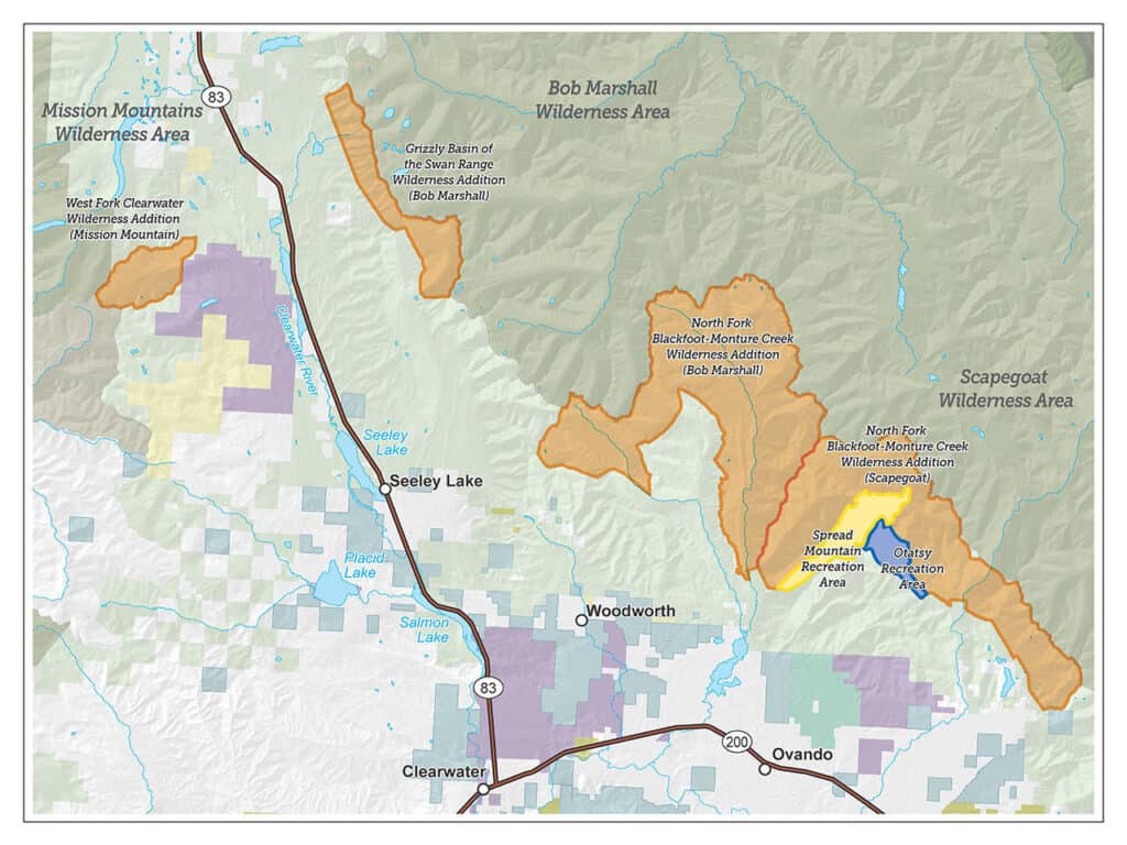
Blackfoot-Clearwater Stewardship Project map, Feb. 2018.

Wilderness designation has always been controversial in Montana.  No new wilderness areas have been established by Congress since I believe 1977, and unlike most states there has never been statewide wilderness legislation.  The Blackfoot-Clearwater proposal to designate 90,000 acres on the Lolo National Forest was locally developed and has been pending in Congress for several years.  Its development included addressing issues related to motorized and mechanized recreation that we have been discussing here, and designates areas for both.  This article provides some background, and includes a link to the written statement from the Forest Service regarding the proposed legislation.

The statement relates to forest planning in a couple of ways.  First, the Forest Service uses the Lolo National Forest forest plan as the foundation for its position on the legislation.

We also have concerns about implementing section 202, which establishes the Spread Mountain Recreation Area for the apparent purpose of enhancing mountain biking opportunities. The Lolo’s current land and resource management plan identifies this area as recommended wilderness. This area is characterized generally by steep topography, sensitive soils, and contains sensitive fish and wildlife habitat. Trail 166 is the main access into this area. This trail is not maintained, not passable by riders on horseback, and becomes difficult to locate after the first mile. While we acknowledge the interest in expanding opportunities for mountain biking on the Lolo, we are concerned that the site designated for the Spread Mountain Recreation Area is not well-suited for this use, and that this designation could create conflicts with wildlife and other recreation uses.

Two of the three wilderness designations in Title III are consistent with the recommendations made in the existing Lolo National Forest land and resource management plan. The third designation (West Fork Clearwater) was not recommended in the management plan to be Wilderness, it was allocated to be managed to optimize recovery of the Grizzly Bear.

One might argue that the 1986 forest plan is outdated, and recent local efforts should be given greater consideration.  However, those efforts have not been through any formal public process, so I commend the Forest Service for using its forest plan.  I’m not sure whether NFMA’s consistency requirement applies to taking positions on legislation, but it is probably the right place to start.  The proposal is also interesting in its legislative designation of two “recreation areas,” taking these decisions out of the forest planning process.

The Lolo is scheduled to begin its forest plan revision process in 2023, and the Forest Service is also concerned about the interaction between the revision process and this legislation.  It sounds like mostly a budgetary concern:

Our primary concerns pertain to Title II. Section 203 which would require the Forest Service to prepare a National Environmental Policy Act analysis for any collaboratively developed proposal to improve motorized and non-motorized recreational trail opportunities within the Ranger District within three years of receipt of the proposal… If passed in its current form, this bill could require recreation use allocation planning for site-specific portions of the Seeley Lake Ranger District ahead of the broader plan revision process, which would forestall the Lolo’s ability to broadly inform land use allocations across the forest through the plan revision process… If enacted, the explicit timeframes currently contained in the bill could result in prioritizing the analysis of a collaboratively developed proposal to expand the trail system over other emergent work.

But they might also be suggesting that the site-specific recreation planning would benefit from waiting until the forest plan is revised.  (Or maybe they just don’t like deadlines.)

Good news for wildlife on two national forests

Here are two different kinds of success stories about restoring wildlife species that have been missing from national forests.


Grizzly bears – Lolo National Forest.

Current efforts on the Lolo National Forest demonstrate one way that forest plans can improve conditions for at-risk species; in this case the plan is contributing to conservation of the federally threatened grizzly bear. Grizzly bears have been sighted in recent years in this part of the Forest, but none are females or considered to be residents.

In 2011, the forest plan was amended to include what is commonly referred to as the Access Amendment (similar amendments also applied to the Kootenai and Idaho Panhandle national forests, prior to the revision of their forest plans).  The amendment established “standards” for motorized road and trail density in grizzly bear management units (BMUs, there is one on the Lolo).  In many cases, the current conditions did not meet these standards, so in the terminology of the 2012 Planning Rule, these would be desired conditions or objectives to be achieved.  In addition, their achievement was assumed in the biological opinion on the effects of the forest plan on grizzly bears prepared by the Fish and Wildlife Service, and failure to achieve them would likely trigger the need to reinitiate consultation on the forest plan (which had happened on the Flathead National Forest).  So there is a little added incentive, but here is what they are doing now.

The Forest has completed the “BMU 22 Compliance Environmental Assessment.”  In it they have proposed to formally close some roads that are effectively closed already and 21 trail miles currently open to motorized use.  In response to public comments, they are also considering an alternative that would close fewer trails, and instead close some roads currently open to motorized use.  In addition to other closures included with some prior vegetation management projects both alternatives “would bring the Forest into compliance with the Forest Plan motorized access management standards for the Cabinet-Yaak grizzly bear recovery zone.”

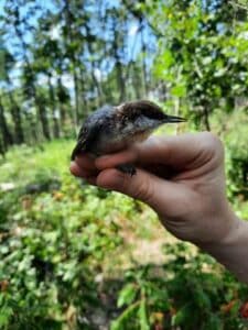
Brown-headed nuthatch – Mark Twain National Forest

The nuthatch is not at-risk range-wide, but they have not been found in Missouri for at least a century.  The species requires shortleaf pine and oak woodland forests, which have been greatly reduced from historic levels.  The loss of these forests has prompted an ecosystem restoration effort across Missouri, Arkansas and Oklahoma (notably using the Collaborative Forest Landscape Restoration Program).  Restoration of such forests is a desired outcome of the Mark Twain forest plan.  Curiously, there is no mention of the brown-headed nuthatch in the 2005 forest plan, although it does address other species using the same habitat:

Objective 1.4a Improve open woodland conditions on at least 10,500 acres to provide habitat for summer tanager, northern bobwhite, Bachman’s sparrow, and eastern red bat.

The EIS states that the nuthatch is a Management Indicator Species for forest plan monitoring, but that doesn’t seem to be in the plan itself.  Of course, a species that is absent from a national forest would not make a good MIS.  In any case, it looks like there was no interest by the Mark Twain in reestablishing a species that was not present on the forest under that rules applicable to forest planning in 2005.

However, Forest Service, state and university researchers came to the rescue of the species, determining that sufficient woodlands now exist in Missouri to support a population of Brown-headed Nuthatches, that populations in Arkansas were robust enough to supply birds to Missouri, but that nuthatches are not likely to make the return on their own because of the distance and habitat fragmentation.  The Mark Twain National Forest site was chosen for the release of 100 birds because it is the largest area of open pine woodlands in the state.

Under the 2012 Planning Rule, the Forest Service would probably argue that this species is not “known to occur” in the plan area, so the requirement to provide ecological conditions for it (as a species of conservation concern) would not apply.  However, the separate requirement for ecological integrity requires “species composition and diversity” to occur within the natural range of variation.  That should make the Forest Service more proactive in reestablishing species that historically occurred there.  (The forest plan also omits the listed red-cockaded woodpecker, which also uses these habitats, is also absent, but must be conserved and recovered.)

(For a look at how the natural range of variation might work under the 2012 Planning Rule see Table A-2, “Desired conditions for natural community types.”)

Stanislaus spotted owl plan amendment

Photo of female and juvenile California spotted owl courtesy of University of California Cooperative Extension (http://ucanr.org/sites/spottedowl/).

We recently looked at the Biological Assessment of Northwest Forests, and the options for proceeding with revising forest plans currently governed by the Northwest Forest Plan. Some of those options involved amendments to existing plans prior to plan revision. I voiced support for amendments that would provide the ecological conditions needed for at-risk species. I thought this might be an example to look at for how that might go.

The Stanislaus National Forest is not in the area covered by this assessment. Its forest plan was originally completed in 1991, but it was amended by the Sierra Nevada Forest Plan Amendment (or Framework) in 2004, which is roughly analogous to the Northwest Forest Plan in that it had its origins in the work done to protect the California spotted owl (it has its own complicated political and legal history). Now the Stanislaus is proposing an amendment for a part of the Forest in conjunction with what it calls the Social and Ecological Resilience Across the Landscape (SERAL) project.

The Forest has identified a need to change the forest plan based on new information about the California spotted owl, as published in 2019 by the Forest Service in the “Conservation Strategy for the California Spotted Owl in the Sierra Nevada.”

In order to fully adopt and implement the management direction described in the Conservation Strategy and increase landscape resiliency as guided by NRV the Stanislaus National Forest’s forest LRMP must be amended. The proposed forest plan amendments would allow the SERAL project’s proposed landscape restoration treatments to best meet the purpose and need of the project and implement the guiding principles of the 2019 California Spotted Owl Conservation Strategy. The proposed amendments include standards and guidelines which will provide some immediate stability for individual owls while allowing forest management the ability to conduct treatments designed to help develop resilient habitat conditions that provide CSO conservation in the long term.

Unfortunately, the CSO Conservation Strategy was apparently written for a narrower purpose than its name implies:

The California spotted owl (Strix occidentalis occidentalis) Conservation Strategy is a strategic framework for active conservation of the California spotted owl on National Forest System lands in the Sierra Nevada.

It appears to be something less than a scientific strategy. By limiting the focus to “active conservation” it has failed to address the central debate about managing spotted owl habitat regarding when active management should even be used. Passive management is one obvious alternative to this amendment that the Forest is going to have to address in its amendment process. But I looked at some of the proposed changes in the forest plan.

The current plan designates spotted owl Protected Activity Centers (PACs) as management areas in the forest plan (which could be changed only by amending the forest plan). This proposed amendment would replace current management areas with guidelines to designate PACs later “in advance of any management activities that would reduce CSO nesting and roosting habitat quality.” The guidelines include criteria for delineating and changing PAC boundaries.

My opinion: This is not a coarse filter management strategy based on vegetation because it depends on actual owl presence based on surveys, or one might call it “condition-based.”  If owl presence is the kind of thing that changes frequently, this may be a reason to not designate permanent management areas at the plan level.  However, this creates the risk of cutting the public out of the part of the process that actually determines the locations for management.  The plan is no longer saying, “here is where we’ll manage for owls,” but instead, “we’ll manage for owls where we think we need to manage for owls, trust us.”  The criteria must be explicit and objective enough to fully evaluate at the plan level, and the decisions about whether and how to apply them at the project level must include the public. Given the importance that surveying would take on, there is no excuse for these being guidelines rather than standards. It seems to me that the certainty of owl protection, and therefore the viability of the species, is going to be reduced.

There are a lot of new plan components in the amendment, and the CSO Conservation Strategy is page-referenced for most of them. That’s how any conservation strategy should be used, so maybe this is a good example of that. Except that it strikes me that this “conservation strategy” may have actually been written as a “drop-in” amendment to be used this way (which makes that kind of cross-referencing a lot easier). This is similar to what would happen if plan amendments were developed that could be later “dropped in” to forest plan revisions. The problem is that if the “conservation strategy” is already a management-influenced document and not a science document, there would still need to be a reference to the actual scientific basis for these conservation recommendations that are being adopted.

Anyway, this project/amendment will be worth watching as it applies the 2012 Planning Rule diversity requirements to California spotted owls. And it may be setting some precedents for what could happen regarding how to plan for management of spotted owl habitat on other national forests.

Modernizing Planning Discussion in R-6/R-5 Bioregional Assessment: Which Would You Pick and Why?

Many, many thanks to folks who write the RVCC newsletter for finding this in the voluminous Bioregional Assessment Steve posted here pp. 37-38.

This discussion touches on many topics that we talk about.

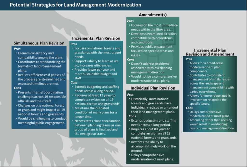
Simultaneous Plan Revision—All 19 forests and grasslands in the BioA area would complete plan revision at the same time. This approach, like the landscape-level approach used during the NWFP, would ensure consistency and compatibility among the plans and would contribute to standardizing the formats of land management plans to help develop a common understanding of management direction. Completing simultaneous plan modernization presents significant capacity and coordination challenges across 19 responsible officials and their staff; however, efficiencies might be realized if phases of the process are streamlined and expected timelines are met. If, during simultaneous plan updating, the required analyses are integrated and conditions change significantly on one national forest or grassland requiring different or additional analysis, all 19 units would likely be impacted. Finally, this strategy might present a challenge to meaningful engagement with the public in the planning process because of the amount and complexity of information and the breadth of the geographic scope.

Incremental Plan Revision—We would revise three to six land management plans at the same time based upon similar challenges and geography. As an example, we could start with five units in the southwestern BioA area based on growing departure in desired ecological conditions, vulnerability to fire cost and behavior, and dependency of local communities on benefits from national forests and grasslands. The planning effort on the next group of units would begin approximately 1 year before the process is complete on the first group, and so on until revisions for all 19 units are complete. This option would allow the Forest Service to focus on the units with the most urgent needs for modernization first and would support our ability to learn as we go, which will help us continually improve land management planning efficiencies. Budgeting and staffing needs would be extended across a longer period than under the simultaneous plan revision option but would be lower per year and therefore, potentially more sustainable. Under this approach it would take at least 12 years to complete revision on all 19 units and would maintain the outdated condition of many plans for a longer time. Ensuring consistency and compatibility between plans that are in different groups would require close coordination between planning teams as one group of plans is finalized and updating is started on the next group.

Amendment(s)—Under this option, we would complete a range-wide amendment of all or a subset the land management plans to address one or more of the topic areas identified as needing change in the BioA. For instance, this option could be used to develop up-front, standardized agreements on range-wide management for listed species such as the northern spotted owl. This method could specifically address issues like northern spotted owl habitat connectivity throughout its range and facilitate Engendered Species Act consultation on future plan revisions. Amendments could also be used to better align late-successional reserve boundaries with late-successional habitat. An amendment process, even at a large scale, would be shorter than full plan revisions, and might take only 2 years to complete. This approach would allow the Forest Service to focus on the most immediate needs within the BioA area and might be a more streamlined option for creating direction that is compatible with the various ecosystems and conditions. Opportunities for public engagement would be more focused on specific areas and issues, which might allow for more robust public involvement. A drawback to this approach is that it would not completely address the problems associated with overlapping management direction. In addition, while this approach would focus on the most urgent issues within the BioA area, it would not be a comprehensive modernization of all plans; plans would remain outdated and many important updates would not be completed.

Individual Forest Plan Revision—Historically, land management plans are revised or amended by individual national forests or grasslands. However, many of the ecological and socioeconomic conditions in the BioA area span many forests and grasslands and are therefore, best addressed at a landscape scale. Completing individual land management plan modernizations wouldn’t meet the agency’s goal of reducing the time and cost to produce efficient, effective, and high-quality land management plans to accomplish more work on the ground and be more responsive to our public.

Incremental Plan Revision and Amendment—We would begin modernization on a prioritized group of units, as in the incremental plan revision option, and simultaneously complete amendments on other units that are facing some of the same urgent issues. For instance, as a group of plans are updated to include refined and improved direction associated with the natural role of fire in frequent-fire dependent ecosystems, all other plans on units with similar ecosystems could be amended to incorporate the same language. This approach would allow for a broad-scale modernization of plan components to meet immediate needs without the complexity of updating many plans at the same time. The approach would contribute to consistent management of similar issues across the landscape as well as management that is compatible with the varied ecosystems. Potentially, this approach would contribute to more robust public involvement related to the specific issues on which amendments were focused. However, comprehensive modernization of most plans would still be delayed and amending plans rather than revising them would still result in overlapping layers of management direction.

Many of the identified opportunities for modernizing the land management plans in the BioA area cross multiple national forest and grassland boundaries. Some management opportunities on some national forests and grasslands are more urgent than others, while other
challenges experienced across several national forests and grasslands would benefit from a consistent approach. Some forests have a more urgent need for restoration activities to improve the resiliency of the landscape than others (figure 2-6). The need for management consistency arises when multiple national forests and grasslands face the same management challenge; an example is managing habitat to facilitate the recovery of the northern spotted owl across that species’ range (figure 2-7). We gain efficiencies by combining modernization efforts around similar management needs.

(In the document is this sidebar)

Combination approach—An Example
Relevant direction from the US Fish and Wildlife’s Conservation Strategy for Grizzly Bear in the Northern Continental Divide Ecosystem 2019 63 has been incorporated as amendments to the land management plans for the Helena, Kootenai, Lewis and Clark, and Lolo National Forests. The Flathead National Forest incorporated the relevant direction into its land management plan revision. This combination of revision and amendments ensures that habitat for this wide-ranging species is managed consistently and appropriately across all affected national forests.

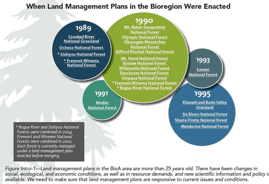
I wish they had specific examples of why there is an “urgent” need to change, that might help us compare the different approaches. How urgent is urgent and why? Anyway, which would you pick and why? And how did they manage to do so many in 1990?

It’s National Forest Week – so let’s think about forest planning for tribal areas

But we all knew that, right?  Here’s the National Forest Foundation link.

But here’s the rest of the story:

It’s National Forest Week, and members of the Crow Tribe are celebrating recognition of a special place in Montana.

In the U.S. Forest Service’s final draft of its Custer Gallatin National Forest plan released last week, the agency recognized the cultural and spiritual significance of the Crazy Mountains, designating it an “Area of Tribal Interest.”

The Custer Gallatin plan recognizes only the southern part of the Crazies. The Forest Service did not include the cultural significance of the northern part in its Helena-Lewis and Clark National Forest plan from May.

Ideally, Doyle (a Crow tribal member) said, the tribe would like to see both sections recognized, but he noted that the region in the Custer Gallatin National Forest is most significant.

Why?  If there was one thing that everyone involved in developing planning regulations agreed on, it was that management direction should not change just because of an administrative boundary with a different staff member in charge.  And now this.  Two adjacent forest plan revisions, on roughly the same schedule, and different ideas about what?  Maybe there’s some legitimate resource reasons, but here’s the extent of the plan components for this area (and they don’t require much):

Desired Conditions (BC-DC-TRIBAL)

01 The Crazy Mountains embody a tribal cultural landscape significant to ongoing traditional cultural practices of the Crow Tribe.

02 Research, education, and interpretation of the Crazy Mountain tribal cultural landscape provides public benefits and enhances the understanding and appreciation of Crazy Mountain’s natural environment, precontact, contact, and Crow traditional cultural values.

Goals (BC-GO-TRIBAL)

01 The Custer Gallatin National Forest protects and honors Crow treaty obligations, sacred land and traditional use in the Crazy Mountains through continued consultation with the Crow Tribe.

This is not the only “area of tribal interest” on the Custer-Gallatin.  The Helena-Lewis and Clark plan has plan components for “areas of tribal importance,” but does not identify them (other than the Badger-Two Medicine area).  The plan dedicates one descriptive sentence to the tribal history in the Crazy Mountains.  So, again, how does the Forest Service explain the line they have drawn here?

(Related to the consistency idea, there was a lot of debate about whether plan decisions should be made by forest supervisors or regional foresters.  The Forest Service went with the former (I was told so the Chief wouldn’t be involved in objections), and this is the kind of problem they created.)

Influential groups lack agreement on Western NC national forests: Carolina Public Press


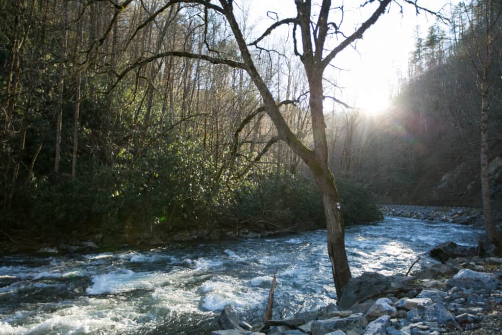
Thousands of people submitted emails and other public comments about the future of the Pisgah National Forest and the Nantahala National Forest. Seen here is a stretch of the Nantahala River in Cherokee County. Colby Rabon / Carolina Public Press

Lengthy and interesting article by Jack Igelman on the Nantahala and Pisgah forest planning process.  Theirs is particularly interesting because they have two collaborative groups, and because they are in a part of the country with very different history, culture and so on from the West.  They’re fortunate (and so are we)  that they have a reporter with the patience and fortitude to dig into the complexities of the people and the process.
It’s worth reading in its entirety, and I’ve just selected a couple of paragraphs below. There is also a discussion of the “two-tiered” approach.

What were the issues?

According to the comments of the Stakeholders Forum, the key issues are forestry and restoration, special designations, sustainable recreation and wildlife.

While the members agreed on “general values” associated with those issues, they disagreed on the “mechanisms” to achieve a range of conservation, recreational and economic objectives.

“The elephant in the room was the issue of wilderness,” Prater said.

Some members were concerned that the proposed plan may open land for timber harvesting that is also suitable for inclusion in the National Wilderness Preservation System. Alternatively, other members were concerned about overly restricting the ability to harvest trees for restoration or economic purposes.

According to the comments submitted by the Stakeholders Forum, “some members strongly support wilderness recommendations; some are willing to live with wilderness recommendations; and some are not supportive of wilderness recommendations.”

Prater said the Stakeholders Forum fell short on specific recommendations, “but we identified fertile ground for compromise. It’s a process. We admitted to areas that we couldn’t reach agreement that are too volatile or controversial, but acknowledged they exist.”

Lang Hornthal of EcoForesters, a nonprofit forestry organization based in Asheville and a member of both collaboratives, said the Stakeholders Forum’s final comments also helped explain why some interests disagree.

“The narrative on forest planning is that the public hears just one side of the debate within the lens of what’s important to them, whether that’s the need for more wilderness or more active forest management,” Hornthal said. “The Stakeholders Forum served the purpose of helping the Forest Service better understand where conflict lies.”

Whitmire said one barrier to reaching consensus was that many of the participants had constituents to serve, himself included.

“I didn’t want to let sportsmen down,” he said. “Hunters and fishermen are really in tune with the forest, and sportsmen felt like we had a story to tell.”

What was beneficial, he said, was forming working relationships with other interests and demonstrating to the Forest Service what we “can agree on and don’t agree on.”

For example, members did not agree with how to approach old growth in the plan and that “there is no singular definition for ‘old growth’ that is broadly agreed upon across stakeholders,” and there was disagreement regarding the amount of inventoried old growth in the forests.

While the Stakeholders Forum was not as specific as the Partnership’s recommendations, members said the dialogue that occurred over several years was meaningful, especially for sportsmen, whose central concern was that game populations are suffering due to aging forests.

………………………..

For example, he said, the Forest Service should focus future projects in noncontroversial areas of the forests. Specifically, it should tread carefully in places where there is old-growth forest or areas that are recognized in the state Natural Heritage Program for their extraordinary biodiversity.

A case in point is the controversial Buck Project decision to harvest trees and restore forest in Clay County in Nantahala National Forest.

The decision, made in June, infuriated environmentalists, who said the project will harvest trees in sensitive areas of the forest that contain old growth and unique plant and animal species.

“In our viewpoint, it’s not that complicated,” he said. “If there is uncertainty around areas with old growth or unique species, then we need to tread lightly and err on the side of doing less.”

I wonder whether it would make sense to delineate the noncontroversial areas up front as part of the forest plan? Or whether that is part of the plan (perhaps suitable acres are also noncontroversail?)

Range of variation webinar (and more)

This is a topic that at least Sharon and I like to debate (though for some reason she didn’t weigh in here).  The Western Environmental Law Center is offering this hour and half webinar on July 17.  As far as I know, it’s open to the public.

PNW Forest Collaboratives Workshop Series Part 3: Historical Range of Variability (HRV): Uses and Various Approaches
 
Range of Variability (ROV) concepts – including Natural (NRV), Historic (HRV), Current (CRV), and Future (FRV) – are frequently used by the US Forest Service to help define land management goals. Nathan Poage, Forest Service Ecologist, joins us to provide an introduction to ROV terminology and examples of how the Malheur, Umatilla, and Wallowa-Whitman National Forests in the Blue Mountains have applied ROV concepts during project planning when addressing key requirements of the Eastside Screens. The discussion will include overviews of tools commonly used to conduct ROV analyses. Q&A will follow the presentation.
This webinar will be on Friday, July 17 from 10-11:30am Pacific Time.
Registration is required for this event. Register today by clicking this link.
Note that it also involves the Eastside Screens.  I don’t think I can make it, but I’d be interested in hearing about it.  I also wanted to point out that this is about how to apply these concepts to projects developed under antiquated forest plans that don’t include the concepts.  It was this kind of thinking that drove development of the requirement to do this instead as part of revising forest plans under the 2012 Planning Rule.  Natural Range of Variation (NRV) embraced by the Planning Rule is a required desired condition for ecosystems, which should not change over time, and therefore should not be redecided for each project.  I’d be interested in knowing how, once ROV is determined for a particular project here, it is then documented and used for future projects in the same ecosystem.
But maybe there would be more interest in this one:
PNW Forest Collaboratives Workshop Series Part 2: Collaborative Administrative and Judicial Review Opportunities
In this follow-up webinar to NEPA 101, WELC attorney Susan Jane Brown will give a presentation on and answer your questions about collaborative administrative and judicial review opportunities, and dig deeper into the administrative review process for the Forest Service, judicial review of agency decisions, and how collaborative groups can engage in these processes.
This webinar will be on Thursday, July 9 from 10-11:30am Pacific Time.
Registration is required for this event. Register today by clicking this link.

Make forest plans great again (for wildlife)


I often point out how the Forest Service is shirking its responsibility to adopt forest plans that provide ecological conditions needed for diversity and viability of at-risk species.  Most recently, I listed some examples from the recently released Rio Grande revised forest plan.  Here is one guideline (there weren’t really any relevant standards):

EPC-G-1: To avoid or minimize adverse effects to listed species and their habitat, management actions should be designed with attention to threatened, endangered, proposed, or candidate species and their habitats. 

This says essentially nothing.

An important purpose of identifying and planning for at-risk species is to reduce the chance that they would need to be listed under the Endangered Species Act.  If this were a private landowner, conservation measures for at-risk (but not yet listed) species would be discretionary.  However, they could choose to sign a Candidate Conservation Agreement with Assurances (CCAA) with the listing agency to adopt conservation measures that would reduce the likelihood of listing in exchange for a commitment that the listing agency would not require anything more if the species did become listed.

Here is an example of one such enhancement of survival permit for Chinook Forest Partners, LLC Candidate Conservation Agreement with Assurances for Fisher in Oregon (until recently, a candidate for listing).  From the NEPA document (CE):

Activities that are covered by this CCAA and the associated section 10(a)(1)(A) permit are on-going and commonly practiced forest land management activities. These include timber harvest and hauling, site preparation and reforestation, and road maintenance and construction. Additionally, there may be some collection of minor forest products, fire suppression, and recreation (including legal hunting and trapping).

Goals and objectives for fisher include: improving our understanding of fisher distribution, densities, and habitat use, especially on non-federal lands where information is more lacking; conserving active fisher den sites to increase the survival of young; increasing public participation and support for fisher recovery and reintroduction by providing long-term assurances; and, monitoring potential future reintroduced fishers as they disperse from their release sites to determine success rates and provide information for improving success rates.

And here is what the private landowner committed to do in the CCAA to achieve those objectives for fisher (note: some are saying that this still isn’t good enough).  Given that the Forest Service is obligated by NFMA to provided ecological conditions for a viable population of at-risk species on national forests, why shouldn’t they be making at least this kind of commitment in their forest plans for public lands?  (This could make them adequate regulatory mechanisms to reduce the likelihood of listing under the ESA criteria.)

  • Specifically, CFP/CFM shall not conduct or authorize any of the activities described in the forest management activities in Section 4 (including but not limited to timber felling, pre-commercial thinning, reforestation, salvage of trees, prescribed burning, and brush control) within 0.25 miles of a den site, because those activities could result in disturbance or harm to denning fishers. CFM shall not authorize helicopter or fixed wing application of herbicide or fertilizer within 0.25 miles of an occupied den site between 15 March and 30 September until CFM is informed by USFWS or its agent the denning female has vacated the den site.
  • Provide protection of denning female fishers by restricting trapping and nuisance animal control activities on enrolled lands within 2.5 miles of den sites.
  • Report to USFWS, and ODFW or mutually agreed upon designated agents, within 48 hours upon finding any potentially occupied den sites or any dead, sick, or captured fishers on enrolled lands.
  • Cover all man-made structures on enrolled lands that pose an entrapment risk to fishers (e.g. large water troughs, old rail cars, or other containers from which fishers cannot escape) or place a device within the structure (e.g., wooden pole to allow fishers to climb out) to prevent mortality of fishers from drowning, starvation or dehydration
  • Where suitable habitat exists and where agreed upon by CFP and USFWS, allow the release of translocated fishers on enrolled lands
  • CFP will seek to have all of its timberlands third party certified to the Sustainable Forestry Initiative® (SFI),
  • CFP will take fisher habitat characteristics into consideration when assessing parcels for transfer or sale into permanent or semi-permanent conservation status.
  • Subject to safety, operability, fire hazard considerations, and salvage of timber following fire, windthrow or other natural or man-caused casualty, CFM will conserve existing and future standing deadwood, and, where available, focus leave tree retention on damaged, decayed, or deformed trees that are likely to provide or promote decay processes and structures beneficial to fisher or their prey.
  • CFM meets or exceeds the Forest Practices Act (FPA) live tree and snag retention, and down woody debris. For clearcut harvests greater than 25 acres, FPA requires that at least 2 snags or 2 green trees 30 feet tall and at least 11 inches DBH, at least 50% are conifer, plus at least 2 down logs or down trees at least 50% of which must be conifers that are at 6 least 6 feet long with a total volume of 10 cubic feet must be retained. CFM commits to retaining a minimum of 3 snags or green trees per acre on clearcuts larger than 25 acres, and these trees/snags will be retained for the life of the CCAA.
  • Trees >32” DBH will be retained the greatest extent possible, provided they do not pose safety hazards
  • CFM will instruct logging contractor to avoid whenever possible, driving machinery over, or otherwise damaging large down woody debris, thereby maintaining the integrity of stumps and logs that may be used by fishers and their prey.
  • CFM will seek to leave down woody debris and other structures important to fishers and their prey distributed throughout the unit instead of piling them into slash piles, will attempt to avoid mechanical damage or disturbance, and will locate skid trails around them where safety and operability considerations permit.
  • For slash piles documented as being used by fishers for denning on the enrolled lands, CFM shall not burn or otherwise mechanically alter such slash piles for a period of 5 years after the last year of known occupancy and use by a denning fisher.
  • CFM will avoid the use of rodenticides on lands enrolled in the permit area.
  • CFM will prohibit lessees from recreational trapping.

Has the Helena-Lewis and Clark got jobs for you

source: gustavofrazao / Getty

The Helena-Lewis and Clark National Forest revised forest plan was released recently and is now in the objection period.  A local newspaper decided to profile the benefits of the revised forest plan to “jobs” – 400 new ones are projected as a result of the revised plan.  As a former forest economist, I know how meaningless the economic analysis of forest plans can be, and this seemed a little far-fetched, so I thought I would take a look at it.

The EIS discloses the number of jobs resulting from recreation, grazing, timber, minerals, transfer payments and Forest Service expenditures.  That last item (which I think is mostly federal employees) makes up about half of the total employment benefit depending on alternative.  Actually, the number of jobs is the same for all of these categories in all alternatives, except for jobs related to timber harvest.  There, the preferred alternative (F) increases the timber jobs by five times over current levels (EIS Table 243, I get an increase of 497 from current levels), while roughly doubling the projected timber harvest volume over that resulting since 1980.  Elsewhere the EIS says, “An estimated 804 private industry timber jobs exist in this multi-county area.”  That doesn’t match the 119 shown in this table, but would mean the Forest would only increase industry employment by 50% or so, but still …  My point is just that this is suspicious and confusing.

The reality is that jobs created by Forest Service outputs are usually a very small part of a regional economy (the total number of jobs in this region is over 100,000, so that the total timber-related jobs is less than 1%) and the actual number of jobs will usually vary because of many factors that that Forest Service has no control over.  This is a good example of stuffing an EIS with information that does not help with the decision, and in fact may confuse it.

Then there is the question of why should we care.  The “regulatory framework” for social and economic benefits (p. 189 of the EIS) provides no authority for “creating jobs.”  (I doubt if there is one for doing something about “poverty levels” either, as Mac McConnell intimated here.)   The “findings required by other laws” included in the draft ROD do not include any related to social or economic growth.   And under NEPA, creating jobs would be a bad thing, since indirect adverse effects “may include growth inducing effects and other effects related to induced changes in the pattern of land use, population density or growth rate, and related effects on air and water and other natural systems, including ecosystems” (40 CFR §1508.8).

Of course, considering a specific effect on a specific industry or employer, might be a reasonable and relevant factor to consider for a long-term planning decision, if it were related to meaningful criteria about the “right” number of jobs and why, and properly disclosed in a record of decision.  I’m just not seeing that here, in this draft ROD:

The Plan also contributes to social and economic sustainability by providing plan components that collectively support an array of public benefits including jobs and income, … (p. 20)

This statement would have been true for any alternative, so the economic analysis contributed nothing.  It’s unfortunate that this was picked out as “news,” giving the wrong message about what our national forests are for, as well as raising questions about what is really going to happen.