Private land conservation easements benefit national forest wildlife

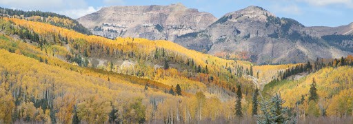
In 2009, the owner of a golf course in Georgia donated a conservation easement to a non-profit land trust.  The easement included roughly 57 acres of primarily bottomland forests and wetlands along the Savannah River that would not be developed.  That land is directly across the river from the Sumter National Forest, 700 feet away.

To obtain a tax deduction for the conservation easement, it has to be “exclusively for conservation purposes” based on one or more of the criteria in the Internal Revenue Code.  They include:

(ii) the protection of a relatively natural habitat of fish, wildlife, or plants, or similar ecosystem,

(iii) the preservation of open space (including farmland and forest land) where such preservation is–

(I) for the scenic enjoyment of the general public, or

(II) pursuant to a clearly delineated Federal, State, or local governmental conservation policy,

and will yield a significant public benefit,

These issues were recently litigated by the IRS for this easement in the 11th Circuit Court of Appeals, which found the donation to be eligible as both habitat (ii) and scenic open space (iii)(I).  IRS Treasury Regulations elaborate on these requirements with regard to habitat by including “natural areas which are included in, or which contribute to, the ecological viability of a local, state, or national park, nature preserve, wildlife refuge, wilderness area, or other similar conservation area.”  However, the court accepted expert testimony from the IRS that the easement did not support the forest’s ecological viability.

There is no mention of testimony from the Forest Service. The 2012 Planning Rule stresses that, planning for ecological integrity must take into account “conditions in the broader landscape that may influence the sustainability of resources and ecosystems within the plan area” (36 CFR §219.8(a)(1)(iii)).  In addition, where a national forest plan area can not maintain a viable population of a species of conservation concern, “the responsible official shall coordinate to the extent practicable with other Federal, State, Tribal, and private land managers having management authority over lands relevant to that population” (36 CFR §219.9(b)(2)(ii))).

The also court determined, regarding open space (iii)(II), that, “There is no qualifying federal, state, or local government conservation policy that applies to this land…” In fact, the Forest Service Open Space Conservation Strategy includes this vision: “Private and public open spaces will complement each other across the landscape to provide ecosystem services, wildlife habitat, recreation opportunities, and sustainable products.”

In this case, private land adjacent to a national forest was conserved, but there is no evidence that the Forest Service was even paying attention.  The Forest Service needs to be more alert to these opportunities that would benefit national forest resources as well as contribute to greater national conservation needs.  Maybe if the Forest Service promoted its conservation policies better, they would facilitate more donated easements and protect more habitat for wildlife species that also use national forests.

Along somewhat the same lines, conservationists in Florida are striving to conserve the Ocala to Osceola Wildlife Conservation Corridor, which would connect the two national forests of those names across 50 miles of multiple other ownerships (including a military base).  Here is a presentation by the U. S. Natural Resources Conservation Service, which uses funding from the federal Farm Bill Resource Conservation Partnership Program to purchase conservation easements and create wildlife habitat on private lands within the corridor.  (This is the kind of “governmental conservation policy” that should also support federal tax deductions for donated conservation easements.)

The federally endangered red-cockaded woodpecker is an excellent example of a species that the Forest Service needs to coordinate management with others for, and here’s a bit of the success story about that in the O2O Corridor.

A red-cockaded woodpecker (RCW) captured at Camp Blanding in Clay County is evidence that a project led by North Florida Land Trust to preserve land within the Ocala to Osceola (O2O) wildlife corridor is working.  The bird captured at Camp Blanding was the first time this endangered species had moved between one of the national forests and the military installation since they began banding and recording the birds over 25 years ago.

“USDA Forest Service” is listed as a “partner” by NRCS, and the “National Forest Service” by the North Florida Land Trust.  The latter gives me a sense of how deeply the Forest Service has not been involved, and I sure can’t find anything about this effort on either national forest website or using a national search.  It’s too bad the Forest Service isn’t providing more leadership (and getting more of the credit) for conserving its important wildlife resources.

The latest on forest plan revisions (and wildlife)

In the past couple of months the Forest Service has increased its family of forest plans revised under the 2012 Planning Rule to six.  The Chugach and Rio Grande national forests have joined the Francis Marion, Flathead, El Yunque, and Inyo.  The Forest Service revision schedule is over six months old, but the Helena-Lewis and Clark National Forest may be next.

Here’s what looks like a news release from the Rio Grande.

The plan prioritizes the use of active management to foster sustainable and productive use of the forest. Compared to the 1996 plan, this new plan is less prescriptive and emphasizes flexibility and commitments to working with the public. Management direction has been updated for all plant and wildlife species.

This seems to capture the mood of the Forest Service these days.  The only commitments it has ever liked are those they have to do any way, especially if they are check-the-box kinds of procedural commitments like “working with the public.”  In their “update” for wildlife, rather than commit to protecting wildlife as required by NFMA and the Planning Rule, they infuse the plan with discretion.  Here’s some examples of what the Rio Grande seems to feel (based on the best available scientific information) would “provide the ecological conditions necessary to: contribute to the recovery of federally listed threatened and endangered species, conserve proposed and candidate species, and maintain a viable population of each species of conservation concern within the plan area” – which plan components “must” do (36 CFR §219.9(b)).

DC-SCC-2: Structure, composition, and function of coniferous forests, including late seral forests, meet the needs of associated species, including species of conservation concern. (Forestwide)

There is a series of these desired conditions for different ecosystems that all say the same thing, which is “we’ll figure out what these species need later.”  The Planning Rule requirement is for “plan components” to meet the forest plan requirement, not for project-by-project decisions about how to protect at-risk species.  Let’s see if the standards and guidelines add anything …

G-SCC-3: To maintain viability of species of conservation concern, reduce habitat fragmentation and maintain structural conditions of sagebrush ecosystems through design of management activities. Patch sizes should not be less than 5 acres. (Forestwide)

TEPC-G-1: To avoid or minimize adverse effects to listed species and their habitat, management actions should be designed with attention to threatened, endangered, proposed, or candidate species and their habitats. (Forestwide)

Wow.  Apparently any “structural conditions” will do, but they at least appear to concede that there is a minimum patch size needed for some species in sagebrush ecosystems (this is actually the kind of “specific” desired condition the Planning Rule envisioned), but conversely there is not enough science to tell them what is needed for anywhere else.  If the courts say this is good enough, then the Forest Service has essentially excised the diversity requirement for forest plans from NFMA.  (Never mind the question of “how much did the Forest Service spend on forest planning to get THIS?”)  (This is a continuation of a pattern discussed here, and may lead to some of the same kinds of problems under ESA.)

Forest planning for mechanized use in recommended wilderness

We’ve talked about whether mountain bikes should be allowed in areas recommended for wilderness designation by the Forest Service in a forest plan, for example, here.  Most of the angst has been related to a policy adopted by Region 1 that many interpret as excluding this use because allowing it would reduce the likelihood that an area would actually be designated.  Here’s an example from another region of how a forest plan would address this question.  This language is from the draft EIS for the Nantahala-Pisgah National Forest revised plan (North Carolina). While this is written about the effects of wilderness designation, the DEIS also makes it clear what activities the Forest thinks would create a risk to future wilderness designation options.

Wilderness recommendation and designation would remove the potential to generate revenue from timber production, forest product sales, and other land uses which support surrounding development such as utility or transportation corridors. No new mineral claims would be filed, but valid existing claims would be allowed to operate.

Existing roads within recommended areas would either continue to be maintained as linear wildlife fields or decommissioned and allowed to return to a natural state. No new wildlife fields would be created nor any timber harvest activities allowed. Restoration activities where the outcomes protect wilderness characteristics would be allowed to continue, including monitoring, relocation of animals, habitat improvements such as removal of nonnative fish species and nonnative invasive plant species, stream improvements, and rehabilitation of recreation impacts.

Existing trails would continue to be maintained to allow for hiking and equestrian use per current trail-use designations, but mechanized transport such as bicycles or carts would be prohibited in all recommended areas (with exception of approved mobility devices for the impaired). Commercial collection of non-timber forest products such as galax or ginseng, would not be permitted; however, collection for non-commercial or tribal purposes would be allowed. Other commercial activities such as recreation special-use events would also be prohibited in areas recommended for wilderness designation.

The mountain bike decision by the Forest was the followed discussions with a public working group, which also included consideration of whether future wilderness recommendations could be conditioned on providing adequate mountain bike trails.  The location of the trails was potentially less important than the amount, but it is unknown at this time where additional trails might be and how that might affect wilderness boundaries.  Consequently, trails in a potential wilderness area could be managed to phase out the existing but unauthorized mechanized use gradually after providing other comparable opportunities, and when certain conditions were met, appropriate areas would be formally recommended, with the full support of both mountain bike and wilderness groups.  But the Forest ended up recommending the area for wilderness, which would exclude the use.
In effect, the Forest appears to have considered an alternative that would have not recommended an area, but committed to a process that would recommend some or all of it as wilderness in the future (presumably with a plan amendment) when certain objectives are achieved.  You don’t find this alternative mentioned in the DEIS, though, as one considered but eliminated from detailed study.
Back in R1, the Nez Perce-Clearwater draft revised plan includes a suitability designation regarding mechanized use in all areas recommended for wilderness designation in a particular alternative.  Of the four action alternatives, one has no recommended wilderness and one would allow mechanized use in the areas recommended.  (The DEIS does not say what the current direction for recommended wilderness is.)  There is no preferred alternative.


Science Friday: When is Research Useful and Who Decides? Uncertainty and Current Decisions

A pretty view of picnic grounds on Homestake Road (1890) Library of Congress https://www.loc.gov/pictures/item/2004665560/

Jon made a comment yesterday that I think is worth exploring in detail. He said:

If this is just a compilation of existing data, that’s one thing. If this will be their basis for future planning, and they are saying they are going to ignore future climate change, it might be hard to argue that’s the best available science.

I’m sure that no one wants to “ignore climate science.” On the other hand, how exactly should specific pieces of climate science be applied to a decision? Who makes that call? In the past, when the topic was less adversarial (say reforestation practices), the National Forests hired experts who would make that determination and decide what Forests should do. Now, I’m sure it won’t surprise you that even with these less-charged kinds of decisions, there was sometimes disagreement between practitioners and researchers (as well as within each community). But most of the time these did not boil over into public spats as it was taken for granted that the authority to decide lay with the local technical expert. Researchers were content to publish, and practitioners were content to pick the best approaches based on experience. Many times FS researchers and National Forests worked closely together in what we might call today “co-design and coproduction”. Today, though, we have broader questions, with more disciplines involved, so that there may not be one “expert,” and the public wants to understand the scientific questions where they have policy relevance. Both of those changes present challenges.

As I’ve argued before, we don’t have a clue as to how microclimates perceived by trees will change due to climate change, and we also don’t know how those changes might affect living trees, nor do we know how those changes might affect their offspring. Remember, climate models as used for projecting future conditions have economics as an input. I think, reading the views of experts right now, they have no clue how much the Coronavirus may set back worldwide economies and emissions. If you run out this string of cumulative cluelessness about the future, it becomes a decision question for stakeholders and decisionmakers- we don’t know, so how should that uncertainty affect our decisions? We also don’t have a clue as to whether trade policies will let an invasive diseases or insects into the US which will decimate the ponderosa pines on the BH. The future, is indeed, unknown and uncertain. In fact, there are decision sciences that research how best to decide under conditions of uncertainty.

So, what to do about our cluelessness about future tree growth? I belong to what I might call the Pete Theisen school. He was the R-6 Regional Geneticist who said that additional growth due to tree improvement would come out in future measurements, so we shouldn’t try to model it in growth and yield models. Applying that to climate change, we would measure tree growth every ten years or so (or whatever the cycle is today) and incorporate that into future decisions. What we might call “monitoring the forest plan.” As we would then instances of insects, diseases, and fires.

But as Jon points out, we also have the question of what is the “best available science?”. We’d have to ask “who decides what is best? Based on what criteria?”. Peter Williams has spoken of the concept of “research utility.” I like that approach because it involves practitioners and stakeholders in determining whether a study is useful or relevant to the decisions that, at least on public lands, are essentially public decisions.

For me, the “best science” of tree growth in the Black Hills is what people have recently measured, knowing that it could change due to climate change or a variety of other factors, unknown, uncertain or unknowable.

More research on less tree growth after fire

(RJ Sangosti, The Denver Post)


This article summarizes some recent research on the topic:

Among Stevens-Rumann,’s work was a 2017 study of nearly 1,500 sites charred by 52 wildfires in the U.S. Rocky Mountains. Her research found that lower elevation trees had a tough time naturally regenerating in areas that burned between 2000 and 2015 compared with sites affected between 1985 and 1999, largely due to drier weather conditions.

More recently, a 2019 study written by her colleague Kerry Kemp found that both Douglas fir and Ponderosa pine seedlings in the Idaho’s Rocky Mountains — just south of B.C. — were also struggling in low-lying burned areas due to warmer temperatures, leading to lower tree densities.

Both studies attribute climate change to be the lead cause of why the trees are struggling to grow back in certain fire-scarred areas.

As a result, some ecosystems will no longer be able to support tree species. Instead they may convert to grasslands, she said.

We’ve talked about this before (for example, here).  But I would like to know how this kind of information is being incorporated into long-term planning for timber harvest levels. In accordance with the requirement for sustainability on national forests, we should be assuming forest growth consistent with the natural range of variation, which should reflect the effects of climate change on future forests.  What I would expect to be seeing based on this kind of research is reduced area suitable for timber production because it would become too dry, and reduced volume resulting from reduced density, slower growth rates and more frequent fires.  “Sustained yield” means that projections of lower future timber yields may lead to reduced near-term volume. I’ve looked at the timber volume documentation for a few forest plan revisions, and I haven’t found anything there about climate change (there’s usually an unconnected section on the effects of climate change somewhere).  (Projected timber harvest volumes are not tending to go down in revised forest plans.)  Maybe that just requires digging deeper than the public-facing documents or maybe it’s not happening.   Does anyone know more about this?

Texas congressional delegation wants federal oil & gas leasing to fire up in the state

From the Forest Service scoping notice:

The National Forests and Grasslands in Texas (NFGT) is initiating the preparation of an environmental impact statement (EIS). The EIS will analyze and disclose the effects of identifying areas as available or unavailable for new oil and gas leasing. The proposed action identifies the following elements: What lands will be made available for future oil and gas leasing; what stipulations will be applied to lands available for future oil and gas leasing, and if there would be any plan amendments to the 1996 NFGT Revised Land and Resource Management Plan (Forest Plan).

The Forest Service withdrew its consent to lease NFGT lands from the Bureau of Land Management (BLM) for oil and gas development in 2016. The reason for the withdrawal of consent was due to stakeholder concerns, including insufficient public notification, insufficient opportunity for public involvement, and insufficient environmental analysis. There is a need to analyze the impacts of new oil and gas development technologies on surface and subsurface water and geologic resources; air resources; fish and wildlife resources; fragile and rare ecosystems; threatened and endangered species; and invasive plant management. There is also a need to examine changed conditions since the Forest Plan was published.

These leasing availability decisions are forest plan decisions that were most recently made in 1996.  The action proposed by the Forest Service would result in changes in the stipulations and would therefore require a forest plan amendment.  The changes would shift about 11,000 acres from “controlled surface use” to “no surface occupancy,” and remove timing limitations from about 35,000 acres.

A letter from five Republican members of the delegation disagrees with the premise that the 1996 analysis was inadequate, and is unhappy with the pace of the amendment process.

The published timeline anticipated a Draft EIS in the winter of 2019 with the Final EIS expected in the fall of 2020. We are concerned that this timeline is no longer achievable given current pace of progress.

We request that USFS end the informal comment period, issue a Draft EIS this spring and ultimately approve the Final EIS that reinstates BLM’s ability to offer public competitive leases of National Forest and Grasslands in Texas for oil and gas leases before the end of 2020. While USFS is required by law to respond to eligible comments received within the public comment window (CFR218.12), the Forest Supervisor also has the authority to declare the available science sound, conclude the public comment period, and proceed with the issuance of the scoping comments and alternative development workshops as the next steps ahead of a Draft EIS (CFR219.2.3, 219.3) (sic).

That last sentence got my attention as the kind of congressional attention to Forest Service decision-making that might cause them to cut a legal corner here or there (especially when there is an election coming).  I also noticed the absence of any reference to the new requirements for amendments, and maybe the delay could have something to do with this becoming evident to them as a result of scoping.  36 CFR §219.13(b)(6):

For an amendment to a plan developed or revised under a prior planning regulation, if species of conservation concern (SCC) have not been identified for the plan area and if scoping or NEPA effects analysis for the proposed amendment reveals substantial adverse impacts to a specific species, or if the proposed amendment would substantially lessen protections for a specific species, the responsible official must determine whether such species is a potential SCC, and if so, apply section §219.9(b) with respect to that species as if it were an SCC.

I found nothing in the EIS for the 1996 revision about effects of oil & gas development on at-risk wildlife species.  You’d think the new information since 1996 might have something to do with effects on climate change, too.

The Pisgah-Nantahala Forest Plan- Reflections From the Newsmakers Forum

NC Rep. John Ager, D-Buncombe, asks the panel a question about the national forests during Carolina Public Press’ Feb. 19 forum at the University of North Carolina at Asheville.
Thanks to the Carolina Public Press for hosting the Newsmakers Forum on the Pisgah-Nantahala Forest Plan and making it available as a live broadcast with questions from those online. They deserve a shout-out, as does reporter Jack Igelman, for following the tedious (to many) twists and turns of the planning process. He has really dug into the details (where the Devil is thought to dwell) and tried to understand different points of view. If The Smokey Wire had a “Best Coverage of a Forest Plan” award, Jack would win hands down.

Here are some of my thoughts from the discussion. I know folks on The Smokey Wire (especially Sam Evans) have been very involved, so I’d appreciate any thoughts of your own and corrections.

1) While the history of pre-National Forest cultures and livelihoods on the land is generally better known and documented in the east, many of the issues discussed sound similar to parts of the West. They spoke of increasing/recreation, second homes and subdivisions, fire management, and vegetation management including commercial tree removal. Topics like sustainable recreation, increased pressure, and increased visitation are just as difficult in many places in the West.

2) One of the advantages of strategic planning or large landscape planning ideally is that people can work together to find common ground at a broader scale than “this project” or “that problem.” Based on the discussion, and comments by Sam Evans here, that generally seems to be how it is working. One person said that this collaboration might continue into implementing the plan. It did sound as if the forest plan perhaps provided a nexus for discussions and collaboration that otherwise would not have happened, as a “good forest planning process” ought. I am not sure how much of that is due to the Forest Service individuals, to collaborators, or to the unique culture, history and relationships on this land. Would be an interesting social science study to look at the the different forest planning efforts in about 10 more years.

Sidenote: I think we might disagree that, for example, a rancher from Burns, Oregon should have as much say about the Pisgah-Nantahala as someone in the collaborative group, and an insurance agent from Oklahoma who has never been there should have as much say as someone whose family has traditionally used the land for four generations. It’s interesting to think about “who cares about forests that are far away from their home” and why. I didn’t get the impression that this plan has major out-of-area interests, but I could be wrong.

3) Someone on the panel cited a book, Blue Ridge Commons, 2012 book by Kathryn Newfont. Here’s an excerpt from a blurb by University of Georgia:

In the late twentieth century, residents of the Blue Ridge mountains in western North Carolina fiercely resisted certain environmental efforts, even while launching aggressive initiatives of their own. Kathryn Newfont examines the environmental history of this region over the course of three hundred years, identifying what she calls commons environmentalism-a cultural strain of conservation in American history that has gone largely unexplored.

Efforts in the 1970s to expand federal wilderness areas in the Pisgah and Nantahala national forests generated strong opposition. For many mountain residents the idea of unspoiled wilderness seemed economically unsound, historically dishonest, and elitist. Newfont shows that local people’s sense of commons environmentalism required access to the forests that they viewed as semi-public places for hunting, fishing, and working. Policies that removed large tracts from use were perceived as “enclosure” and resisted.

These battles often pitted industrialists against environmentalists. Newfont argues that the side that most effectively hitched its cause to local residents’ commons culture usually won. A few perceptive activists realized that the same cultural ground that yielded wilderness opposition could also produce ambitious protection efforts, such as Blue Ridge residents’ opposition to petroleum exploration and clearcut timber harvesting.

I still don’t see Jane’s Sawmill as “industrial” but.. Perhaps there is an element of “keeping traditional people and uses out” that we also see in closing access in the West (outside of the Designated/Wilderness debate), although the argument is that it’s better for wildlife and the Forest Service can’t afford the upkeep on roads. But I have definitely heard a dislike for reduced access in comments on western forest plans (and travel management). Maybe east and west are not all that different.

Pisgah-Nantahala Draft Plan and EIS, Tiered Approach and Live Stream Meeting Tomorrow

Tomorrow afternoon is a live stream on the “Future of Pisgah-Nantahala National Forests in North Carolina” Newsmakers Forum, from Asheville, North Carolina. It’s free and might be interesting to sit in on.

We’ve previously discussed this forest planning effort. Jack Igelman of Carolina Public Press has been following it (and doing a great job IMHO) and has a story here. Here are some excerpts from today’s piece.

Here is Sam Evans on the “two-tiered” approach.

Two-tiered approach
Another unique aspect of the plan is a “two-tiered” approach to land stewardship. The first tier identifies activities the Forest Service has the budget and other resources to accomplish, while the second tier outlines what the agency can accomplish with the help of partners.

Sam Evans, an attorney with the Southern Environmental Law Center, likes the two-tiered approach. He said that while the idea has been used before, the concept hasn’t been used to structure a forest plan and has the potential to incentivize more collaboration among user and advocacy groups.

“This is an idea that came out of the collaborative process, so it shows that the Forest Service was listening to the public,” he said.

However, Evans does have concerns about how the two-tiered approach will work, such as ensuring that clear “triggers” indicate when the agency moves from one tier to the next for a specific plan objective, such as forest restoration.

Thinking of Tier 2 objectives as “stretch goals,” Evans said, “The trick is to figure out how we can reach Tier 2 objectives in an integrated way without interfering with other goals.”

For example, he said, rather than identifying a single number of acres for timber restoration, the agency can mesh restoration objectives for specific species, such as pine and oak restoration, under a broader silvicultural objective.

“That is the No. 1 thing … to figure out what those triggers are and get them clearly written into the plan between draft and final,” he said. “That’s the biggest piece of work for the collaborative groups and the Forest Service.”

I like this general idea, as it sounds transparent and trust-building, but I can’t quite get a mental image of what “mesh restoration objectives for specific species, such as pine and oak restoration, under a broader silvicultural objective,” would look like. Perhaps Sam can weigh in on this.

I thought this example was interesting.

While Kelly believes the “building blocks” of the plan appear strong, such as the tiered approach, he’s hoping to provide feedback that will add specificity to the plan in areas where he said it’s lacking.

For example, he said, the current management plan finalized in 1994 requires the use of an aerial device to harvest trees on slopes steeper than 40% to prevent erosion and avoid landslides.

The proposed plan removes that requirement and allows an agency specialist to make a decision depending on the site and conditions.

While that may be a relatively minor detail, Evans said Kelly’s concern highlights a central tension in this plan: the balance between “certainty” and “flexibility” in management.

I see it as we can’t predict what technologies will be available in 25 years, nor what concerns will be then, and it’s best to use “best available science” for the project when the project document is completed.

I agree with Sam that:

The Forest Service is shifting its management toward big-picture ecological goals, such as restoring ecosystems and using fire, that require flexibility in management,” Evans.

“That’s admirable, but that discretion and flexibility can vary depending on the personnel and has the potential to be misapplied.”

However, IMHO the place to avoid misapplication is in real time, with real current science with the actual project document.

Anyway, lots of interesting info and quotes in this piece, so feel encouraged to find something that resonates (or doesn’t) with you and comment below.

Tahoe plan amendment for use of wildfires


(Not in the American Planning Association context of this publication, but in the NFMA context of national forests.)

I was alerted to the Tahoe situation by this supportive opinion piece in a local paper, which includes a link to the project record for the proposed plan amendment.  It provides an opportunity for a look at how fire management, and in particular wildfire management for resource benefits, should be addressed in national forest planning.  Fire and planning have had a rocky relationship in the Forest Service over the years, but here’s some current guidance.

Guidance for Implementation of Federal Wildland Fire Management Policy (February 2009) includes this:

Management response to a wildland fire on federal land is based on objectives established in the applicable Land/ Resource Management Plan and/or the Fire Management Plan.

Fire Management Plans, programs, and activities support land and resource management plans and their implementation.

The L/RMP will define and identify fire’s role in the ecosystem. The response to an ignition is guided by the strategies and objectives outlined in the L/RMP and/or the Fire Management Plan.

Values to be protected from and/or enhanced by wildland fire are defined in the L/RMP and/or the Fire Management Plan.

Wildland fire will be used to protect, maintain, and enhance resources and, as nearly as possible, be allowed to function in its natural ecological role. Use of fire will be based on L/RMP and associated Fire Management Plans and will follow specific prescriptions contained in operational plans.

Fire Management Plans are strategic plans that define a program to manage wildland fires based on the area’s approved land management plan.

The 2014 National Cohesive Wildland Fire Management Strategy required by the Federal Land Assistance, Management, and Enhancement Act of 2009 (FLAME Act), includes as a priority, “increasing use of wildland fire.”  Figure 3.4 shows a national map: “Spatial pattern of counties where options for managing wildfires
for resource objectives and ecological purposes might prove useful.”

The Forest Service Planning Handbook advises (among other things, §23.11c):

Standards or guidelines.  The plan may include standards or guidelines related to basic smoke management practices, non-fire fuels treatments, post-fire rehabilitation, prescribed fire treatments, and wildland fire responses.  A guideline or standard may provide guidance on when or how a specific tool is appropriate.

Here is the language from the current Tahoe forest plan (a standard):

Fire suppression strategy is control (with fast, aggressive initial attack) except where the contain strategy is authorized for specific management areas at fire intensity levels described under the practice description. Strength of attack will be based on hazard rating, fire weather, and values at risk.

The exceptions:

The Forest Plan allows Fire Managers to utilize fire for resource benefits in only a few limited areas of the Forest and only if the fire can be contained within an isolated fuelbed of 5 acres or less, a situation rarely encountered and at a scale too small to achieve meaningful ecological restoration or other resource benefits.

Here is the comparable language proposed for the amendment (a guideline):

Use naturally- (lightning-) caused wildfire ignitions to meet multiple resource objectives when and where conditions permit and risk is within acceptable limits. Multiple resource objectives include: re-introducing fire as a necessary ecological process; enhancing plant and wildlife habitat, including critical habitat for threatened and endangered species; improving forest health, conserving ecosystem services; managing smoke emissions; reducing fuel loading; and/or protecting communities and infrastructure.

So this all sounds like an improvement, but nowhere in the proposal or the discussion of the proposal does the Forest mention the role of the forest plan.  The “multiple resource objectives” should come from there.  They list 14 factors, and the only one that indirectly implicates the forest plan is “cultural and natural values at risk.”  A simple fix to the proposed guideline would be to use such ignitions to “achieve the desired conditions and objectives of the forest plan,” and add to the factor “… values at risk based on the forest plan.”  That should go without saying, but by failing to mention the plan, it suggests that decisions about prescribed wildfires could be made without reference to that document.  The forest plan may not be the first thing that comes to mind when a fire starts, but management of a fire, like everything else a national forest does, must be consistent with the applicable forest plan.

I do like the direct approach the Tahoe is taking with the smoke issue.

While the amendment could have short-term adverse effects on certain resources, for example, air quality, its effects would be largely beneficial by restoring the ecological role of fire and protecting forests and communities from the significant adverse effects of large-scale, uncharacteristic wildfire.

The proposed amendment is aimed at restoring air quality (36 CFR 219.8(a)(2)(i) by serving to offset smoke emissions from large, uncharacteristic wildfires


When forest plans are revised, a more comprehensive approach should be taken.  This will give you an idea what the Inyo has done.


Trump Administration takes on BLM planning

An internal BLM document (linked below) may be the first step in revising the agency’s planning regulations (Planning 3.0?).  The proposal to remove NEPA requirements for land management plans is getting some attention.

The BLM may propose a land use planning rule that will “remove NEPA requirements from the planning regulations,” referring to the National Environmental Policy Act, according to the document on possible changes to such rules that was shared with states and former BLM officials.

The U.S. Forest Service similarly attempted to exempt national forest plans from NEPA during the George W. Bush administration, but a federal court struck down that effort in Citizens for Better Forestry v. USDA in 2007 because it violated NEPA and other federal laws.

“If the BLM proceed with this proposal, it will certainly be challenged, and I suspect that, like the FS [Forest Service], the BLM will lose,” Mark Squillace, a natural resources law professor at the University of Colorado, Boulder, said.

But it looks good to try, I guess. Current BLM regulations require an EIS for its plans, and the Forest Service explicitly required an EIS for forest plan revisions in its 2012 Planning Rule after its earlier rules were struck down for trying to avoid NEPA compliance.  This effort by BLM is in addition to the recent proposed changes in the CEQ NEPA regulations discussed here.

Here’s a little background on BLM planning requirements:

Dec. 12, 2016 BLM publishes its Planning 2.0 Rule, which updates land use planning procedures.

Feb. 7, 2017 The House of Representatives passes a resolution to repeal the rule under the Congressional Review Act (CRA).

March 7, 2017 The Senate passes a resolution to repeal the rule under the CRA.

March 28, 2017 President Trump signs the resolution disapproving the rule. Under the CRA, BLM may not promulgate a rule that is “substantially the same.”

(Maybe we’ll get to see lawsuits about what “substantially the same” means.)