Cool New Tool for Coloradans: Recreation Impact Monitoring System

If there were a The Smokey Wire Fix Not Fight Timely Innovation Award, this effort by the Colorado Mountain Club would be a winner. We’ve been talking about keeping track of recreation impacts and here is a way for volunteers to provide information, and also for volunteers to help fix the problems. I’m sure others have been frustrated by wanting to report something on a trail and not having the time to figure out which District you’re on, or want to call around to find the Recreation staff. And if it’s that hard for retirees, it must be more difficult for others.

Below is some information about the RIMS app and here’s a link to an overview pdf. Here’s the website where you can take a training video and learn to use the app.

Features
• Geo-located point data
• Drop-down surveys & objective metrics
• Photos
• Online maps & functionality
• Cloud sync for real-time data

Users
• Agency Staff
• Stewardship Organizations
• Trained Volunteers
• Enabled for Android or Apple devices
• Simple & Easy to Use!

Accessibility
• Trail, Campsite, Sign, Facility & Visitor Use
Assessments
• No Cost for data collection
• Custom Assessment Development (invasive species,
wildlife monitoring, etc.)

The CMC folks worked with agency staff to develop it, and here’s how agency staff and volunteers can use it:

There are a few ways both agencies and stewardship groups can access the data –

· All assessments are viewable through the RIMS app itself and users (including agency staff) can filter the data by assessment type and date. We are adding a new “sharing” function in the next month which will allow a user to send the details of an assessment directly via email.

· The webviewer is a browser-based tool that displays assessments on a map an allows for some additional filtering.

· Finally, our customized reporting dashboards are available for land managers or stewardship groups this spring and include geographically filtered data (e.g. only assessment within a Forest Service Ranger District’s boundaries) as well as charts, graphs, maps, and full data exporting capabilities. The dashboards can also generate automatic email notifications on a daily/weekly/monthly basis to help direct rapid response stewardship work. For example, a trail crew leader might want a weekly report of all the new downed trees that have been reported on the district to help inform where to direct staff or volunteer efforts.

The workflow for resolving issues is as follows: App users can re-assess any survey in the RIMS app to update the current conditions at that location. For example, if a downed tree is reported June 1 and a volunteer hikes that same trail June 7 to remove the downed tree, they can re-assess the first survey, remove the record of the downed tree and the issue will be marked as resolved within the app database. If for some reason the volunteer does not use the app to report the work they completed, another user could hike the same trail at any point after that and re-assess the original survey to mark it as resolved. The re-assessments are also helpful for measuring change over time: for example, re-assessing a dispersed camping area year after year to measure growth of the site, increased vegetation damage, etc.

We are still working through some details of this workflow but the ideal scenario in the future is that we have enough folks using RIMS and re-assessing issues that we always have a relatively current view of current conditions on the ground.

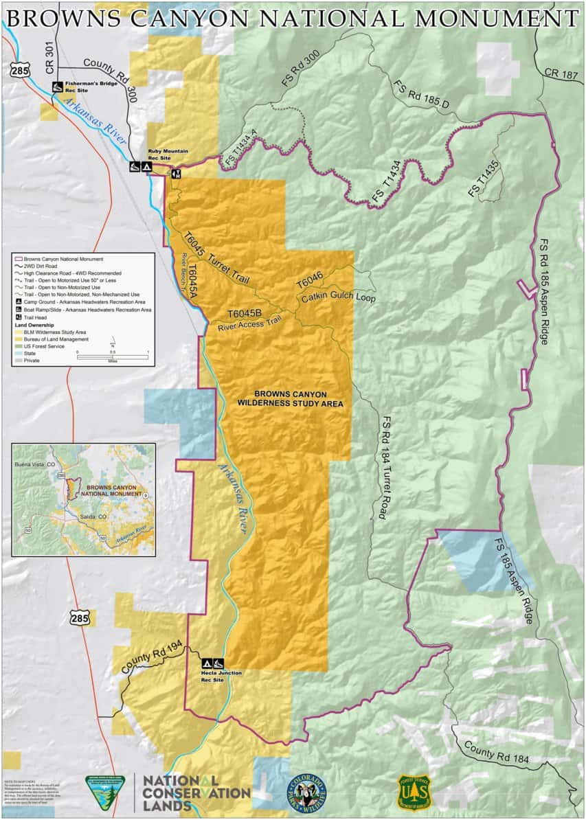
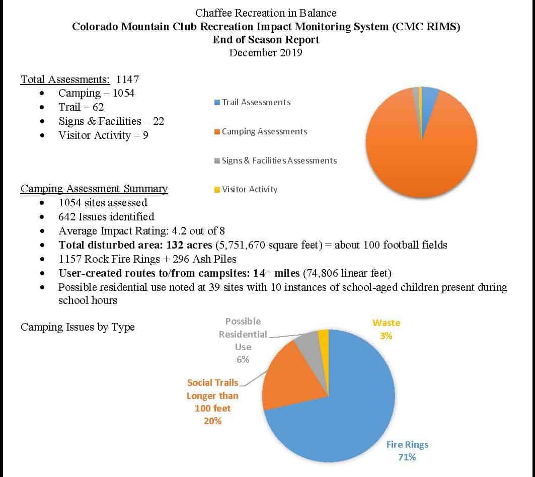
Here’s a link to a report from Chaffee County from July to November. My pet peeve that this could help with are dispersed campers that don’t respect the two week camping ban, or leave their trailers in a spot for what appears to be all of hunting season, taking up the choicest spots and not actually being there.

The image above is from the Chaffee County report. The CMC folks’ intention is to ultimately go national, so please spread the word in your area!

OIA Study: Not Enough People Participating in Outdoor Recreation

When people design, or read the results of studies, scale is an important concept to keep in mind. Though this is not a scientific report, the choice of scale is a value choice, not a science choice. My old examples were economic studies of the effects of reducing timber harvest on federal lands in the Northwest. If your scale was Forks, Washington, the State of Washington, or the US, the conclusions about impacts were likely to be different. A national or even worldwide average may not be true in any individual place. You can take the average of apples, oranges and kumquats, but it may not be all that meaningful in understanding how to grow fruit. That’s why designing studies with the idea of how you are going to use them is so important.

In January 2020, the Outdoor Industry Association released a national study that concluded: Americans went on one billion fewer outdoor outings in 2018 than they did in 2008. Those of us who recreate on National Forests might wonder why those numbers would be so different from what we observe, which in my case, in Colorado, is definitely an increase.

This article from the Spokane Register looks at that and the author interviewed several people.

Visitor data from Washington State Parks bears those anecdotal observations out. According to a parks spokesperson the number of park visits continues to increase with no drop in attendance. For instance, in 2018 Riverside State Park logged more than 1 million visits compared to 780,000 in 2014.

Here’s one from the Steamboat Pilot in Steamboat Springs, Colorado:

Surveys collected by the Steamboat Springs Chamber suggest more people are coming to Steamboat specifically to enjoy its outdoor recreation opportunities. In 2017, 52% of respondents said they visited the area to hike, according to Laura Soard, marketing director for the Chamber. By 2019, that percentage increased to 62%.

Other activities showed similar upward trends. The number of people who said they visited to Steamboat to bike doubled from 2017 to 2019, according to Soard.

“It shows us that people are doing more of that when they stay here,” she said.

Across the board, the vast majority of people report being satisfied with Steamboat’s trails, according to the city’s trail use survey. More than 92% of respondents rated the trail conditions as a 4 or 5 out of 5.

Ironically, one of the only concerns respondents voiced, particularly as the city tries to bill itself as an outdoor mecca, is the crowdedness of local trails.

“It’s a catch-22,” Robinson said. “People are saying we are too crowded, yet we are going through marketing efforts to bring more people to town.”

While the study offers no solutions of its own for America’s nature deficit, it predicts future declines in outdoor trips. By reminding people of the value of the outdoors and making recreation opportunities accessible to people, regardless of income or ethnicity, the nation could reverse that trend. What that would do to Steamboat’s concerns of overcrowding, only time will tell.

So it’s puzzling.
Too many people or not enough recreating? Are they recreating in the “wrong” places (causing overcrowding)?
Are there not enough lower-income and people of color recreating outdoors?
But lower-income people seem to do plenty of recreating on federal lands, when they live nearby.
Perhaps it’s the cost of getting to, and staying overnight, that prices lower-income urban and suburban people out of that kind of recreating.

If so, why do recreation groups spend effort to get permanent designations for places lower-income people are unlikely to visit?

Why does the outdoor industry focus on Utah’s federal lands rather than promoting opportunities for recreation that are more affordable to non-Uthan Americans? For example, they are involved in issues like Bears Ears, even to moving their annual trade show from Salt Lake City to Denver due to the positions of Utah elected officials.

TSW folks: Please add coverage of this study from other newspapers/media if you have seen it.

Court Upholds Access Fees at Maroon Bells (White River National Forest)

This article in Colorado Politics covers a case that seems to have gotten little other media coverage. What I like is that writer Michael Karlick picked out some key quotes from the decision, and gives us a flavor of it, without our having to read the whole decision. And while Jon Haber does an excellent job summarizing cases, not everyone interested in public lands issues (perhaps sadly) reads The Smokey Wire.

Thomas Alpern claimed that the Federal Lands Recreation Enhancement Act prohibits the government from charging a fee solely for parking at Forest Service sites. Congress allowed the agency to collect fees to reinvest in amenities for its parks. When amenities are present, like picnic tables, security, toilets and signage, the law allows for a fee. Parking at Maroon Bells is only free for the first 30 minutes, then ranges between $10 and $25.

Judge Gregory A. Phillips, wrote for the three-judge panel that the law “prohibits charging fees ‘[s]olely for parking . . . along roads or trailsides[,]’ something Alpern does not do. He parks in a developed parking lot featuring all the amenities listed”.

Alpern said that he goes on multi-day backpacking trips and only uses the parking lot. Therefore, he should not have to pay a fee for the other, non-used amenities. A district court ruled against Alpern and the circuit court affirmed, saying the exemptions to the fee were reserved for people who drive through the site without parking, who walk in, or who take boats or horses.

I appreciate Judge Phillips’ pragmatic bent:

“Conspicuously unlisted are visitors who park at a fee area and claim not to use any amenities,” wrote Phillips, skeptical of Alpern’s representation of his situation. “Though Alpern does not admit using the security services, he does so every time he parks in one of the three Maroon Valley lots….We see no realistic scenario in which he does not use the security services. What if a security officer notices a would-be thief breaking into Alpern’s car? Should the officer ignore the break-in, somehow divining that Alpern has silently disavowed the use of security?”

The case is Thomas Alpern v. Brian Ferebee and United States Forest Service.

Question to TSW Community.. Keystone Ski Area and Nitrous Oxide Pollution?

Bruce Finley had an interesting article in the Denver Post in January, that covers all sources of various greenhouse and other polluting gases. Interesting graphs if you happen to live in Colorado. What was curious to me was this:

“The biggest nitrogen oxides polluters include power plants, topped by the Tri-State facility in Craig (6,677 tons) and Colorado Springs’ Martin Drake plant (1,293 tons), along with multiple oil and gas industry polluters and others, including Vail Resorts’ Keystone ski area.”

Naturally, I wondered, “what’s this about?” and “why Keystone and not the other ski areas?”. I emailed Bruce and he said that Keystone made the top 20, and he was also curious and double-checked with the State. Apparently the use of generators and other equipment emits these gases.

Hopefully others more familiar with Colorado ski areas will know something about why Keystone is different. If not, I’ll do some more scratching around.

Failed planning for power lines on the Coconino

(Modoc National Forest photo)

The Coconino National Forest Plan was revised in 2018.  They have just announced that a proposed powerline requires a forest plan amendment because, “The proposed power line and associated roads would not comply with the following forest plan guidance after all reasonable stipulations to minimize impacts are applied: ‘Management activities and permitted uses should be designed and implemented to maintain or move toward the desired SIOs.'” “SIOs” are “Scenic Integrity Objectives, which are forest plan components.  It also appears to conflict with several plan guidelines for special uses (though the letter doesn’t directly acknowledge that).  Nobody saw this coming during the recent plan revision?  Did the forest plan include things that really weren’t that important?  (Scenery doesn’t seem to often rise to the level of litigation.)  Is this just more “energy dominance” from the Trump administration?  The scoping letter doesn’t attempt to answer these kinds of questions.

This article includes a link to the scoping documents.  From the map, it looks like the power lines are needed as a shortcut, and is often the case, conservation lands are the easiest target.  All of the action alternatives would violate the forest plan.  A compliant alternative seems like an obvious omission.  (And there is a requirement for special use permits that locations off of the national forest be not feasible.)  While the Forest discusses burying  the line, it’s not clear that they are considering an alternative that would bury all of it in areas where it is not consistent with the scenery objectives, or whether doing so would meet them.  Of course we can’t actually tell exactly where it would violate those objectives because the scoping letter doesn’t distinguish between the areas where the objectives are “high” or “moderate,” but maybe it’s the entire route.  While the amendment would be “project specific,” meaning it wouldn’t affect future projects, does that make any sense if the landscape would no longer meet the objectives in the forest plan?  ( Some of the scenery management science is not intuitive to me.)  At least they included the amendment in scoping for the project (some have popped that out at the last minute).

This summary dismissal of the forest plan unfortunately suggests a lack of respect given to forest plans and the effort put into them.  I don’t know anything about the scenery here, or who looks at it, but if it was important enough to put into a forest plan a couple of years ago, it seems like it should be important enough to take a little more seriously now.

Condition-based project in Georgia

We’ve discussed “condition-based” NEPA analysis and its legal implications – mostly thinking about timber management.  Here’s the Foothills Landscape Project, affecting 157,000 acres on the Chatahoochee-Oconee National Forest.  It raises the usual concerns about  NEPA sufficiency (it’s an EA, which was a key factor in the Tongass case injunction).  Here’s how it works, according to the EA:

The locations and timing of treatments would continue to be selected and prioritized using a systematic process that evaluates restoration needs, determines appropriate treatments to address those needs (through use of decision matrices) and balances implementation of those activities with operational feasibility, agency capacity, and social considerations, to the extent possible.

But apparently no further consideration of environmental impacts.  Here’s a statement that caught my eye, because the whole point of NEPA (as stated in many court opinions) is to analyze effects before you take action, whereas it sure looks like their intent is to act and then see what the effects are:

If, as a result of monitoring, the effects of activities require management or maintenance treatments that fall outside of the treatment toolbox options assessed within this EA and the forthcoming decision, additional analyses could be warranted.

I’ve also got NFMA concerns if what they are doing is establishing new long-term management direction (which should be in a forest plan) without going through the forest planning process.  How are “project design” requirements different from forest plan standards?

But what was new to me was the application to developed recreation sites, as described here:

On the recreation side, the project looks to make strides to improve the visitors’ experiences by enhancing existing trails and campsites that are used heavily while closing those that are not rarely used and no longer sustainable.
“We don’t have any specific proposals in any specific campground, but we are going to look at the conditions in areas that make sense … “We don’t have a lot of hard proposals, but basically we just want to make investments in areas that have high resource protection and high visitors’ satisfaction,” Grambley said. “We’re proposing reroutes to properly layout trails because we realize that a lot of our trails go straight up a ridgeline and we don’t want that because it causes erosion and it’s not fun to hike quite honestly. So we want to make the trails more sustainable and more-friendly layouts.”

These sound like the kinds of priorities that a forest plan should establish.  But when we want to implement them?  Just trust us to know what “makes sense.”


Winter motorized recreation planning – behind the curve again?

credit

The trend continues – technology makes it easier for more people to get farther into the less trammeled  parts of public lands.  Good planning would project future changes in technology over the life of a plan and – plan for it.  I haven’t researched this question directly, but my impression is that winter travel planning (required by Forest Service regulations) mostly responds to the current state of technology.  I’ve even seen statements like, “we don’t need to worry about closing these areas,” or at least “we don’t need to worry about people complaining if we close these areas,” because people can’t get to them.  What happens when that is no longer true?  NEPA requires consideration of new information relevant to environmental impacts, which may lead to changing a decision.

“Snowbikes” – I imagine there are some national forests that ought to be thinking about going back to the drawing board on their winter travel management plans (and maybe forest plans).  Especially where there are snow-dependent species like lynx and wolverine that are listed under ESA (where new information must be consulted on) or at risk of being listed (and regulatory mechanisms are a consideration).

“After Polaris bought Timbersled in 2015, that’s when things took off,”

“The snowbike market is in its infancy right now, but it’s exploding,”

“It’s a riot,”  “You can make your own line wherever you want to go.”


“They’re so agile,”  “You’re able to get into places you never would get into with a snowmobile.”

“It’s just like riding a dirt bike in the woods,”

“For those who have never ridden a snow bike, the best analogy I can think of is this; it is like riding a Jet Ski on sand dunes. There is a freedom unlike anything else I have ever done.”


Brown’s Canyon Monument Planning, BLM’s Use of the Online Story Map, and the “Sustainable Alternative”

I hope that this is a correct map.

I received an email from the Colorado Mountain Club this morning asking me to weigh in via public comments on the Brown’s Canyon management plan, which is joint between the BLM and the Forest Service. The Sustainable Alternative is interesting from the “how local collaborative work should be considered” perspective, and also “what people disagree about when there is no oil and gas nor fuel treatments, and grazing is off the table based on the legislation.” This is the message from CMC about what our comments should say.

Main messaging:

The Sustainable Alternative was developed through a collaborative process by a group of over 20 local Chaffee-county based citizens and organizations who represent decades of use and close observation of the area now designated as Browns Canyon National Monument. The Sustainable Alternative has broad community support from over 100 local businesses, residents, and decisionmakers, as well as various regional and national organizations. The Sustainable Alternative also has local government support, including the City of Salida, the Town of Buena Vista, Chaffee County Commissioners, and the Town of Turret.

The development of the Sustainable Alternative was very intentional in prioritizing the protection of Monument resources, objects, and values, while balancing increased need for recreational access and conservation. The vast community support signifies the balanced and reasonable approach put forth. The Sustainable Alternative seeks to ensure the Monument is protected for generations to come. We believe local residents, businesses, and cities should have a voice in creating reasonable management for Browns Canyon National Monument – we are asking the Bureau of Land Management and the US Forest Service to adopt recommendations put forth in the Sustainable Alternative, rather than a top-down from political voices in Washington, DC.

OK then, but I don’t think that those are the only two alternatives. From the text of the Sustainable Alternative:

In general, the BLM and USFS, in collaboration with cooperating agencies, should provide enough professional staff and law enforcement officers to ensure compliance with BCNM regulations and pertinent laws. The monument should be managed to accommodate current and future uses. Most importantly, the agencies should be careful not to invite more activity than can be sustainably managed, such as by providing maintenance-intensive infrastructure, developments requiring frequent staff patrolling, and by undertaking high-visibility programs to promote visitation to the Monument.

It does seem like folks pursue a Monument designation hoping to get more management bucks. Then they are many times disappointed by not getting more bucks,  and also having more visitation due to the enhanced visibility.  This could lead ultimately to a net loss in funding per visitor.   But has anyone ever seen the BLM or FS spending money to promote visitation to a spot? It seems to me that that is usually the role taken by local businesses and governments, whom I’m guessing are not going to do that, given what they say in these comments.

They also suggest that it’s more efficient for the PSICC to do the monument plan under the 2012 Rule than to do an amendment regarding this piece of land. It’s hard for me to agree that it would be either efficient or particularly straightforward.

As an alternative approach and as previously stated in Friends of Browns Canyon and The Wilderness Society’s comments on the Planning Assessment, submitted in September 2018, it is much more efficient and straightforward to develop the monument management plan under the USFS 2012 planning regulation rather than trying to stitch 2012 rule amendments into a 1982 rule plan.

So I read on and in the Sustainable Alternative there were some surprising (to me) thoughts about roadless:

Similar to recent Federal legislative initiatives to release on WSAs, there are currently state-based pressures to remove roadless area protections. For example, Utah Governor Herbert recently petitioned the U.S. Department of Agriculture to revoke and rewrite the national Roadless Rule as applied to The Aspen Ridge Roadless Area provides a uniquely undamaged landscape with wilderness qualities. Utah’s forests to open these lands to development. (See https://governor.utah.gov/2019/03/01/utah-submits-request-to-the-department-of-agriculture-regarding-federal-land-maintenance and https://ourforests.utah.gov/wp-content/uploads/2019/02/UtahRoadlessRulePetition_28Feb2019.pdf.) In light of these known and anticipated pressures, as well as the need for clear management prescriptions to be outlined in the RMP for future agency officials, it is important for the USFS to consider proactive management to preserve the wilderness character of the lands within the Aspen Ridge Roadless Area, such as those suggested in the following recommendations.
2. Recommendations
• The USFS should use the current planning process as an opportunity to recommend wilderness for the entirety of Aspen Ridge Roadless Area within the monument.
• The USFS should include language in the RMP, providing commitment to manage the Aspen Ridge Roadless Area under the same protections even if the roadless area designation were to be removed.

Holy Smoke! The folks who wrote this either didn’t know that the FS and Colorado had spent a great deal of in developing our own State Roadless Rule and that that is currently the law of the land in Colorado, or are generally promoting Utah-phobia just for the heckuvit.

Anyway, I did think that the BLM’s use of the “online story map” was interesting, and the webinar. The webinar seems like a great idea so many people can easily participate. Maybe FS plans have something similar, but I have not been keeping up. Check it out!

Ain’t That Good News?: Colorado Adds 19,200 Acre State Park for 55 1/2 Square Miles of Connected Public Lands

Fisher’s Peak

In all our discussions of the controversies of federal forest planning, protection and recreation (carving up the federal public land pie), it’s nice to see people who are making the pie bigger.  I see so many large foundations (e.g. Pew) funding communications efforts to get people to “vote to protect” or “public comment to protect” federal public lands.  What would happen if they used that same funding to buy out ranchers and go directly to  “protect?”

Kudos to The Nature Conservancy and the Trust for Public Land, as well as the State of Colorado. Here’s the most recent Colorado Springs Gazette story.

Hopes have been high since the start of the year, soon after the massive acquisition was announced: Colorado Parks and Wildlife and Great Outdoors Colorado put down $14.5 million for the 19,200 acres, with nonprofits the Nature Conservancy and Trust for Public Land pledging the rest of the $25 million cost.

“Here at Fisher’s Peak,” the governor said before the thronelike monolith, “this is going to be one of the crown gems of our state park system.”

Only State Forest outsizes the yet-to-be-named park. And with Crazy French Ranch, stewards have achieved an even greater mosaic: Nearby is Trinidad Lake, and over Fisher’s ridge are two state wildlife areas, and beyond that is New Mexico’s Sugarite Canyon State Park. That’s 55 1/2 square miles of preservation.

From TNC here:

The plan is to permanently protect the outstanding wildlife habitat while supporting the local economy by creating a publicly owned recreation and education area.

“We hope to raise the bar for combining conservation and recreation,” says Matt Moorhead, conservation partnerships director for TNC in Colorado.

The Fisher’s Peak Project partners will now work together with community members and stakeholders on a planning process for the land that includes conservation of the landscape’s wondrous natural resources, well-managed recreational access and educational use. After the planning process is complete, the partners plan to transfer the property to public ownership.

Moorhead says, “By planning for both ecological and recreational goals from the ground floor, we’ll strive to show how solid conservation outcomes contribute to an economically thriving community, all while connecting future generations to nature.”

Might be interesting to observe how these partners work their planning process.

Reimagining The Rural West – WGA Workshop- Today !!


This is going on today in Post Falls Idaho… you can watch it on Youtube.

You can also make comments on Youtube. But I’m interested in your thoughts here.  Which one did you watch and what did you think? You can watch them later as well.

Here are a couple of that look interesting (including participation by sometime commenter Chelsea McIver, and two R-1 FS folks):

10:15 a.m. Natural Resource Management and Infrastructure Challenges: Responsible management of forests and rangelands relies on high-quality local infrastructure. The lack of sawmills, timber processing machinery, and adequate roads all reduce the business case for forest and rangeland management activities – from traditional timber sales to innovative forest thinning and rangeland management projects. Panelists will discuss historical changes to natural resources markets, strategies to create markets supporting ecosystem-based goals, and federal programs that can aid rural infrastructure challenges. Moderator: Idaho Governor Brad Little. Panelists: Matt Krumenauer, Vice President Special Projects, U.S. Endowment for Forestry and Communities; Chelsea Pennick McIver, Research Analyst, Policy Analysis Group, University of Idaho; Cheryl Probert, Forest Supervisor, Nez Perce-Clearwater National Forests, U.S. Forest Service; Tom Schultz, VP of Government Affairs, Idaho Forest Group.

2:30 p.m. Community Collaboration and Revitalization in North Idaho: Through the North Idaho Tourism Alliance (NITA), 12 communities are working together to capitalize on their region’s assets, including spectacular scenery, access to outdoor recreation and local history. Panelists will discuss how their communities have evolved and how collaboration is helping to build a more vibrant economic future. Panelists: Stephanie Sims, Executive Director, International Selkirk Loop & NITA Board Chair; Colleen Rosson, Executive Director, Silver Valley Economic Development Corporation & NITA Board Vice Chair.

1:00 p.m. Broadening the Outdoor Recreation Economy: Outdoor recreation draws people from urban areas to rural communities, bringing economic benefits and bridging the urban-rural divide. To grow the outdoor recreation economy, rural communities need infrastructure, workforce, and businesses to support visitors and local residents. This panel will explore how different organizations are working to build and strengthen recreation economies. Moderator: Jim Ogsbury, Executive Director, Western Governors’ Association Panelists: Lindsey Shirley, University Outreach & Engagement Associate Provost, Oregon State University Extension Service; Jorge Guzmán, Founder and Executive Director, Vive NW; Tara McKee, Program Manager, Utah Office of Outdoor Recreation; Joe Alexander, Region 1 Director of Recreation, Minerals, Lands, Heritage, and Wilderness, U.S. Forest Service.

2:10 p.m. Cooperative Models Across the Rural West: Cooperative ownership and funding systems support local food systems, infrastructure assets, housing initiatives and a host of other critical efforts in the rural West. Panelists will discuss how cooperative models can support diverse rural development goals and examine how federal and state policies influence cooperative efforts. Moderator: Jim Ogsbury, Executive Director, Western Governors’ Association. Panelists: Lori Capouch, Rural Development Director, North Dakota Association of Rural Electric Cooperatives; Tim Freeburg, Board Member, Pacific Northwest Farmers Cooperative; Kate LaTour, Government Relations Manager, National Cooperative Business Association; Tim O’Connell, West Region Coordinator, Rural Development Innovation Center, U.S. Department of Agriculture.

Check it out and tell us what you think!