I received an email from the Colorado Mountain Club this morning asking me to weigh in via public comments on the Brown’s Canyon management plan, which is joint between the BLM and the Forest Service. The Sustainable Alternative is interesting from the “how local collaborative work should be considered” perspective, and also “what people disagree about when there is no oil and gas nor fuel treatments, and grazing is off the table based on the legislation.” This is the message from CMC about what our comments should say.
Main messaging:
The Sustainable Alternative was developed through a collaborative process by a group of over 20 local Chaffee-county based citizens and organizations who represent decades of use and close observation of the area now designated as Browns Canyon National Monument. The Sustainable Alternative has broad community support from over 100 local businesses, residents, and decisionmakers, as well as various regional and national organizations. The Sustainable Alternative also has local government support, including the City of Salida, the Town of Buena Vista, Chaffee County Commissioners, and the Town of Turret.
The development of the Sustainable Alternative was very intentional in prioritizing the protection of Monument resources, objects, and values, while balancing increased need for recreational access and conservation. The vast community support signifies the balanced and reasonable approach put forth. The Sustainable Alternative seeks to ensure the Monument is protected for generations to come. We believe local residents, businesses, and cities should have a voice in creating reasonable management for Browns Canyon National Monument – we are asking the Bureau of Land Management and the US Forest Service to adopt recommendations put forth in the Sustainable Alternative, rather than a top-down from political voices in Washington, DC.
OK then, but I don’t think that those are the only two alternatives. From the text of the Sustainable Alternative:
In general, the BLM and USFS, in collaboration with cooperating agencies, should provide enough professional staff and law enforcement officers to ensure compliance with BCNM regulations and pertinent laws. The monument should be managed to accommodate current and future uses. Most importantly, the agencies should be careful not to invite more activity than can be sustainably managed, such as by providing maintenance-intensive infrastructure, developments requiring frequent staff patrolling, and by undertaking high-visibility programs to promote visitation to the Monument.
It does seem like folks pursue a Monument designation hoping to get more management bucks. Then they are many times disappointed by not getting more bucks, and also having more visitation due to the enhanced visibility. This could lead ultimately to a net loss in funding per visitor. But has anyone ever seen the BLM or FS spending money to promote visitation to a spot? It seems to me that that is usually the role taken by local businesses and governments, whom I’m guessing are not going to do that, given what they say in these comments.
They also suggest that it’s more efficient for the PSICC to do the monument plan under the 2012 Rule than to do an amendment regarding this piece of land. It’s hard for me to agree that it would be either efficient or particularly straightforward.
As an alternative approach and as previously stated in Friends of Browns Canyon and The Wilderness Society’s comments on the Planning Assessment, submitted in September 2018, it is much more efficient and straightforward to develop the monument management plan under the USFS 2012 planning regulation rather than trying to stitch 2012 rule amendments into a 1982 rule plan.
So I read on and in the Sustainable Alternative there were some surprising (to me) thoughts about roadless:
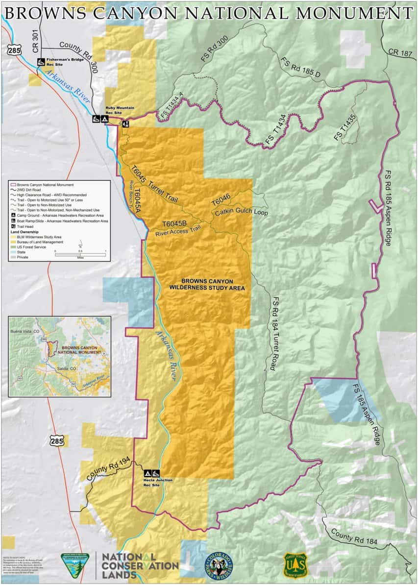
Similar to recent Federal legislative initiatives to release on WSAs, there are currently state-based pressures to remove roadless area protections. For example, Utah Governor Herbert recently petitioned the U.S. Department of Agriculture to revoke and rewrite the national Roadless Rule as applied to The Aspen Ridge Roadless Area provides a uniquely undamaged landscape with wilderness qualities. Utah’s forests to open these lands to development. (See https://governor.utah.gov/2019/03/01/utah-submits-request-to-the-department-of-agriculture-regarding-federal-land-maintenance and https://ourforests.utah.gov/wp-content/uploads/2019/02/UtahRoadlessRulePetition_28Feb2019.pdf.) In light of these known and anticipated pressures, as well as the need for clear management prescriptions to be outlined in the RMP for future agency officials, it is important for the USFS to consider proactive management to preserve the wilderness character of the lands within the Aspen Ridge Roadless Area, such as those suggested in the following recommendations.
2. Recommendations
• The USFS should use the current planning process as an opportunity to recommend wilderness for the entirety of Aspen Ridge Roadless Area within the monument.
• The USFS should include language in the RMP, providing commitment to manage the Aspen Ridge Roadless Area under the same protections even if the roadless area designation were to be removed.
Holy Smoke! The folks who wrote this either didn’t know that the FS and Colorado had spent a great deal of in developing our own State Roadless Rule and that that is currently the law of the land in Colorado, or are generally promoting Utah-phobia just for the heckuvit.
Anyway, I did think that the BLM’s use of the “online story map” was interesting, and the webinar. The webinar seems like a great idea so many people can easily participate. Maybe FS plans have something similar, but I have not been keeping up. Check it out!
Related news clip: http://www.chaffeecountytimes.com/free_content/bureau-of-land-management-update-packs-house-at-league-of/article_e78a5694-1c4f-11ea-8510-3b8d773a685e.html
Thanks Brian! I don’t get why people would say this stuff:
“Vieira disputed a claim put forward by a press release from Friends of Browns Canyon advocating public comment published in The Times in September which said that the proposed RMP would open up nearly all of the monument to mining, oil and gas extraction, new roads and other types of development.
“I couldn’t believe it,” said Diane Alexander of the story. “Was that just a joke or what?”
“I’m not familiar with that …, but all minerals were withdrawn from the National Monument as part of Proclamation 9232 (The presidential proclamation made by Barack Obama in 2015 which created the monument),” Vieira said. “So the minerals were withdrawn, there’s no oil and gas leasing allowed in Browns Canyon National Monument.””
Actually it reminds me of the type a and b behavior we were discussing on another thread. Some people like to get other people worked up by saying things that aren’t true, hoping that…?? Spreading fear to those who aren’t currently up on things because ??? Puzzling.. er… political..
Hi Sharon, I just came across your posts about the Browns Canyon National Monument (BCNM) Resource Management Plan (RMP) and Sustainable Alternative and felt the need to set the record straight, mainly regarding the terrible article you quoted from the Chaffee County Times. Most locals know not to believe everything they read in the Times, but their reporter has outdone himself in this Dec. 12 article.
First of all, the Friends of Browns Canyon press release published by the Times in September did not say that land in the national monument would be open to oil and gas drilling. That press release wasn’t even about the BCNM RMP, it was about the BLM’s Eastern Colorado RMP, which proposes to open BLM lands ADJACENT to BCNM to development.
Here’s a direct quote from the press release, which I just copied from the Times website: ‘Friends of Browns Canyon encourages everyone who enjoys our natural landscapes to submit comments about the proposed loss of protections for these public lands as described by the “preferred alternative” for the Eastern Colorado Resource Management Plan.’
The press release clearly states the RMP in question is for the overall Eastern Colorado region, not the national monument. Furthermore, two Friends of Browns Canyon board members attended the League of Women Voters meeting and immediately corrected the misinformation, further demonstrating how unreliable the Times is as a news source. In fact, the Times article also includes other errors. For example, the article calls the resource management plan a “recreation management plan.” It also states that the BCNM RMP is a revision of an existing plan from 1996, which is completely false. The national monument was designated in 2015, and the currently proposed RMP is the first-ever management plan for BCNM.
So your assumption that Friends of Browns Canyon “like[s] to get people worked up by saying things that aren’t true” and suggesting that the motive is to spread “fear to those who aren’t currently up on things” for political reasons is wrong on all counts.
While these are the most significant issues in your posts, there are others that I plan to address in a separate post to keep the length more manageable.
Thank you Joe for providing some very important context and corrections. I hope you will take the time to address other issues as well.
You’re welcome Matthew. I fully intended to follow up on my comments by pointing out additional problems with Sharon’s post and comments, but:
1. As a freelance writer, I’m essentially working without pay whenever I write comments for a blog.
2. I’ve now followed The Smokey Wire long enough to realize that, in spite of Sharon’s stated goal “to solicit broad participation from a cross-section of interests,” her posts demonstrate a definite bias to the right.
I’ll continue to follow this blog since it relates to my background and interests, and while I’d like to contribute to the conversation, I simply can’t afford to work for free.
It looks to me like the Forest Service is just along for the ride. The Pike-San Isabel NF website is mostly empty, but 1) they include it under “projects” (rather than planning), and 2) they refer to a 2012 “notice and comment regulation.” Since they are not revising this forest plan, there are really no choices to be made about their process. If they are changing any long-term management direction (which seems unavoidable), they must amend the plan using the 2012 Rule. It should look something like the planning for the San Gabriel Mountains NM in California -https://www.fs.usda.gov/nfs/11558/www/nepa/101660_FSPLT3_4648366.pdf