Forests and Wildfires in the West Over 2,500 Years

This graphic tells a fascinating story. It’s from a press release about a new paper, “What the extreme fire seasons of 1910 and 2020 – and 2,500 years of forest history – tell us about the future of wildfires in the West,” by Philip Higuera, Professor of Fire Ecology, University of Montana and Kyra Clark-Wolf, Postdoctoral Associate in Ecology, University of Colorado Boulder
Tue, October 17, 2023.

PODs and the Lolo plan revision

Potential Operational Delineations (PODs) have come to the Lolo National Forest at the same time it is embarking on revision of its forest plan.  Coincidence?  Fortuitous?  Let’s revisit PODs (again).

To create PODs, stakeholders are assembled and first tasked with drawing lines on a map. The lines correspond to places where fires can often effectively be stopped, like a ridge, river, road or burn scar.

Developed by the U.S. Forest Service, the PODs approach has been growing across the West since 2017. The framework is supported by a $100 million federal investment as part of the 2021 Bipartisan Infrastructure Law and is now being used by an estimated 109 national forests and regional partners. Following a series of workshops, POD lines have been drawn as of late June 2023 for all units in USFS Region 1, which includes all seven national forests in Montana.

Since one of the purposes of PODs is to provide opportunities for not suppressing wildfires, this article talks about the current unpopularity of that option.   It also talks about real-world tests with wildfires on the Tonto National Forest, where buy-in from local partners led to successful management of fires for resource benefits.  As the article’s title suggests, the author seems focused on the technology, but the article also acknowledges the forest planning questions.

This is clearly a planning process:  “If we’re ever going to get over the hump in fire management of being more proactive about allowing certain fires to burn and putting other fires out, you have to think about these things and plan for them before the fire happens.”  But while the Forest Service talks about collaborating with other landowners, they don’t seem to talk about including the general public.

And PODs will not be used only for emergency situations after fires have started, but “PODs can also inform where fuels are treated, like the shaded fuel break project on the Lolo National Forest.”  If that “informing” amounts to management direction that is different for different parts of a national forest then it needs to be in a forest plan.  (See the management differences in Table 4 from this post If they stop at something like a “probability of containment” rating, that could probably be treated as “information.”)

This article recognizes the barrier that existing plans may be to managed wildfires.

In general, federal, state and tribal land management plans are the law of the land that dictate the suite of options available to a fire manager. Even if PODs have been drawn and risk assessments completed, a land management plan will override any strategy suggested via the PODs process that conflicts with the plan’s prescribed approach.

If a plan has not provided for wildfires to be used for resource benefits (like the current Lolo plan doesn’t), PODs for that purpose would not be consistent with the forest plan.  So, what about the Lolo forest plan revision?

The Lolo is currently one year into a four-year revision process for its forest management plan. Once the revision is completed, Missoula District Ranger Stonesifer said, the forest will have a plan rooted in the best available science. So far, it is unclear if the revised plan will incorporate PODs.

It’s hard for me to see how they could NOT incorporate them.  Once they open the door in the forest plan to managed wildfires, they can’t avoid talking about the details of how that would be done, and once they start drawing PODs on a map, I don’t see how they could not include the public interested in the forest plan, nor avoid integrating this with other plan decisions and talking about the effects of these designations.  That is forest planning.

(And then, whatabout all those PODs that have already been drawn on other national forests outside of the forest planning process?)


UC Irvine scientists reveal what fuels wildfires in Sierra Nevada Mountains

Text from a press release. The open-access paper is here.


UC Irvine scientists reveal what fuels wildfires in Sierra Nevada Mountains

Irvine, Calif., Sept. 25, 2023 — Wildfires in California, exacerbated by human-driven climate change, are getting more severe. To better manage them, there’s a growing need to know exactly what fuels the blazes after they ignite. In a study published in Environmental Research Letters, Earth system scientists at the University of California, Irvine report that one of the chief fuels of wildfires in California’s Sierra Nevada mountains is the decades-old remains of large trees.

“Our findings support the idea that large-diameter fuel build-up is a strong contributor to fire severity,” said Audrey Odwuor, a Ph.D. candidate in the UCI Department of Earth System Science and the lead author of the new study.

Researchers have known for decades that an increasing number of trees and an increasing abundance of dead plant matter on forest floors are the things making California wildfires more severe – but until now it was unclear what kinds of plant debris contribute most to a fire.

To tackle the question, Odwuor and two of the study’s co-authors – James Randerson, professor of Earth system science at UCI, and Alondra Moreno from the California Air Resources Board – drove a mobile lab owned and operated by the lab of study co-author and UCI alumna Francesca Hopkins at UC Riverside, to the southern Sierra Nevada mountains during 2021’s KNP Complex Fire.

The KNP Complex Fire burned almost 90,000 acres in California’s Sequoia and Kings Canyon National Parks. In the fire’s smoke, the team took samples of particulate matter-laden air and analyzed the samples for their radiocarbon content at UCI’s W.M. Keck Accelerator Mass Spectrometer facility with co-author and UCI Earth system science professor Claudia Czimczik.

Different fuel types, explained Czimczik, have different radiocarbon signatures, such that when they analyzed the smoke they discovered radiocarbon values associated with large fuel sources like fallen tree logs.

“What we did was pretty distinctive, as we were able to identify fuel sources by measuring the wildfire smoke,” said Czimczik. “Our approach provides what we think of as an integrated picture of the fire because we’re sampling smoke produced over the course of the fire that has been transported downwind.”

The team also saw elevated levels of particulate matter that is 2.5 microns in diameter or less, which includes particles that, if inhaled, are small enough to absorb into the bloodstream.

The preponderance of large-diameter fuels is new in western forests. “We’re really in a situation that’s a consequence of both management strategies and climate warming since European-American settlement began in California,” Odwuor said. “These fuels are building up on the forest floor over periods of decades, which is not typically how these forests were maintained.”

It’s information that, according to Odwuor, could help California better manage its wildfires.

“The knowledge that large-diameter fuels drive fires and fire emissions – at least in the KNP Complex Fire – can be useful for knowing which fuels to target with fuel treatments and what might end up in the smoke from both wildfires and prescribed fire,” said Odwuor. “The idea is that because we can’t control the climate, we can only do our best to manage the fuels, which will theoretically have an impact on fire severity and the composition of the smoke.”

But the solution isn’t as straightforward as removing trees from forest floors, because, among other things, they provide habitat for wildlife. That, and “once you get them out, where do you send them? There are only so many mills in California that can handle all the wood,” Odwuor said.

Where the new knowledge could be helpful is with prescribed burns, wherein teams burn tracks of forest in a planned fashion with the aim of reducing the amount of fuel available for future wildfires.

“We’re hoping to build some urgency for these management strategies,” said Odwuor.

Royal Burnett: “The Environmentalists Have Won”

I participate in a wildfire discussion group that averages around 130 members, a significant number of whom are retired professionals. The focus of the group has been Michael T. Rain’s “Call to Action” — a systematic and organic strategy for ending the mismanagement of wildfire on our public forests that has characterized much of the past 35 years. One of the occasional contributors to this discussion is Royal Burnett. Here is his current perspective. BZ 

My name is Royal Burnett. I am retired CDF Battalion Chief with 31 years experience on California wildfires. At the time of my retirement in 1993 I was an ICS rated Type 1 Incident Commander, Type 1 Ops Section Chief and FBAN.

Since my retirement I have kept active in fire and fuels modeling and have worked with various committees to solve the wildfire/conflagration crisis that exists in California.

I’ve been on the mailing list for “Call to Action” early on and have commented occasionally.

It should be obvious to all by now that we have not only lost this round, but perhaps the entire fight.

I’ve watched and commented as the USFS burned millions of acres near my home in Redding, California. This summer we had one lightning storm in August here we are in late September and several of those fires are still burning… this in spite of two wetting rains and several nights of 90 percent humidty recovery. These fires would have gone out if the USFS crews had not re lit them.

There is no public out cry. There is no voiced protest from the timber industry. There is no protest from the Society of American Foresters.

What is more alarming is there is not protest from the Indigenous people whose ancestral homelands are routinely torched… the same people who have to live under choking clouds of smoke for months in Happy Camp and Hoopa.

As we speak the Blue and Copper fire are burning near Orleans in prime timber and the quote from the Forest Service Information says there “no values currently threatened”.

No Values ??? The environmentalists have won. Since the Spotted Owl was used to successfully shut down logging in Northern California an entire industry and culture was destroyed. Not only were the obvious logging jobs lost… the fallers, the skid operators the choker setters… the second tier jobs were lost.. the mechanics, the saw shops closed… and the third tier jobs in the cafes and other support services that fed the loggers and truckers and went away.

Several towns closed the sawmills that had provided employment for generations. That resulted in the loss of gas stations and grocery stores…all for an owl that was probably not threatened from the start.

We are now in the second generation of the collapse of the North Coast economy and the citizens and Tribal Leaders realize the only way to make living and remain in their homes is to kowtow to USFS. They now accept the annual huge wildfires…they sign on as truck drivers and timber fallers, the stores make sack lunches, the fuel trucks and porta potties get rented.. and our forests burn.

The USFS has completely reversed course. Fire used to be bad, now its good. I’ve seen the try to brand and sell their insane policy in many different ways…Let Burn… MIST…Light Hand on the Land…Burning for Resource Benfits…its all attempt to convince the public that they have not bungled the stewardship of our National Lands. Anyone with eyes can see that the miles of snags standing alongside the Highways leading in and out of Redding are not productive forest…not even as a Carbon Sink.

USFS Chief Randy Moore announced huge fuel management goals… going to treat millions of acres annually. Little did anyone realize that Moore was going to count acres burned in wildfire as treated acres. And, to go one step further… if a Forest Supervisor met the Fuel Management goals the that would count toward that individual getting an annual performance bonus.

A couple of the nearby Forests give lip service to aggressive initial attack on all fires… to going direct where possible… to working night shifts… this is all in response to public out cry to mismanagement of various incidents. In truth, when fires on those forest escape Initial Attack and USFS Team is called in and the Big Box is drawn on the map . There is no effort to keep that fire small…the objective is to burn as many acres as possible and count them as fuel treated acres…part of the fire resistant landscape .

When fires start in August and the first team in says estimated control date is December you’ve got to realize that something is dreadfully wrong.

The damage that’s been done to the forests and watershed in Northern California will take generations to recover…and there is no rehabilitation plan.

In the last 10 years I’ve watched on TV and live reports as thousands of Northern California homes and millions of acres burned. Many of those acres burned deliberately by the USFS under the guise of firefighter safety or creating fire resistant mosaics…that’s another lie. All they’ve done is create snag patches with and understory of mixed brush. They have increased, not decreased the fire hazard. I’ve watched while entire communities burned due to USFS Tactical and strategic mistakes and there was no review. I watched as hundreds of Giant Sequoias were killed in a backfire…and no one spoke up…not even Save the Redwoods League.

Recently the 10th Circuit Court supported USFS Sovereignty…granting them immunity from lawsuits and repercussions for damages caused to public and private property when allowing a fire to burn for yet to be determined resource benefits. Citizens can file tort claims, but have no say if the USFS deliberately burns their property ?

The USFS has become a leader in the Fire/Industrial complex that has a vested interest in burning our forest land. Its a sad , sad day when this once proud Agency has degenerated into a gang of the most prolific, the most persistent serial arsonists ever to plague our wildlands.

Conversations with Lars: Opinions & Predictions

For the past 11+ years I have been writing a series of article/editorials for Oregon Fish and Wildlife Journal, which has a circulation of 10,000 mostly rural Oregon businesses and residents and all Oregon elected officials. Several times I have used this forum to “peer review” the facts, analyses, and opinions that have comprised an occasional entry in the series. This is another one of those instances, and mostly focuses on two radio interviews I did with Lars Larson on his radio show this past summer.

The article draft is more than 3800 words and has six illustrations with captions, so I have only included a few of the illustrations and excerpted the mostly informative and provocative text in this post, angling for discussion. For those interested, I have posted the entire draft here — publication will probably be in a month or sooner: http://nwmapsco.com/ZybachB/Articles/Magazines/Oregon_Fish_&_Wildlife_Journal/20230923_Lars_Larson/Zybach_DRAFT_20230917.pdf

*******************

[October 12, 2023 UPDATE: The article has now been published in the current issue of Oregon Fish & Wildlife Journal. Publisher and editor Cristy Rein has noted that the magazine’s 10,000 circulation includes: “free magazines to every US Senator, all of the US Congress, the entire Executive Cabinet and committees, every elected state rep in: Oregon, Washington, Montana, Idaho, Nevada, California, Utah, Arizona and New Mexico.” Here is a link to the article, and including one-page editorials by Cristy and by Jim Petersen of Evergreen Magazine: http://nwmapsco.com/ZybachB/Articles/Magazines/Oregon_Fish_&_Wildlife_Journal/20230923_Lars_Larson/Zybach-Larson_20231010.pdf]

*******************

Conversations with Lars: Summer of ’23 Smoke & Fire

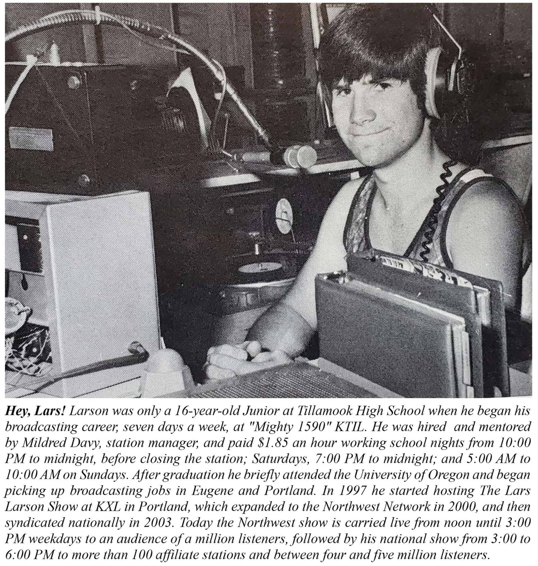
I’ve never met Lars Larson in person, but my first radio interview with him was about 20 years ago as I was finishing my graduate degree at Oregon State University. The questions likely had something to do with the Biscuit Fire at that time, or the Donato Study, which was in the news.

Since then we have had many more conversations on air, with discussions mostly focused on spotted owls, wildfires, forestry, or the Elliott State Forest. These are subjects of particular interest to me, and it’s always a pleasure talking to Lars — usually in nine-minute increments between commercials — given his own knowledge of these topics.

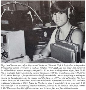
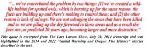
Because of Lars’ close familiarity with forestry, Northwest history, wildfires, and wildlife, his interviews are more like discussions or conversations than typical interviews. For that reason I decided to use the transcript from our recorded July 28, 2014 talk as the basis for an article/editorial in this series. The topic was the ever-increasing severity, frequency, and extent of Oregon catastrophic wildfires — as I had been clearly predicting for many years — and “climate change” as a possible cause. The article appeared in the Fall 2014 issue of this magazine, titled “Global Warming and Oregon Wildfire History,” and was generally well received.

This summer I had wildfire-related conversations with Lars on two of his shows. In July we discussed the smoke from Canadian wildfires polluting US air, and in August the topic was the deadly fire in Hawaii. Audio recordings of both interviews were critically well received by several national and regional experts in wildfire management and mitigation, and I decided to resurrect the 2014 format for this article.

***********************

July 7, 2023: SMOKE

Lars: Welcome back to the Lars Larson Show, it’s a pleasure to be with you, and I’m always glad to get to your phone calls and your emails. On this First Amendment Friday, we celebrate your first amendment rights of free speech, free expression, and the right to associate with anyone you want to associate with.

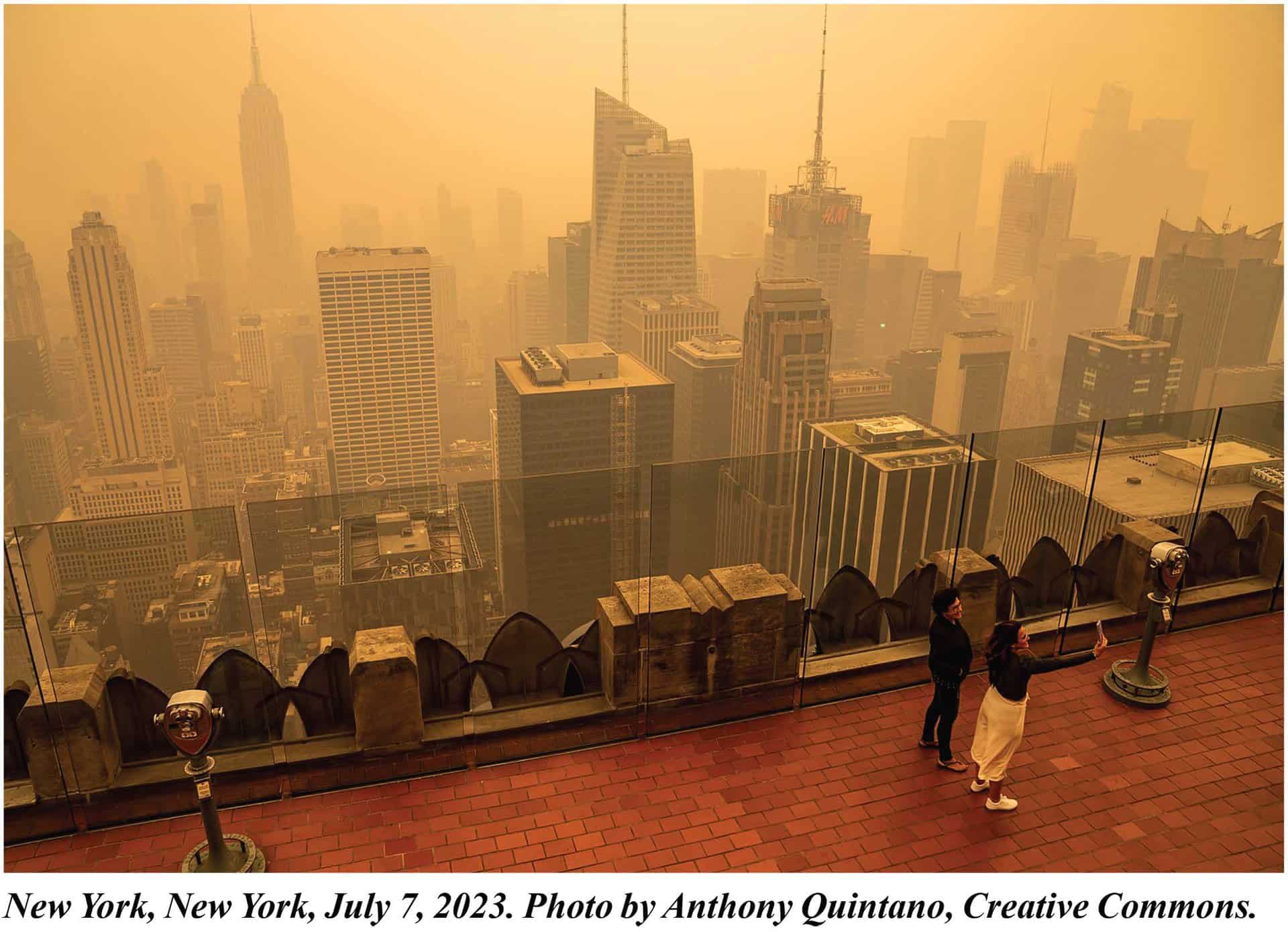
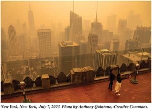
Now, I want to ask you about this. You’ve seen what happened when wildfire smoke got into New York City and all of a sudden, the elites were breathing that orange air, and you’ve seen the same kind of thing happen this year in Seattle, they’re breathing smoky air as well. And in recent history in the Pacific Northwest, we’ve seen plenty of occasions where the smoke went on for weeks and weeks and weeks.

Lars: I’m glad to have you here because I want you to prepare my audience. I know this summer we’re likely to get even more smoke in the Pacific Northwest. We’re going to have fires. We’ve gone from the 30-year period you talk about frequently from I think the mid-fifties to the mid-eighties where we had essentially no large fires in the forest. Thirty years of no large fires at all, and now routinely half a million acres burn in Oregon. Half a million acres I think, on an average year burn in Washington, and we’ll expect to have fires this year as well. And I know to a fair certainty, the people in charge are going to say, “Yep, it’s all evidence of global warming.” Help prepare them with some answers for those people who say those things to them.

Bob: Well, it’s all due to fuels and weather. Global warming hasn’t happened here, so it can’t be global warming. We’ve got the same weather we’ve had for centuries. Fire season is the problem. East winds are the danger. So with the Labor Day Fires three years ago, we had east winds in early September, so we had massive fires.

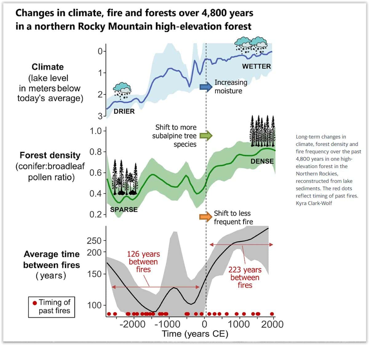
The real problem is managing the fuels. From ’52 to ’87 we had one major fire, on the Smith River in 1966. It was 40,000 acres. So that’s 30 some years with one major fire. It doesn’t even compare to the Labor Day Fires — on one day, where close to a million acres burned. The Coast Range doesn’t get lightning; Southwest Oregon gets lightning but doesn’t have a lot of people; and the Western Cascades gets lightning and has a lot of people. So once we get a heavy east wind, assuming we do, ignition can come from lightning or people and large fires are the result. And largely because of the massive fuel buildups on federal lands over the last 35 years.

Lars: Dr. Zybach, there’s one thing I hear the media do constantly and they say, “Wildfires get worse during hot times.” Is there anything about a day being either 80-degrees or 105-degrees that makes a difference in terms of fire?

Bob: It’s the east wind. You can have an 80-degree or 105-degree fire; maybe at 105 degrees, depending on fuel moisture, you could have a cleaner burn and easier to control by that measure, but it depends. The fire will create its own wind, will create its own weather. They can even create thunderstorms, the big fires. But an east wind is the constant element that goes with all the major fires in Western Oregon over the last few hundred years.

Lars: So when you see these fires, you’ve studied this subject, you studied 500 years of it, 1491 to 1951. Are there ways to get on top of this problem where we could prevent these fires instead of merely trying to put them out every year and usually succeeding only to the extent that we contain them to half a million acres; instead of maybe 10 or 20,000 acres a year on an average year in that period you documented from the fifties to the eighties?

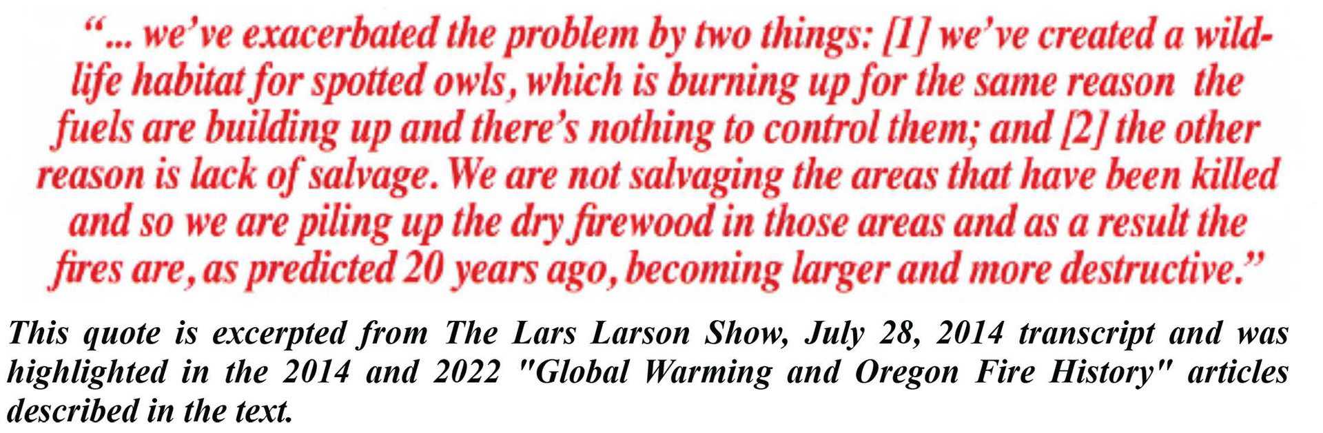
Bob: Yes, and it would be the same thing. It would be active management. Right now, the Forest Service and BLM are planning to leave all the snags and large woody debris. Jerry Franklin says a sign of a healthy forest is a lot of dead trees. That’d be like saying a sign of a healthy city is a lot of dead people. It doesn’t make sense. That’s not healthy. It’s a fuel and it’s dangerous.

So we used to harvest snags, dead trees, focus on it. We used to maintain the roads and trails and keep them open. We used to have local employment where local people that knew the roads and the land and the animals were the ones that were doing the logging and the tree planting and so on. And so we didn’t have fires. So we know how to mitigate these fires and that’s why they’re so predictable.

Like myself and others in the early nineties said, “If we create these LSRs and other government acronyms, we’re going to have massive wildfires and they’re going to kill wildlife and some people, destroy homes, and it’s going to be at a cost to rural communities that lose the work associated with forest management.” So we know how to fix the problem. We just don’t.

Lars: I’m just curious, do you have any insights as to why the people who followed you in forest science, I mean you’ve been in forest science for decades, why the people who are now coming into it seem to think that forests that burn on a regular basis or forests with lots of dead fuel on the forest floor are a healthy forest? Why the change?

Bob: Well, indoctrination. Eisenhower warned us that the government will get big computers and put independent scientists out of business. And essentially, if you cut to the chase, it’s anti-logging activists. A lot of people in the eighties and nineties thought that clearcutting was an evil. And so they picked spotted owls and marbled murrelets and coho as animals that they claimed — erroneously, still erroneously — were harmed directly by clearcutting, and got the lawyers in Washington DC and the lawyers on the ground to pursue that. And they’ve been very, very successful. And wildfires are the predictable result.

August 14, 2023: FIRE

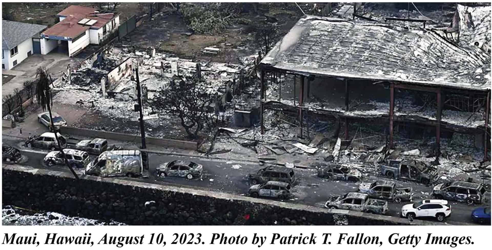
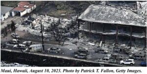
Lars:  Welcome back to the Lars Larson Show. It’s a Tuesday. It’s the Radio Northwest Network, and it’s my pleasure to be with you. And now we have the deadliest fire in US history in Maui and northwest communities under evacuation orders from wildfires. What has put us in this spot and how do we get out of it?

Lars:  I want to get your take initially about what happened in Maui because we’re now starting to see not just where the blame may go to power lines or other conditions like that, but almost everybody on the left politically says, oh, this is all about climate change. This is something that’s come on us because human beings use too many fossil fuels. Any truth to that?

Bob: None. It has got nothing to do with climate change. Everything to do with housing, exotic weeds, in the case of Hawaii; which is similar to Paradise and similar to the Almeda Drive fire in that weeds and housing that were very close together formed the primary fuels and in all three cases were deadly. People died because of the speed in which the fire moved.

Lars:  Well, and weeds in the case — I know when people hear weeds, they say well, everybody has weeds, but is it worse in places like Maui? Because as I understand, that used to be a big area for growing sugar cane and then sugar cane has gone away to a large extent, and as a result, there’s a bunch of land that’s not very well tended but it could be, couldn’t it?

Bob: Yeah, and it’s the same thing. Almeda Drive was weeds. They created a “Greenway” and it grew up in blackberries, and those blackberries are real volatile when they die and form a canopy, and that’s what happened there; that and a lot of trailer houses and a lot of weeds. In Hawaii it was weeds that grew up in the agricultural areas that had been abandoned or converted to housing and then the housing is essentially dead trees. It’s dried lumber that’s built the houses, and if they’re close together, there’s no way to make them “Fire Safe.” Each house is fuel for the adjacent house.

Lars:  And is part of the problem that in Lahaina especially, they called the place historic. It had a lot of buildings that went back before modern building codes. If they had said, well, even without building codes, we have to do something to keep these houses if one catches fire from spreading to the next one. This was all foreseeable and preventable. Am I wrong?

Bob: No, that’s exactly right. When we find — a wind will whip up in different directions. Here in Western Oregon, it’s from the east, and in Hawaii, I’m guessing it might be from any direction — but when weeds and fuels, volatile fuels, are adjacent to flammable buildings where people live, it’s a risk and we’re seeing the results of that risk.

Lars: Now, what about the Northwest communities? We’ve got a bunch of communities that they’ve gone to evacuation, mandatory evacuation. Are those also evidence that we’re not managing the forest and the wildlands very well and we could be?

Bob: We’re doing a terrible job there. These fires were predictable for the last 30 years. If we look at the Flat Fire right now, the heat isn’t a real problem. It means fuels burn cleaner and faster. But if a wind comes up, if a Chetco Wind comes up, an east wind comes up, we’re asking for another Silver Complex or Chetco Bar Fire, just a real disaster. And the way we can tell that is the Flat Fire. It’s well contained at about 33,000 acres that used to be called a major fire 20 years ago. Now it’s got to be a hundred thousand acres to be a major fire, but you look at the photos and it’s completely surrounded by snags from earlier fires. So these fires are just fueling future fires just like the Tillamook Fires in the 1930s and ’40s did. And it wasn’t until we removed the snags, took out the fuels and actively managed that land that we were able to create Tillamook Forest, and we’ve got the same problem in Curry County. They’re just allowing the snags to remain in place and fuel the next fire, and it’s been going on since 1987.

Lars: I’m talking to Dr. Bob Zybach, who’s a forest scientist and the president of Northwest Maps. The other thing is they don’t just allow the snags to stay there. Correct me if I’m wrong, but the “Greeny Groups” say, “No, you will not go in and salvage log. No, you will not take down those snags. That’s part of Mother Nature. We have to leave it there.” And they insist on leaving it there and not clearing the fuel and not replanting. I’ve seen that demand a number of times. And they could actually do that, and maybe even make the money to pay the cost of doing the replanting, couldn’t they?

Bob: Sure. We did that for 30 or 40 years. When we studied the Tillamook, we figured out if we salvage this material, we’re making money, we’re paying taxes, we’re training people, we’re keeping access roads open. And so from ’52 until ’87, we had one major fire, one fire in excess of 10,000 acres in Western Oregon. Now we have a fire that big right now that we’re holding and calling contained, or 56% contained. So it’s a problem that’s become exacerbated through mismanagement of our federal lands specifically, but now that’s being transferred over to our private and state lands as well. The Elliott State Forest, they have no plan to harvest any snags, so it’s just asking for a disaster at some future point.


A Three Sisters Wilderness Trailhead Information Station

Les Joslin at Green Lakes Trailhead information station.

By Les Joslin

Marv arrived on the Deschutes National Forest that summer of 1991 as Bend Ranger District recreation forester responsible for wilderness and trails—and, therefore, for me. At the end of my second summer, when I turned in my campsite and trailhead surveys, he asked me what I thought the district’s wilderness management effort needed most.

“A trailhead information station at the Green Lakes Trailhead,” I answered immediately and explained why.

“You’re right,” Marv agreed, and asked if I’d pioneer such a station five days a week the next summer. I knew the wilderness well, and was a natural for the job. Since I couldn’t be paid a federal salary, I’d work on a small contract. “We’ll build a portable station, and you’ll staff it and work out how it works next summer.” I agreed to this first unexpected opportunity to address my Forest Service presence concern.

Over the winter, as I designed a wilderness trailhead information program, Marv enlisted a high school shop teacher to supervise construction of a sturdy little one-room, board-and-batten sided, shake-shingled building atop a rugged two-wheeled trailer bed that I would open the coming summer of 1992 as the Green Lakes Trailhead Information Station. I signed a contract to provide visitor information services there on Wednesdays through Sundays for fifty days from July 2 through September 7 at $49.50 per day.

Cold and rainy July 2, 1992, proved an inauspicious opening day for the Green Lakes Trailhead Information Station temporarily based—since the station structure hadn’t been completed—on a log at the trailhead. But I stood my post and served 18 visitors that first day, nine of whom actually began trips into the Three Sisters Wilderness. The others just wanted information, mostly about other things they could do on the Deschutes National Forest on cold and rainy days. The bad weather persisted over that Fourth of July weekend during which I served an even two hundred visitors—177 who took day trips into the wilderness, four who began overnight trips, and the rest who sought general information.

As the summer advanced and the weather improved, visitor numbers increased and the range of trailhead services they needed became apparent. Most needed information about trail travel and camping. The knowledge I’d gained during two seasons of trail patrols and campsite surveys, along with a mounted map of the wilderness and the excellent Geo-Graphics Three Sisters Wilderness maps provided by the Northwest Interpretive Association for me to sell, made that a snap. More challenging was explaining wilderness regulations and the new self-issued wilderness permits. I knew the regulations and the reasons for the permits, and my public contact experience as a Toiyabe National Forest fire prevention guard during the 1960s helped an even more mature me address these topics successfully with a wide range of visitors of varying viewpoints. Most appreciated the presence of “a ranger” and the services he could provide. Some wondered why I didn’t have a ranger station. “It’s coming,” I told them.

And on July 30, the little Green Lakes Trailhead Information Station building arrived and was installed at the trailhead. I wasted no time affixing the mounted wilderness map to its front wall and moving in. The increased visibility afforded by the building and a local television news feature on the wilderness shot there on July 31 got my trailhead operation even more notice.

The next morning, August 1, I arrived at the trailhead station to find a single wheel track leading into the wilderness. I soon put this together with a vehicle in the parking lot marked “Pole Pak” and determined that the inventor and manufacturer of this one-wheeled device to aid backpackers—a good idea, perhaps, but not compliant with wilderness regulations that precluded wheeled vehicles (except wheelchairs)—was testing or using the device. I documented this and reported it to my supervisor.

Marv, perhaps afraid I’d get bored spending five days a week on trailhead duty—and not knowing that being bored was a waste of time I do not permit myself, arranged for one of the Student Conservation Association volunteers to staff the station on August 9 so I could patrol to Moraine Lake. On August 20, wilderness ranger Jill held the fort while I patrolled the Green Lakes-Soda Creek loop and swapped ideas with Don Doyle, the Deschutes National Forest wilderness coordinator.

Word about the trailhead station got around, and on August 28 Forest Supervisor Joe Cruz, District Ranger Walt Schloer, and a couple staff officers along with former wilderness manager Jim Bradley, a professional staff member on the Subcommittee on National Parks and Public Lands, U.S. House of Representatives, took a look. Might my project, I began to wonder, make a difference beyond the Deschutes National Forest?

Jim Petersen: What do environmentalists want? Also, the trouble with the Eastside Screens

Jim Petersen’s Op-ed – today in the Spokesman Review (pay-walled)

What do environmentalists want?

The litigation driven collapse of the Colville National Forest’s historically robust forest restoration and fuels management programs raises a seemingly unanswerable question.

What do litigious environmentalists want, not just in the Colville National Forest but in every national forest in the West?

More to the point, what do Tim Coleman and his Kettle Range Conservation Group want? Coleman’s group successfully sued the Forest Service to stop the Sanpoil forest restoration project, which was developed under the aegis of the 2004 Tribal Forest Protection Act in consultation with the Confederated Tribes of the Colville Reservation.
The court order signed June 23 by Judge Stanley Bastian, Chief District Judge of Washington’s Eastern District, sends Colville National Forest planners back to square one on a project that took years to plan.

Sanpoil proposed thinning and prescribed burning on about 18,000 acres over several years. Boise Cascade’s Kettle Falls mill bought the project – about 15 million board feet of timber including some harvestable trees larger than 21 inches in diameter.
This seems to be the crux of Coleman’s lawsuit. Never mind that the larger trees include shade tolerant grand firs that threaten younger ponderosas that are native to the Colville National Forest.

Grand fir is a thin-barked tree that is easily killed by insects and wildfire. It secured its foothold on the Colville during wetter than normal years in the 1950s and has continued to spread faster than it has been removed from forests in central and eastern Washington.

Grand fir – think Christmas trees – have very bushy low hanging branches that act as ladder fuels, allowing wildfires to climb into forest  canopies. Canopy fires kill almost everything in sight. Witness the Stickpin Fire, which destroyed 54,000 acres in the Colville National Forest in 2015.

Grand fir enjoys the protection of the 21-inch rule, a failed set of standards known as the Eastside Screens that the federal government imposed in 1994 to conserve old growth forests east of the Cascades in Oregon and Washington.  

The 21 inch screen requirement is failing because tree size and age do not correlate. Some tree species – in this case grand fir – grow much faster than other tree species – in this case native ponderosa pine.

Coleman and his Kettle Range Conservation litigants aren’t conserving anything. They pose a far greater danger to the Colville National Forest and its communities than forest restoration work ever has or will.

Among their harms: the water citizens drink, the oxygen that heathy forests release into the air we all breathe, critical fish and wildlife habitat, outdoor recreation opportunity and jobs in Northeast Washington, not just at Boise Cascade but also Vaagen Brothers, Columbia Cedar and several small logging companies whose payrolls support every other business in Stevens, Ferry and Pend Oreille county.

These counties have enjoyed a congressionally blessed working relationship with the Colville National Forest staff for many years. They have been strategic players in the success of the Northeast Washington Forest Coalition and its stakeholder partners – all contributors to several widely praised forest restoration projects.

Coleman is destroying the good work stakeholders are doing in Northeast Washington forests. Fortunately, Farm Bill conferees in Washington DC are considering 2024 revisions in the National Environmental Policy Act that would limit Coleman’s ability to destroy what the Forest Service and its citizen partners are trying to do.

Coleman’s wants and needs should not negate those of diverse publics that value green trees and healthy forests and communities.

Jim Petersen is the founder and president of the non-profit Evergreen Foundation, based in Dalton Gardens, Idaho.

Friday News Roundup: Firing Ops, Agency Appears to Say “No” to Congress, Mining Reforms, Changing Wildlife Behavior

Please add your favorites from the week in the comments below.

Firing Operations During the 2012 Dixie Fire

Firing operations are one of the main tools firefighters have at their disposal to corral large fires once they have escaped initial attack, but putting fire on the ground at the peak of fire season, often during the extended periods of drought which bring us megafires, is rarely anybody’s first choice. Often these operations take place in a ‘we had to try something‘ context. We are reprinting this article now, as firing operations rarely get much attention in the press, and the mechanics behind how they are conducted is at the core of how large fires get fought.

************************************************

Yesterday’s “Analysis Paralysis”; Today’s “Permitting Reform”

Can Agency Heads Really Do That? And What is the Rest of the Story?

If you haven’t been following the proposed NEPA regs… thank whatever Deities you believe in. It appears to be another “we’ll require lots more stuff to do, but it will be faster and more efficient.. because.. we say so!” effort.

I realize 100% that the House Natural Resources Committee is not an unbiased group, but I didn’t know agencies could simply do this.

CEQ Chair Brenda Mallory was invited to testify but declined to appear or send a designee to testify on behalf of the agency. This is yet another moment in which Mallory, and CEQ as a whole, has ignored a co-equal branch of government.

60 Recommendations for Mining Law Reform

This is probably worth taking a closer look at. Maybe folks can put links to stories in the comments. I’ll probably have to read the report (shudder) for something else I’m working on.

“This report represents months of interagency policy work and over 50 meetings with industry, environmental groups, labor unions and tribes across the country, following the President’s Day One Executive Order on strengthening America’s Supply Chains,” said Deputy Assistant to the President and Deputy Director of the National Economic Council Joelle Gamble. “Securing a safe, sustainable supply of critical minerals will support a resilient manufacturing base for technologies at the heart of the President’s Investing in America agenda, including batteries, electric vehicles, wind turbines and solar panels.”

The report provides more than 60 recommendations to Congress and federal agencies, including for increasing public and Tribal engagement, making permitting processes more consistent and predictable for industry, and protecting impacted communities and workers, as well as the environmentally and culturally sensitive lands they cherish. The report also identifies reforms to revitalize federal support for research into advanced, lower-impact mining and exploration technologies and methods, workforce development, and the need for increased resources to address the legacy of abandoned and unreclaimed hardrock mining sites that continue to pollute land and water throughout the country.

And what agencies can do:

In the near-term, the IWG report makes dozens of recommendations for federal agencies that can be undertaken without Congress, including that federal permitting agencies adopt identified best practices for engagement, with early and extensive engagement with applicants, agency and intergovernmental partners, and impacted communities and Tribes prior to the start of the formal environmental review process.  This can help alleviate conflicts and speed permitting reviews, while improving outcomes for public health and the environment. The IWG report also encourages exploration and mining companies to adhere to established best practices, such as beginning community and Tribal engagement at the earliest possible stage, providing financial support to allow communities and Tribes to hire independent technical experts, developing community and Tribal benefit agreements, and considering independent and transparent reporting of air and water pollution monitoring data.

Wildlife Corner

 Lions and Wolves and Bears..

This New Scientist story is paywalled so I posted more than usual

In Yellowstone National Park in the western US, the habitat of cougars (Puma concolor) – also known as mountain lions – overlaps with that of grey wolves (Canis lupus), grizzly bears (Ursus arctos horribilis) and American black bears (Ursus americanus). Today, these top predators compete for similar food sources like deer and elk, and often steal fresh kills from each other – but it wasn’t this way a century ago.

In the 1920s, cougars and wolves were eradicated from the national park and bears were a rare sight. Cougars have slowly recolonised the area in the last few decades and initially had an abundance of elk to feast on. But grey wolves were reintroduced to the park in the 1990s, adding another elk predator and triggering a cascade of ecological changes.

The number of grizzly and black bears in the park has also jumped in recent decades, creating even more competition for elk and similar prey. To see how this was influencing cougars, Jack Rabe at the University of Minnesota and his colleagues tracked 13 cougars in the area using GPS collars. Their analysis, presented earlier this month at a meeting of the Ecological Society of America, included 381 kills by the cougars – primarily deer and elk – from 2016 to 2022.

They found signs that bears had visited around 30 per cent of the cougar kill sites, probably scaring the cats off their kill. Wolves visited cougar kill sites less often, around 8 per cent of the time. “Bears are definitely much more effective at finding cougar kills,” says Rabe, which might be because there are more bears than wolves in the area.

The researchers could also compare their data with similar tracking data recorded two decades earlier. This showed that cougars are now hunting a greater proportion of their prey on rough landscapes, including rocky slopes and forests. “Cougars are definitely better hunters where the ambush territory is better,” says Rabe. The cats may be returning to the hunting strategy they relied on before the loss of other predators left an abundance of elk and deer for them to pick off in more open areas.

And Coyotes and Bobcats

I can’t access the original article in Science. But this excerpt from New Scientist is interesting.

To investigate, Laura Prugh at the University of Washington in Seattle and her colleagues tracked the movements of 22 wolves (Canis lupus), 60 cougars (Puma concolor), 35 coyotes (Canis latrans) and 37 bobcats (Lynx rufus) using GPS collars between 2017 and 2022. They followed the animals across two forested regions of Washington state punctuated by roads, ranches, homes and small towns.

When wolves and cougars moved into an area, bobcats and coyotes appeared to avoid the larger predators. They spent more time near the developed and human-populated areas that wolves and cougars typically avoid. But this move often had fatal consequences: around half of the coyotes and most of the bobcats that died during the five-year study period were killed by people.

“A few coyotes and bobcats were shot while trying to raid chicken coops,” says Prugh, and others were shot on sight or snagged in traps. They found that humans killed between three and four times as many small carnivores as the apex predators did.

Prugh says that earlier studies on small carnivores suggested a strong fear of people, “so from that perspective, we were a little surprised that they shifted more towards humans in the presence of large carnivores”. The discovery that human-populated areas were more deadly to small carnivores suggests the phenomenon known as the “human shield effect”, in which some animals seek refuge near people, can be lethally self-defeating.

Coyotes, mountain lions, and bears seem to do pretty well in many forested rural and semi-rural communities, at least around here, although there are certainly conflicts.

Mapping Fire Resilience Priorities: Communities and Carbon

This essay from The Conversation is interesting.  The author’s study is public access.

“The US is spending billions to reduce forest fire risks – we mapped the hot spots where treatment offers the biggest payoff for people and climate”

Excerpt:

To find the locations with greatest potential payoff for forest treatments, we started by identifying areas where forest carbon is more likely to be lost to wildfires compared to other locations.

In each area, we considered the likelihood of wildfire and calculated how much forest carbon might be lost through smoke emissions and decomposition. Additionally, we evaluated whether the conditions in burned areas would be too stressful for trees to regenerate over time. When forests regrow, they absorb carbon dioxide from the atmosphere and lock it away in their wood, eventually making up for the carbon lost in the fire.

In particular, we found that forests in California, New Mexico and Arizona were more likely to lose a large portion of their carbon in a wildfire and also have a tough time regenerating because of stressful conditions.

When we compared those areas to previously published maps detailing high wildfire risk to communities, we found several hot spots for simultaneously reducing wildfire risk to communities and stabilizing stored carbon.

Forests surrounding Flagstaff, Arizona; Placerville, California; Colorado Springs, Colorado; Hamilton, Montana; Taos, New Mexico; Medford, Oregon, and Wenatchee, Washington, are among locations with good opportunities for likely achieving both goals.

A Three Sisters Wilderness Trailhead Presence

Les Joslin collecting wilderness visitor data at Green Lakes Trailhead.
Les Joslin collecting wilderness visitor data at Green Lakes Trailhead entrance to Three Sisters Wilderness.

By Les Joslin

I made such a good start at those campsite surveys during 1990 that some of my Three Sisters Wilderness work during summer 1991 was focused on gathering information for a study about how visitors use and perceive wilderness. This put me in a position to meet about five times as many visitors as I had met the previous summer.

A trailhead—especially a heavily-used one—is a good place to contact wilderness visitors. There, where people begin and end wilderness visits, an appropriate Forest Service representative can do a lot of good. Visitors may be made to feel welcome—which they are—and provided useful information. Regulations may be explained. And violations of regulations—and thus, impact on the wilderness resource and the wilderness experiences of other visitors—may be prevented. And, in those days, permits—if required—could be issued.

I spent about a third of my wilderness duty days that second summer at the Green Lakes Trailhead, the most used Three Sisters Wilderness access point. There, for nine hours a day, I collected visitor use data through interviews and surveys, explained the new wilderness permit system instituted that summer, and answered questions.

That new wilderness permit resulted in the most questions. Yes, I answered, self-issued day-use wilderness permits—previously required in the late 1970s and early 1980s—were required from Memorial Day weekend through October. I likened these permits, for which there was no charge, to visit registrations. It was a softer word. Overnight permits were issued by forest officers.

One regulation, prohibiting use of mechanized equipment—including mountain bikes—in the wilderness, required frequent explanation. One day that summer, after explaining the wilderness idea to two young men with mountain bikes who wanted to follow two young women on horseback around the Fall Creek-Soda Creek loop trail, I explained how any form of mechanical transport—except wheelchairs—is incompatible with the legal and ethical definitions of wilderness. They accepted my explanation, and the map of Deschutes National Forest mountain bike trails I offered as an alternative.

“Have you ever seen a wheelchair in the wilderness?” one asked.

“No, I haven’t,” I replied.

But, as fate would have it, I did later that afternoon. A man and wife with two children, one a seriously handicapped toddler in a three-wheeled conveyance, arrived at the trailhead. The conveyance qualified as a wheelchair.

“We plan to go in for a night or two. It’ll be the kids’ first time,” the man explained. “We thought we’d try Green Lakes. What do you think?”

“Well, it’s pretty late in the day to start for the Green Lakes, especially with the children. And the weather forecast calls for storms in the Cascades tonight. If you’re going into the wilderness, I think you’d be better off going to Moraine Lake. It’s closer, easier to get to, and there’s more cover there.” I told him how to get there, and showed him on a map. The couple thanked me.

“Do you have an overnight wilderness permit?” I asked. At that time, overnight permits had to be issued by a forest officer.

“No. Guess we forgot to get one.”

“I’ll issue you a permit, and you can be on your way.”

And soon they were. I admired their determination to experience the wilderness with their children despite their young son’s condition.

It stormed that night.