Of Wolves and Wilderness

The following guest column was written by George Nickas, executive director of Missoula-based Wilderness Watch, and one of the nation’s leading experts on  Wilderness Act policy and management.  Please consider this opinion piece a follow-up to this January 8 post. – mk

Of Wolves and Wilderness
By George Nickas

“One of the most insidious invasions of wilderness is via predator control.” – Aldo Leopold, A Sand County Almanac

Right before the holidays last December, an anonymous caller alerted Wilderness Watch that the Forest Service (FS) had approved the use of one of its cabins deep in the Frank Church-River of No Return Wilderness (FC-RONRW) as a base camp for an Idaho Department of Fish and Game (IDFG) hunter-trapper. The cabin would support the hired trapper’s effort to exterminate two entire wolf packs in the Wilderness. The wolves, known as the Golden Creek and Monumental Creek packs, were targeted at the behest of commercial outfitters and recreational hunters who think the wolves are eating too many of “their” elk.

Idaho’s antipathy toward wolves and Wilderness comes as no surprise to anyone who has worked to protect either in Idaho. But the Forest Service’s support and encouragement for the State’s deplorable actions were particularly disappointing. Mind you, these are the same Forest Service Region 4 officials who, only a year or two ago, 
approved IDFG’s request to land helicopters in this same Wilderness to capture and collar every wolf pack, using the justification that understanding the natural behavior of the wolf population was essential to protecting them and preserving the area’s 
wilderness character. Now, somehow, exterminating those same wolves is apparently also critical to preserving the area’s wilderness character. The only consistency here is the FS and IDFG have teamed up to do everything possible to destroy the Wilderness and wildlife they are required to protect.

Wilderness Watch, along with Defenders of Wildlife, Western Watersheds Project, Center for Biological Diversity, and Idaho wildlife advocate Ralph Maughan, filed suit in federal court against the Forest Service and IDFG to stop the wolf slaughter. Our suit alleges the FS failed to follow its own required procedures before authorizing IDFG’s hunter-trapper to use a FS cabin as a base for his wolf extermination efforts, and that the program violates the agency’s responsibility under the 1964 Wilderness Act to preserve the area’s wilderness character, of which the wolves are an integral part. Trying to limit the number of wolves in Wilderness makes no more sense than limiting the number of ponderosa pine, huckleberry bushes, rocks, or rainfall. An untrammeled Wilderness will set its own balance.

The FS’s anemic defense is that it didn’t authorize the killing, therefore there is no reviewable decision for the court to overturn, and that it was still discussing the program with IDFG (while the trapper was in the field killing the wolves). Unfortunately, the district judge sided with the FS and IDFG, so we filed an appeal with the Court of Appeals for the Ninth Circuit. Rather than defend its action before the higher court, Idaho informed the court that it was pulling the trapper out of the Wilderness and would cease the program for this year. In the meantime, nine wolves are needlessly dead.

We will continue to pursue our challenge because the killing program will undoubtedly return. The Forest Service can’t and shouldn’t hide behind the old canard that “the states manage wildlife.”  Congress has charged the FS with preserving the area’s wilderness character and the Supreme Court has held many times that the agency has the authority to interject itself in wildlife management programs to preserve the people’s interest in these lands. Turning a blind-eye is a shameful response for an agency that used to claim the leadership mantle in wilderness stewardship.

Wilderness Watch expresses its deep appreciation to Tim Preso and his colleagues at Earthjustice for waging a stellar legal battle on our behalf and in defense of these wilderness wolves.

George Nickas is the executive director of Wilderness Watch. George joined Wilderness Watch as our policy coordinator in 1996. Prior to Wilderness Watch, George served 11 years as a natural resource specialist and assistant coordinator for the Utah Wilderness Association. George is regularly invited to make presentations at national wilderness conferences, agency training sessions, and other gatherings where wilderness protection is discussed.

Selective Harvest as a Balanced Approach?

I have come across a web ad several times in the last week or so. Against a forest-stream photo background, the ad text reads, “Balance at last for our OC lands?” OC meaning the 2.4 million acres of Oregon and California Railroad (O&C) lands managed by the BLM in Oregon. Clicking on the ad leads to The Coalition for Our O&C Lands, http://oclands.org. Its members include green groups, fishing and river-guide services and groups, along with assorted others, including, for what it’s worth, “Chef Kim Reid.”

What Does Balance Mean? The coalition says Vibrant Economies, Responsible Timber Harvest, Clean Water, Land & Water Protections. “Responsible Timber Harvest” means selective harvesting, rather than clearcuts:

A balanced approach on O&C lands, while including protections of special places, clean drinking water and wildlife habitats, must also include responsible timber harvest. Timber is an important contributor to our state’s economy and any plan for the O&C lands should recognize that reality.   

For decades in the Northwest, we clearcut our ancient forests, believing that we could reestablish our forests and the species that lived there.  As we learned more and realized more of the damaging impacts that our actions had on our forests, wildlife, and clean water, we learned to change.  We can harvest more selectively and preserve habitat while still economically harvesting trees.   Responsible timber practices can ensure a predictable, sustainable supply of timber and forest products while also protecting our natural heritage.  We have examples of these types of practices throughout the state and we need to replicate them on the O&C lands.

The great thing about our timber industry is that it is adaptable.  It is managed by people who care for the land.   Many of them are hunters and fishermen.  They enjoy the outdoors and cherish the wild areas of our state.  They want wildlife to flourish and clean water for everyone to drink.  The industry has adapted to severely reduced timber harvests and survived.  But there is a better way to manage our timberlands, somewhere between “no harvest” and “clearcutting.”  Working together, we can find that careful balance.

At the end of the day, any plan must ensure a predictable, sustainable supply of timber and other forest products to help maintain the stability of local and regional economies, and contribute to supporting healthy, vibrant communities.

I’ve lately heard several green-leaning folks suggest that selective harvesting would work perfectly well on the O&C lands and elsewhere in western Oregon. Maybe so, if an economic return is low on your priority list. What do you think?

John Leiberg Reports on SW Oregon “Natural Fire Regimes” in 1899

Last February I posted a somewhat lengthy discussion of lodgepole pine bug and fire history that included several quotes from John Leiberg’s 1899 report titled “Cascade Range Forest Reserve from Township 28 South to Township 37 South, Inclusive, Together With the Ashland Forest Reserve and Forest Regions from Township 28 South to Township 41 South, Inclusive, and from Range 2 West to Range 14 East, Willamette Meridian, Inclusive”: https://forestpolicypub.com/2013/02/28/lodgepole-pine-ecology-1899-2013/

A more comprehensive selection of his observations in this report can be found here: http://www.orww.org/History/SW_Oregon/References/Leiberg_1899/

Several of these quotes were also posted as a Comment about a week ago, but WordPress won’t let me search those files or list more than 18 of my past comments for some reason, so I am reposting them here, based on current discussions of wet vs. dry forests, natural fire regimes, and wildfire severity patterns and history.

Leiberg was a Swedish immigrant who did much of his botanical field work from his base near Lake Pend Oreille, in Idaho Territory, including the 19th and 20th annual reports of the US Geological Survey, which encompassed most (or all) of the current Bitterroot National Forest. He was meticulous in his observations, including counting the tree rings of several tree species at small sawmills that had just entered the region (“virgin forests”), and using land surveys, photography and personal interviews to build detailed maps and tables for several different forested areas in the western US, mostly in Oregon, Washington, Idaho, Nevada, Montana, and Minnesota.

I believe him to be one of the very best forest scientists of his era for these regions, but his work has been sadly neglected — likely beginning with the politics surrounding the formation of the National Forests in 1906 and the transfer of the Forest Reserves for the Department of the Interior to the Department of Agriculture. It was to Pinchot’s advantage to ignore Leiberg’s work because it directly contradicted his assertions that the federal reserves were not being properly studied or managed. Leiberg died in Leaburg, Oregon (near Eugene) in 1913.

I would be very interested in the thoughts of other Commenters on this blog regarding the following quotes:

(p. 245) The duration of the forest type is indefinite.  While undoubtedly subject to evolutionary changes, its modifications or transitions to other types are so slow as to be quite imperceptible to us.  Not so with subtypes, They frequently change, sometimes two or three times in a generation.  Forest fires are fertile causes for inducing such rapid changes.  But even when left undisturbed a subtype rarely persists in any particular locality for more than 250 or 300 years.  Such at least is the rule on the eastern and immediate western slope of the Cascades and in the basins between the Cascades and the Rocky Mountains.  The only exception to this rule in the region named that is known to me occurs in pure yellow-pine and western-juniper growths. 

(p. 248) But the open character of the yellow-pine type of forest anywhere in the region examined is due to frequently repeated forest fires more than to any other cause.

(p. 249) The forest floor in the type is covered with a thin layer of humus consisting entirely of decaying pine needles, or it is entirely bare.  The latter condition is very prevalent east of the Cascades, where large areas are annually overrun by fire.  But even on the western side of the range, where the humus covering is most conspicuous, it is never more than a fraction of an inch in thickness, just enough to supply the requisite material for the spread of forest fires.

(p. 268) In other places fires have destroyed a certain percentage of the forest.  The damage may vary from 10 to 60 per cent or higher. The destruction has not been all in one place or body.  The fire has run through the forest for miles, burning a tree or group of trees here and there.

(p. 274) The age of the timber utilized in sawmill consumption varies from 100 to 350 years.  Most of the yellow pine falls below 175 years; the higher limit is reached chiefly in the sugar pine.  Most of the sugar pine in the region is of great and mature age.  Comparatively little red fir is sawn.  It varies in age from 100 to 500 years, and some of the very large individuals seen were doubtless even older.  The noble fir and white pine of mill-timber size varies in age from 100 to 350 years, most of it falling below 180 years.  The alpine hemlock of mill size runs from 80 to 250 years, 120 to 140 years representing the age of the bulk of the standard growth.  The white fir, with sufficient clear trunk development to come within the limit of these estimates, varies in age from 75 to 120 years.

(p. 277) The aspect of the forest, its composition, the absence of any large tracts of solid old-growth of the species less capable of resisting fire, and the occurrence of veteran trees of red fir, noble fir, white pine, alpine hemlock, etc., singly or in small groups scattered through stands of very different species, indicate without any doubt the prevalence of widespread fires throughout this region long before the coming of the white man.  But, on the other hand, the great diversity in the age of such stands as shown clearly their origin as reforestations after fires, proves that the fires during the Indian occupancy were not of such frequent occurrence nor of such magnitude as they have been since the advent of the white man.

(p. 277) The age of the burns chargeable to the era of Indian occupancy can not in most cases be traced back more than one hundred and fifty years. Between that time and the time of the white man’s ascendancy, or, between the years 1750 and 1855, small and circumscribed fires evidently were of frequent occurrence.  There were some large ones.  Thus, in T. 37 S., R. 5 E., occurs a growth of white fir nearly 75 per cent pure covering between 4,000 and 5,000 acres.  It is an even-aged stand 100 years old and is clearly a reforestation after a fire which destroyed an old growth of red fir one hundred and five or one hundred and ten years ago.  A similar tract occurs in T. 36 S., R. 5 E., only that here the reforestation is white pine instead of white fir.

(p. 277) The largest burns directly chargeable to the Indian occupancy are in Ts. 30 and 31 S., Rs. 8 and 9 E.  In addition to being the largest, they are likewise the most ancient.  The burns cover upward of 60,000 acres, all but 1,000 or 1,100 acres being in a solid block.  This tract appears to have been systematically burned by the Indians during the past three centuries [ca. 1600 to 1855].  Remains of three forests are distinctly traceable in the charred fragments of timber which here and there litter the ground.

(p. 278) Along the summits of the Cascades from Crater Lake to Mount Pitt are very many even-aged stands of alpine hemlock 200 to 300 years old.  These even-aged stands may represent reforestations after ancient fires dating back two hundred and fifty to four hundred years, but there is no certainty on this point.

(p. 278) It is not possible to state with any degree of certainty the Indian’s reasons for firing the forest.  Their object in burning the forest at high elevations on the Cascades may have been to provide a growth of grass near their favorite camping places, or to promote the growth of huckleberry brush and blackberry brambles, which often, after fires, cover the ground with a luxuriant and, to the Indian, very valuable and desirable growth.  The chief purpose of the fires at middle elevations and on the plains or levels probably was to keep down the underbrush in the forest and facilitate hunting.

(pp. 282-283)  There is little doubt that a very large proportion of the many rocky level tracts which occur east of the Cascades in the region under consideration are wholly due, as to the character of their present surface, to frequently repeated fires.  The pumice originally laid down at the bottoms of shallow lakes would be evenly spread out.  As the lakes were being gradually drained thick masses of marsh vegetation would preserve the pumice surface from wastage.  The marsh vegetation was finally supplanted by forest; then man came on the scene and with fire as an ally made some profound changes.  The entire series of phenomena here detailed, not omitting the part played by fire, are in full operation at the present time in the region bordering Klamath Marsh, and in various other localities, such as Sycan Marsh and tracts bordering the Klamath lakes.

(p. 288) These grassed-over places are, and have been, of commercial importance since the upper plateaus and summits of the Cascades began to be utilized as sheep pastures.  All of these pastures and meadows which owe their origins to fires are merely temporary affairs. If suffered to remain undisturbed by further fires they will return to forest cover.  Around Diamond and Crater lakes the grassy places are slowly giving way to stands of lodgepole pine as the primary reforestation.  On the lava plateaus flanking the crest of the range in Ts. 34 and 35 S., R. 5 E., grassy places created by fires before the advent of the white man have, in course of time, become covered with thick stands of lodgepole pine, now mature and giving way to stands of noble fir and alpine hemlock.

p. 290-291) The custom of the Indians of peeling the yellow pine at certain seasons of the year to obtain the cambium layer which they use for food, is in some localities a fruitful contributory cause toward destruction of the yellow pine by fire.  They do not carry the peeling process far enough to girdle the tree, but they remove a large enough piece of bark to make a gaping wound which never heals over and which furnishes an excellent entrance for fire.  Throughout the forests of the Klamath reservation trees barked in this manner are very common.  Along the eastern margin of Klamath marsh they are found by the thousands.

(p. 298) The southern and central portions are covered with stands of lodgepole pine, all reforestations after fires and representative of all ages of burns from one hundred fifty years ago [ca. 1750] up to the present time [1899].  There is no portion of these or the heavier stands of alpine hemlock and noble fir in the northern sections of the township that have not been visited by fire within the past forty-five years [since 1855].  Reforestations consist wholly of lodgepole pine as the first growth.  In some places on warm southern declivities brush growth comes in after fires.  In other localities a grass and sedge sward covers the ground.  It is clearly evident that many of the fires have been set for the purpose of promoting these grass growths and enlarging the possible sheep range.  It is also noticeable that wherever fires have been kept down for four or five years there is gradual return to forest and a disappearance of the grass.

(p. 305) This region [T. 29 S., R. 5 E.] was burned periodically during the Indian occupancy, as the many different ages represented in the lodgepole pine stands prove.  But when the white man came into the region the areas in this particular township was covered with a uniform stand of the species.  During the past forty or forty-five years [1855-1899] the timber has been burned in many locations and the subsequent reforestations have again been burned.  The region is too high in altitude to permit the growth of much brush.  After a fire one of three things happens: either lodgepole pine comes in as the first forest growth, or grasses and sedges form a thin, interrupted sward, or the ground remains bare of all vegetation.  It is impossible to predict beforehand which one of the three phases will appear.

(p. 395) The forest is of the alpine-hemlock type throughout [T. 35 S., R. 5 E.] .  Fires of modern origin have ravaged it extensively.  The great burns which cover the eastern areas of the adjoining township and wrought great havoc among what must have been heavy stands of noble fir.  The forests in the eastern areas have suffered no less, and there are scant signs of reforestation.  Most of the young growth now standing is overwhelmingly composed of lodgepole pine.  The bottom and eastern slopes of the South Fork Canyon have escaped fairly well and carry a forest in a state of tolerably good preservation.  Much of it has not experienced a fire for 300 or 400 years,  and in consequence it contains a vast amount of litter, consisting chiefly of the original lodgepole pine growth which followed a fire that occurred between three and four centuries ago [ca. 1500 to ca. 1600]. The lodgepole pine has had time to mature, die, and fall down, and a new forest 150 years old has taken its place since that time.

(p. 457) The Pokegama Lumber Company operates here, sending the logs to their mills at Klamathon, on the southern Pacific Railroad, by way of the Klamath River.  They cut pine exclusively, and cut all pine clean as they go, leaving great accumulations of debris behind them for future fires.  They take all trees far into the crown, trimming off the limbs and making the last cut on a basis of 7 to 8 inches in diameter at the small end.  In consequence they realize about 40 per cent higher yield than the customary cruisers’ estimates provide for.


Dwight D. Eisenhower: Science Research Visionary

In about 1955 or 1956 President Dwight D. Eisenhower came to Portland, Oregon for some reason or another. At that time I was attending Fernwood Grade School in NE Portland and our teacher walked us down to Sandy Blvd., where Eisenhower drove by in a convertible as he was traveling from the new airport to someplace downtown to meet with other politicians, waving to the crowd. Our teacher thought it was a great experience for us, but at that age the President was not as popular with us kids as Heck Harper, a local cowboy with a Saturday morning cartoon TV show, or Mr. Moon, who had a similar show and later got busted for being a pedophile. TV was a real fad among young Americans at that time, similar to how Twitter or iPhones are perceived today. However, some of my classmates soon began to wear “I Like Ike” pins on their shirts and most of the rest of us were kind of envious because we couldn’t afford such buttons, and because our parents didn’t have — and couldn’t give us — any.

Forty years later I finally read his “beware of the military-industrial complex” speech and came to realize it had a “Part 2”: “beware of government funded science” that really struck home with me, and explained a lot of what concerned me regarding scientific research and academic rewards at Oregon State University as I was completing my graduate research studies:

“In this revolution, research has become central, it also becomes more formalized, complex, and costly. A steadily increasing share is conducted for, by, or at the direction of, the Federal government.

“Today, the solitary inventor, tinkering in his shop, has been overshadowed by task forces of scientists in laboratories and testing fields. In the same fashion, the free university, historically the fountainhead of free ideas and scientific discovery, has experienced a revolution in the conduct of research. Partly because of the huge costs involved, a government contract becomes virtually a substitute for intellectual curiosity. For every old blackboard there are now hundreds of new electronic computers.

“The prospect of domination of the nation’s scholars by Federal employment, project allocations, and the power of money is ever present – and is gravely to be regarded.

“Yet, in holding scientific research and discovery in respect, as we should, we must also be alert to the equal and opposite danger that public policy could itself become the captive of a scientific-technological elite.”

— Dwight Eisenhower, Farewell Address, January 17, 1961

History of the Federal Sustained Yield Units?

Folks, an acquaintance has asked for help in finding information about the 6 Federal Sustained Yield Units established under the Sustained Yield Forest Management Act of 1944. I know a little about the Lakeview unit, the only one that still exists, I think, but nothing of the others. What happened to the others — Vallectios, Flagstaff, Grays Harbor, Big Valley, Shelton? Anyone know of a paper or article that looks at these as a group?

Forest Restoration: Problems & Opportunities in Words & Pictures

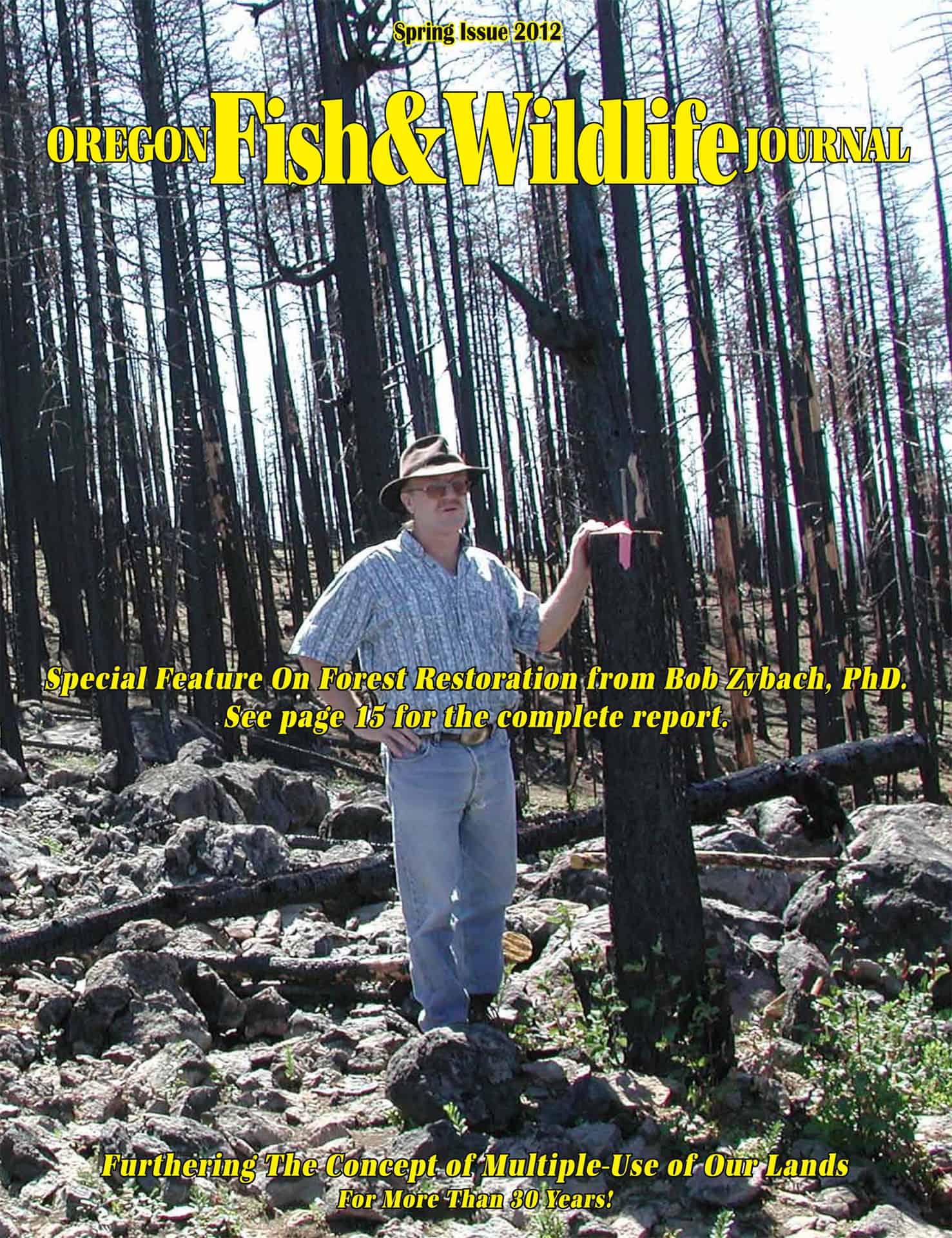
I am reposting this article from two years ago, but in its entirety, rather than as just a link. The main reason for reposting this is because of current discussions regarding “forest restoration” by newer participants on this blog, but it is also a good illustration as to how much the discussion dialogue and civility has improved here since that time. All of the photographs are by me except the cover photo, which is by Nana Lapham of Oregon Websites and Watersheds Project, Inc. The maps are by me and by Terrie Franssen of the Douglas County, Oregon Surveyor’s Office. The circulation of Oregon Fish & Wildlife Journal is about 10,000: mostly rural families and forestry-related businesses and urban outdoor sportsmen. It is not a peer-reviewed journal, but rather a popular magazine intended for “furthering the concept of multiple-use of our lands for more than 30 years.” WordPress does a poor job of duplicating illustrations from PDF files, so clearer versions of these maps and photographs can be found here: http://www.nwmapsco.com/ZybachB/Articles/Forest_Restoration_2012/
Zybach_2012a-1
Zybach_2012a-2a
Actively managing our western forestlands on a landscape-scale can immediately create thousands of rural jobs, greatly reduce catastrophic wildfire risks and damages, return millions of dollars to our state and federal treasuries, increase native wildlife populations, fund our rural schools, roads, and libraries, and make our forests and grasslands safer and more beautiful than ever before. Seriously.

Western forestlands have never been in worse shape: millions of acres of dead and rotting trees; thousands of miles of abandoned and barely maintained roads; record wildfires becoming larger, deadlier, and more destructive by the year; hundreds of artificially impoverished rural communities; and endless litigation preventing the use of resources we need to sustain our lives and our economy.

There are a number of reasonable ways to resolve these problems; a long-term commitment to active forest restoration and management seems to offer the most immediate benefits to both people and wildlife, and is the likely route to economic sustainability as well.

What is forest restoration, why is it needed, and how is it done are the questions addressed in this article. Two examples of current forest restoration projects are profiled to help answer these questions, and illustrate how these types of programs can be immediately implemented across the landscape to the benefit of neglected forests and depressed timber-producing communities throughout the West.

What is Forest Restoration?

The process of forest restoration is focused on returning an area to one reflecting desired past conditions, it is critical to understand a) what conditions were actually like in the past, and b) which of those characteristics (if any) should be restored or preserved for the future.

For the past 10,000 years and longer, Native Oregonians have used plants and animals for their own purposes: principally for food; shelter; fuel; and fiber products, such as clothing, basketry, musical instruments, canoes, ropes, and weapons. Fire was used for a wide range of purposes: for cooking, heating, and lighting areas around homes and campgrounds; for rejuvenating berry patches and harvesting fields of grain; for hunting game by systematically setting vast tracts of land on fire.

Man is the only animal that can use fire, but he is not the only animal that benefits from it. The expert and judicious use of fire across the ancient landscapes of Oregon resulted in the stable patterns of forests, woodlands, vast prairies, wetland meadows, brakes, balds and berry patches encountered by Oregon Trail immigrants in the 1840s and 1850s. Elk, deer, songbirds, fish, squirrels, migratory fowl, and other animals that populated these environments were documented by many of the new residents.

Forest restoration, means restoring people to the land, whether in the woods, along a river, or walking through a town. Restoring people to the land also supposes restoring fire to the land; fires set by people, not lightning.

Upper South Umpqua Project: Considering Past Conditions is Step 1.

The maps shown in this article represent a critical step in the forest restoration process – a determination and documentation of likely past conditions for areas being considered for restoration. Whenever we plan to restore something, it is important we understand the conditions that existed in the past.

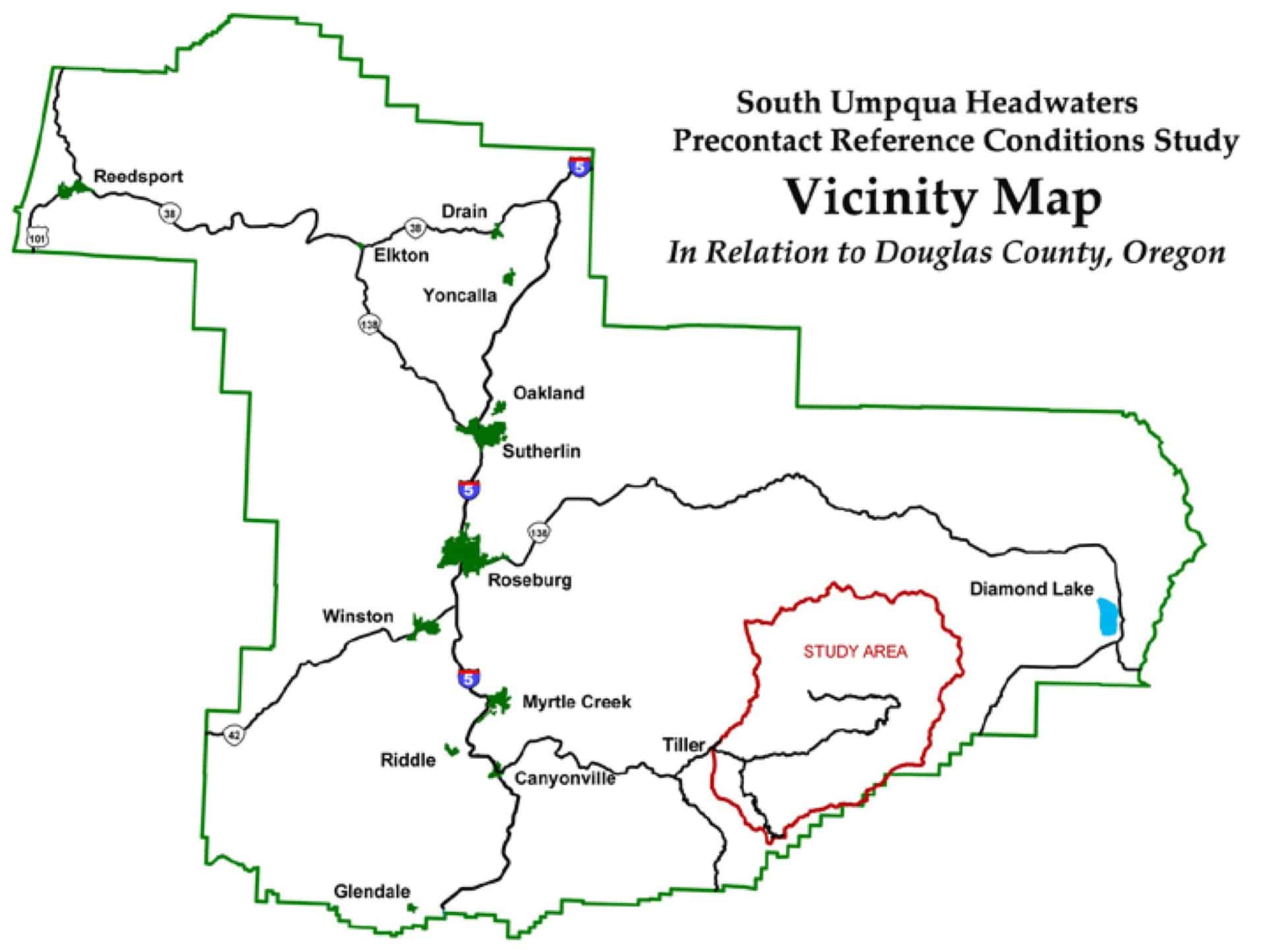
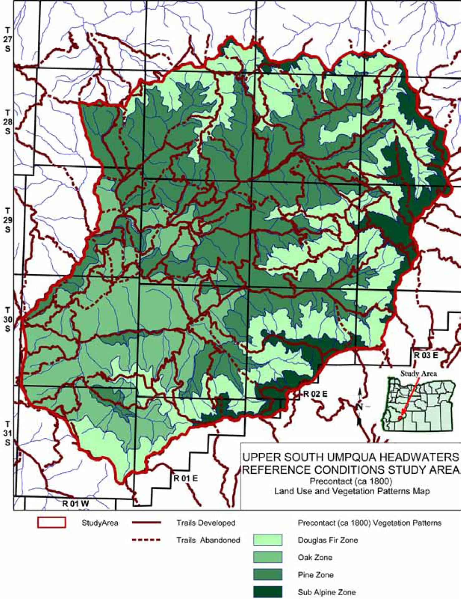
The “Upper South Umpqua Headwaters Precontact Reference Conditions Study” focused on characterizing a significant portion of the Umpqua National Forest in Douglas County, as it likely existed in 1825. The study area is slightly more than 230,000-acres in size and extends from the crest of the Cascade Range westward to the confluence of Jackson Creek with the South Umpqua River. The map shows the location and composition of forest type patterns as they likely existed in the study area 200 years ago. Each of the subsequent four photographs documents a typical example of each of the four forest types, and illustrates potential forest management actions needed to restore and maintain desired future conditions.

Zybach_2012a-2

Zybach_2012a-3
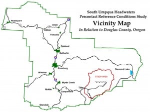
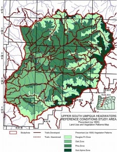
Map: Forest Type and Trail Patterns, 1800-1825

One of the basic purposes of forest restoration is to reduce wildfire risk and damages. The method for achieving this in overstocked stands of conifers is to significantly reduce their biomass (“fuel load”) and open up the tree canopies (“thinning”) as they existed in earlier times, when catastrophic-scale crown fires were uncommon occurrences. On federal lands this is referred to as an “FRCC 1” condition.

The Upper South Umpqua Project was initiated by Douglas County Commissioner, Joe Laurance, to consider the possibility of restoring degraded local forestlands to presettlement condition. On July 15, 2010, he testified to a Congressional subcommittee of The House Natural Resources Committee in Washington, DC:

“Fire Regime Condition Class (FRCC) 1 is similar to the forest which European explorers first found here. That forest had been modified by fire for more than six thousand years to provide the native inhabitants with what were then life’s necessities. These included abundant wild game from the most productive and diverse wildlife habitat ever known on this continent. Similarly, the regular burning of competing vegetation permitted propagation of nut bearing trees and other food producing plants. Additionally, the historic “Healthy Forest” promoted pristine rivers, streams, and lakes that provided an abundant harvest of fish and waterfowl. Within FRCC 1 the risk of losing key ecosystem components to fire is low, while vegetation species composition, structure, and pattern are intact and functioning within the natural historic range.”

Research methods used to determine and document 1825-era forest conditions in the study area included extensive use of General Land Office survey maps and notes, historical maps and photographs, field plots, oral history interviews, literature reviews, archival research, and over 5,000 GPS-referenced digital photographs. This latter method documented the location and extent of remaining old-growth (pre-1825) trees in the study area, in addition to documenting persistent patterns and patches of such traditional cultural food and fiber plants as camas, fawn lilies, cat’s ears, huckleberries, hazelnuts, chinquapin, tarweed, serviceberry, wokas, bracken fern, thimbleberries, and salal.

Historical research has given us the map shown: a generalized depiction of likely forest conditions in the study area during the 1800-1825 time period. The following four photographs represent current typical conditions within each of the four forest types (or “zones”) shown on Map 4. The large size and wide spacing of the older trees in the photographs can be gauged by the “human scale” used to measure them: Nana Lapham, long-time forest science research assistant of NW Maps Co., did much of the field work on this project.

Zybach_2012a-4
Photograph 1: Oak Type. Former oak and pine savanna.

Photograph 1 shows relict trees from an oak and pine savanna that was developed and used by native residents for hundreds or thousands of years. These areas were tended by constant gathering of fuel, acorns, and pine nuts from the trees and regularly tilling and/or burning the surface area to manage understory crops, such as camas, tarweed, hazel, and beargrass. Notice how Douglas-fir have invaded the area in the past 100+ years, threatening the survival of the few remaining old-growth oak and pine.

Zybach_2012a-5
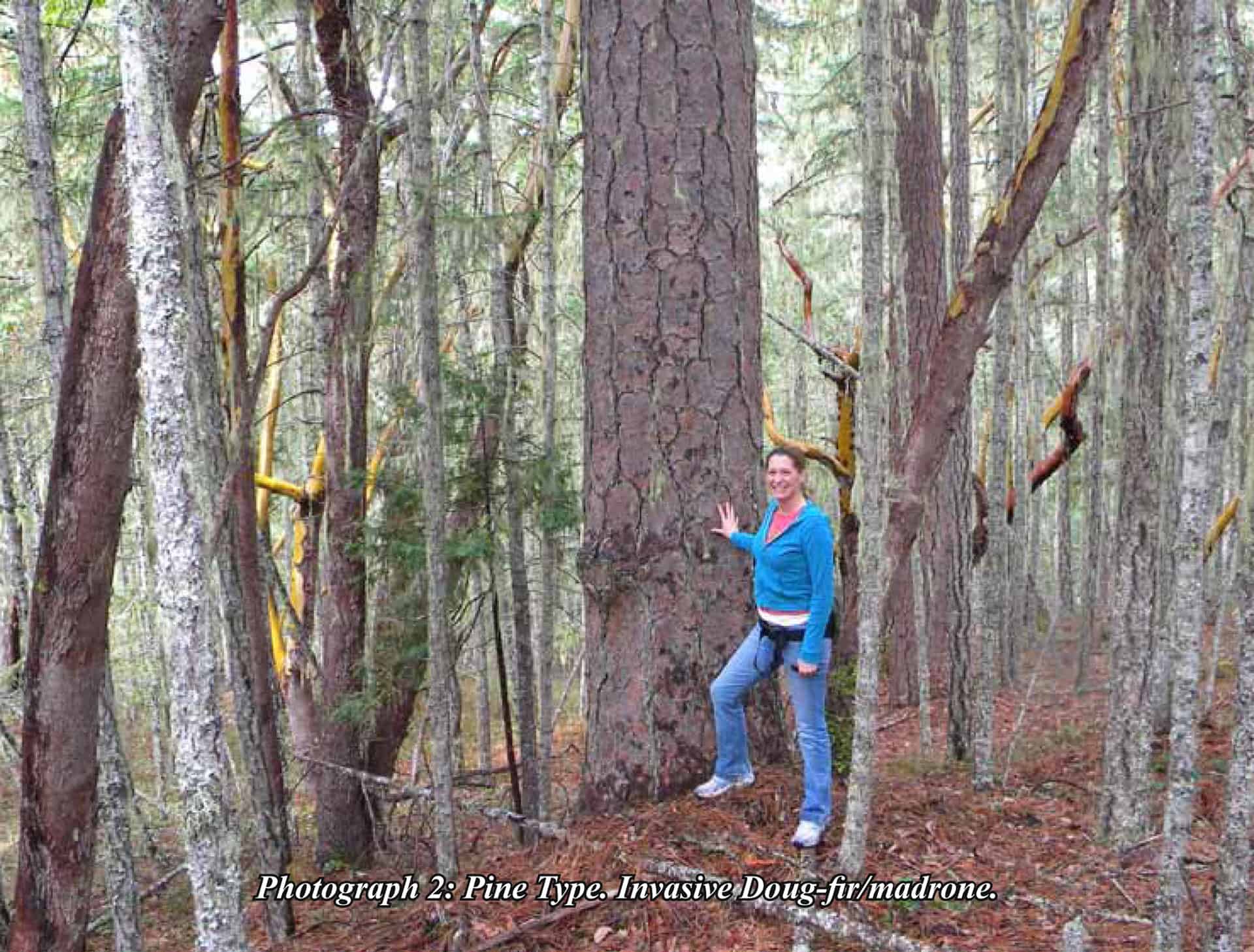
Photograph 2: Pine Type. Invasive Doug-fir/madrone.

Photograph 2 is a typical condition found throughout the former Pine Type in the study area. Again, these areas were maintained by regular prescribed fires in precontact time, and continuous canopy of fine, pitchy fuels. A crown fire under these circumstances would likely kill all of the trees in this picture, including the old-growth.

Restoring this savanna would entail removing the Douglas-fir, before they smother the remaining old-growth, removing the surface fuels that have built up around the bases of the oaks and pines, and reintroducing the understory plants and regular burning practices that created and maintained savanna conditions in the first place. There are thousands of acres similar to this throughout the study area, with invasive Douglas-fir slowly killing the established old-growth and creating potential crown-fire conditions by developing a are now being threatened by thousands of invasive Douglas-firs and madrone.

Zybach_2012a-6
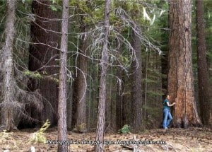
Photograph 3: Doug-fir Type. Douglas-fir/pine mix.

Photograph 3 shows the 1825 Douglas-fir Type, which still contains scattered old-growth sugar and ponderosa pine; species which may have dominated this type in the Indian era. Restoration provides the best option for prolonging the lives of these historic trees, too.

Zybach_2012a-7
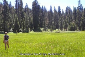
Photograph 4: True Fir Type. Huckleberry Lake.

Photograph 4 is a picture of Huckleberry Lake, in the high elevation True Fir Type. The “lake” is now a wetland prairie. This area used to be a portion of a major huckleberry gathering complex, equally accessible to Indian families living in the Rogue River and South Umpqua basins before these plants were shaded out by the invading conifers. The taller trees in the background represent larger diameter, older trees likely dating to the 1600s and 1700s; the vast majority of trees, though, having established themselves after the mid-1800s and throughout the 1900s.

The common theme throughout these maps and photographs is that tens of thousands of acres of old-growth oak, pine, Douglas-fir, red cedar, and other conifers exist throughout the study area are in need of immediate attention, if they are to survive. The same problem exists for the scattered patches of huckleberry, camas, tarweed, and native grasses that still persist. A forest is, ideally, composed of many facets, housing many different types and species of plants and animals. Those are the types of attributes that used to define these lands, and the same types that can be restored and maintained for future generations of people and wildlife.

Jims Creek Project: Make a Choice and Then Do It is Step 2.

The second step to forest restoration, is to determine what future conditions are desired and to begin actively restoring and/or maintaining those desired conditions across the land. An excellent example of this step is the Jims Creek forest restoration project on the Middle Fork Willamette Ranger District, which is in the process of completing an initial 400-acre “demonstration project” portion of a 25,000-acre plan.

The Jims Creek project has demonstrated the feasibility, profitability, and general benefits of conducting landscape-scale forest restoration projects on federal forestlands, but it is also a good example of how much time can be spent in putting these projects together, as well as the ease and quickness with which they can be stopped by adversarial legal actions. This project was initially conceived by a local US Forest Service forester/project manager, Tim Bailey, who then spent the better portion of the next ten years shepherding his vision through the myriad public meetings, scientific reviews, committee presentations, promotional tours, and other hurdles needed to get things underway on the ground.

Zybach_2012a-8
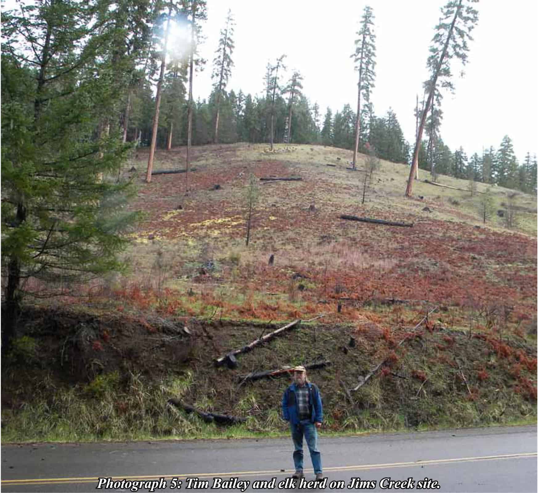
Photograph 5: Tim Bailey and elk herd on Jims Creek site.

Picture 5 shows Bailey in front of a portion of the Jims Creek Project in 2010. This area had already been treated by removing most of the invasive conifers established during the past century, and by broadcast burning the ground so as to remove excess litter and logging debris. Note the scattered trees that have been left behind: widely spaced pine of several different age groups, from seedlings to saplings and second-growth to old-growth. Also note the small herd of elk grazing directly above Tim, near the crest of the hill.

Zybach_2012a-9
Photograph 6: Close-up of 15-16 elk in restored prairie.

Picture 6 is the same herd of elk as the previous picture, seen through a zoom lens. The small charred stumps and large woody debris in the foreground will soon rot away or be consumed in the next few surface fires. The reddish-brown pattern is bracken fern, a plant harvested in large quantities by many Oregon tribes for its starchy roots and asparagus-like “fiddleheads” that grow in the spring. In a few more years, with a few more broadcast burns, this area will appear very similar to what it must have looked like hundreds of years ago.

Additional restoration has been halted at this time due to an infestation of red tree voles (“tree mice”) that accompanied the migration of Douglas-fir trees into the project area during the past century. These rodents are protected against logging under a federal “survey and manage” regulation, despite the fact they are not a threatened or endangered species.

This type of work stoppage, based on new federal regulations and litigation initiated by environmental organizations, has become the main difficulty in beginning and completing forest restoration projects in Oregon and throughout the West. Of the 25,000 total acres of this project within the Middle Fork Ranger District, 7,000 acres are privately owned and managed for maximum timber production; more than 7,000 acres have been classified as spotted owl habitat; approximately 7,000 acres are in remote areas that would likely include the “taking” of spotted owls; and the remaining 4,000 acres are populated with regulated tree voles. A river flows through the project area that contains two listed fish species and “there is a perception on the part of the regulatory agencies that this type of restoration work can have a negative effect on fish.”

Despite these hurdles, there is a lot of work needing to be done and a lot of people wanting to do it.

Conclusions

Forest restoration projects should be conducted on a landscape-scale basis in order to be effective biologically, aesthetically, and economically. Project boundaries should include sufficient commercial materials to treat the project area and show a profit. Profitable and beneficial actions are sustainable on a long-term basis, as we have learned from more than 10,000 years of forest history in this region.

The actions needed to restore our forests to earlier, more desirable conditions would create thousands of jobs for decades, jobs to make the best use of our resources, protect our old-growth and its wildlife, and greatly reduce the likelihood and severity of wildfire when they did take place. Based on my own experiences and observations, I think there are four things that must be in place for forest restoration projects to be successful on a long-term basis:

1) Areas slated for restoration should include sufficiently broad boundaries and specifications to allow projects to be profitable;

2) Restoration projects should be landscape-scale (25,000 to 250,000 acres) in size in order to be economically efficient and biologically effective over time;

3) Local residents and businesses should be in strong support of restoration projects, and be given access to all information that develops during the process;

4) Local project managers should be knowledgeable and capable of communicating scientific, technical, and political aspects of a project to local citizens.

I remain certain that the adoption of these practices, as defined, would have many immediate and positive effects on forest health, old-growth preservation, endangered species protection, rural economies, international trade balances, and many other economical, ecological, cultural, historical, aesthetic and recreational values associated with Oregon’s forests.

The degradation, destruction, and loss of our federal forests and grasslands to wildfire, bugs, and disease will continue to escalate so long as we continue our current path of passive avoidance and neglect. Restoring our Nation’s forests means restoring people – in part, as active managers – to our lands. The benefits for doing so have been listed; the impediments to getting started have been largely self-inflicted, are almost entirely political (rather than scientific or humanitarian), and can be readily surmounted, given effective leadership or common outcry. The best time for doing something is now.

Tribal Forestry and The Anchor Forest concept – Is it Appropriate for our National Forests?

This is from the Bellingham Herald

Some pertinent quotes include:

– “They call this concept Anchor Forest because this is tribal land — these people are not going anywhere. They’ll be here forever,”

– “Tribal goals of managing forests in perpetuity provide a foundation of sustainable management for the wider region”
– ““The tribes, we’re here. These are resources that we depend upon,” Rigdon said. “The type of fires that we are starting to see, those risks are real and can have a huge detrimental impact on the things the tribes value.”Large, intense wildfires are evidence of unhealthy forests, McGee said. The forests of this region were once adapted to frequent, low-intensity wildfires. But decades of fire suppression have allowed fuel to build up and small trees to grow in dense, flammable stands.These crowded conditions reduce the health of trees, giving insects, such as the spruce bud worm, the perfect opportunity to spread and damage, or kill, trees.”

– ““The goal is not to cut trees based on what sawmills need,” McGee said. “We need sawmills aligned with products that come off the projects that are doing good ecological restoration.”

The Yakamas own the only remaining sawmill in the region. It employs about 200 people, Rigdon said, and supports more jobs in the tribe’s forestry program.

A key part of the Anchor Forest plan, Rigdon said, is a study to determine how much wood should be coming off the region’s forests so the tribe and others can develop a market for those timber products and plan investments in new sawmill equipment or to build a pellet plant, for example.”

– “Karen Bicchieri, who manages the Tapash, says everyone involved wants the same thing — resilient forests.”

– ““In working together to improve the health of the ecosystem, we’ve got to be balanced and do it in a way that is beneficial from a social standpoint to build and sustain communities,” Blazer said. “When you bring (the tribes’) traditional knowledge with Western science, you can really develop strong forest management. There’s lots to learn from each other.””

To me this is what our National Forests should be all about.

An Oregonian’s Plan for Federal Forests: Untying the Gordian Knot

I have been a friend and business associate of Wayne Giesy’s for more than 25 years. During that entire time he has discussed with me – and anyone else who will listen – his ideas for resolving the conflicts surrounding the management of our nation’s forests; and particularly those forests in the western US.

During the past 30 years conflicts between the timber industry and environmental activists regarding the management of our federal lands have become so well known they are commonly referred to as the “Forest Wars”: a conflict in which opponents have taken sides in regards as to whether our federal forests should be actively managed principally for economic benefit of local and national interests, or whether they should be allowed to “function naturally” for intrinsic values and not necessarily be subjected to harvesting at all. These conflicts are not peculiar to just the western US, but have also been taking place in other countries, too, such as Brazil, Venezuela, Australia, and Tasmania.

Wayne’s proposed solution, commonly known as the “Giesy Plan” for many years because of its principal authorship, is to divide the lands into two parts: one to be managed for multiple use – with an economic focus — along more traditional lines, and the other to be managed in accordance with environmental concerns. The former approach would be subject to existing state and federal laws and regulations regarding riparian areas, road construction, etc., and the latter would allow for whatever harvests were needed to maintain forest health, recreational uses, wildlife habitat, and other environmental concerns. These separate approaches would be taken for an 80-year period to fully test them out, and then reconsidered at that time based on existing results and perceptions.

This “Oregon Plan” has been discussed in many venues and with many individuals – industrial foresters, tree farmers, politicians, and environmentalists — over the past 30 years (Wayne is now in his mid-90’s), and modified accordingly as it was being considered. Most recently Wayne met with Oregon Governor John Kitzhaber in a one-to-one meeting and was encouraged by the Governor’s thinking on the federal forest management issue. They discussed how changing the current management paradigm in ways that better achieve balance across all interests might obtain support not just within Oregon, but also as applied across all federal forestlands nationwide.

Is this the solution to resolving past conflicts and moving forward with the management of common resources? A growing number of people and organizations on both sides of the table seem to think so.

http://www.orww.org/Awards/2013/SAF/Wayne_Giesy/Oregon_Plan/index.html

The Oregon Plan

Untitled

Nick Napier, Dave Rainey, Wayne Giesy, and Bill Hagenstein at the Portland Wholesale Lumber Association’s 2010 annual meeting in Portland, Oregon. Wayne has promoted his idea for improved management of Oregon’s federal lands to forest industry, environmental organizations, and elected officials for the past 30 years, during which time it has become known as “the Giesy Plan.”

Sometime in 1983, after Wayne Giesy first began work as an employee of Ralph Hull, of Hull-Oakes Lumber Co. in Dawson, Oregon, Wayne approached Ralph with his concerns on increasing environmental actions to restrict logging activities on federal lands. At that time Wayne thought, in order to secure a stable supply of logs from BLM O&C Lands — where Hull-Oakes then obtained most of its raw materials — a deal should be made between the forest industry and the environmental organizations to divide the disputed lands into two portions: 1/2 for environmental purposes and 1/2 for public product needs (see: Giesy 2008a). After nearly a year considering this idea, Ralph gave Wayne the authorization and encouragement needed to present this idea to other forest industry leaders, with full backing of Hull-Oakes Lumber Co.

When Wayne first presented his idea to a number of forest industry leaders he was openly laughed at, and accused of “giving away the farm” by other members of these groups who couldn’t conceive of the environmental organizations having enough power or credibility to obtain such a major commitment of public resources. At that time local loggers and sawmill owners had access to perhaps 85% of the standing federal timber in Oregon; today that number is much closer to 15%, as the remainder has been dedicated to “critical habitat” for Threatened and Endangered Species, riparian “reserves,” Wilderness, roadless areas, and other designated “set asides.”

Wayne’s idea first became publicly known through an editorial written and published by long-time and well-respected Albany Democrat-Herald editor, Haso Herring, in May 2003. Although Herring’s editorial focused more on Wayne’s suggestions on how to deal with salvage from recent western Oregon Wildfires rather than a basic division of all federal lands, he used the name “Giesy Plan” to label Wayne’s thoughts: “The Giesy plan sounds visionary because it is based on common sense and assumes that obstacles can be overcome. That’s the way most Americans used to think. Would that more of us did so now.”

Today the name “Giesy Plan” is used more often to represent his original proposal, as it had been used for some time prior to the Herring editorial. Although its influence is generally not recognized or acknowledged in ongoing debates regarding the same problems that existed 30 years ago, current proposals strongly mirror Wayne’s original proposed suggestions and certainly have their basis in his unvarying advocacy. During the past two years, for example, there has been significant political discussion concerning the need to resolve the long-standing debate between forest industry and environmental groups in regards to the O&C Lands in western Oregon. Every one of these efforts has focused on a division of public forestlands between competing timber production, environmental preserves, and riparian reserves — as first suggested by Wayne in the early 1980’s, and as actively advocated by him ever since. Current examples follow:

In 2012 Oregon Governor John Kitzhaber formed an O&C Lands task force to address the problem of those forests to meet their federally mandated obligations. On February 6, 2013 the task force released a 96-page report that offered a series of options — each based upon Giesy’s principal suggestion that the lands be divided between the opposing factions and managed according to their individual perspectives. A series of graphs on page 46 of the report illustrated each of the proposed options, each one being based on Giesy’s basic argument to divide the land between resource production and forest preservation:

Also in 2012, Oregon Congressmen Peter DeFazio, Greg Walden, and Kurt Schrader developed a proposal, integrating the Kitzhaber report and based on the same concept developed by Giesy regarding the division of federal forestlands. The resulting proposed legislation, called the DeFazio-Schrader-Walden O&C Bill, was included by fellow Congressman Doc Hasting as part of the successful House Bill 1526. It has been generally supported by western Oregon members of the forest industry, but opposed by numerous environmental organizations, such as Oregon Wild, a long-time activist group based in Eugene, Oregon.

Simultaneous to Governor Kitzhaber’s efforts and those of Oregon’s bipartisan Congressional team, Oregon Senator Ron Wyden — initially working with fellow Oregon Senator Jeff Merkley — has been fashioning a separate solution to the western Oregon O&C Lands stalemate, generally referred to as “the Wyden Bill.” Senator Wyden’s efforts began in 2011 and are based on a “legislative framework” he developed that features as its basis: “The legislation will create wilderness and other permanent land use designations whose primary management focus will be to maintain and enhance conservation attributes. This acreage will be roughly equivalent to lands designated for sustainable harvest”; i.e., the same approximate 50/50 split first suggested by Giesy moere than 30 years ago, and actively promoted to the Senator, his staff, and many others ever since. Wyden’s proposal was publicly released on November 26, 2013, and was immediately opposed by most environmental organizations, such as Oregon Wild, and by the major western Oregon timber industries in a co-sponsored press release. On the following day the American Forest Resouce Council — which generally favored the DeFazio Bill — released a more critical response through their monthly AFRC Newsletter.

A more detailed look at the Giesy Plan — and the need for corrective management of federal lands in Oregon and in the remaining western States — illustrates the basic dependency of the Kitzhaber O&C Report, House Bill 1526, and the Wyden proposal on Wayne’s original concerns and recommendations:

Page 1. Proposes a division of US Forest Service lands in the 11 western states as: 40% for environmental concerns; 10% for riparian protection; and 50% “to produce products for the American public,” with certain conditions and restrictions. Ten “benefits” of adopting this idea are also listed, including: rural jobs, elimination of county payments, reduced imports, improved international balance of payments, reduced wildfire risk, enhanced wildlife habitat, and an elimination of  existing “negative activities” by both sides of the debate.

Page 2. Offers modifications to the original proposal, following consultations with both environmental and timber management proponents, with management divisions being made along watershed boundaries.

Page 3. A 2010 report using Oregon Department of Employment figures, showing 72,000 jobs lost in Oregon from 1989-2008 due to reduced forest management levels; and compared to 88,000 Oregon government jobs created during the same time period.

Page 4. A graphic comparison of the relative amounts of federal land contained in each of the eleven western states as compared to federal land holdings in the 37 eastern states (Hawaii and Alaska are not shown).

Page 5. Two graphs depicting the increasing trends of both total wildfire acres burned annually in the US, and for average size of each wildfire during the 1960-2006 time period: with sharp increases in both trends beginning in the early 1990s.

Page 6. A bar graph comparing Net Growth of US Forest Lands compared to Product Removals for the same lands during the 1952-2004 time period: 52 years in which forest growth has always exceeded harvests, and in which the greatest disparities between the two correlate strongly with the increased wildfire trends shown on Page 5.

Cal Fire Under Fire: Ordered to Pay $30 Million to Landowner

This article was published in Today’s Sacramento Bee regarding Superior Court Judge Leslie Nichols’ order for Cal Fire and the State of California to pay $30 million to Sierra Pacific Industries for damages related to the 2007 Moonlight Fire. I’ve posted the first several paragraphs; the link to the complete article follows.

Smoke rises from the Moonlight fire, which burned in Plumas and Lassen counties for 22 days in September 2007. Photo courtesy of the Office of the US Attorney.

Judge orders Cal Fire to pay $30 million for ‘reprehensible conduct’ in Moonlight fire case

By Denny Walsh and Sam Stanton
[email protected]
Published: Wednesday, Feb. 5, 2014 – 9:41 pm

In a blistering ruling against Cal Fire, a judge in Plumas County has found the agency guilty of “egregious and reprehensible conduct” in its response to the 2007 Moonlight fire and ordered it to pay more than $30 million in penalties, legal fees and costs to Sierra Pacific Industries and others accused in a Cal Fire lawsuit of causing the fire.

The ruling is the latest twist in an epic legal battle that began not long after the fire erupted on Labor Day 2007, scorching more than 65,000 acres in Plumas and Lassen counties.

Sierra Pacific, the largest private landowner in California, was blamed by state and federal officials for the blaze, with a key report finding it was started by a spark from the blade of a bulldozer belonging to a company working under contract for Sierra Pacific.

But company officials have steadfastly denied responsibility and have accused the California Department of Forestry and Fire Protection and the U.S. Forest Service of conspiring to cover up their own shortcomings that allowed the fire to rage out of control.

Even after Sierra Pacific agreed to settle a federal lawsuit over the devastation in two national forests by paying $55 million in cash and handing over 22,500 acres of land to the government, the company insisted it was undone by an erroneous ruling of U.S. District Judge Kimberly J. Mueller, and then was a victim of stonewalling by Cal Fire in that agency’s Plumas County suit, including the alleged withholding of thousands of pages of key internal documents relevant to the legal struggle.

In a 28-page order issued Tuesday, retired Superior Court Judge Leslie C. Nichols essentially agreed with all of Sierra Pacific’s points, adopting a separate, 57-page order proposed by Sierra Pacific and the other defendants almost word-for-word, and excoriating the behavior of Cal Fire and two lawyers from the office of Attorney General Kamala Harris, which represented the agency.

“The court finds that Cal Fire’s actions initiating, maintaining and prosecuting this action, to the present time, is corrupt and tainted,” the judge wrote. “Cal Fire failed to comply with discovery obligations, and its repeated failure was willful.”

The agency withheld documents for months, “destroyed evidence critical (to the case) … and engaged in a systematic campaign of misdirection with the purpose of recovering money from (Sierra Pacific).”

(Click link below for remainder of the article.)


Call The Bee’s Denny Walsh, (916) 321-1189.

Read more here: http://www.sacbee.com/2014/02/05/6132239/judge-orders-calfire-to-pay-30.html#storylink=cpy

Risk vs. Reward

risk

Since I didn’t get any takers with my PS to Anatomy of a Timber Sale Appeal post (not even any snark!), maybe these statistics will stir some conversation.

The fatality rate for U.S. automobile driving is 0.128 fatalities/million hours driven (net of pedestrians killed by autos).

The fatality rate (10-year average) for USFS-related firefighting aircraft is 44.2 fatalities/million hours flown.

Your odds of dying are 375 times more when flying in a firefighting aircraft than driving to work.

Is it worth it?