Marlboro signs 5-year agreement with USFS to improve air quality

Now the USFS is looking for handouts and Coca-Cola is advertising bottled water, so this is a real win-win situation. The richest kid in town already gets to skip property taxes and blatantly ignore the very laws that gave it life, and now needs charity to manage its own resources. Fortunately, we have Tom Vilsack at the helm to steer this prodigal child and he knows just what to do — put enough spin on the situation so he gets his picture in the paper and makes it look like this is the latest thing in public forest management. wow.

This just in:

CHICAGO (AP) — The U.S. Department of Agriculture and Coca-Cola signed a five-year agreement Friday to restore watersheds that have been damaged or altered by development, wildfires and agriculture as part of an initiative to slow runoff and replenish groundwater on federal lands.

Such efforts are increasingly important to corporations and farmers who rely on water and to tens of millions of people whose drinking water originates in the national forest system, Agriculture Secretary Tom Vilsack said. But federal budget cuts and the wide scope of the problem have the USDA turning to partnerships with nonprofit groups and corporations for help.

“We need to look creatively at ways to leverage our resources or attract outside resources,” said Vilsack, who along with Coca-Cola Americas President Steve Cahillane will announce the partnership at the Midewin National Tallgrass Prairie outside of Chicago. A wetland at the 18,000-acre site is being restored by removing old agricultural drain tiles that divert almost 14 million gallons per year into waterways — and eventually down the Mississippi River — rather than allowing it to soak back into the ground.

It’s one of six projects that Coca-Cola has helped fund through a pilot program with the USDA’s U.S. Forest Service over the past two years, said Chris Savage, assistant director of the agency’s Watershed, Fisheries and Wildlife office. Others included restoring a wetland in California’s Sierra Nevada Mountains that helps supply water to San Francisco and restoring the landscape along Colorado’s South Platte River that was devastated by fire a decade ago.

Under the new agreement, the company and the Forest Service will work with two nonprofit foundations — the National Forest Foundation and the National Fish and Wildlife Foundation — to identify projects on federal lands. Corporate funding will go through the foundations, which also contribute money to the projects, officials said. There is no specific amount committed to the projects, but Vilsack said he expects “millions” will be spent.

Coca-Cola will emphasize projects that can be done fairly easily and improve resources in areas where the company withdraws water for production, said Bruce Karas, the company’s vice president of environment and sustainability for North America.

“Water stewardship is a key focus because … it’s in every product,” Karas said, adding that the company has pledged by 2020 to replenish as much water as it uses. The company has worked with universities and other organizations in the past, but partnering with the USDA could help it get the most from its investment because national forest lands often are the headwaters for important watersheds, Karas said.

The importance of restoring watersheds can’t be overstated, especially with climate change leading to weather extremes such as flooding and drought — and potentially more frequent and larger fires — at the same time manufacturers, residents and farmers increasingly compete for water, Vilsack said.

That’s particularly true in the West, he said, where wildfires have stripped the land of trees and other vegetation that once helped absorb water. The land, he said, “hardens like cement so rain runs off in a torrent” with ash, sludge and debris that makes its way into rivers and reservoirs. What’s more, the drinking water for about 60 million Americans originates in the national forest system.

“It’s about the quantity of water and availability,” he said.
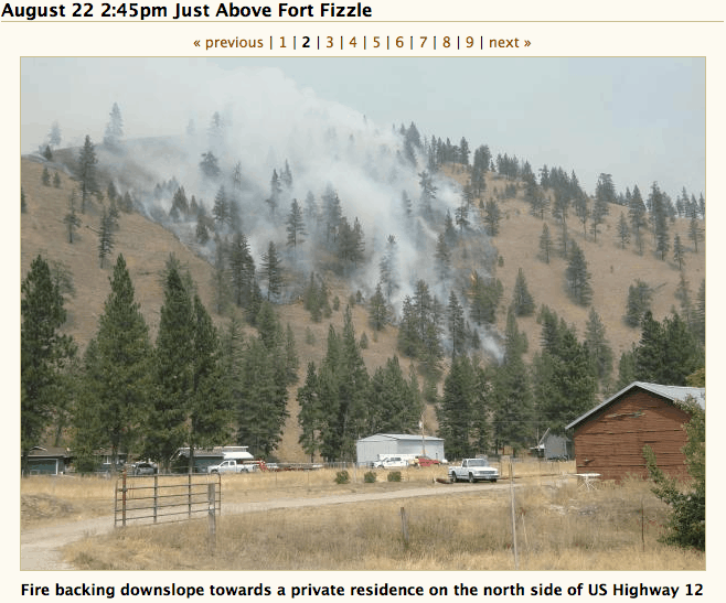
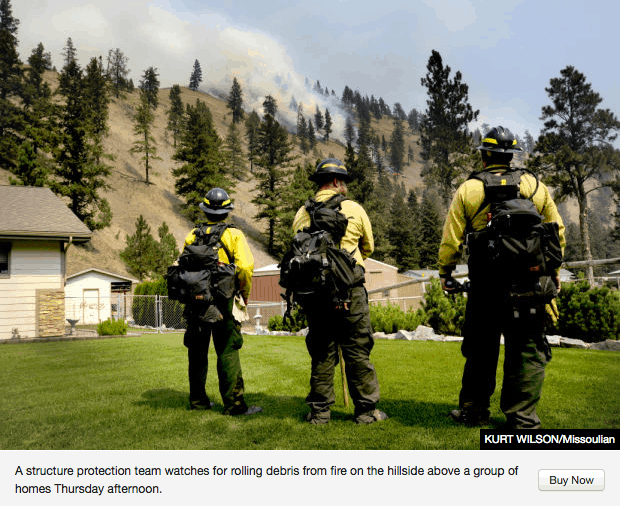
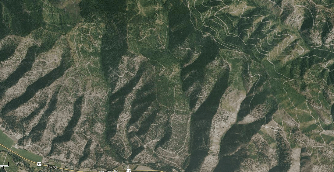
Is the US Government favoring environmental activists over ranchers?

This post is sort of a follow-up to a previous 3-part series of posts on this blog, “Cows vs. Fish,” that also featured some work (and help) from the Budd-Falen Law Offices in Wyoming. It was written in June, nearly three months ago, but has been making the rounds of email discussion groups during the past two days. You can probably pick up the bias by Budd-Falen’s description of Western Watersheds Project as a “radical environmental group,” but that has little to do with whether the contents and questions are accurate, or not. Other thoughts?

BUDD-FALEN LAW OFFICES, LLC
DATE: JUNE 25, 2013
RE: FREEDOM OF INFORMATION ACT ABUSE

Since 2009, Western Watersheds Project (“WWP”) has issued at least 675 Freedom of Information Act (“FOIA”) requests just to the BLM and Forest Service, related to livestock grazing on the public lands. Although I did not read all 675 requests, I did find some letters that demanded information for as many as 50 allotments in one single FOIA request. Most WWP FOIAs also wanted documents from multiple years and on multiple subjects. Many of the requests included instructions to the BLM or Forest Service offices stating that the response to WWP should be sent electronically or in a certain format. While the FOIA requires that the federal government make certain documents available, can a requester really dictate the format of the response?

Additionally, for every request, WWP argues that they should receive all information free of charge because they are:

a non-profit membership organization dedicated to protecting and conserving
the public lands and natural resources of watersheds in the American West.
WWP has over 1200 members . . . . WWP is active in seeking to protect and
improve the riparian areas, water quality, fisheries, wildlife, and other natural
resources and ecological values of western watersheds. To do so, WWP
actively participates in agency decision-making concerning BLM [Forest
Service] lands throughout the West, and the BLM’s management of livestock
grazing in Idaho, Nevada, Utah, and Wyoming.*

WWP is effective at increasing public awareness of environmental matters,
such as protection of the diverse and valuable sagebrush-steppe ecosystem,
through public education and outreach, participation in administrative
processes, litigation and other enforcement of federal environmental laws.

(*WWP uses this same language to justify its fee waiver requests in Montana, California, Arizona and New Mexico as well).

In contrast, if a rancher/permittee requests that very same information about his allotment requested by WWP, the BLM or the Forest Service will charge him $42.00 per hour for administrative search time and $.15 per page for each photocopy made. It seems backwards to me that a rancher is charged for “administrative search time” and photocopy costs to see what is in his own files, yet a group whose stated goal is to “get cows off the public lands ASAP” gets that exact same information for no charge at all (not even charging out-of-pocket costs).

In addition to the shear volume of FOIA requests and the mass of information requested in each of the individual requests by WWP, other issues are of note:

First, in addition to requesting information about individual allotments or groups of allotments, some of WWP FOIAs request documents and information about named individuals. Of the FOIAs I reviewed where WWP wanted information about named ranchers or other individual ranchers, not one of the ranchers was contacted by the BLM or Forest Service before their information was released to WWP.

Second, a great number of FOIAs requested the same information over and over. For example, in 2009, a FOIA would request all monitoring data “gathered or generated to date” for an allotment or large group of allotments. The exact same FOIA will then be filed in 2010 requesting all monitoring data “gathered or generated to date” about the same allotment or groups of allotments. The same FOIA will then be filed in 2011. There is no mention in any of these FOIAs that the BLM or Forest Service had already supplied a great deal of the requested information in the past–the agency simply has to relocate and copy the same information over and over again–all at the public’s expense.

Third, if these radical groups do not receive the information they want – for free – federal court litigation follows, again at the taxpayers’ expense. The vast amount of FOIA cases filed by environmental groups only included the filing of a federal district court complaint, a settlement agreement for the release of the requested information and the payment of attorneys fees. Fee payments were anywhere from $5000 to $50,000.

In May, 2013, the Chairman of the Committee on Oversight and Government Reform for the U.S. House of Representatives, the Ranking Members of the Committee on Environment and Public Works and the Committee on the Judiciary for the U.S. Senate sent a letter to the Environmental Protection Agency (“EPA”) strongly questioning EPA’s practice of “readily grant[ing] FOIA fee waivers for liberal environmental groups – effectively subsidizing them – while denying fee waivers and making the FOIA process difficult for states and conservative groups.” It is clear from the above research that the EPA is not the only agency who engages in such practice. Ranchers who should have the information that is kept in their files are forced to pay excessive amounts for information while radical environmental groups pay no fees for using this exact same information to file substantial numbers of administrative appeals and federal court litigation against these ranchers. With these radical groups, it is not a matter of providing fair public information; it is a matter of pushing a political agenda being subsidized by the taxpayers.

While there is no question that FOIA is an important statute to allow the public to get information from the federal government, this short essay points out the serious inequities in how the statute is implemented. Individuals are forced to pay search time and copy costs for the information gathered about them and located in their own files, while radical environmental groups can get the same documentation for free to use in litigation against the federal agency and rancher. Is that really the purpose of FOIA?

Fire Fighting is Like Health Care

Suppression Cost

Health care and fire suppression costs have increased in real dollars dramatically during the last 30 years.

U.S. per capita health care expenditures have gone up about 7 fold in real dollars (net of inflation).

The graph above shows that federal wildland fire suppression cost per ignition (in real dollars) has increased 4-fold during the same period (source data can be found here).

At the risk of unduly straining the analogy, the real cost increases in both sectors are likely a sign of underlying “unhealthy” conditions. Too much biomass — obesity & overstocked forests — can lead to inflammation. And of affluence. Too much technology to finance end-of-life care and too much expensive end-of-forest air attack.

Not too many “things” have suffered this magnitude of real cost increases — certainly not wages (flat) nor gasoline (decline).

Federal Judges 1, Forest Scientists 0 (Again)

This was printed this afternoon in Indiana, in “The Republic”: http://www.therepublic.com/view/story/292cede3ef954069b9b0a0ebd7d17a01/OR–Threatened-MurreletsMarbled murrelet critical habitat protections to stay in place for now

By STEVEN DUBOIS

PORTLAND, Oregon — A federal judge has handed the timber industry another defeat in its effort to expand logging on the habitat of a threatened coastal seabird.

U.S. District Court Judge John Bates in Washington D.C. said marbled murrelets will keep their Endangered Species Act listing, and rejected an argument that central California murrelets, which are doing poorly, should not be lumped in with the populations in Oregon, Washington and Northern California.

Bates also ruled old-growth forest habitat will remain protected during a three-year period when the U.S. Fish and Wildlife Service re-examines what it considers a flawed 1996 critical habitat designation.

“The court is not in a position to fully assess the seriousness of the deficiencies or to predict whether or how the new designation will differ from the current designation,” Bates said in an opinion Thursday.

The marbled murrelet was listed as threatened in 1992, and habitat protection has meant less logging in the Pacific Northwest. The tiny sea birds venture inland to raise their young and depend on old-growth forests for nesting.

“The timber industry keeps pushing to log this bird’s habitat and is using, I think, increasingly desperate tactics to try to say that we shouldn’t be protecting this bird and its habitat,” said Kristen Boyles, an attorney for Earthjustice. “I think it’s time for timber to figure how to live with this bird.”

The lawsuit was the timber industry’s fourth attempt in the past decade to eliminate protections for the forests that marbled murrelets call home, despite undisputed scientific evidence that murrelets are continuing to disappear from the coasts of Washington, Oregon and California.

The lawsuit was brought by the American Forest Resource Council, Carpenters Industrial Council and Oregon’s Douglas County.

Tom Partin, president of the AFRC, a timber industry group, said he had yet to hear about the ruling. He said the critical habitat portion of ruling was concerning, and that the council continues to believe that food shortages in the ocean are a bigger problem for the birds than limited nesting habitat.

“From our perspective, there has always been enough habitat for the nesting part of it,” Partin said. “It’s been the other aspects of their life cycle that may have the biggest influence on the marbled murrelet.”

Corral Complex takes on a Direct Attack!

This was just posted earlier today in the Humboldt County North Coast Journal Blogspot: http://www.northcoastjournal.com/Blogthing/archives/2013/09/05/firefighters-shift-to-direct-attack-on-corral-complex

Nearly a thousand firefighters this week are going on the offensive in their battle against the Corral Complex wildfires burning in the Six Rivers National Forest, just east of the Hoopa Valley Indian Reservation. After two weeks of road-clearing, bulldozing and other “indirect” efforts at containment — and with milder weather forecast through Friday — fire crews saw an opportunity to move in.

“On Monday, firefighters began an aggressive attack on the 26 miles of open line along the fire’s edge,” says a Forest Service press release. 

This “direct attack” strategy, which enlists hotshot crews and mass deliver of water by air, “is likely to contain the fire sooner, limit firefighter exposure, increase public safety and reduce final cost,” the press release states. The Corral Complex fires cover more than 12,000 acres and are 67 percent contained.

(For an inside look at the fire battles, see last week’s cover story, “Anatomy of a Fire Fight,” by Emily Hamann.)

Meanwhile, more than 200 more firefighters are battling blazes across extremely difficult terrain in the Forks/Orleans Complex, which includes the Butler Fire and the Salmon Fire near Forks of the Salmon. Those fires cover more than 20,000 acres and are just 55 percent contained.

Here’s the press release on the Corral Complex:

Since Monday, there has been a shift in fire suppression tactics on the Corral Complex. Incident Commander Jeanne Pincha-Tulley said, “We have a chance right now to contain this fire quickly and keep it about 6,000 acres smaller thanks to the excellent work done by California Team 5. The indirect line they put in place gives us a contingency plan if our plan doesn’t work, but if the weather pattern holds, we have a very high probability of success with direct attack.”

During the two previous weeks, firefighters completed indirect fire line to the west and south of the fire by developing a system of cleared roads connected to bulldozer lines which were tied into the north containment line in order to hold the oncoming fire. This indirect strategy was chosen when the fire was moving rapidly in steep terrain under conditions that were too hazardous for direct attack. The next step using the indirect strategy would be firing operations to remove unburned fuel between the indirect line and the main fire.

However, with the indirect line completed, and mild weather forecasted until Friday, California Team 3 recognized a window of opportunity to use an alternative strategy which is likely to contain the fire sooner, limit firefighter exposure, increase public safety and reduce final cost. This alternative direct attack strategy will use hotshot crews, mass-delivery of water by air, and medical response contingency resources to mitigate the risk of working in the complex terrain of the Trinity Alps Wilderness.

On Monday, firefighters began an aggressive attack on the 26 miles of open line along the fire’s edge, while the last four miles of indirect line were still being completed. Type 1 helicopters dropped 250,000 gallons of water along the fire perimeter, reducing the fire’s heat and creating areas that firefighters can now safely enter to construct direct handline or mop up hot spots. Seven hotshot crews hiked into the northwest and west sides of the fire and are camping out near the fireline during this multi-day campaign.

On Tuesday, two airtankers began dropping loads of clean water along the perimeter; particularly on the south side where near vertical terrain continues to prevent the use of handcrews. Aerial water delivery along the fire perimeter is typically done to support crews working on the ground. Intensive use of water along an inaccessible fire perimeter without crews is not typical. In this case, aircraft will systematically deliver mass-loads of water along the perimeter, targeting pockets of heat, burning snags, and other areas of concern. Both water drops to support handcrews and spot-cooling along the perimeter are being used on the Corral Complex.
All firefighting strategies involve some level of risk which must be carefully weighed with risk mitigations and benefits.

The risks and mitigations associated with California Team 3’s current plan of direct attack are:

• The use of fixed winged aircraft and helicopters increases exposure to aircraft hazards, but is mitigated through the short duration of use, limiting pilot flight hours, and other aspects of the aviation safety plan.

• Trace amounts of retardant in airtankers could impact sensitive aquatic species, but is mitigated by doing initial drops on the ridge tops to avoid riparian areas and human drinking water supplies. Retardant is not being used in the wilderness, or on sensitive watersheds or cultural resources in the fire area.

• Use of handcrews in steep terrain is mitigated by using highly experienced hotshot crews with short term exposure, cooling the fire’s perimeter with mass-delivery of water, and providing support with Rapid Extraction Modules and a hoist capable helicopter for emergency medical response.

• A change in weather to hot dry conditions with a possible increase in wind or fire behavior, particularly an offshore east wind event which is more frequent in Northern California at this time of year, is mitigated by the contingency plan of using the indirect line and firing operations to contain the fire.

The benefits associated with California Team 3’s current plan of direct attack are:
• Fire containment will be achieved more quickly.

• A shorter duration fire will reduce firefighters exposure to risks associated with heat, smoke, hazardous mountain roads, snags, fatigue, and steep terrain.

• Smoke impacts to communities will be reduced.

• Fire suppression costs will be reduced.

• The number of acres burned will be reduced.

• Fire repair and rehabilitation costs will be reduced.

• Using water without retardant will allow aerial attack both in drainages and on ridges, limiting fire spread from rolling burned material which has been a major contributor to fire growth.

• Negative impacts to local traffic caused by fire equipment on the roads will be reduced.

• Use of water rather than fire retardant will eliminate ecological concerns in riparian areas and protect wilderness values.

• Use of water rather than fire retardant will protect the drinking water supply for the Hoopa Valley community.

• Use of water rather than fire retardant will ensure effective firing operations if tactics must be changed in response to weather, since fire retardant makes it more difficult for vegetation to burn.

ESA and Cypress Tree Listing

The article from Greenwire, below, and this excerpt from the USFWS’s new proposed rule, beg the question: Couldn’t, shouldn’t the agency have obtained better data before listing the Santa Cruz cypress tree as endangered?

“After more accurate
mapping (McGraw 2007, entire), we
now estimate that areal extent totals
approximately 188 ac (76 ha) (Service
2013, p. 43). Additionally, estimated
abundance of individuals in all
populations has changed over time,
from approximately 2,300 individuals at
the time of listing in 1987, to a current
range of 33,000 to 44,000 individuals
(although the latter estimate is variable
due to mortality and regeneration
following the 2008 Martin Fire that
burned 520 ac (210 ha) of land and a
portion of the Bonny Doon population)”

And maybe the cypress stands need some thinning?

Steve


Agency proposes reducing protections for Calif. cypress tree

Laura Petersen, E&E reporter

Published: Tuesday, September 3, 2013

The Fish and Wildlife Service today proposed downlisting the status of the Santa Cruz cypress tree from endangered to threatened.

Found only in a small part of the Santa Cruz Mountains in California, the cypress is no longer at imminent risk of extinction from development, logging or agricultural conversion, the agency said in its proposed rule published today in the Federal Register.

The trees grow on lands managed for conservation by the state and by a private landowner. However, the species faces a number of other threats, so still requires the protection of the Endangered Species Act, the agency said.

“[T]hreats associated with alteration of fire regime and lack of habitat management continue to impede the species’ ability to recover,” the agency wrote in the proposed rule.

The Santa Cruz cypress tree was listed in 1987, when officials estimated 2,300 individuals remained. As information has improved, the agency said that was likely an underestimate. Between 33,000 and 44,000 cypress trees are now estimated to grow across about 188 acres.

The Pacific Legal Foundation petitioned in 2011 to downlist the tree, along with a handful of other species, and sued FWS in April for missing the deadline to issue a proposed rule. The group argues that endangered species listings affect property owners’ rights and can require landowners to undertake costly consultations to receive development permits.

However, the downlisting “does not significantly change the protections afforded this species under the Act,” according to the proposed rule. As before, all federally funded or permitted activities must not jeopardize the cypress’ long-term survival.

Conservationists applauded the proposal.

“The remarkable rebound of this precious little California evergreen is the latest proof that the Endangered Species Act puts species on the path to recovery,” said Angela Crane, endangered species organizer at the Center for Biological Diversity.

Efficacy of Whole Tree Harvest Thinning in Reducing Fire Severity

Image
Don’t ya love the black trunk scorching. Classic ponderosa. Color these photos black and white and you can step back in time 150 years ago. This was your pre-settlement forest. The Park retained a nice “clumpy” layout here.
Image
A more traditional spacing of 25 feet between trees. The 25′ spacing is the minimum to stop a crown fire. Don’t ya love that grass!


The photos above were taken at Chadron State Park in the northwest corner of Nebraska. You couldn’t find a more warm/dry Ponderosa Pine habitat than this with annual precipitation of around 16 inches. As with most recreation areas in the West that sought to “preserve,” very little logging occurred in the last one hundred years (if any) and the average tree spacing was around 8-10’. I visited the park about 6 years ago right after the Park did a whole tree harvest thinning fuels treatment in anticipation of a wildfire just like the one that burned through last summer.

When looking at these photos, some would make the claim that this proves “fuels treatments don’t stop wildfires” and end their analysis there. But that ignores the fact that while 90% of the 1000 acre park burned, 80% of the forest is still green while 100% of the adjacent USFS lands is black having suffered a stand replacing crown fire. The “surface fire” in the Park was extinguished before it burned the 10% of the Park that contained 30 rental cabins, 80 camp sites, a lodge, picnic sites, and assorted infrastructure. Fuels treatments don’t stop fires, but that’s where firefighters stop them. The thinning in the park turned what would have been a stand replacing crown fire into nothing but an unscheduled prescribed fire. The thinning in the park turned what would have been a stand replacing crown fire into nothing but an unscheduled prescribed fire. But…but…but…of course, I suppose it “is” possible the Park survived because “the wind” just stopped blowing when the fire reached the section line dividing the Forest Service property from the Park.

Fuels treatments isn’t about “stopping the fire.” We’d have to pave it over to do that. Fuels treatments is about making it easier for firefighters to extinguish the fire but most importantly it’s about “what’s still green” after the fire. Because of the fuels treatments, a 70 year legacy of family reunions, weddings, and cool shady getaways on hot August weekends can now continue for generations to come. Every local, state, and federal recreation area in the West should be, and is, doing these kinds of fuels treatments. What better place to showcase the “efficacy of fuels treatment.” When the public sees these “green islands” in a sea of black untreated forests….they’re gonna wonder why the USFS didn’t do them everywhere.


The bottom two photos are examples of Whole Tree Harvesting. 

Image
Whole tree harvesting one week after logging. Note the light on the land touch and total absence of any “slash.” The bottom photo is one “day” after logging. Absolutely no slash or surface fuels. This stand was pre-commercially thinned 30 years ago and had a tree every 8 feet.Image
Image
The best kept secret of forestry is the “thinning release.” Thinning greatly increases the diameter growth rate of the remaining trees. This tree put on 7″ diameter growth in the 32 years since it was thinned in 1972, and about 10 times the cross section volume growth than in the first 46 years. In 20 years, the trees in Chadron Park will be 18-20″ diameter. A nice legacy for the next generation I’d say…considering the alternative.


Lolo Creek Complex: Rewind the clock, what would you have done?

Google Earth image showing a pre-fire portion of the landscape now burning as part of the Lolo Creek Complex, currently the nation's number 1 priority fire.  For orientation purposes, the picture icon on the middle-bottom of the image is "Fort Fizzle" (a temporary military post erected in July 1877 by the U.S. Government to intercept the Nez Perce Indians [including women and children] in their flight from Idaho across the Lolo Pass into the Bitterroot Valley....and eventually to the Big Hole, Yellowstone and then all the way up to Canada).    The road at the bottom of the image is US Hwy 12 and you'll notice a fair number of homes and neighborhoods scattered along the highway.  The two other pictures in this post (below) were taken near Hwy 12 and are looking to the north on the slopes above Fort Fizzle.   According to a property ownership search on the official State of Montana site, nearly all of the land in this image north and above the highway is owned by Plum Creek Timber Company, although 3/4 of a section is owned by "YT Timber" out of Townsend, MT (likely connected to RY Timber in Townsend) and nearly 1/2 a section is owned by "BFP Partnership" from Missoula (which appears to be a development company).   If we could turn back the clock to pre-Lolo Creek Complex what specific land management activities would you recommend in this landscape in terms of restoring the forest, addressing "fuels" or protecting the homes and neighborhoods from the inevitability of wildfire?
Google Earth image showing a pre-fire portion of the landscape now burning as part of the Lolo Creek Complex, currently the nation’s number 1 priority fire. For orientation purposes, the picture icon on the middle-bottom of the image is “Fort Fizzle” (a temporary military post erected in July 1877 by the U.S. Government to intercept the Nez Perce Indians [including women and children] in their flight from Idaho across the Lolo Pass into the Bitterroot Valley….and eventually to the Big Hole, Yellowstone and then all the way up to Canada). The road at the bottom of the image is US Hwy 12 and you’ll notice a fair number of homes and neighborhoods scattered along the highway. The two other pictures in this post (below) were taken near Hwy 12 and are looking to the north on the slopes above Fort Fizzle. According to a property ownership search on the official State of Montana site, nearly all of the land in this image north and above the highway is owned by Plum Creek Timber Company, although 3/4 of a section is owned by “YT Timber” out of Townsend, MT (likely connected to RY Timber in Townsend) and nearly 1/2 a section is owned by “BFP Partnership” from Missoula (which appears to be a development company). If we could turn back the clock to pre-Lolo Creek Complex what specific land management activities would you recommend in this landscape in terms of restoring the forest, addressing “fuels” or protecting the homes and neighborhoods from the inevitability of wildfire?

It’s a smokey, rainy morning here in Missoula. After over three weeks without a computer (well, if you don’t count borrowing the wife’s computer at 5 minute intervals) due to a fairly significant hard-drive crash I’m back in the game, which I’m sure will be of great joy to some people.

Before the hard-drive crash I couldn’t even have dreamed of running something like ‘google earth’ on my computer. But my tech guy has this computer running better than new, so I spent some time on ‘google earth’ this morning. Really, it was Derek W who put the idea in my head, as a comment from him elsewhere on the blog mentioned that the area burned by the West Mullan fire near Superior, MT was now ‘refreshed’ on ‘google earth.’

So at the top of this post is an image of the landscape that’s now burning as part of the Lolo Creek Complex wildfire. I put quite a bit of information in the caption above, including the fact that Plum Creek Timber Company owns almost all the land in the image, so I won’t repeat it here, except to again ask an honest question:

If we could turn back the clock to pre-Lolo Creek Complex what specific land management activities would you recommend in this landscape in terms of restoring the forest, addressing any “fuels” concerns and/or protecting the homes and neighborhoods from the inevitability of wildfire?

Like I said, this is an honest question, especially in the context of all the debates and discussions we’ve had on this blog about the need to “do something” regarding forest restoration or dealing with “fuels” or protecting homes and communities from wildfire.

To date, according to the official Inciwb report on the fire, 9504 acres have burned. Of that 83% is private land, the vast majority of which is owned by Plum Creek Timber Company. There are currently 652 firefighting personnel on the fire and, according to the Missoulian, some of the firefighting crews are being flown in from as far away as Virgina and Michigan. Additional resources include 9 helicopters, 31 engines, 14 dozers and 9 water tenders.

Photo and text from Inciweb.

Missoulian Fort Fizzle

USFS To Take Back SRS Funds

You’ll probably see this in tomorrow’s papers — especially here in Oregon, which stands to lose $4 million.


http://www.washingtonpost.com/national/ap-newsbreak-forest-service-taking-back-federal-funds-governor-refused-to-return/2013/08/22/9274ef6c-0b66-11e3-89fe-abb4a5067014_story.html

Forest Service taking back federal funds from 22 states

By Associated Press, Updated: Thursday, August 22, 2:42 PM

JUNEAU, Alaska — The U.S. Forest Service plans to take a portion of the timber payments it has promised or paid out to 22 states, citing federal budget cuts.

Collection letters from Forest Service Chief Thomas Tidwell went out to governors around the country Monday, saying money would be taken from funds used for habitat improvement and other national forest-related projects that put people to work under the Secure Rural Schools and Community Self-Determination Act.

Oregon stands to lose the most in the move, with nearly $4 million in reductions. That would leave the state with about $3.4 million under that program.

California would lose nearly $2.2 million, leaving it with about $1 million for the program. Idaho is set to lose $1.7 million, Montana nearly $1.3 million and Alaska, about $930,000 — nearly half the total allotment it had been expecting.

Earlier this year, Tidwell sent letters to 41 states, asking for the return of $17.9 million in timber payments used to pay for schools, roads, search and rescue operations in rural counties and conservation projects.

“We regret having to take this action, but we have no alternative under sequestration,” Tidwell said in his letter to Alaska Gov. Sean Parnell, dated March 19.

Alaska was given the option of having about $826,000 the state had received or expected under the act reduced from its so-called “Title II funds,” for habitat improvement and other projects, or getting a bill for the money that had already been paid out under other sections of the act. Parnell refused, saying there was no basis in law for the request.

It wasn’t immediately clear why the agency was taking a greater share of funds from Alaska now.

Parnell spokeswoman Sharon Leighow said by email that the state will be exploring all options to address the agency’s actions, “as an individual state and in concert with other states.”

The Western Governors’ Association, in a letter to U.S. Agriculture Secretary Tom Vilsack in May, said the budget act that triggered the automatic federal budget cuts, known as sequestration, does not include language authorizing “retroactive application of the spending reductions or limitations. Nor does it contain language requiring reimbursement of funds that were already distributed in order to satisfy spending limitations.”

The Forest Service falls under the Department of Agriculture.

The Associated Press reported Wednesday that the Forest Service was diverting $600 million from other areas to put toward wildland firefighting efforts.

Agency spokesman Larry Chambers said the Forest Service had been dealing with the issue of collections under the Secure Rural Schools act since March, “well before any decision was made regarding transfer of fire funds.”

___

Lolo Creek Complex: Majority of acres burned owned by Plum Creek Timber Co

To date, the vast majority of the land burned in the Lolo Creek Complex fire has been heavily logged, roaded and weeded sections owned and managed by Plum Creek Timber Company

On Wednesday, the Lolo Creek Complex fire was named the nation’s Number 1 firefighting priority. Over the past few days the fire has made a number of good runs due to winds approaching 50 miles per hour and humidities in the teens. This has all been reported in the media.

What hasn’t been reported in the media at all is the fact that the majority of the acres burned to date as part of the Lolo Creek Complex fire have burned on lands owned and managed by Plum Creek Timber Company. Much of that Plum Creek Timber Company land has been heavily logged, roaded and infested with noxious weeds.

According to the official Inciweb report on the Lolo Creek Complex fire, to date the fire has burned 1,455 acres of the Lolo National Forest and 7,143 acres of private land. For what it’s worth, much of the Lolo National Forest land burned in this fire to date could also be characterized as heavily logged, roaded and infested with noxious weeds.

What Inciweb doesn’t tell us, or show, is that the vast majority of that private land burned to date in the fire is owned and managed by Plum Creek Timber Company.

To verify this fact I used the most current fire perimeter maps on Inciweb and then consulted with a tool called the Montana Cadastral, that I’ll sometimes use during hunting season to confirm land ownership. The Montana Cadastral is a Montana Base Map Service Center, which is a part of the Montana State Library. It provides the most up-to-date information concerning land ownership throughout Montana.

As anyone can clearly see using these tools, section after section of land owned and managed (mis-managed?) by Plum Creek Timber Company has burned as part of the Lolo Creek Complex fire. Currently, over 500 firefighters (and numerous helicopters, bull-dozers, tanker trucks, etc) are battling the fire. What the total cost of this fire to US Taxpayers will be is anyone’s guess. The total cost of all this fire suppression activity that will be paid for by Plum Creek Timber Company is likely a little easier to figure out.

Why the Montana media hasn’t utter one single word about the fact that the majority of land burning in this fire is owned and managed by Plum Creek Timber Company is a real mystery.

P.S. It’s also worth pointing out that another large chunk of the private land burned to date in the Lolo Creek Complex Fire is owned by Illinois-based Potomac Corporation. It’s tough to find info about them on-line, but they appear to be in the cardboard manufacturing business. Calls to their listed 847-259-0546 number have gone unanswered all day.