Smokey Bear on Parade

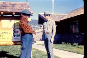
Bridgeport Ranger District Fire Control Officer Marion Hysell welcomed Smokey Bear to the Bridgeport Ranger Station on July 4, 1964. (Note: The 1960s-1970s era U.S. Forest Service shoulder insignia did not arrive in this corner of the Intermountain Region until 1966.)

As fire prevention guard on the Bridgeport Ranger District, Toiyabe National Forest, from 1963 through 1966, I continued the district’s practice of having Smokey Bear appear in Bridgeport’s famous Fourth of July parade. This small town of less than 400, nestled in a verdant valley of the same name at the foot of the eastern Sierra Nevada 85 miles south of Carson City, Nevada, and 85 miles north of Bishop, California, is county seat of Mono County, California, and a popular outdoor recreation center.

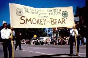
One of the larger guys on the fire crew or trail crew was cajoled into wearing the Smokey costume shipped our way from the regional office in Ogden, Utah, for this annual walk or ride down Main Street—U.S. Highway 395—lined by hundreds of local residents and summer visitors.

Smokey sometimes rode on a float accompanied by ranger station kids. On this occasion, as coordinated with the local 4-H Club and led by two of its members, he marched and waved to the parade’s appreciative onlookers.

After the parade, a properly-escorted Smokey always mingled with the crowd in town and then visited with kids in the Toiyabe National Forest’s large Twin Lakes area campgrounds.

Corporate Sponsorships for Ski Areas

U.S. Forest Service Lifts Advertising Ban; Vail, Jackson Hole, Mammoth, & More Announce Corporate Sponsorships

Partnerships range from chairlift and trail name sponsors to ski area name changes

Vail Mountain wants to Live Más
Vail Mountain, the largest ski area in Colorado and one of the most-visited in America, signed a 10-year, $100 million agreement with Taco Bell that will touch nearly every part of the resort.

What’s next? The Microsoft Old Faithful Inn?

Western Fire Regimes: Paper vs. Paper

This will take a deep dive, but it’ll be an interesting one. In “Countering Omitted Evidence of Variable Historical Forests and Fire Regime in Western USA Dry Forests: The Low-Severity-Fire Model Rejected,” by William L. Baker, Chad T. Hanson, Mark A. Williams, and Dominick A. DellaSala. In the journal Fire, April 3, 2023 (open access), the authors critique a 2021 study, “Evidence for widespread changes in the structure, composition, and fire regimes of western North American forests,” by a handful of noted scientists, such as Paul F. Hessburg, Susan J. Prichard, Scott Stephens, and several others, in Ecological Applications, August 2021 (open access).

Abstract of the first paper (emphasis added):

The structure and fire regime of pre-industrial (historical) dry forests over ~26 million ha of the western USA is of growing importance because wildfires are increasing and spilling over into communities. Management is guided by current conditions relative to the historical range of variability (HRV). Two models of HRV, with different implications, have been debated since the 1990s in a complex series of papers, replies, and rebuttals. The “low-severity” model is that dry forests were relatively uniform, low in tree density, and dominated by low- to moderate-severity fires; the “mixed-severity” model is that dry forests were heterogeneous, with both low and high tree densities and a mixture of fire severities. Here, we simply rebut evidence in the low-severity model’s latest review, including its 37 critiques of the mixed-severity model. A central finding of high-severity fire recently exceeding its historical rates was not supported by evidence in the review itself. A large body of published evidence supporting the mixed-severity model was omitted. These included numerous direct observations by early scientists, early forest atlases, early newspaper accounts, early oblique and aerial photographs, seven paleo-charcoal reconstructions, ≥18 tree-ring reconstructions, 15 land survey reconstructions, and analysis of forest inventory data. Our rebuttal shows that evidence omitted in the review left a falsification of the scientific record, with significant land management implications. The low-severity model is rejected and mixed-severity model is supported by the corrected body of scientific evidence.

I’d like to hear the response of Hessburg et al to the charge of “falsification,” something some scientists have accused Hanson of.

Jim Petersen on Lolo Forest Plan

From The Western News. Excerpt:

The new Lolo Forest Plan revision speaks to diversity, inclusion, social justice, wilderness and wild and scenic rivers, but not a peep about the economic importance of the Montana and Idaho timber industries or the wildfire/ forest health pandemic that grips national forests in both states.

I’ll skip the economic and social stuff because I know others won’t. But I refuse to whistle past the graveyard the Lolo is becoming. You can drive in any direction from Missoula and find visual proof of the power of science- based forestry: The late Steve Arno’s silvicultural research at Lick Creek, near Hamilton; the beautiful groves of ponderosa and larch on the back side of Seeley Lake; the park-like stands on ponderosa on both sides of Highway 135 north of St. Regis; and the thinnings my friend, Tim Hancock is doing on private land near Ravalli.

Far more trees are dying on the Lolo Forest today than when Leiberg saw it in 1898 because there are too many for the carrying capacity of the land.

The solution to this environmental injustice is simple: thinning and prescribed fire, thinning and prescribed fire. Repeat in perpetuity.

Why on earth is the Lolo staff ignoring this? Has anyone on the Planning Team read the Montana Forest Action Plan that the Forest Service helped develop and signed? It doesn’t look like it.

BLM Releases Proposed Plan to Guide the Balanced Management of Public Lands

PR from the BLM today:

Interior Department Releases Proposed Plan to Guide the Balanced Management of Public Lands

Public Lands Rule lays groundwork for conserving wildlife habitat, restoring places impacted by wildfire and drought, expanding outdoor recreation, and thoughtful development

WASHINGTON — Today the Department of the Interior published a proposal to guide the balanced management of America’s public lands for the benefit of current and future generations. The proposed Public Lands Rule provides tools for the Bureau of Land Management (BLM) to improve the resilience of public lands in the face of a changing climate; conserve important wildlife habitat and intact landscapes; plan for development; and better recognize unique cultural and natural resources on public lands.

The proposed rule directly responds to the growing need to better manage public lands, waters, and wildlife in the face of devastating wildfires, historic droughts, and severe storms that communities are experiencing across the West, as well as to deepen BLM’s collaborative work with communities, states and Tribes to support responsible development of critical minerals, energy and other resources. The proposal is consistent with strategies used by other state and federal land management agencies to ensure the federal government has tools and direction to identify areas in need of restoration or conservation, as well as the ability to encourage investments in public lands to help balance the impacts of development. It will increase access to outdoor recreation by putting conservation on equal footing with other uses, consistent with the BLM’s multiple use and sustained yield mission.

“As the nation continues to face unprecedented drought, increasing wildfires and the declining health of our landscapes, our public lands are under growing pressure. It is our responsibility to use the best tools available to restore wildlife habitat, plan for smart development, and conserve the most important places for the benefit of the generations to come,” said Secretary Deb Haaland. “As we welcome millions of visitors to hunt, fish and recreate on our public lands each year, now is the time to improve the health and management of special places.”

“Our public lands provide so many benefits – clean water, wildlife habitat, food, energy and lifetime memories, to name just a few– and it’s our job to ensure the same for future generations,” said Bureau of Land Management Director Tracy Stone-Manning. “As pressure on our public lands continues to grow, the proposed Public Lands Rule provides a path for the BLM to better focus on the health of the landscape, ensuring that our decisions leave our public lands as good or better off than we found them. We look forward to feedback from the public on how this proposal will help us best uphold the BLM’s important mission.”

The proposed rule would build on the historic investments in public lands, waters and clean energy deployment provided by President Biden’s Bipartisan Infrastructure Law and Inflation Reduction Act by directing land managers to identify and prioritize lands and waters through the land management process that require habitat restoration work, such as removing invasive species or restoring streambanks. BLM lands are an economic driver across the West, and the proposed rule will ensure those lands and the resources they produce continue to be available for future generations.

It also proposes conservation leasing, a tool authorized by the Federal Land Policy and Management Act (FLPMA), to facilitate restoration work on public lands in cooperation with community partners. A conservation lease is a time-limited lease of public land that allows interested organizations to conduct specific restoration or mitigation activities and would generate revenue for the American taxpayer. This tool has the potential to expand opportunities to accelerate restoration of big game migration corridors or establish carbon markets, for example, and directly responds to comments from state and industry partners on the need for a reliable path on public lands by which to pursue compensatory mitigation to facilitate development projects.

The proposed rule includes a roadmap to align the BLM with other land management agencies, such as the U.S. Forest Service, in ensuring the agency is inventorying and assessing the health of public lands, including watersheds, forests and wildlife habitat. In light of the rapidly changing climate and increasing demands on public lands, the additional information will be used to identify trends, implement adaptive management strategies, and ensure decisions are informed by the best available science and on-the-ground monitoring. It will also be utilized during the existing land management planning processes to identify public lands in need of restoration work or intact landscapes that may be best managed for their contributions to healthy, functioning ecosystems or water quality.

The proposed rule also provides a framework for land managers to apply provisions of FLPMA that direct the BLM to prioritize the identification, evaluation and designation of Areas of Critical Environmental Concern (ACEC) through land use planning. ACECs are the primary BLM designation for public lands where special management is required to protect important natural, historic, cultural and scenic resources, systems or processes, or to protect life and safety from natural hazards.

The publication of the proposed Public Lands Rule in the Federal Register in the coming days initiates a 75-day public comment period. In addition, the BLM will host five information forums to discuss the details of the rule.


The BLM manages more than 245 million acres of public land located primarily in 12 western states, including Alaska, on behalf of the American people. The BLM also administers 700 million acres of sub-surface mineral estate throughout the nation. Our mission is to sustain the health, diversity, and productivity of America’s public lands for the use and enjoyment of present and future generations.

Can We Log Our Forest and Conserve It Too?

Here’s an interesting blog post by Alice Palmer focusing on BC, but applies elsewhere.

Can We Log Our Forest and Conserve It Too?

If we want to transition to a bioeconomy, we will need more biomaterials. Finding them won’t be easy.

Speaking at a recent forestry conference in BC, futurist Nikolas Badminton enthused about recent forestry innovations, such as mass timber high-rises, wood-based windows, and electricity-generating floors. Indeed, one has only to open their daily newspaper to be inspired about the promise of a “bioeconomy” replacing carbon-intensive materials such as cement or plastic with bio-based ones such as wood fibre.

Unfortunately, while wood is increasingly viewed as a climate-friendly building solution, the logging activities that provide this wood are not viewed in the same positive light. Indeed, many people believe industrial forestry to be environmentally damaging in terms of both carbon emissions and biodiversity conservation. These beliefs frequently carry over to the media and various levels of government.

In short, we want to “eat our cake and have it too” – use the wood, but preserve the forest. However, if we want to both take advantage of the multiple carbon benefits of building with wood and conserve 30% of the earth’s surface (as per the UN Convention on Biological Diversity), we’ll need to make some tough decisions.

The author continues with four hypothetical scenarios…. All worthy of discussion.

Scenario 4: Active land management

With climate change threatening biodiversity, conservation groups and the forest industry call a truce. Some forests are set aside for conservation purposes and others are designated for industrial wood production. Previously degraded forests are actively restored and intensive silviculture in the industrial forests reduces the risk of catastrophic wildfires and enables high-quality wood production. These industrial forests rapidly sequester carbon, contributing to global net zero emissions.

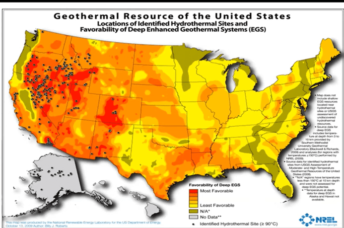
Can We Get There From Here? Wishful Thinking Meets Reality on Federal Lands.. Geothermal Version


This map is from an earlier presentation on this video at 23:15

The Western Governors’ Association has a whole series called “The Heat Beneath Our Feet” about geothermal.  At 28:14 of this video, Lorenzo Trimble of the BLM talks about the BLM process.

Apparently there is a Geothermal PEIS that amended 114 (!) land use plans to incorporate geothermal leases. Improved leasing on BLM and FS, and is not stale. In this presentation, the FS is one Surface Management Agency.

Personally I would prefer that people not say that using a CE (or CX in BLM-ese)  is “not NEPA” as that’s not what the regs say…

Interestingly if you have an oil and gas lease, you can non-competitively apply for a geothermal lease.

New study sounds alarm, provides hope for Western red cedars

Interesting article on the latest research. I would note that western redcedar may have done well and expanded its range during and after the Little Ice Age, and the species now grows (and is dying) in areas it in no longer adapted to. A researcher “found young Western red cedars growing alongside drought-hardy Oregon white oaks.” What’s more, the cessation of Indian burning in the Willamette Valley let cedars “invade” areas where previously they would have succumbed to fire. The same in true for Doug-fir — it’s not doing well in sites it wasn’t well adapted to.

New study sounds alarm, provides hope for Western red cedars

Research links cedar death to climate, details which trees are dying, which are surviving and shows how the species might be saved

Robinson Creek Fire

The Robinson Creek Fire, on June 29, 1964, burned 350 acres on Sawmill Ridge.


I was returning to the Bridgeport Ranger Station from an early morning patrol of the Green Creek and Virginia Lakes areas when I detected what became the largest wildfire the Bridgeport Ranger District would experience during my five Toiyabe National Forest fire seasons.

It was June 29, 1964, and having just passed through Bridgeport I was northbound on U.S. Highway 395 when, across Bridgeport Valley to the southwest, I first saw it. Sheep trailing on Timber Harvest Road? Or smoke? Smoke! Wispy white smoke!

Three miles to the ranger station, and maybe eight or ten to the smoke. I tried to raise the station on the radio as I pushed the gas pedal to the floor. The truck responded, but the station didn’t. A glance at my watch told me why. It was lunch time, and with the fire danger rated moderate the office wasn’t staffed. This was years before fire control officer Marion Hysell had a Forest Service radio crackling in his ranger station house day and night.

Two miles to the ranger station. I could have switched to channel two, raised the Toiyabe National Forest dispatcher in Reno, explained the situation, and asked him to telephone the FCO’s house. But I decided I could get there, tell him myself, pick up some help, and be on my way to the still wispy-but-thickening column of smoke before I’d half finish telling the dispatcher my story.

Two minutes later, I came to a dusty halt in front of the FCO’s house and passed the word. Then, with Don, the only crewman not out on project work, I headed up the Buckeye Road toward the fire. After alerting Ranger Hoag, who decided to man the office until the district clerk returned from lunch, the FCO loaded his Jeep with fire tools. As he wheeled toward the fire via Bridgeport and the Twin Lakes road, he confirmed my sighting to Ranger Hoag over the radio. Ranger Hoag alerted the supervisor’s office and the dispatcher, and ordered air tankers.

Fifteen minutes after leaving the station—probably twenty or so after I first saw the smoke—Don and I were speeding down Timber Harvest Road toward a blaze that, at about a mile’s distance, I estimated at ten to fifteen acres and spreading fast through cheatgrass and sagebrush toward the Jeffrey pine-clad slopes of Sawmill Ridge. Through the smoke, on the far side of the fire, a few people could be seen making vain attempts to stop it.

In what was a futile—and probably foolhardy—attempt to head off the fire before it could reach the timber, I left the road and, within a minute or two, Don and I were attacking flames running upslope along a two-hundred-yard to three-hundred-yard front. But two guys with a couple hundred gallons of water and hand tools, it rapidly became obvious, were no match for a fast-moving fire of that size.

About the time I recognized that truth, and also realized that my poor headwork was getting Don and me into more than a little trouble, I saw the FCO’s Jeep jounce over the sagebrush and halt some distance off. “Fall back! Let’s get this rig outta here!” he ordered as he ran our way. So, as I reeled in the hose, Marion maneuvered the patrol truck toward safety. Within a few minutes, the two vehicles and the three of us were back on Timber Harvest Road, and the scene of our “initial attack” was engulfed in flames.

Ranger Hoag’s pickup crossed the bridge over Robinson Creek and he joined us on the road as the fire, now all of an hour old, raced into the timber. Taking charge, he requested a spot weather forecast from Reno and, with the FCO, planned for the reinforcements starting our way.

Since little, if anything, could be done about the head of the fire—then moving rapidly upslope, torching and spotting in the timber—two rag-tag crews of mostly pick-up firefighters were deployed along its flanks to prevent it from spotting and spreading into the nearby resort and campground. From my smoke-choked vantage point with the Timber Harvest Road crew, the fire seemed to be living up to the expectations of the spot weather forecast. Superheated pines exploded. Deer, fleeing the flames, ignored me as they bounded across the road.

Just after two o’clock, an old ex-Navy TBM from Carson City made the first air drop of 600 gallons of bentonite slurry on the head of the fire. If this slowed its advance at all, it didn’t for long. It did boost our morale.

So did arrival of the first substantial reinforcements. Before the fire was two years old, fifty U.S. Marines from the Mountain Warfare Training Center at Pickle Meadows on the Sonora Pass road and sixty State of California inmates of the Inyo-Mono Conservation Crew near Bishop led by California Division of Forestry overhead were on the firelines. By three o’clock, over a hundred Marines were on the fire, and additional pick-up firefighters had been hired. And by four o’clock, when the air tanker’s scout plane had reported the size of the fire to Fire Boss Hoag at about 250 acres, fire control personnel from the West Walker, Alpine, and Carson ranger districts had begun to arrive. A project fire overhead team left Reno about five o’clock, and overhead also began traveling to Bridgeport from the Central Nevada and Las Vegas districts of the forest.

By late afternoon, the situation looked like the project fire it had become. The fire was divided into four sectors, with Marion Hysell as sector boss over Forest Service crew bosses, Marine Corps line workers, and three bulldozers on the “hot” up-hill end of the fire. A PBY and two TBMs made a second series of drops on the head of the fire. Much to my disappointment, I was assigned to set up the fire camp to receive firefighters and equipment as they arrived. By nightfall, the camp and the night shift had been organized. I was eventually relieved as camp boss and told to rest up for a day shift job.

I’ve spent more comfortable nights than that one in a paper sleeping bag out in the sagebrush. While I slept, the major battle of the campaign was fought at the top of Sawmill Ridge.

The plan was to take advantage of the cooling effects of the night air, which would slow the fire down, and stop it with a wide fireline at the top of the ridge. With seven cats and 76 men on this hot sector, Marion was building that line across the ridge from north to south. At eleven o’clock, he tied in with the southern sector’s line to contain the fire. But, two hours later, the wind shifted from the west to blow from the southeast and, as firefighters retreated for air and safety, the fire jumped the line. Another line was started to corral the blowup.

I awoke at first light to a transformed fire camp and landscape. The camp’s population had doubled, at least, and there seemed to be plenty of fresh firefighters for the day shift. A mobile fire weather forecasting unit, complete with spinning anemometer and other instruments, had arrived and was in business. Best of all, a field kitchen was serving breakfast. Dirty, cold, and sore, I ate.

I was assigned to the northern sector as a crew boss, and given a Marine Corps platoon as a crew. The platoon’s sergeant, probably figuring this young Forest Service fellow akin to a second lieutenant, suggested I work the crew-platoon through him. I readily agreed. I held a brief fire school to explain what we were going to do, how to use the tools, and safety before starting up the line. About the only problem I had, as we built fireline toward the ridgetop, was keeping them from bunching up—from working too close to each other for safety.

Fire Boss Hoag declared the fire controlled at noon, just 24 hours after it started. But there was still plenty of mop-up work left.

Late in the afternoon, my Marines and I were relieved by a Forest Service crew from Idaho, and at the end of the day shift I was released to resume fire prevention patrol duties the next morning.

There were plenty of questions to answer during that July first patrol of the Twin Lakes area. Thousands of campers and residents had watched the fire consume 350 acres of brush and timber between Robinson Creek and the top of Sawmill ridge, and everyone wanted to talk about it. I, of course, capitalized on their interest by pushing my fire prevention message. The fire that had so impressed them, we knew, had been man-caused. A couple little boys, the investigation determined, had built a “campfire” in the brush.

Although the fire camp was removed that evening and firefighters from other districts and forests were returned to their stations, mop-up continued for several days.

The smoke of the Robinson Creek Fire had barely cleared when, on July 9, Forest Supervisor Ivan Sack and Frank Dunning, his fire staff officer, conducted the district’s previously-scheduled fire preparedness and readiness inspection. Although we were still mopping up the big one, they told Ranger Hoag and Marion they were pleased with what they saw—including, much to my relief, my fire prevention program. But it seemed to me I was doing everything a fire prevention guard should do well—except preventing big fires.

On the evening of July 21, as I was completing a Twin Lakes patrol, I sighted and extinguished the last smoke. It was a smoldering stump about a third of the way up the ridge. The Robinson Creek Fire was officially out. But, in a way, it would never be out for me. As I crunched my way down the charred slope, it seemed this greatest defeat of my fire prevention career would burn forever in my memory.


Adapted from the 2018 third edition of Toiyabe Patrol,

the writer’s memoir of five U.S. Forest Service summers

 on the Toiyabe National Forest in the 1960s.